

Weather Webcast with Chief Meteorologist Tom Wachs
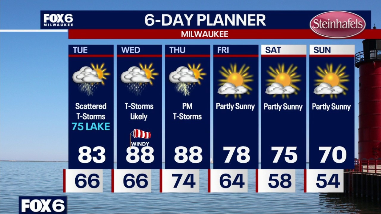
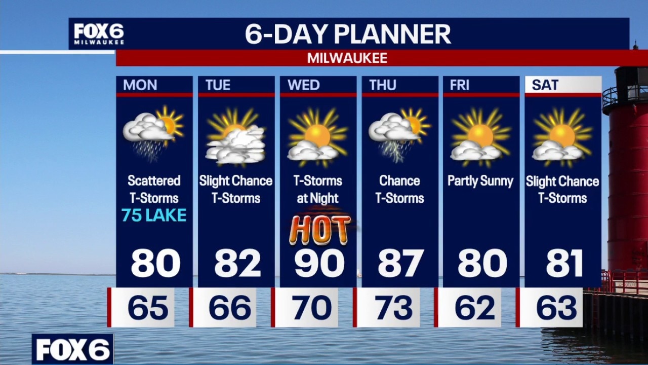
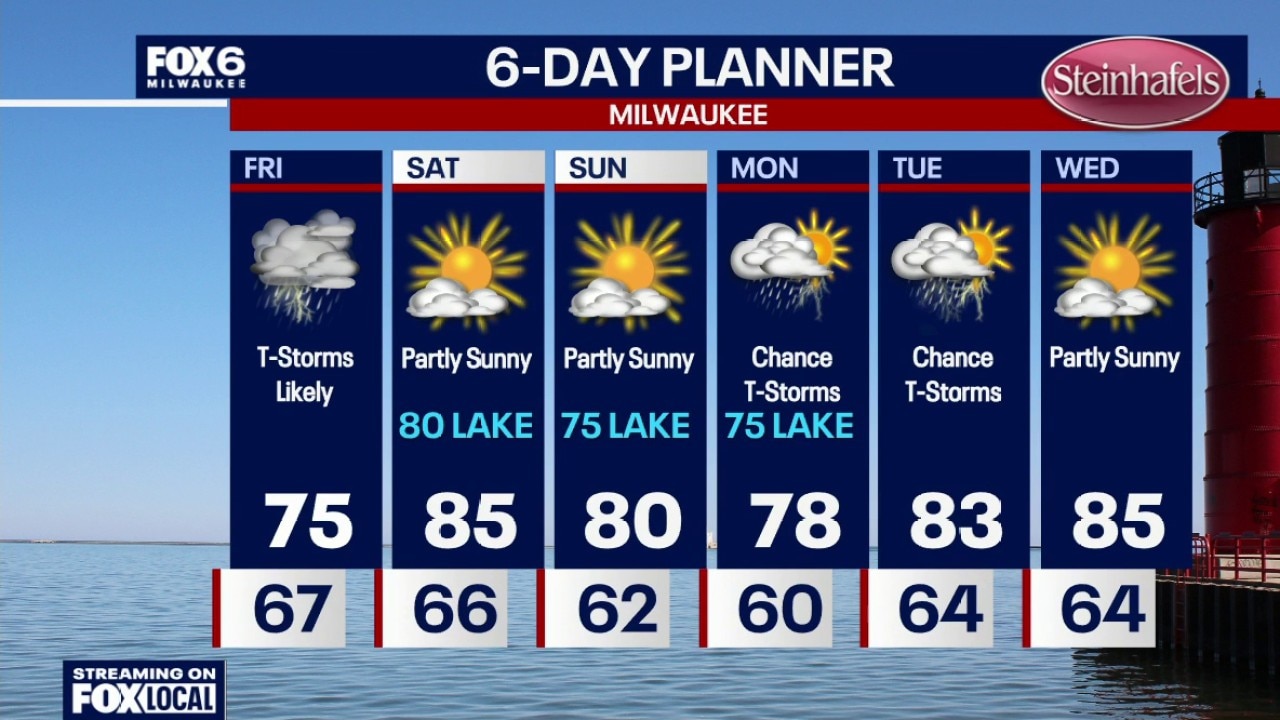
An isolated t-storm is possible overnight with patchy fog. Temperatures in the 60s. Scattered showers and t-storms (widespread) on Tuesday. Highs in the mid-70s near the lake, low 80s inland.
An isolated t-storm is possible overnight with patchy fog. Temperatures in the 60s. Scattered showers and t-storms (widespread) on Tuesday. Highs in the mid-70s near the lake, low 80s inland.
Weather Webcast with Chief Meteorologist Tom Wachs
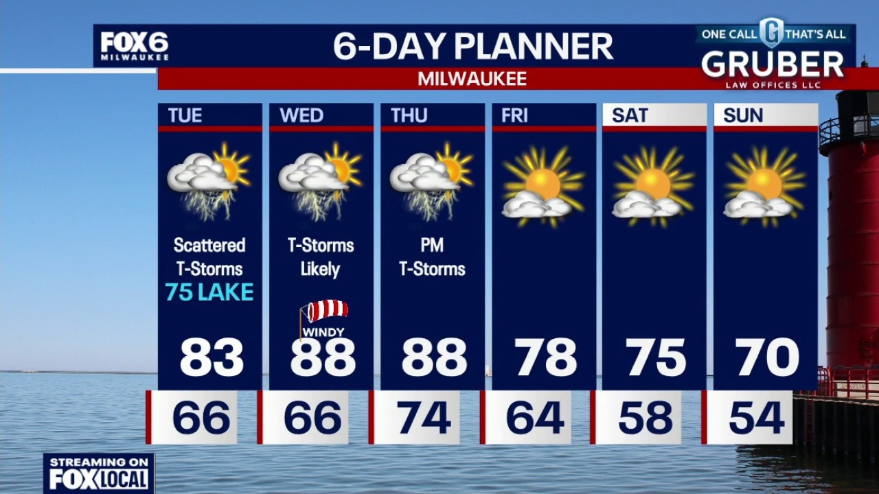
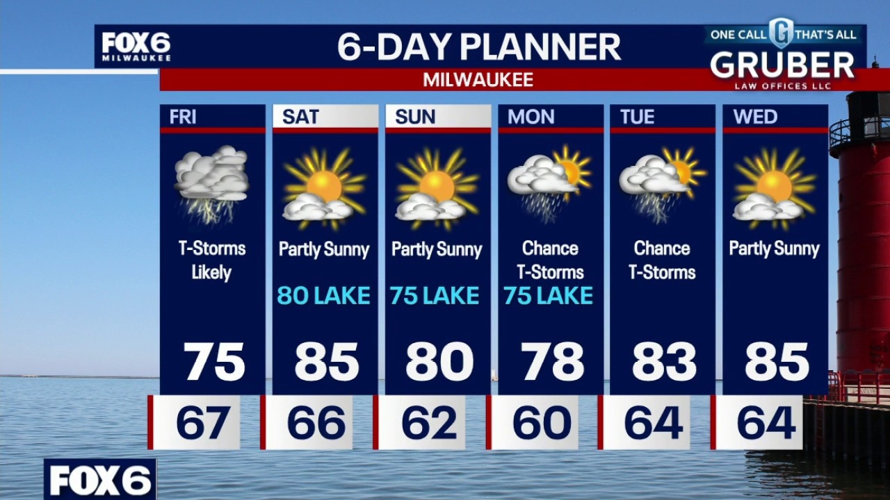
Scattered showers and t-storms tonight. Temperatures dropping into the 60s. Scattered showers and t-storms (widespread) on Tuesday. Highs in the mid-70s near the lake, low 80s inland.
Scattered showers and t-storms tonight. Temperatures dropping into the 60s. Scattered showers and t-storms (widespread) on Tuesday. Highs in the mid-70s near the lake, low 80s inland.
Weather webcast with Stephanie Barichello
A few early morning showers and isolated non-severe storms. Muggy. Warming up into the low 80s inland and mid-70s near the lake on Monday.
A few early morning showers and isolated non-severe storms. Muggy. Warming up into the low 80s inland and mid-70s near the lake on Monday.
Weather webcast with Lisa Michaels
A few early morning showers and isolated non-severe storms. Muggy. Warming up into the low 80s inland and mid-70s near the lake on Monday. Scattered rain and storms pick-up during the afternoon and evening.
A few early morning showers and isolated non-severe storms. Muggy. Warming up into the low 80s inland and mid-70s near the lake on Monday. Scattered rain and storms pick-up during the afternoon and evening.
Weather Webcast with Chief Meteorologist Tom Wachs
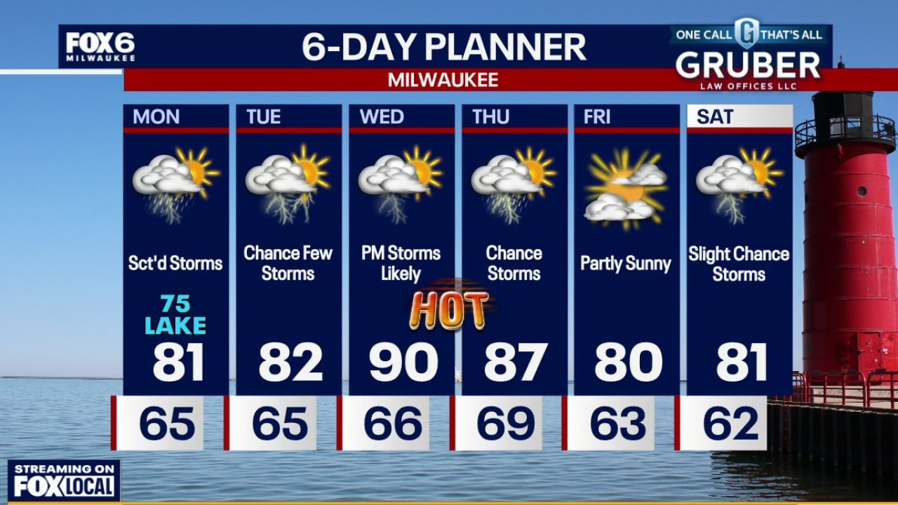
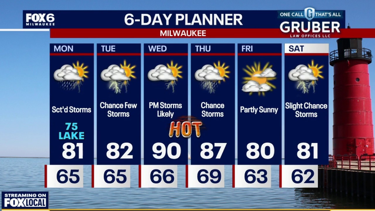
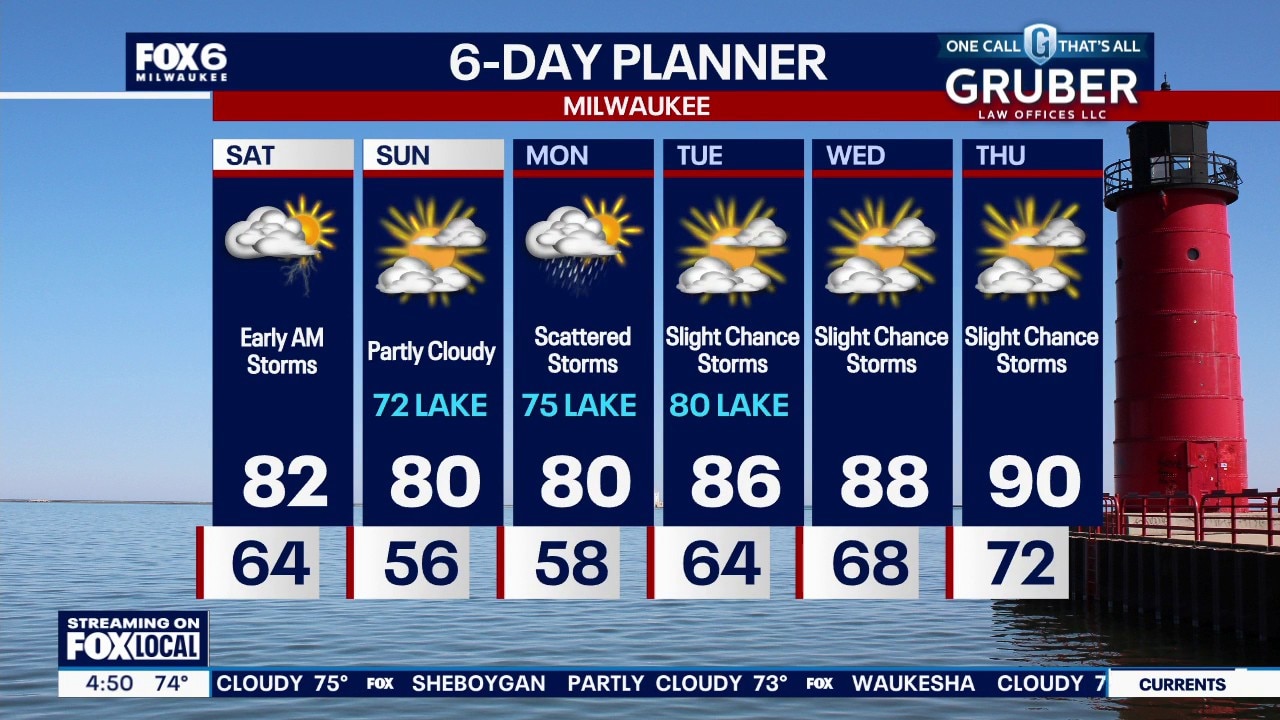
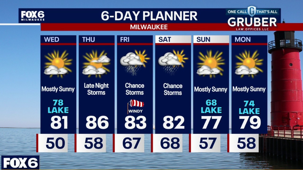
A few t-storms are possible this evening and overnight with temperatures dropping through the 60s. We have a soggy day on the way Monday, but not all day rains. Scattered t-storms likely, steadiest in the afternoon/early evening. Humid with a high around 80.
A few t-storms are possible this evening and overnight with temperatures dropping through the 60s. We have a soggy day on the way Monday, but not all day rains. Scattered t-storms likely, steadiest in the afternoon/early evening. Humid with a high around 80.
Weather webcast with meteorologist Lisa Michaels
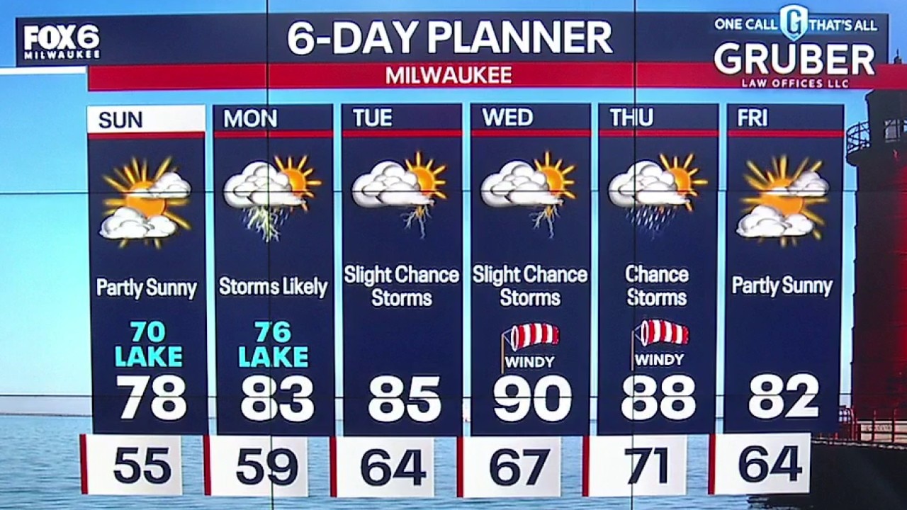
Partly sunny Sunday and the most comfortable day of the week! Highs in the upper 70s inland to low 70s near the lake with lower dew points. Waves of energy will increase the chances for rain and storms on Monday morning and afternoon.
Partly sunny Sunday and the most comfortable day of the week! Highs in the upper 70s inland to low 70s near the lake with lower dew points. Waves of energy will increase the chances for rain and storms on Monday morning and afternoon.
Weather Webcast with Holly Baker
Another partly sunny day is expected for Sunday!
Another partly sunny day is expected for Sunday!
Weather webcast with Meteorologist Lisa Michaels
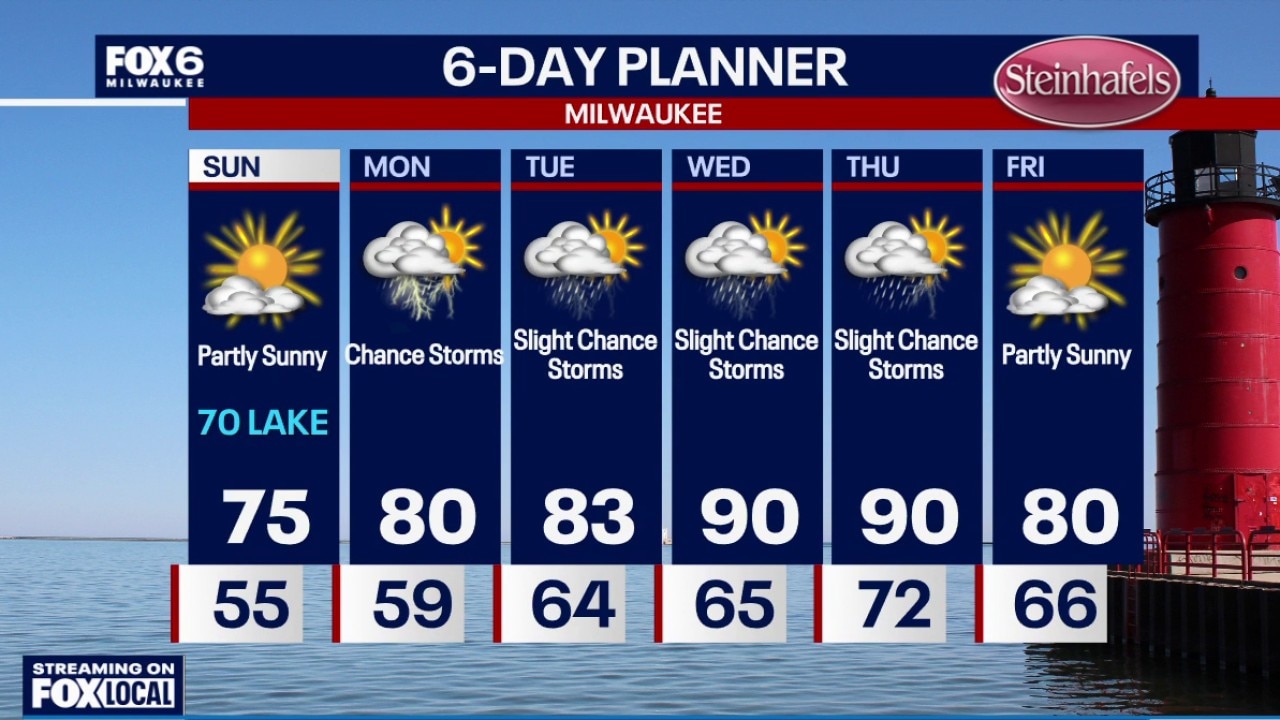
Isolated early fog. Partly cloudy in the morning to mostly sunny in the day. Highs in the upper 70s lakeside to low 80s inland and sticky. Partly cloudy Saturday night with lows in the mid to upper 50s. Patchy fog possible into Sunday morning.
Isolated early fog. Partly cloudy in the morning to mostly sunny in the day. Highs in the upper 70s lakeside to low 80s inland and sticky. Partly cloudy Saturday night with lows in the mid to upper 50s. Patchy fog possible into Sunday morning.
Weather Webcast with Holly Baker
We are tracking rain tonight and sunshine tomorrow.
We are tracking rain tonight and sunshine tomorrow.
Weather Webcast with Stephanie Barichello
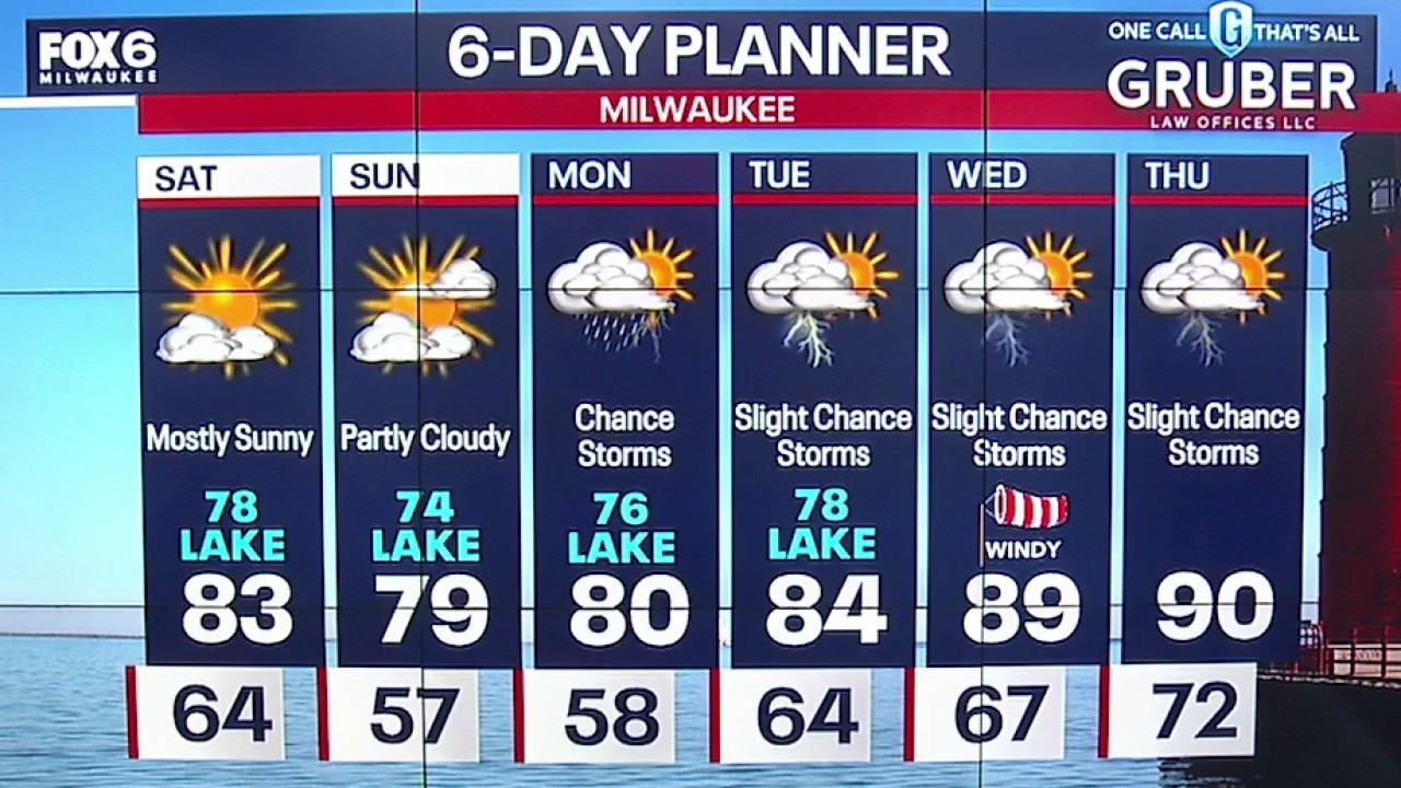
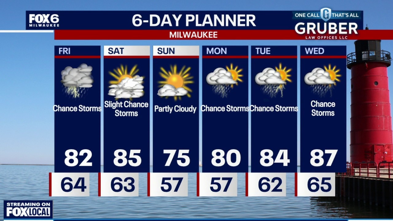
Thunderstorms are possible late tonight through early Saturday morning, then drying out the rest of the weekend. Temperatures will be cooler by the lake for a few days, then we really heat up late next week with our first potential 90! Storms are likely on Monday, then slight chances the rest of the week.
Thunderstorms are possible late tonight through early Saturday morning, then drying out the rest of the weekend. Temperatures will be cooler by the lake for a few days, then we really heat up late next week with our first potential 90! Storms are likely on Monday, then slight chances the rest of the week.
Weather webcast with Chief Meteorologist Rob Haswell
Southern Wisconsin is transitioning into a more humid and unsettled pattern, with rounds of showers and thunderstorms expected from through Friday night. The best chance of stronger storms arrives Friday evening.
Southern Wisconsin is transitioning into a more humid and unsettled pattern, with rounds of showers and thunderstorms expected from through Friday night. The best chance of stronger storms arrives Friday evening.
Weather webcast with Chief Meteorologist Rob Haswell
Southern Wisconsin is transitioning into a more humid and unsettled pattern, with rounds of showers and thunderstorms expected from through Friday night. The best chance of stronger storms arrives Friday evening, when enough instability could develop to support hail, gusty winds, and frequent lightning.
Southern Wisconsin is transitioning into a more humid and unsettled pattern, with rounds of showers and thunderstorms expected from through Friday night. The best chance of stronger storms arrives Friday evening, when enough instability could develop to support hail, gusty winds, and frequent lightning.
Weather Webcast with Chief Meteorologist Tom Wachs
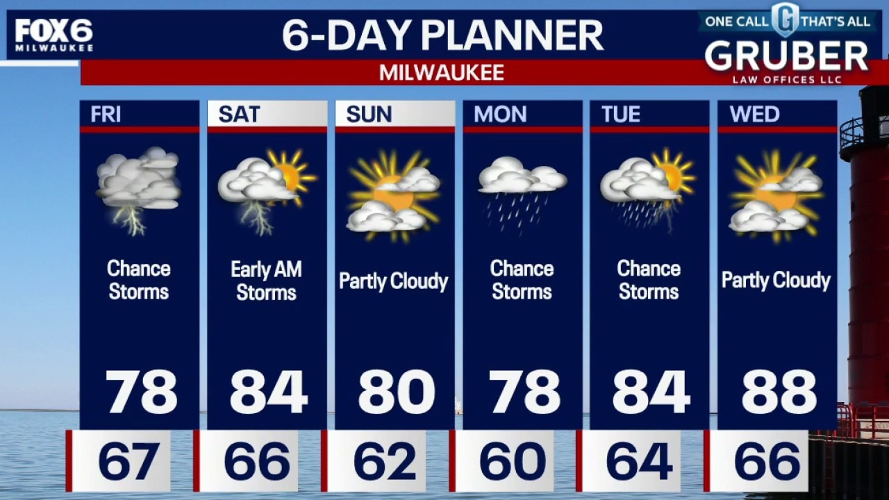
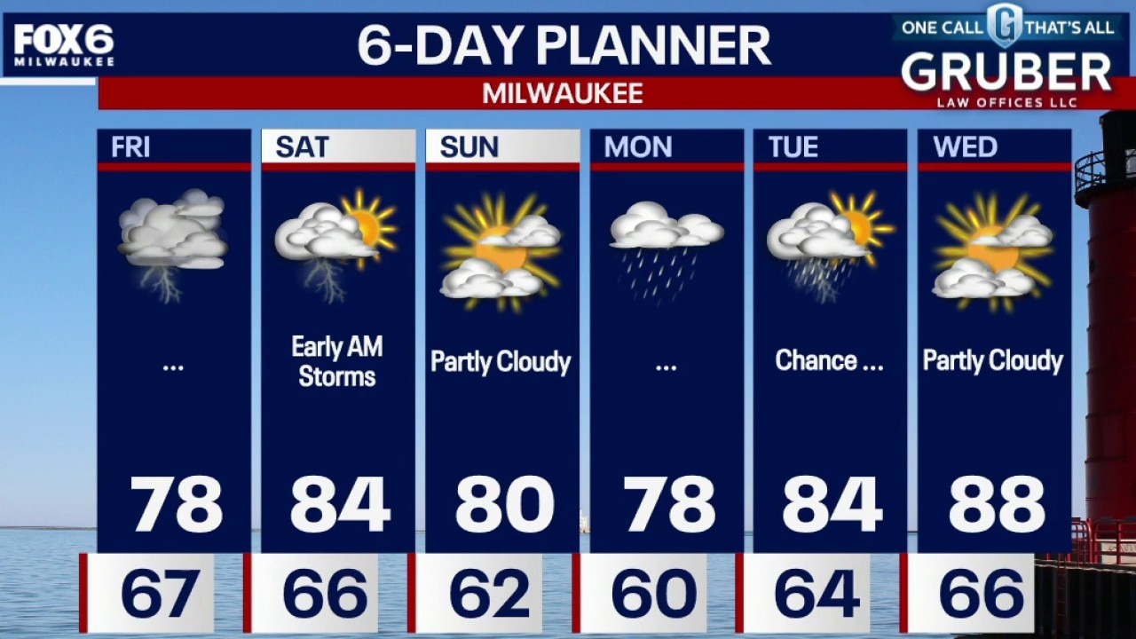
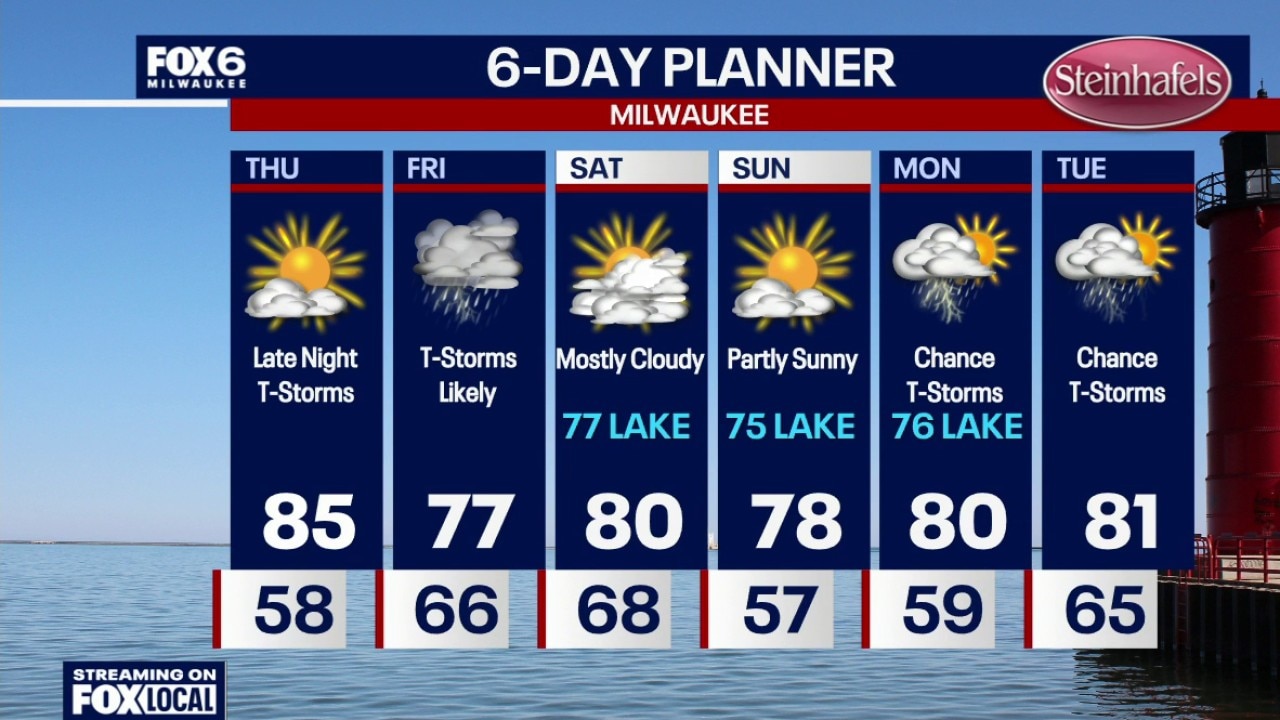
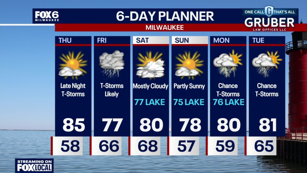
Increasing clouds overnight with temperatures settling in the upper 60s. Rainy on Friday morning with showers/t-storms. Heavy rain is possible (0.50"-1.0"). The heaviest rain will be in the morning, with scattered afternoon showers/t-storms. A few strong afternoon storms are possible with wind/hail.
Increasing clouds overnight with temperatures settling in the upper 60s. Rainy on Friday morning with showers/t-storms. Heavy rain is possible (0.50"-1.0"). The heaviest rain will be in the morning, with scattered afternoon showers/t-storms. A few strong afternoon storms are possible with wind/hail.
Weather Webcast with Chief Meteorologist Tom Wachs
Increasing clouds tonight with temperatures dropping through the 70s and settling in the upper 60s overnight. Rainy on Friday morning with showers/t-storms. Heavy rain is possible (0.50"-1.0"). The heaviest rain will be in the morning, with scattered afternoon showers/t-storms.
Increasing clouds tonight with temperatures dropping through the 70s and settling in the upper 60s overnight. Rainy on Friday morning with showers/t-storms. Heavy rain is possible (0.50"-1.0"). The heaviest rain will be in the morning, with scattered afternoon showers/t-storms.
Weather Webcast with Holly Baker
We are tracking a chance for storms tonight through Saturday.
We are tracking a chance for storms tonight through Saturday.
Weather webcast with meteorologist Holly Baker
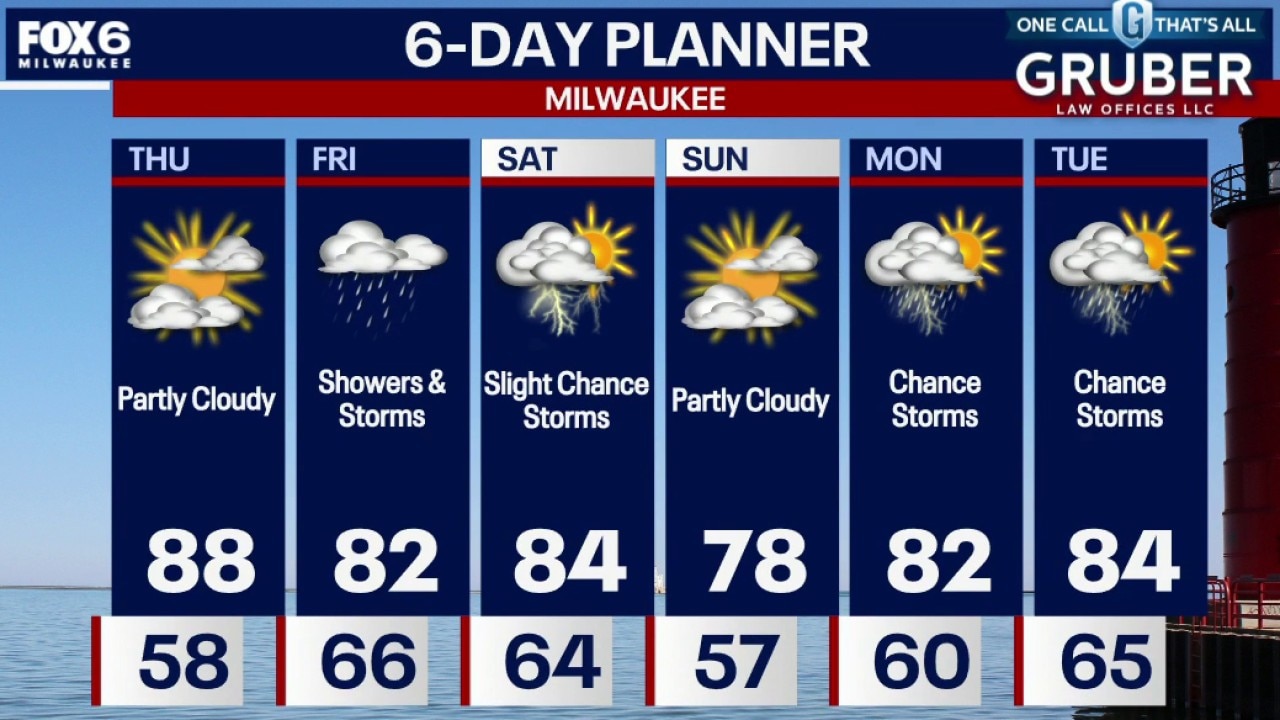
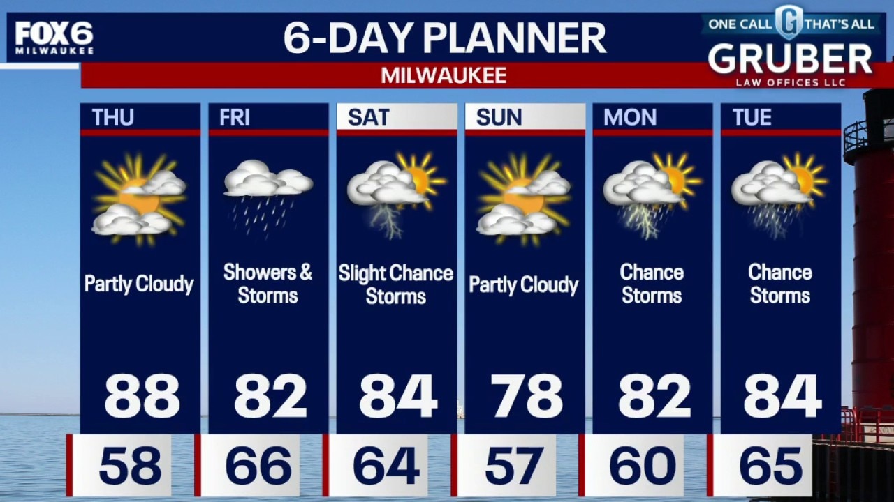
Highs climbing into the upper 80s today under breezy south-west winds. Thursday stays dry but increasing humidity will set the stage for multiple rounds of showers and thunderstorms from late Thursday night through Saturday.
Highs climbing into the upper 80s today under breezy south-west winds. Thursday stays dry but increasing humidity will set the stage for multiple rounds of showers and thunderstorms from late Thursday night through Saturday.
Weather webcast with Chief Meteorologist Rob Haswell
Summer is making a strong push into southern Wisconsin with highs climbing into the upper 80s today under breezy south-west winds.
Summer is making a strong push into southern Wisconsin with highs climbing into the upper 80s today under breezy south-west winds.
Weather Webcast with Chief Meteorologist Tom Wachs
Mostly clear overnight with temperatures falling into the upper 50s overnight. Partly sunny, breezy and warm on Thursday with highs in the mid-80s.
Mostly clear overnight with temperatures falling into the upper 50s overnight. Partly sunny, breezy and warm on Thursday with highs in the mid-80s.
Weather Webcast with Chief Meteorologist Tom Wachs
Air Quality Alert for Milwaukee, Ozaukee, Washington, Waukesha, Jefferson, Walworth, Racine and Kenosha Co. until 11pm.This is for "ground level ozone" meaning that folks with asthma, COPD or other respiratory illness should take it easy outdoors tonight. Expect more of these this summer with the warm weather.
Air Quality Alert for Milwaukee, Ozaukee, Washington, Waukesha, Jefferson, Walworth, Racine and Kenosha Co. until 11pm.This is for "ground level ozone" meaning that folks with asthma, COPD or other respiratory illness should take it easy outdoors tonight. Expect more of these this summer with the warm weather.
Weather webcast with Stephanie Barichello
Mostly sunny and warmer on Wednesday. Highs will be in the low 80s inland to upper 70s near the lake. Partly sunny with slightly stronger winds and warmer temps on Thursday. Highs in the middle 80s. Storms are possible late Thursday night with better coverages Friday into Saturday.
Mostly sunny and warmer on Wednesday. Highs will be in the low 80s inland to upper 70s near the lake. Partly sunny with slightly stronger winds and warmer temps on Thursday. Highs in the middle 80s. Storms are possible late Thursday night with better coverages Friday into Saturday.