


Weather webcast with Meteorologist Holly Baker
Thursday is shaping up to be another active weather day across southern Wisconsin, with the potential for significant severe storms from mid-afternoon into the early evening.
Thursday is shaping up to be another active weather day across southern Wisconsin, with the potential for significant severe storms from mid-afternoon into the early evening.


Severe weather threat Thursday: Tornadoes and damaging wind likely
Severe weather risks are increasing across southern Wisconsin today, with tornadoes, damaging winds, large hail, and flash flooding all possible this afternoon and evening.
Severe weather risks are increasing across southern Wisconsin today, with tornadoes, damaging winds, large hail, and flash flooding all possible this afternoon and evening.


Culver’s blue barn in Beaver Dam destroyed after storms
Strong storms on Wednesday left the iconic blue Culver’s barn in Beaver Dam severely damaged.
Strong storms on Wednesday left the iconic blue Culver’s barn in Beaver Dam severely damaged.

Weather webcast with Rob Haswell
Thursday is shaping up to be another active weather day across southern Wisconsin, with the potential for significant severe storms from mid-afternoon into the early evening.
Thursday is shaping up to be another active weather day across southern Wisconsin, with the potential for significant severe storms from mid-afternoon into the early evening.


Dodge County storm damage; roofs ripped off in Horicon, Lomira
Severe winds tore roofs from buildings in Horicon and Lomira on Wednesday, June 10, displacing renters, damaging homes and prompting a Red Cross shelter and Lomira reception center.
Severe winds tore roofs from buildings in Horicon and Lomira on Wednesday, June 10, displacing renters, damaging homes and prompting a Red Cross shelter and Lomira reception center.

Severe storms bring down trees in Mequon
Wednesday afternoon's storm also caused damage in Ozaukee County. In Mequon's Solar Heights neighborhood, several trees were toppled as storms moved through the area earlier in the day.
Wednesday afternoon's storm also caused damage in Ozaukee County. In Mequon's Solar Heights neighborhood, several trees were toppled as storms moved through the area earlier in the day.

Dodge County buildings damaged by afternoon storms
Severe winds tore roofs from buildings in Horicon and Lomira on Wednesday, June 10, displacing renters, damaging homes and prompting a Red Cross shelter and Lomira reception center.
Severe winds tore roofs from buildings in Horicon and Lomira on Wednesday, June 10, displacing renters, damaging homes and prompting a Red Cross shelter and Lomira reception center.
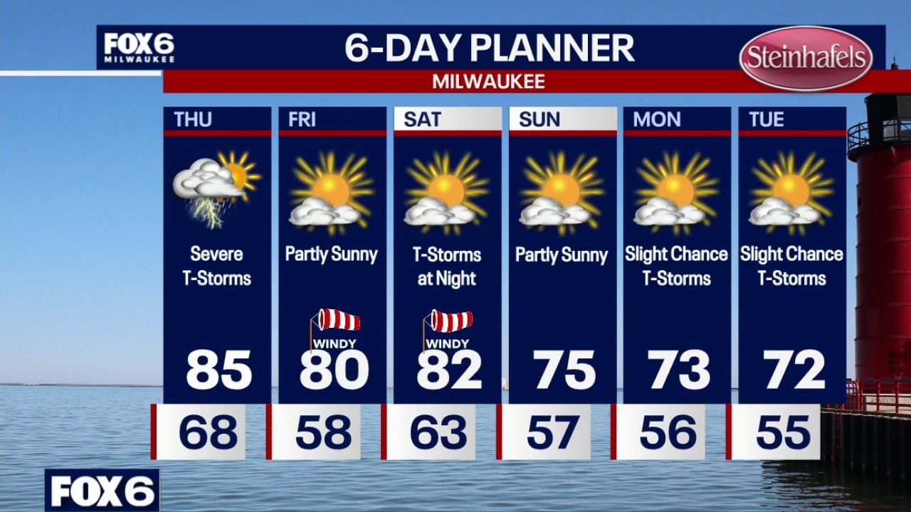
Weather Webcast with Chief Meteorologist Tom Wachs
There is a chance we could see more storms through 2am. Temperatures around 70 all night. Partly to mostly cloudy on Thursday. Severe t-storms. Midday severe t-storms are possible, but the worst of the storms will be 4pm-9pm. Tornadoes are expected along with very strong winds and large hail. Flooding is also possible. This is a volatile setup. It is imperative to stay weather aware and have sheltering plans.
There is a chance we could see more storms through 2am. Temperatures around 70 all night. Partly to mostly cloudy on Thursday. Severe t-storms. Midday severe t-storms are possible, but the worst of the storms will be 4pm-9pm. Tornadoes are expected along with very strong winds and large hail. Flooding is also possible. This is a volatile setup. It is imperative to stay weather aware and have sheltering plans.


Lightning strike starts Sheboygan fire, fire department says
A lightning strike started a house fire in Sheboygan during Wednesday's storms, the fire department said.
A lightning strike started a house fire in Sheboygan during Wednesday's storms, the fire department said.


Milwaukee Weather: More storms ahead
There is a chance we could see more storms through 2am. We are watching closely. Temperatures around 70 all night. Partly to mostly cloudy on Thursday. Severe t-storms. Midday severe t-storms are possible, but the worst of the storms will be 4pm-9pm. Tornadoes are expected along with very strong winds and large hail. Flooding is also possible. This is a volatile setup. It is imperative to stay weather aware and have sheltering plans.
There is a chance we could see more storms through 2am. We are watching closely. Temperatures around 70 all night. Partly to mostly cloudy on Thursday. Severe t-storms. Midday severe t-storms are possible, but the worst of the storms will be 4pm-9pm. Tornadoes are expected along with very strong winds and large hail. Flooding is also possible. This is a volatile setup. It is imperative to stay weather aware and have sheltering plans.
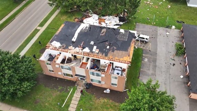

Horicon, Lomira see significant storm damage
The FOX6 Weather Experts are tracking severe weather that has the potential to impact all of southeast Wisconsin on Wednesday, June 10. While not everyone will see severe weather, any storm that develops could become strong quickly. Thunderstorms, damaging wind, large hail and isolated tornadoes are possible. Those threats remain possible into Wednesday night before a brief lull develops. Another round is expected Thursday.
The FOX6 Weather Experts are tracking severe weather that has the potential to impact all of southeast Wisconsin on Wednesday, June 10. While not everyone will see severe weather, any storm that develops could become strong quickly. Thunderstorms, damaging wind, large hail and isolated tornadoes are possible. Those threats remain possible into Wednesday night before a brief lull develops. Another round is expected Thursday.
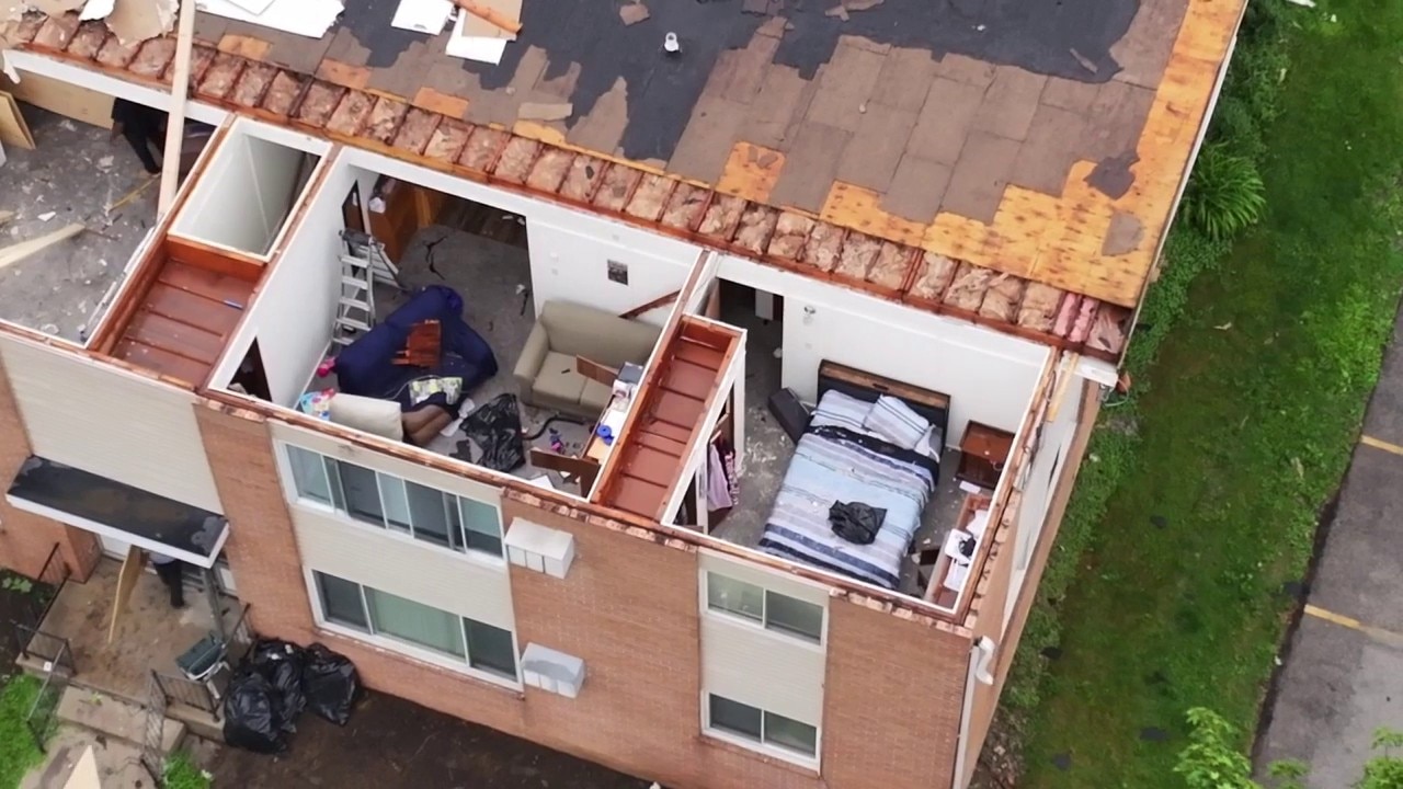
Storm damage in Lomira, Wisconsin
SKYFOX shows you damage to an apartment building in Lomira, Wisconsin.
SKYFOX shows you damage to an apartment building in Lomira, Wisconsin.
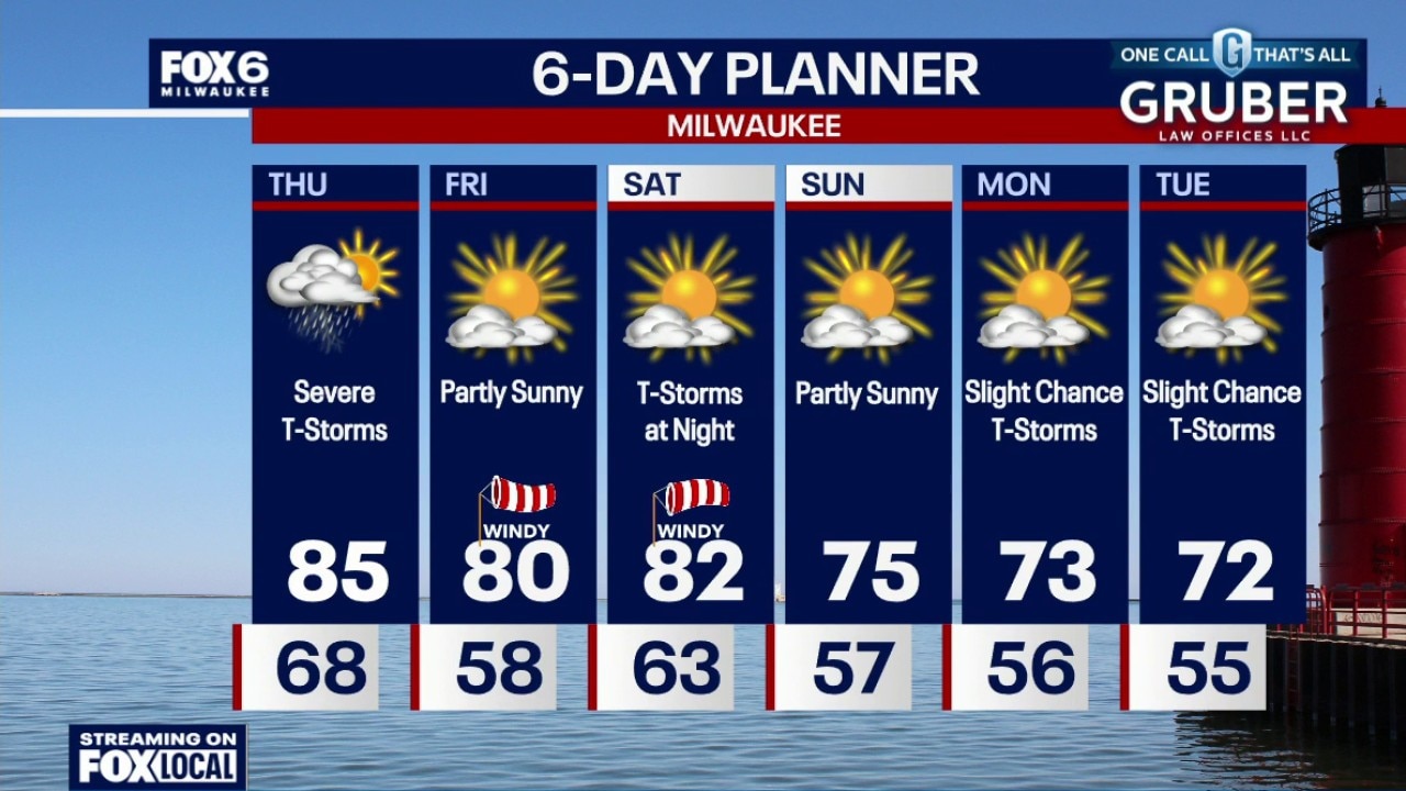
Weather Webcast with Chief Meteorologist Tom Wachs
There is a chance we could see more storms through 2am. We are watching closely. Temperatures around 70 all night. Partly to mostly cloudy on Thursday. Severe t-storms. Midday severe t-storms are possible, but the worst of the storms will be 4pm-9pm. Tornadoes are expected along with very strong winds and large hail. Flooding is also possible. This is a volatile setup. It is imperative to stay weather aware and have sheltering plans.
There is a chance we could see more storms through 2am. We are watching closely. Temperatures around 70 all night. Partly to mostly cloudy on Thursday. Severe t-storms. Midday severe t-storms are possible, but the worst of the storms will be 4pm-9pm. Tornadoes are expected along with very strong winds and large hail. Flooding is also possible. This is a volatile setup. It is imperative to stay weather aware and have sheltering plans.

Horicon storm damage; buildings hit in downtown area
The FOX6 News team takes you to communities in southeast Wisconsin that suffered damage from a line of severe weather that blew through on Wednesday, June 10.
The FOX6 News team takes you to communities in southeast Wisconsin that suffered damage from a line of severe weather that blew through on Wednesday, June 10.

Horicon roof blown off captured by women in area
FOX6 News viewer Kelly O. shared video from Horicon that appears to show a roof blowing away after it was ripped off a building on Wednesday, June 10. She and a friend spoke with FOX6 News.
FOX6 News viewer Kelly O. shared video from Horicon that appears to show a roof blowing away after it was ripped off a building on Wednesday, June 10. She and a friend spoke with FOX6 News.
Heavy rain enters Milwaukee County
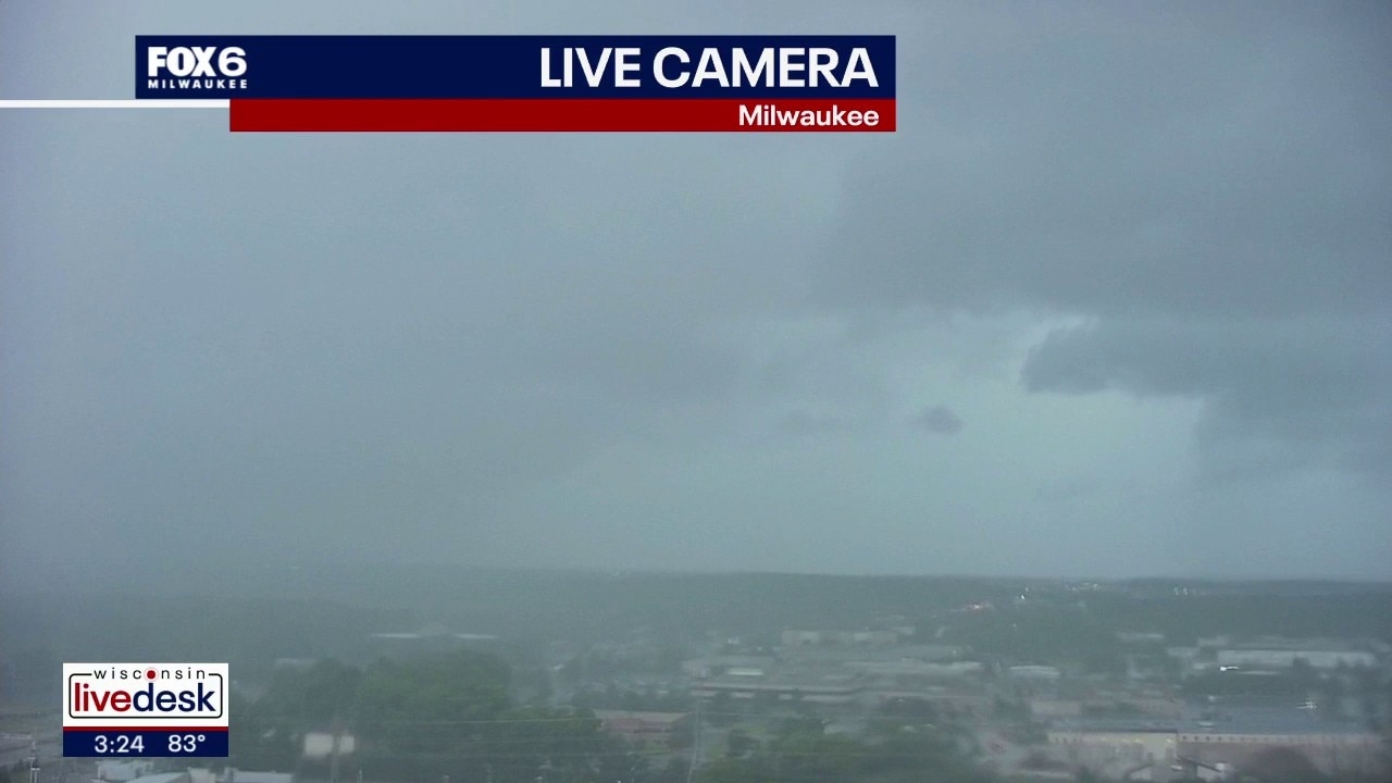
A FOX6 News tower camera captured a wall of heavy rain entering Milwaukee County on Wednesday afternoon, June 10.
A FOX6 News tower camera captured a wall of heavy rain entering Milwaukee County on Wednesday afternoon, June 10.

Southeast Wisconsin severe thunderstorm watch Wednesday; what to expect
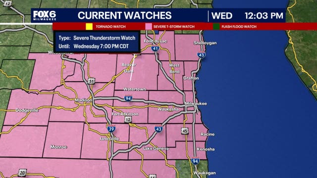
After a muggy start to Wednesday, the atmosphere will become increasingly unstable through the afternoon, setting the stage for thunderstorms capable of damaging winds, large hail, and perhaps a few isolated tornadoes.
After a muggy start to Wednesday, the atmosphere will become increasingly unstable through the afternoon, setting the stage for thunderstorms capable of damaging winds, large hail, and perhaps a few isolated tornadoes.
Weather webcast with Stephanie Barichello
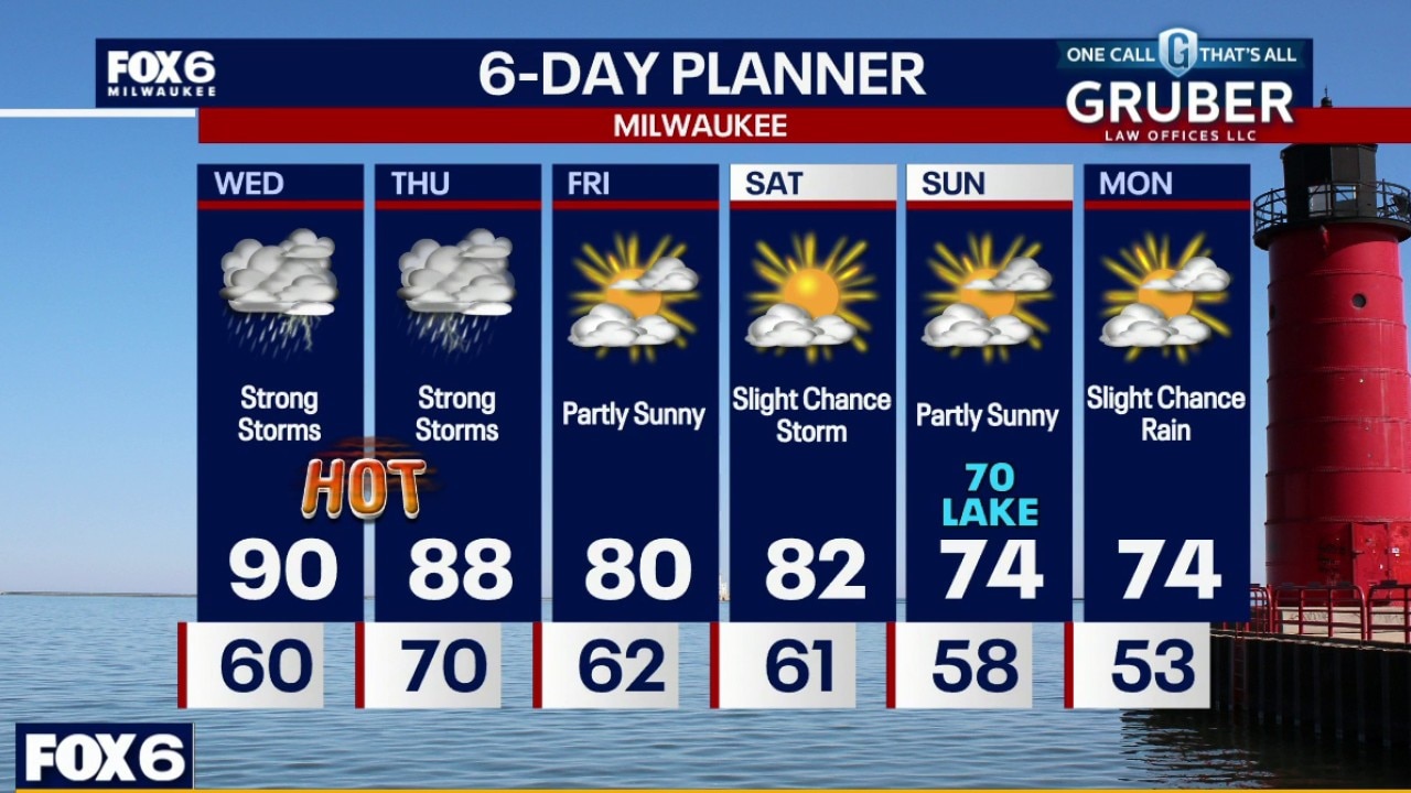
Breezy, hot and humid on Wednesday with highs near 90F and an afternoon heat index around 100. A round of severe t-storms is likely between 1pm-6pm on Wednesday with tornadoes, wind and hail possible.
Breezy, hot and humid on Wednesday with highs near 90F and an afternoon heat index around 100. A round of severe t-storms is likely between 1pm-6pm on Wednesday with tornadoes, wind and hail possible.
Weather webcast with Lisa Michaels
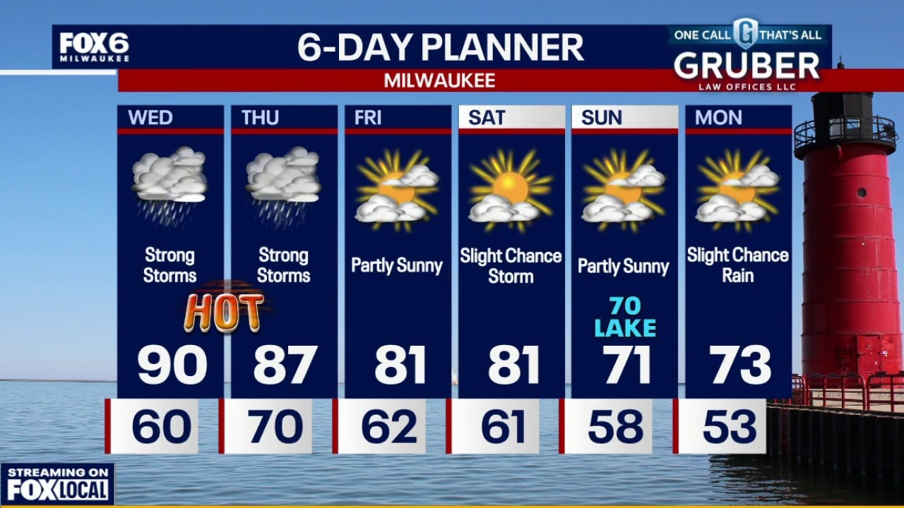
Dense fog advisory until 7am for counties closer to the lake. Windy, hot and humid on Wednesday with highs near 90F and an afternoon heat index around 100.
Dense fog advisory until 7am for counties closer to the lake. Windy, hot and humid on Wednesday with highs near 90F and an afternoon heat index around 100.
Weather Webcast with Chief Meteorologist Tom Wachs
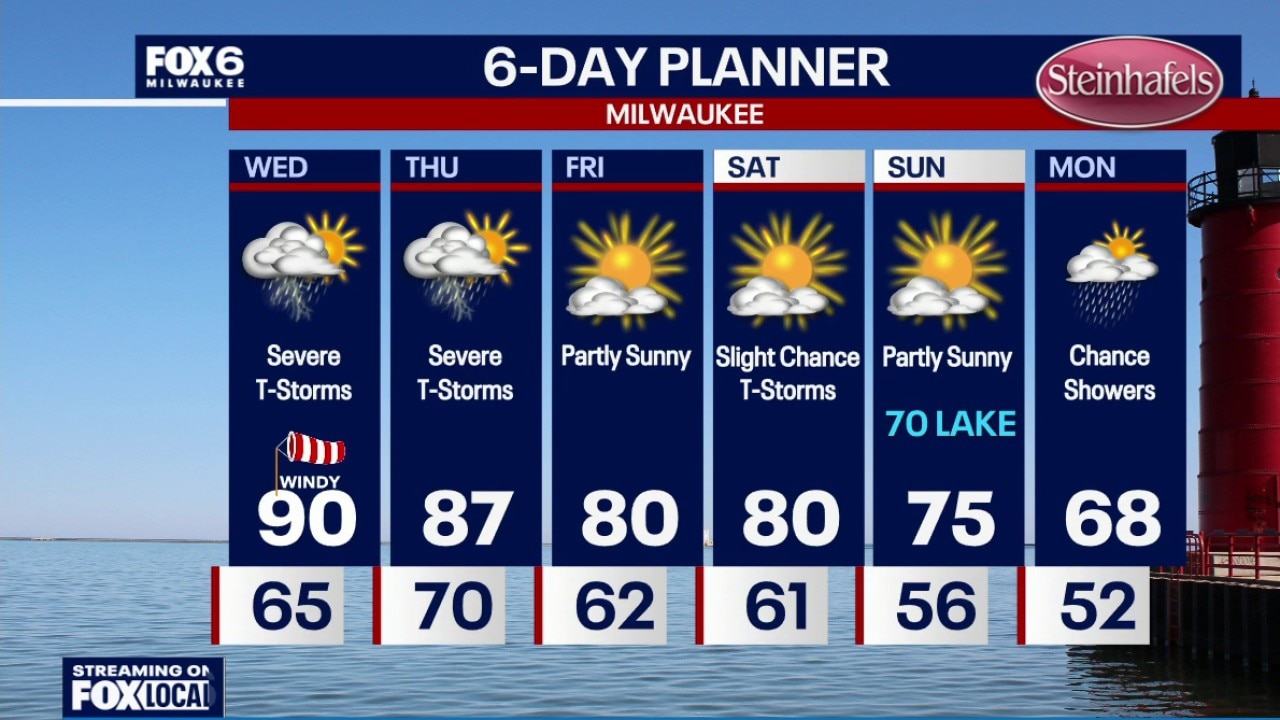
Dense fog overnight with temperatures dropping into the 60s. Slim chance for t-storms on Wednesday morning, but chances are going down. Windy, hot and humid on Wednesday with an afternoon heat index around 100. A round of severe t-storms is likely between 11am-5pm on Wednesday with tornadoes, wind and hail possible. A second round is expected between 7pm-2am with all threats again on the table.
Dense fog overnight with temperatures dropping into the 60s. Slim chance for t-storms on Wednesday morning, but chances are going down. Windy, hot and humid on Wednesday with an afternoon heat index around 100. A round of severe t-storms is likely between 11am-5pm on Wednesday with tornadoes, wind and hail possible. A second round is expected between 7pm-2am with all threats again on the table.