

Weather Webcast with Chief Meteorologist Tom Wachs
Cloudy and foggy tonight with a few light rain showers overnight. Temperatures hovering around 40. Cloudy with spotty light rain showers and drizzle on Monday with a mild high in the mid-to-upper 40s.
Cloudy and foggy tonight with a few light rain showers overnight. Temperatures hovering around 40. Cloudy with spotty light rain showers and drizzle on Monday with a mild high in the mid-to-upper 40s.

Weather webcast with Lisa Michaels
A misty and foggy Sunday transitioning to cloudy by the afternoon. Highs remain in the low 40s. There is a slight chance for a few light showers late Sunday into early Monday morning. Otherwise, mild with highs remaining in the low to mid 40s for the start of next week.
A misty and foggy Sunday transitioning to cloudy by the afternoon. Highs remain in the low 40s. There is a slight chance for a few light showers late Sunday into early Monday morning. Otherwise, mild with highs remaining in the low to mid 40s for the start of next week.

Webcast Weather with Holly Baker
A wintry mix will be transitioning into rain tonight.
A wintry mix will be transitioning into rain tonight.
Weather webcast with Lisa Michaels
A winter weather advisory is in effect from 3PM Saturday to midnight Sunday. A wintry mix and rain could lead to slippery/icy roads. Not looking to be a problem near the lake due to warmer temps.
A winter weather advisory is in effect from 3PM Saturday to midnight Sunday. A wintry mix and rain could lead to slippery/icy roads. Not looking to be a problem near the lake due to warmer temps.

Weather Webcast with Holly Baker
A wintry mix and warm up in temperatures is expected over the weekend.
A wintry mix and warm up in temperatures is expected over the weekend.
Weather webcast with Rob Haswell
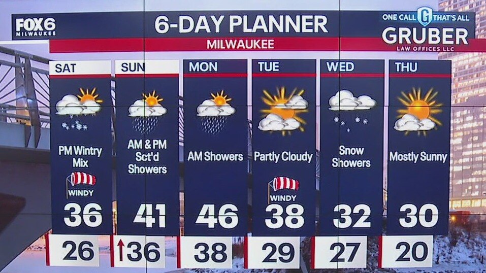
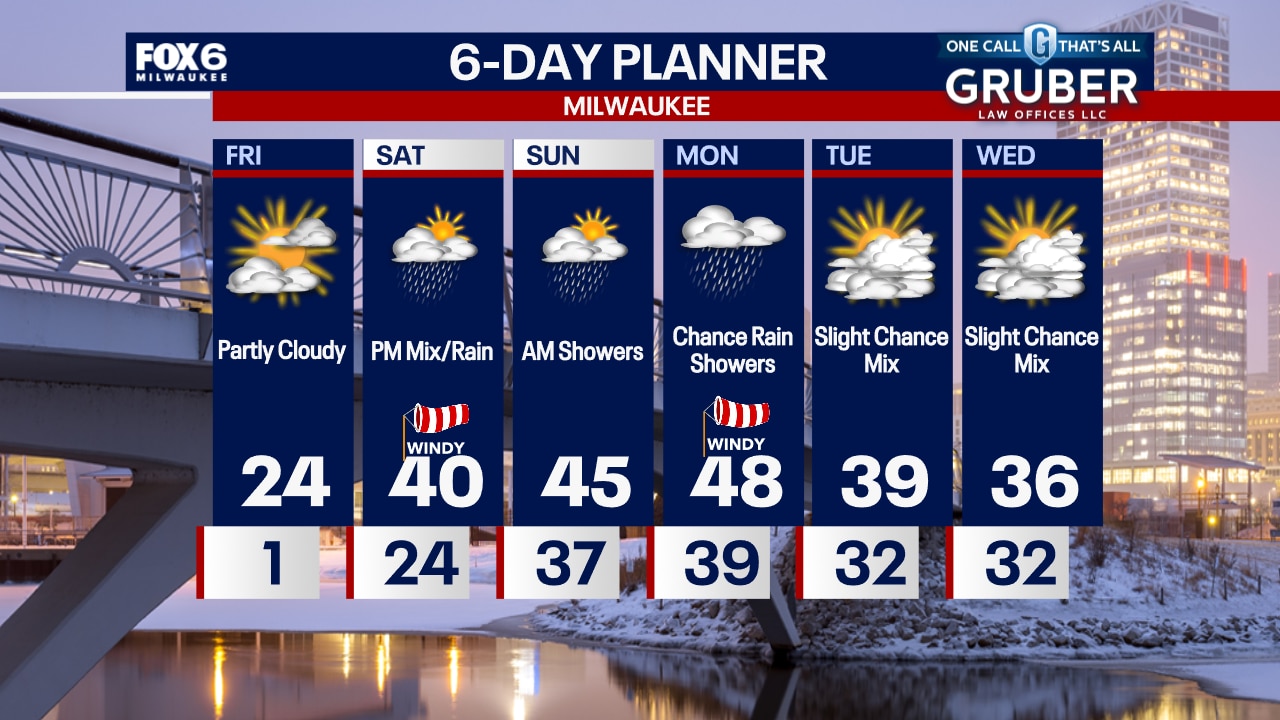
We start a slow but steady warm up today with highs reaching the low to mid 20s by late in the day. After a clear start, we get cloudy but stay dry until later in the day on Saturday. With warming temperatures, we are likely to see all rain Saturday but there is a risk for some wintry mix. More rain early Sunday then a break before yet more rain Sunday night into Monday. We should dry up Tuesday and Wednesday. We become very mild for the weekend and Monday but return to near seasonal values on Tuesday and Wednesday.
We start a slow but steady warm up today with highs reaching the low to mid 20s by late in the day. After a clear start, we get cloudy but stay dry until later in the day on Saturday. With warming temperatures, we are likely to see all rain Saturday but there is a risk for some wintry mix. More rain early Sunday then a break before yet more rain Sunday night into Monday. We should dry up Tuesday and Wednesday. We become very mild for the weekend and Monday but return to near seasonal values on Tuesday and Wednesday.
Weather Webcast with Chief Meteorologist Tom Wachs
Clear and cold overnight with wind chills between -5 and -15. Partly sunny on Friday with afternoon highs in the mid-20s. Temperatures will rise on Friday night. Our next chance for rain/mix is late in the day on Saturday with a high around 40.
Clear and cold overnight with wind chills between -5 and -15. Partly sunny on Friday with afternoon highs in the mid-20s. Temperatures will rise on Friday night. Our next chance for rain/mix is late in the day on Saturday with a high around 40.
Weather Webcast with Chief Meteorologist Tom Wachs
Cold again tonight with wind chills of -5 to -15 into Friday morning. Partly cloudy and "warmer" on Friday afternoon with highs in the 20s. Warming up even more Friday night. Rain chances return Saturday afternoon.
Cold again tonight with wind chills of -5 to -15 into Friday morning. Partly cloudy and "warmer" on Friday afternoon with highs in the 20s. Warming up even more Friday night. Rain chances return Saturday afternoon.
Weather Webcast with Stephanie Barichello
Cold today with some clouds at times, then clearing tonight with lows in the single digits just above or below 0. 20s on Friday, then we jump into the 40s over the weekend. Rain is looking likely, especially Saturday afternoon and evening into Sunday morning.
Cold today with some clouds at times, then clearing tonight with lows in the single digits just above or below 0. 20s on Friday, then we jump into the 40s over the weekend. Rain is looking likely, especially Saturday afternoon and evening into Sunday morning.
Weather webcast with Rob Haswell
Bitterly cold Arctic air has descended upon our area. A Cold Weather Advisory is in place until 10am. Wind chills will be in the -15 to -25 range for the morning and stay sub-zero through the afternoon. We will be sunny all day and clear overnight but clouds return Friday. We warm up and get wet for Saturday and we stay mild through early next week.
Bitterly cold Arctic air has descended upon our area. A Cold Weather Advisory is in place until 10am. Wind chills will be in the -15 to -25 range for the morning and stay sub-zero through the afternoon. We will be sunny all day and clear overnight but clouds return Friday. We warm up and get wet for Saturday and we stay mild through early next week.
Weather Webcast with Chief Meteorologist Tom Wachs
Cold Weather Advisory until 10am Thursday. AM Wind Chills -20 to -25, Afternoon Wind Chill around -4. Mostly sunny, windy and bitter cold on Thursday.
Cold Weather Advisory until 10am Thursday. AM Wind Chills -20 to -25, Afternoon Wind Chill around -4. Mostly sunny, windy and bitter cold on Thursday.
Weather Webcast with Chief Meteorologist Tom Wachs
Cold Weather Advisory 10pm Tonight until 10am Thursday. Wind chills dropping to -20 to -25 by morning. Skies will clear out with lots of sun on Thursday. Bitterly cold with windy conditions, especially in the morning. Wind chills below 0 all day.
Cold Weather Advisory 10pm Tonight until 10am Thursday. Wind chills dropping to -20 to -25 by morning. Skies will clear out with lots of sun on Thursday. Bitterly cold with windy conditions, especially in the morning. Wind chills below 0 all day.
Weather webcast with Rob Haswell
A few flurries this morning with a few more snow showers later today. Highs will be near 30 today but much colder air arrives later today and we fall to near zero overnight. Wind speeds ramp up later today with gusts exceeding 30mph creating wind chills in the -10 to -20 range overnight into Thursday morning. Sunny and cold Thursday but we warm up Friday and into the weekend.
A few flurries this morning with a few more snow showers later today. Highs will be near 30 today but much colder air arrives later today and we fall to near zero overnight. Wind speeds ramp up later today with gusts exceeding 30mph creating wind chills in the -10 to -20 range overnight into Thursday morning. Sunny and cold Thursday but we warm up Friday and into the weekend.

Weather Webcast with Chief Meteorologist Tom Wachs
Flurries possible overnight with temperatures in the 20s. Scattered snow showers on Wednesday, becoming windy with temperatures in the 20s. Wind chills around +15 all day. Colder on Thursday.
Flurries possible overnight with temperatures in the 20s. Scattered snow showers on Wednesday, becoming windy with temperatures in the 20s. Wind chills around +15 all day. Colder on Thursday.
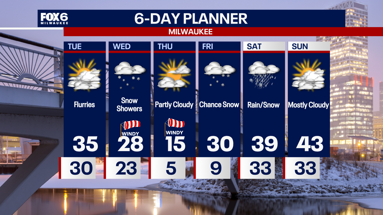
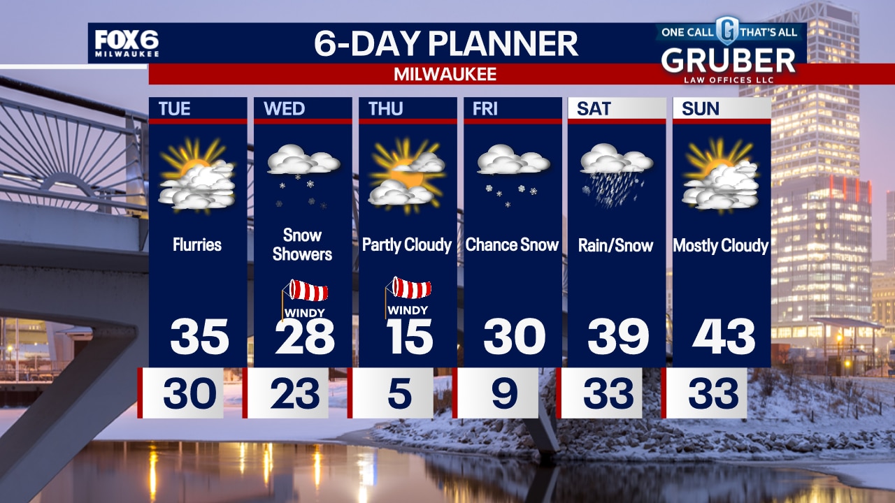
Weather Webcast with Chief Meteorologist Tom Wachs
Cloudy with a few flurries tonight and temperatures in the 20s. The wind will pick up during the day on Wednesday with scattered snow showers. Highs in the 20s with wind chills in the teens.
Cloudy with a few flurries tonight and temperatures in the 20s. The wind will pick up during the day on Wednesday with scattered snow showers. Highs in the 20s with wind chills in the teens.
Weather webcast with Rob Haswell
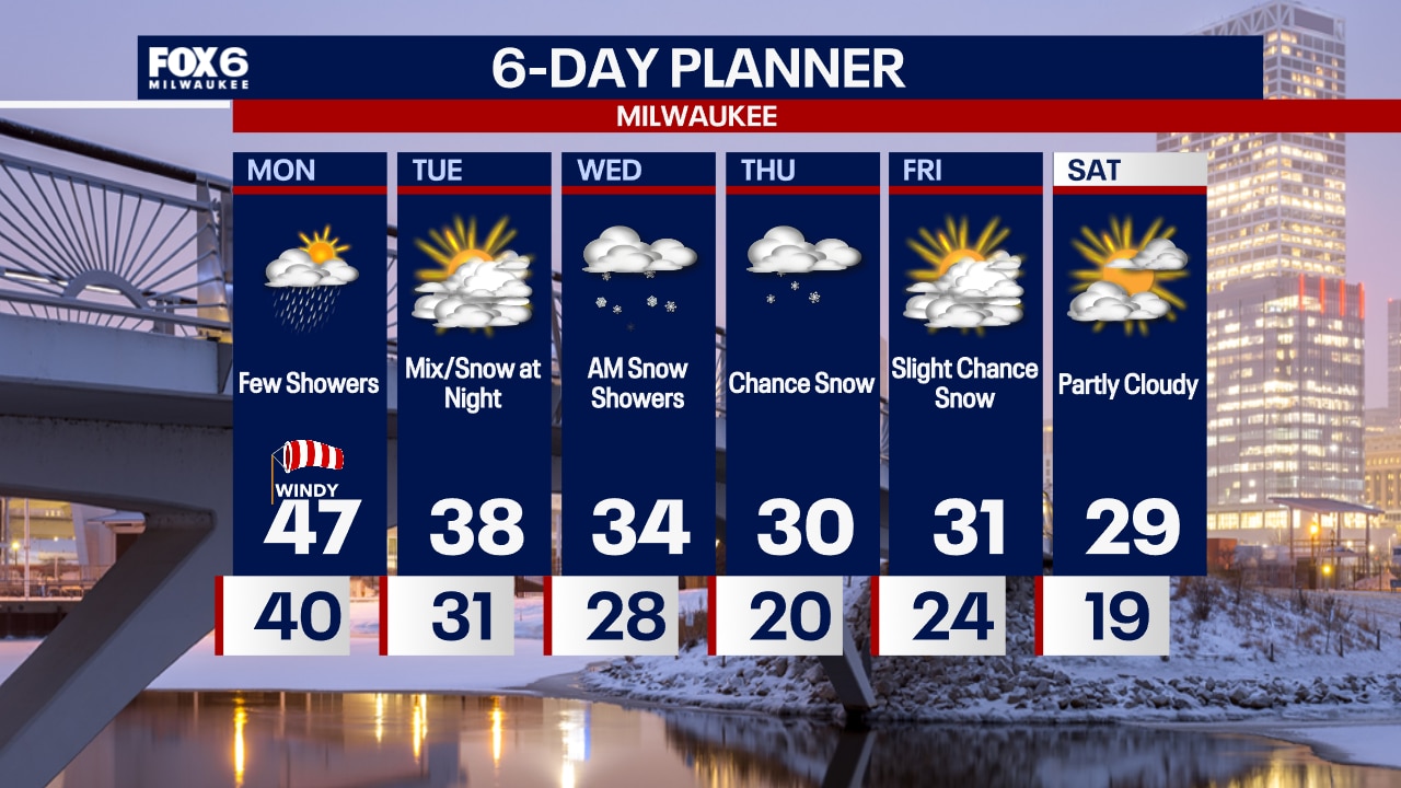
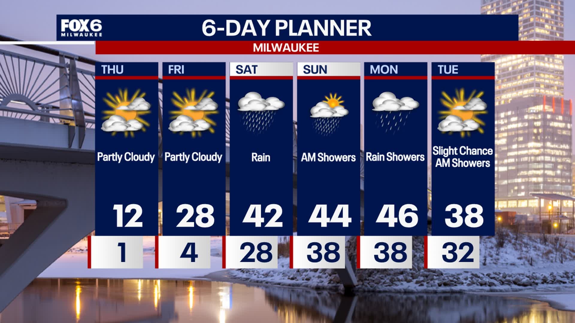
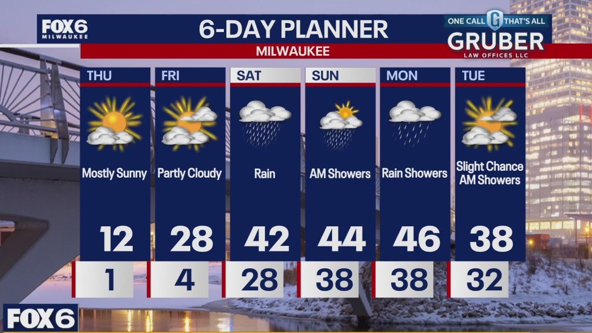
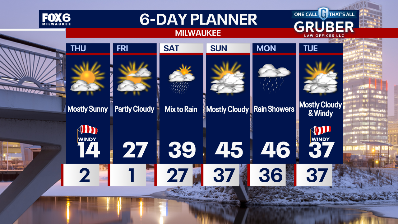
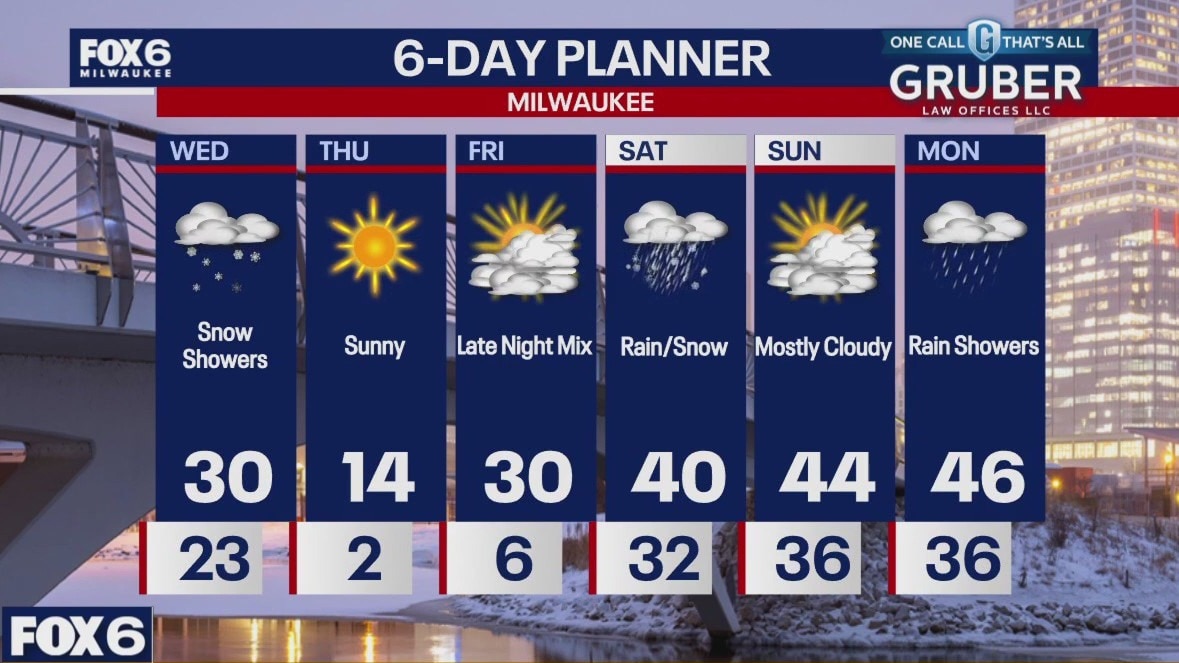
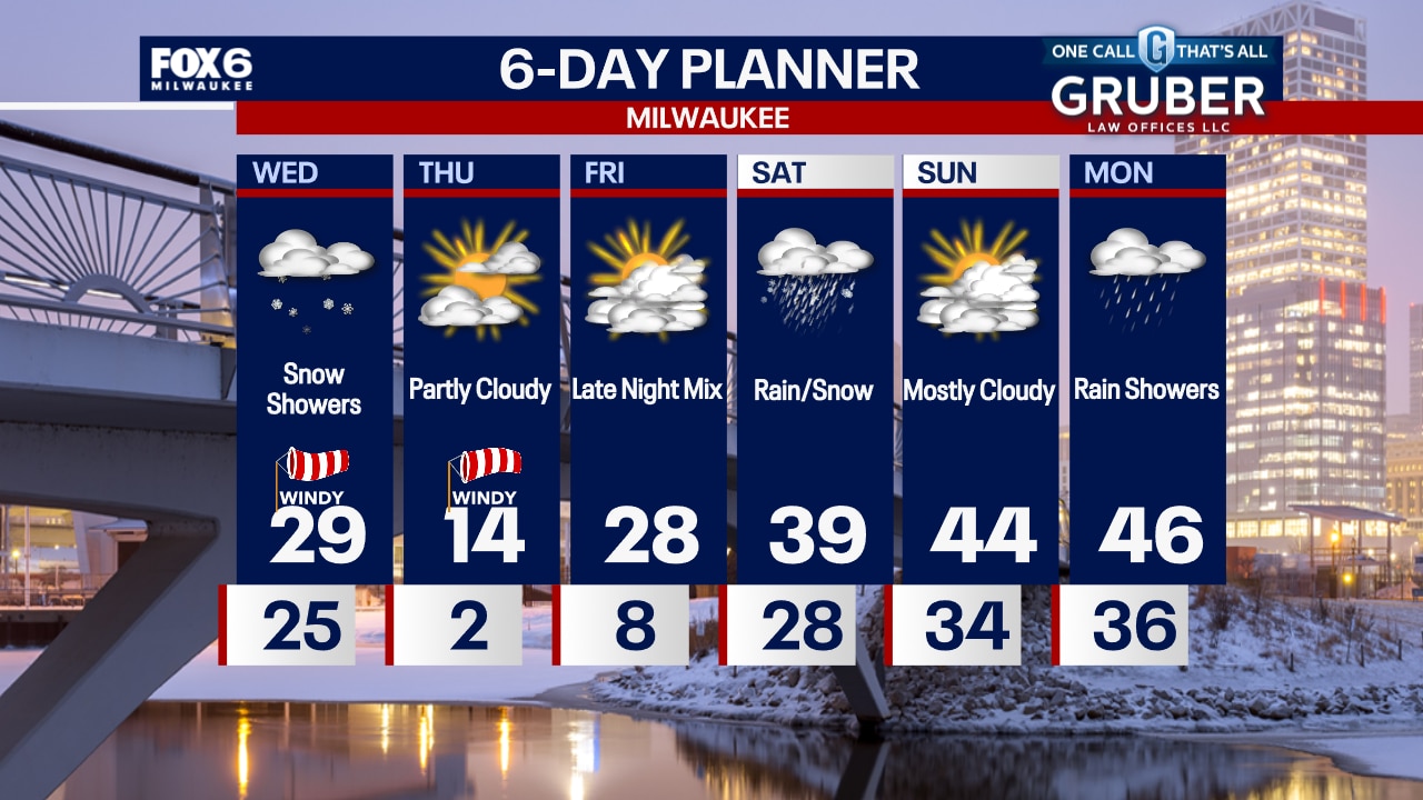
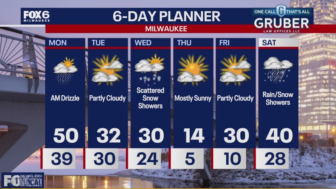
Colder air starts to take over today with highs returning to the mid and upper 30s but even cold air arrives later this week. We will be mostly cloudy but dry today with a light NW breeze. Snow returns to the forecast tomorrow along with a strong NW wind. The coldest air of the season will arrive Wednesday night into Thursday. Lows will fall to near zero Wednesday night and highs on Thursday will struggle to reach the low teens. More snow is in the forecast for Friday with a chance for rain and snow on Saturday as we warm up for the weekend.
Colder air starts to take over today with highs returning to the mid and upper 30s but even cold air arrives later this week. We will be mostly cloudy but dry today with a light NW breeze. Snow returns to the forecast tomorrow along with a strong NW wind. The coldest air of the season will arrive Wednesday night into Thursday. Lows will fall to near zero Wednesday night and highs on Thursday will struggle to reach the low teens. More snow is in the forecast for Friday with a chance for rain and snow on Saturday as we warm up for the weekend.
Weather Webcast with Chief Meteorologist Tom Wachs
Increasing clouds overnight with temperatures in the upper 20s to around 30 by sunrise. Mostly cloudy, blustery and cooler on Tuesday with a few afternoon flurries. High temperatures in the low-to-mid-30s.
Increasing clouds overnight with temperatures in the upper 20s to around 30 by sunrise. Mostly cloudy, blustery and cooler on Tuesday with a few afternoon flurries. High temperatures in the low-to-mid-30s.
Weather Webcast with Chief Meteorologist Tom Wachs
Increasing clouds and breezy tonight with temperatures dropping into the 30s. Mostly cloudy on Tuesday with afternoon flurries. Breezy with highs in the mid-30s. Cold and windy on Wednesday with a few snow showers.
Increasing clouds and breezy tonight with temperatures dropping into the 30s. Mostly cloudy on Tuesday with afternoon flurries. Breezy with highs in the mid-30s. Cold and windy on Wednesday with a few snow showers.
Weather webcast with Rob Haswell
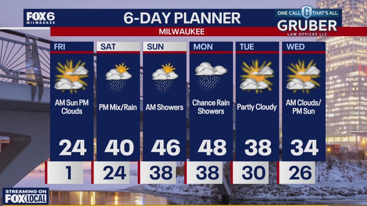
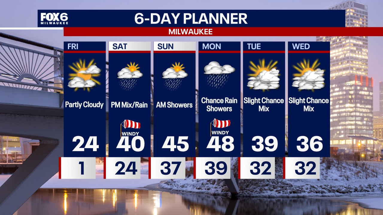
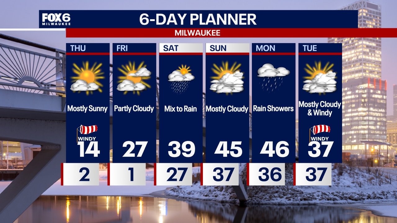
One more mild day before a chill returns behind a cold front. Highs today will reach 50 again. The much colder Arctic air takes over starting Tuesday and we continue to cool through the work week. Highs will fall to the low 30s Tuesday and Wednesday and dip to the teens by Thursday. A warm up is likely by the weekend.
One more mild day before a chill returns behind a cold front. Highs today will reach 50 again. The much colder Arctic air takes over starting Tuesday and we continue to cool through the work week. Highs will fall to the low 30s Tuesday and Wednesday and dip to the teens by Thursday. A warm up is likely by the weekend.

Webcast Weather with Holly Baker
Temperatures remain mild through Monday before polar air arrives.
Temperatures remain mild through Monday before polar air arrives.