


Milwaukee power outages Tuesday, wind damage after storm
Thousands of people across the Milwaukee area were left without power after wind gusts toppled trees and power lines on Monday.
Thousands of people across the Milwaukee area were left without power after wind gusts toppled trees and power lines on Monday.


Milwaukee Weather: Drying up Tuesday, cooling down late week
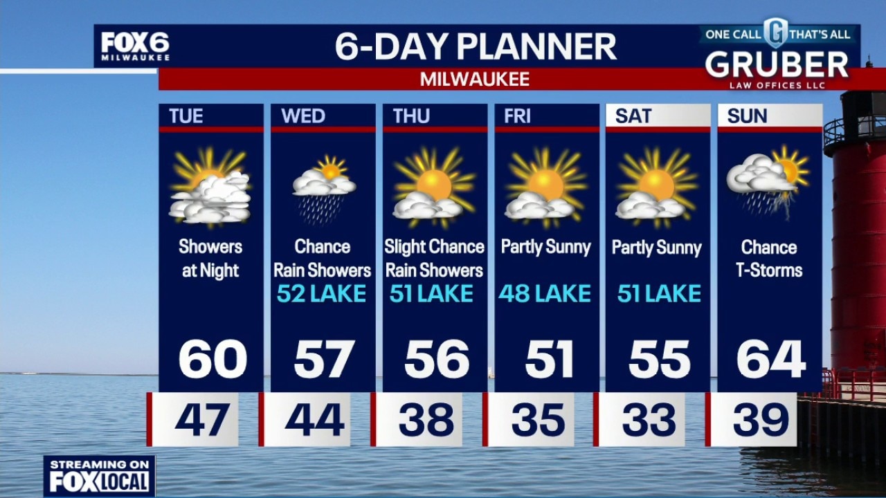
The cold front that brought Monday's storms has pushed out, and anything leftover is fading quickly as the atmosphere stabilizes. In its wake, a cooler pattern takes over with temperatures running below average through much of the week.
The cold front that brought Monday's storms has pushed out, and anything leftover is fading quickly as the atmosphere stabilizes. In its wake, a cooler pattern takes over with temperatures running below average through much of the week.
Milwaukee Weather: Wind damage earlier, few storms tonight
A 77mph wind gust was reported at MKE airport at 1:32pm Monday on the back side of rain showers. This caused power outages and tree damage around the city. The severe risk is LOW tonight, but not zero. Isolated t-storms ending overnight. Temperatures dropping into the 40s. Mostly cloudy and breezy on Tuesday with a high around 60. Rain showers Tuesday night into Wednesday and a slight chance on Thursday. Highs in the 50s mid-to-late week.
A 77mph wind gust was reported at MKE airport at 1:32pm Monday on the back side of rain showers. This caused power outages and tree damage around the city. The severe risk is LOW tonight, but not zero. Isolated t-storms ending overnight. Temperatures dropping into the 40s. Mostly cloudy and breezy on Tuesday with a high around 60. Rain showers Tuesday night into Wednesday and a slight chance on Thursday. Highs in the 50s mid-to-late week.
Weather Webcast with Chief Meteorologist Tom Wachs
A 77mph wind gust was reported at MKE airport at 1:32pm Monday on the back side of rain showers. This caused power outages and tree damage around the city. The severe risk is LOW tonight, but not zero. Isolated t-storms are possible until around midnight. This threat has really dropped from earlier forecasts. Widespread heavy rain is also no longer expected. The greatest threat shifted south. Temperatures will drop from the 50s into the 40s overnight.
A 77mph wind gust was reported at MKE airport at 1:32pm Monday on the back side of rain showers. This caused power outages and tree damage around the city. The severe risk is LOW tonight, but not zero. Isolated t-storms are possible until around midnight. This threat has really dropped from earlier forecasts. Widespread heavy rain is also no longer expected. The greatest threat shifted south. Temperatures will drop from the 50s into the 40s overnight.

Wind gusts topple trees in Milwaukee's Riverwest neighborhood
Extremely powerful wind gusts caused havoc throughout southeast Wisconsin, downing trees and knocking out power to thousands. FOX6's Ashley Sears shows you the damage in Milwaukee's Riverwest neighborhood.
Extremely powerful wind gusts caused havoc throughout southeast Wisconsin, downing trees and knocking out power to thousands. FOX6's Ashley Sears shows you the damage in Milwaukee's Riverwest neighborhood.


Wind gusts slam SE Wisconsin; power knocked out, trees toppled
Extremely powerful wind gusts barreled through southeast Wisconsin on Monday afternoon, April 27, and knocked out power for thousands.
Extremely powerful wind gusts barreled through southeast Wisconsin on Monday afternoon, April 27, and knocked out power for thousands.


Southeast Wisconsin weather: Severe storms, heavy rain possible Monday
The Storm Prediction Center has issued most of southeast Wisconsin under a slight risk for severe storms on Monday.
The Storm Prediction Center has issued most of southeast Wisconsin under a slight risk for severe storms on Monday.

Weather webcast with Chief Meteorologist Rob Haswell
A few morning showers or sprinkles are possible, followed by a midday break that could actually help fuel stronger storms this evening. The better chance for impactful weather comes late afternoon into early evening, where a line of storms could bring gusty winds and maybe a quick spin-up.
A few morning showers or sprinkles are possible, followed by a midday break that could actually help fuel stronger storms this evening. The better chance for impactful weather comes late afternoon into early evening, where a line of storms could bring gusty winds and maybe a quick spin-up.

Weather Webcast with Chief Meteorologist Tom Wachs
Areas of fog tonight, especially near the lake, with temperatures in the 40s. 2 rounds of rain on Monday. The first is from 8am-2pm with 0.50" of rain. No severe weather expected out of that, but a few rumbles possible. Highs in the upper 50s to mid-60s on Monday afternoon. Round 2 will be a round of strong t-storms between 6pm-12am.
Areas of fog tonight, especially near the lake, with temperatures in the 40s. 2 rounds of rain on Monday. The first is from 8am-2pm with 0.50" of rain. No severe weather expected out of that, but a few rumbles possible. Highs in the upper 50s to mid-60s on Monday afternoon. Round 2 will be a round of strong t-storms between 6pm-12am.
Milwaukee Weather: AM rain on Monday, strong night storms
Areas of fog overnight, especially near the lake, with temperatures in the 40s. 2 rounds of rain on Monday. The first is from 8am-2pm with around 0.50" of rain. No severe weather expected out of that, but a few rumbles possible. Highs in the upper 50s to mid-60s on Monday afternoon. Round 2 will be a round of strong t-storms between 6pm-12am. Heavy rain, strong winds, hail and isolated tornadoes (west/SW of MKE) possible.
Areas of fog overnight, especially near the lake, with temperatures in the 40s. 2 rounds of rain on Monday. The first is from 8am-2pm with around 0.50" of rain. No severe weather expected out of that, but a few rumbles possible. Highs in the upper 50s to mid-60s on Monday afternoon. Round 2 will be a round of strong t-storms between 6pm-12am. Heavy rain, strong winds, hail and isolated tornadoes (west/SW of MKE) possible.

Weather Webcast with Chief Meteorologist Tom Wachs
Mostly cloudy tonight and breezy with temperatures in the 40s. 2 rounds of rain on Monday. The first is from 8am-1pm with around 0.25" of rain. No severe weather expected out of that, but a few rumbles possible. Highs in the upper 50s to mid-60s on Monday afternoon. Round 2 will be a round of strong t-storms between 6pm-12am.
Mostly cloudy tonight and breezy with temperatures in the 40s. 2 rounds of rain on Monday. The first is from 8am-1pm with around 0.25" of rain. No severe weather expected out of that, but a few rumbles possible. Highs in the upper 50s to mid-60s on Monday afternoon. Round 2 will be a round of strong t-storms between 6pm-12am.

Weather webcast with meteorologist Lisa Michaels
Mostly sunny Sunday with high temperatures in the mid to upper 50s lakeside to low 60s inland. Clouds increase Sunday night into Monday morning. Rain is likely early Monday.
Mostly sunny Sunday with high temperatures in the mid to upper 50s lakeside to low 60s inland. Clouds increase Sunday night into Monday morning. Rain is likely early Monday.

Weather Webcast with Holly Baker
Sunday will be partly sunny with highs in the 50s to 60s.
Sunday will be partly sunny with highs in the 50s to 60s.


Milwaukee County tornado sirens, upgrade to how alerts are sounded
Milwaukee County officials said new technology will improve its tornado sirens, providing a major upgrade to how it sounds emergency alerts.
Milwaukee County officials said new technology will improve its tornado sirens, providing a major upgrade to how it sounds emergency alerts.

Weather webcast with meteorologist Lisa Michaels
Clouds in the morning that will decrease on Saturday. Partly sunny skies by the afternoon with highs in the low 60s inland to upper 50s near the lake. The forecast on Sunday is similar with mostly sunny skies. Highs in the low 60s inland to upper 50s near the lake
Clouds in the morning that will decrease on Saturday. Partly sunny skies by the afternoon with highs in the low 60s inland to upper 50s near the lake. The forecast on Sunday is similar with mostly sunny skies. Highs in the low 60s inland to upper 50s near the lake
Milwaukee Weather: Decreasing clouds, mild temps but cooler near the lake
Clouds in the morning that will decrease on Saturday. Partly sunny skies by the afternoon with highs in the low 60s inland to upper 50s near the lake.
Clouds in the morning that will decrease on Saturday. Partly sunny skies by the afternoon with highs in the low 60s inland to upper 50s near the lake.

Weather Webcast with Holly Baker
A high pressure system keeps SE Wisconsin dry over the weekend.
A high pressure system keeps SE Wisconsin dry over the weekend.

Wisconsin Weather Experts: Temperatures cool down
The Wisconsin Weather Experts at FOX6 News Milwaukee share weather forecast trends and much more.
The Wisconsin Weather Experts at FOX6 News Milwaukee share weather forecast trends and much more.


Waterford flooding, some areas still dealing with high water
A week after heavy rain fell across southeast Wisconsin, parts of Waterford are still dealing with floods.
A week after heavy rain fell across southeast Wisconsin, parts of Waterford are still dealing with floods.

Weather webcast with Rob Haswell
A few more storms rolling through early Friday morning but things are trending downward as they move into a less favorable environment.
A few more storms rolling through early Friday morning but things are trending downward as they move into a less favorable environment.