

Weather webcast with Stephanie Barichello
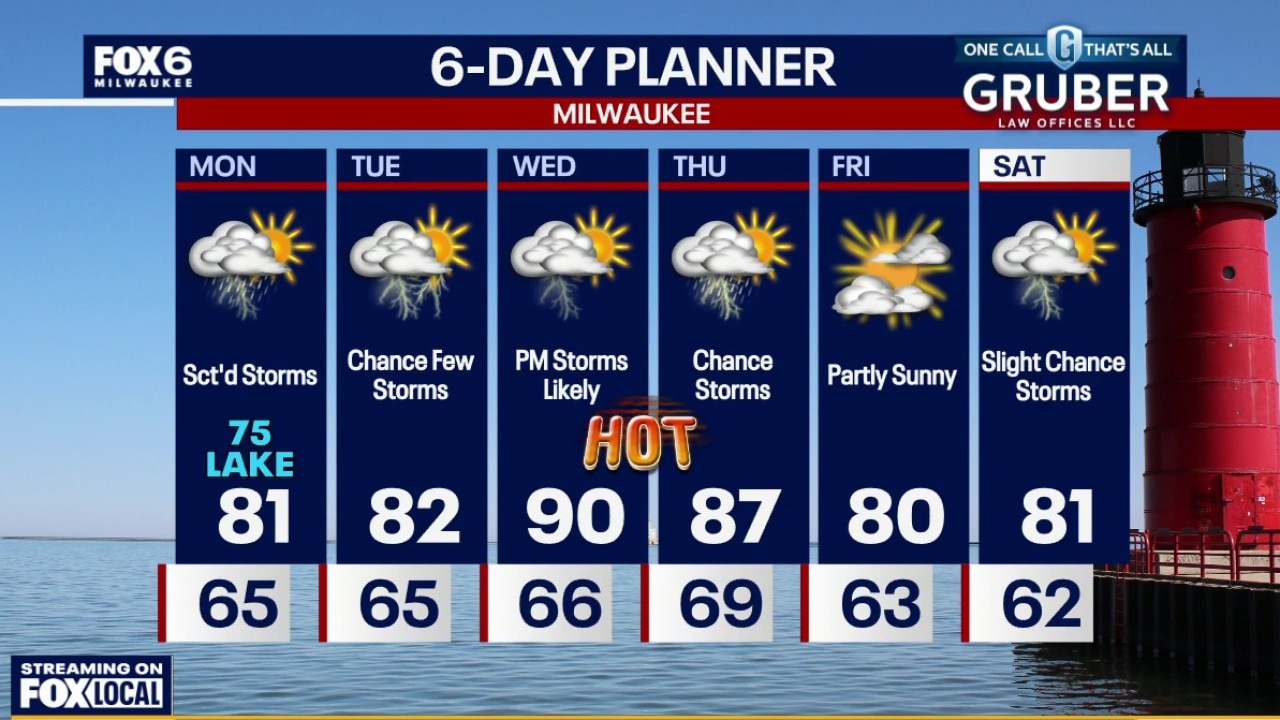
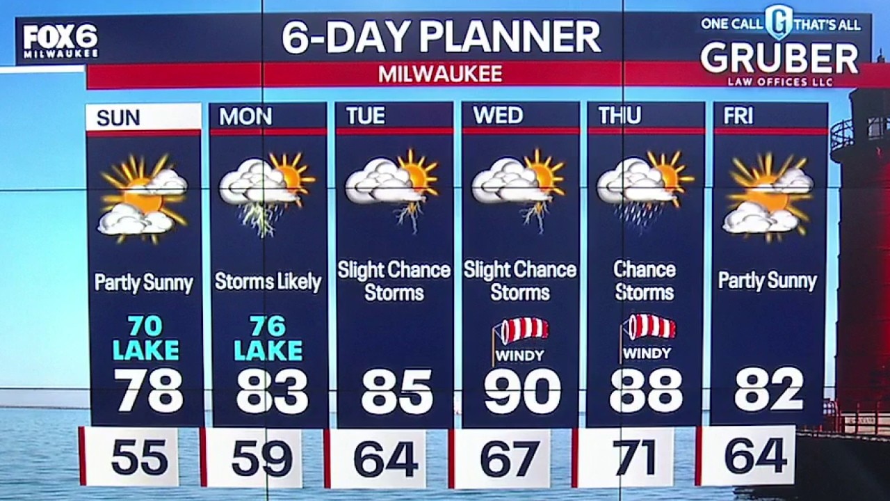
A few early morning showers and isolated non-severe storms. Muggy. Warming up into the low 80s inland and mid-70s near the lake on Monday.
A few early morning showers and isolated non-severe storms. Muggy. Warming up into the low 80s inland and mid-70s near the lake on Monday.

Southeast Wisconsin weather: High heat, humidity and storms return
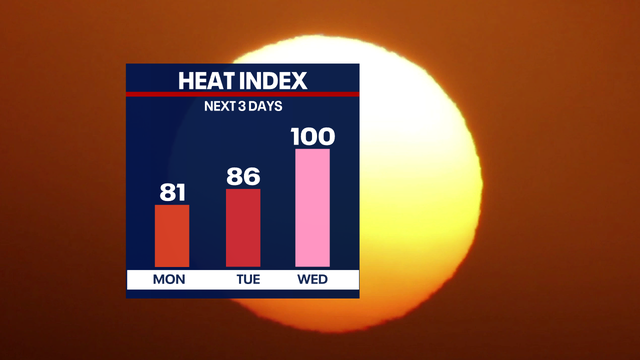
A major heat risk for all of southeast Wisconsin on Wednesday impacts everyone as uncommon high temperatures and dew points will be present.
A major heat risk for all of southeast Wisconsin on Wednesday impacts everyone as uncommon high temperatures and dew points will be present.
Weather webcast with Lisa Michaels
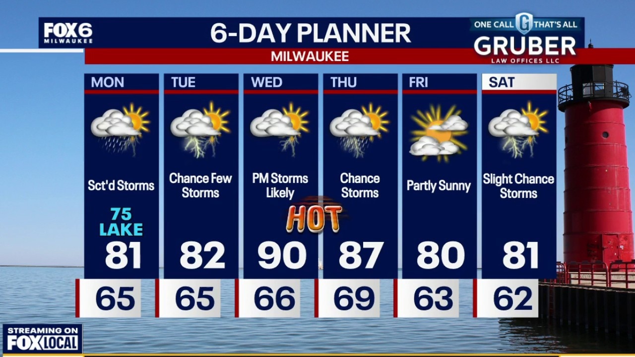
A few early morning showers and isolated non-severe storms. Muggy. Warming up into the low 80s inland and mid-70s near the lake on Monday. Scattered rain and storms pick-up during the afternoon and evening.
A few early morning showers and isolated non-severe storms. Muggy. Warming up into the low 80s inland and mid-70s near the lake on Monday. Scattered rain and storms pick-up during the afternoon and evening.


Milwaukee Weather: T-Storms on Monday
An isolated t-storm is possible overnight with temperatures in the 60s. Only a slight chance for a t-storm during the day on Monday, with greater chances late in the afternoon into the evening. Humid with a high around 80 inland, 75 near the lake.
An isolated t-storm is possible overnight with temperatures in the 60s. Only a slight chance for a t-storm during the day on Monday, with greater chances late in the afternoon into the evening. Humid with a high around 80 inland, 75 near the lake.
Weather Webcast with Chief Meteorologist Tom Wachs
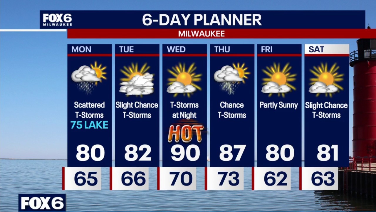
A few t-storms are possible this evening and overnight with temperatures dropping through the 60s. We have a soggy day on the way Monday, but not all day rains. Scattered t-storms likely, steadiest in the afternoon/early evening. Humid with a high around 80.
A few t-storms are possible this evening and overnight with temperatures dropping through the 60s. We have a soggy day on the way Monday, but not all day rains. Scattered t-storms likely, steadiest in the afternoon/early evening. Humid with a high around 80.
Weather webcast with meteorologist Lisa Michaels
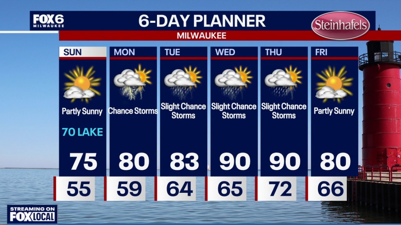
Partly sunny Sunday and the most comfortable day of the week! Highs in the upper 70s inland to low 70s near the lake with lower dew points. Waves of energy will increase the chances for rain and storms on Monday morning and afternoon.
Partly sunny Sunday and the most comfortable day of the week! Highs in the upper 70s inland to low 70s near the lake with lower dew points. Waves of energy will increase the chances for rain and storms on Monday morning and afternoon.
Weather Webcast with Holly Baker
Another partly sunny day is expected for Sunday!
Another partly sunny day is expected for Sunday!
Weather webcast with Meteorologist Lisa Michaels
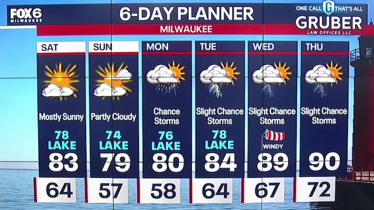
Isolated early fog. Partly cloudy in the morning to mostly sunny in the day. Highs in the upper 70s lakeside to low 80s inland and sticky. Partly cloudy Saturday night with lows in the mid to upper 50s. Patchy fog possible into Sunday morning.
Isolated early fog. Partly cloudy in the morning to mostly sunny in the day. Highs in the upper 70s lakeside to low 80s inland and sticky. Partly cloudy Saturday night with lows in the mid to upper 50s. Patchy fog possible into Sunday morning.
Milwaukee Weather: Mostly sunny and sticky Saturday
Isolated early fog. Partly cloudy in the morning to mostly sunny in the day. Highs in the upper 70s lakeside to low 80s inland and sticky.
Isolated early fog. Partly cloudy in the morning to mostly sunny in the day. Highs in the upper 70s lakeside to low 80s inland and sticky.
Weather Webcast with Holly Baker
We are tracking rain tonight and sunshine tomorrow.
We are tracking rain tonight and sunshine tomorrow.


Tornado warnings expire for Dodge, Fond du Lac counties
The National Weather Service and FOX6 Weather Experts tracked severe weather in southeast Wisconsin on Friday night.
The National Weather Service and FOX6 Weather Experts tracked severe weather in southeast Wisconsin on Friday night.
Weather Webcast with Stephanie Barichello
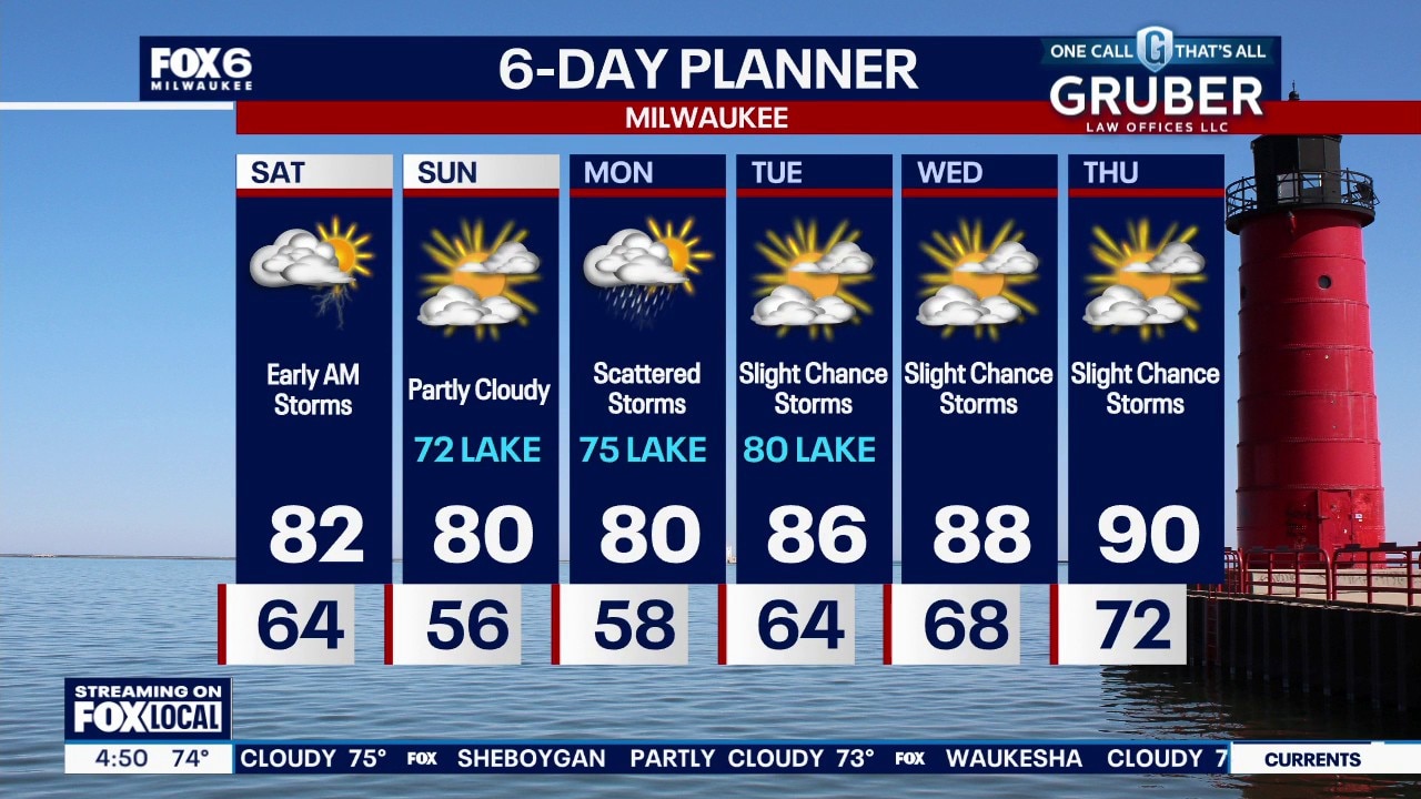
Thunderstorms are possible late tonight through early Saturday morning, then drying out the rest of the weekend. Temperatures will be cooler by the lake for a few days, then we really heat up late next week with our first potential 90! Storms are likely on Monday, then slight chances the rest of the week.
Thunderstorms are possible late tonight through early Saturday morning, then drying out the rest of the weekend. Temperatures will be cooler by the lake for a few days, then we really heat up late next week with our first potential 90! Storms are likely on Monday, then slight chances the rest of the week.

Wildfires are reversing years of progress on US ozone pollution, study finds
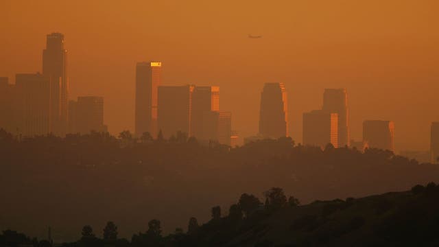
New research shows that increasingly intense wildfires are making the U.S. smoggier again.
New research shows that increasingly intense wildfires are making the U.S. smoggier again.
Milwaukee Weather: Scattered storms through Saturday morning
Isolated to scattered showers and thunderstorms possible this evening, with another cluster of storms possible overnight. A strong to severe thunderstorm cannot be ruled out with gusty wind and hail.
Isolated to scattered showers and thunderstorms possible this evening, with another cluster of storms possible overnight. A strong to severe thunderstorm cannot be ruled out with gusty wind and hail.
Weather webcast with Chief Meteorologist Rob Haswell
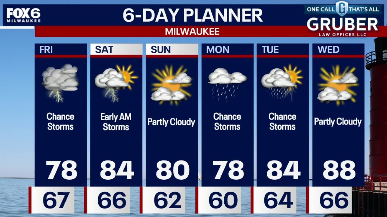
Southern Wisconsin is transitioning into a more humid and unsettled pattern, with rounds of showers and thunderstorms expected from through Friday night. The best chance of stronger storms arrives Friday evening.
Southern Wisconsin is transitioning into a more humid and unsettled pattern, with rounds of showers and thunderstorms expected from through Friday night. The best chance of stronger storms arrives Friday evening.
Weather webcast with Chief Meteorologist Rob Haswell
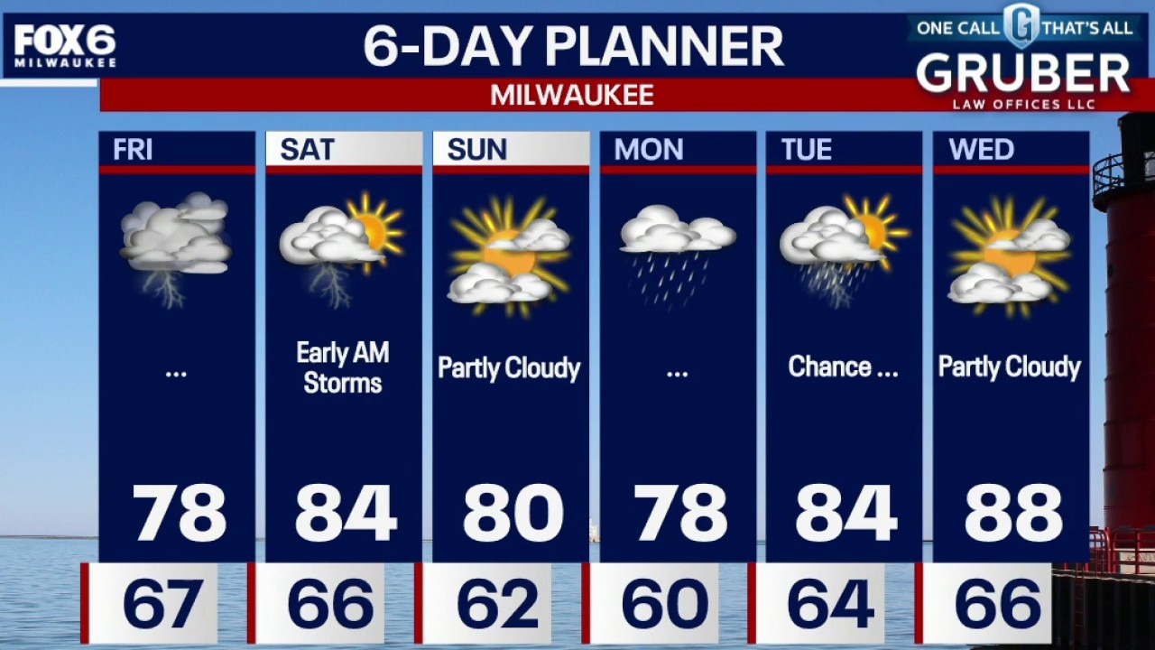
Southern Wisconsin is transitioning into a more humid and unsettled pattern, with rounds of showers and thunderstorms expected from through Friday night. The best chance of stronger storms arrives Friday evening, when enough instability could develop to support hail, gusty winds, and frequent lightning.
Southern Wisconsin is transitioning into a more humid and unsettled pattern, with rounds of showers and thunderstorms expected from through Friday night. The best chance of stronger storms arrives Friday evening, when enough instability could develop to support hail, gusty winds, and frequent lightning.
Weather Webcast with Chief Meteorologist Tom Wachs
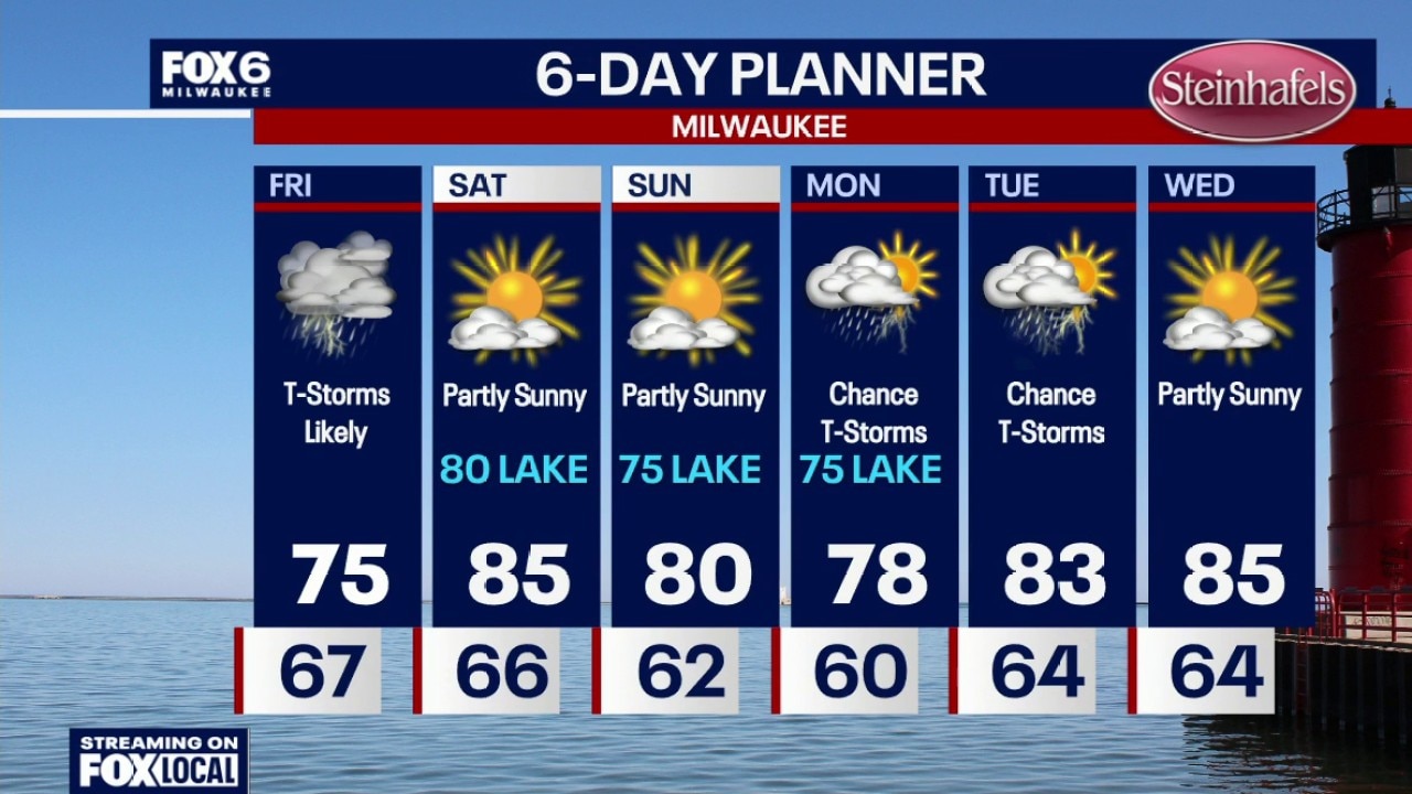
Increasing clouds overnight with temperatures settling in the upper 60s. Rainy on Friday morning with showers/t-storms. Heavy rain is possible (0.50"-1.0"). The heaviest rain will be in the morning, with scattered afternoon showers/t-storms. A few strong afternoon storms are possible with wind/hail.
Increasing clouds overnight with temperatures settling in the upper 60s. Rainy on Friday morning with showers/t-storms. Heavy rain is possible (0.50"-1.0"). The heaviest rain will be in the morning, with scattered afternoon showers/t-storms. A few strong afternoon storms are possible with wind/hail.
Milwaukee Weather: Warm, windy and dry
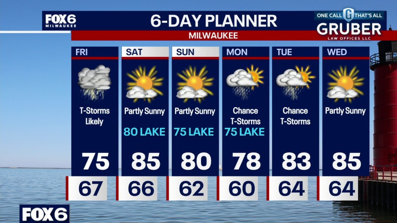
Increasing clouds overnight with temperatures settling in the upper 60s. Rainy on Friday morning with showers/t-storms. Heavy rain is possible (0.50"-1.0"). The heaviest rain will be in the morning, with scattered afternoon showers/t-storms. A few strong afternoon storms are possible with wind/hail. Highs in the mid-70s on Friday with the rain around. A second batch of t-storms is possible after 9pm Friday. IF those storms form, a few could be strong with wind/hail/heavy rain.
Increasing clouds overnight with temperatures settling in the upper 60s. Rainy on Friday morning with showers/t-storms. Heavy rain is possible (0.50"-1.0"). The heaviest rain will be in the morning, with scattered afternoon showers/t-storms. A few strong afternoon storms are possible with wind/hail. Highs in the mid-70s on Friday with the rain around. A second batch of t-storms is possible after 9pm Friday. IF those storms form, a few could be strong with wind/hail/heavy rain.
Weather Webcast with Chief Meteorologist Tom Wachs
Increasing clouds tonight with temperatures dropping through the 70s and settling in the upper 60s overnight. Rainy on Friday morning with showers/t-storms. Heavy rain is possible (0.50"-1.0"). The heaviest rain will be in the morning, with scattered afternoon showers/t-storms.
Increasing clouds tonight with temperatures dropping through the 70s and settling in the upper 60s overnight. Rainy on Friday morning with showers/t-storms. Heavy rain is possible (0.50"-1.0"). The heaviest rain will be in the morning, with scattered afternoon showers/t-storms.
Weather Webcast with Holly Baker
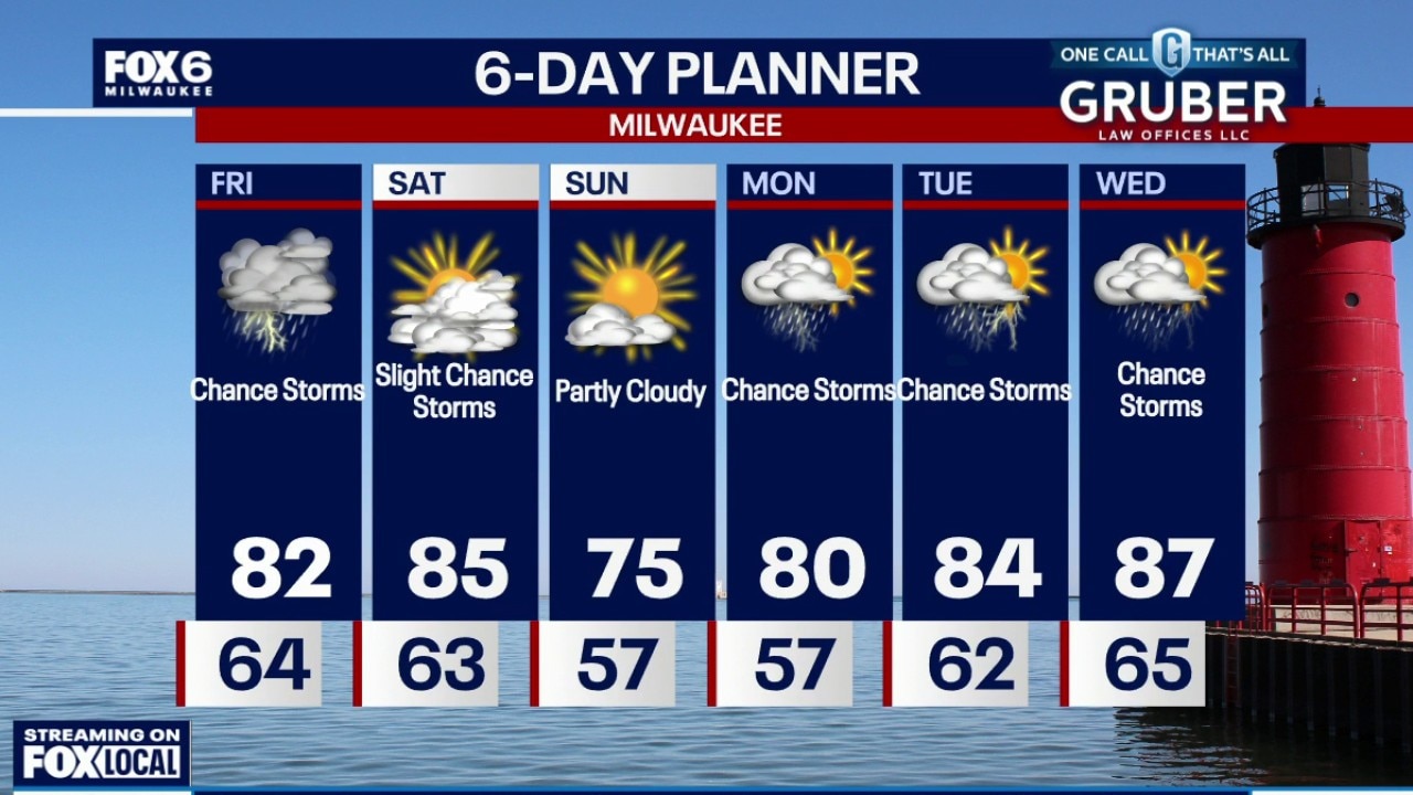
We are tracking a chance for storms tonight through Saturday.
We are tracking a chance for storms tonight through Saturday.