


Weather webcast with Rob Haswell
High pressure continues to dominate our region keeping things calm for a few more days.
High pressure continues to dominate our region keeping things calm for a few more days.

Weather Webcast with Chief Meteorologist Tom Wachs
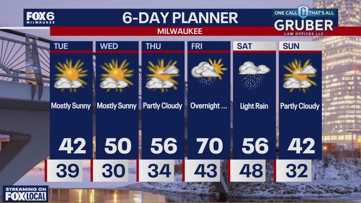
Partly sunny on Wednesday with a high around 50 inland, low 40s near the lake. 50s area-wide on Thursday and 60s on Friday.
Partly sunny on Wednesday with a high around 50 inland, low 40s near the lake. 50s area-wide on Thursday and 60s on Friday.

Weather Webcast with Chief Meteorologist Tom Wachs
Mostly clear this evening with temperatures in the 30s. Partly sunny on Wednesday with a high around 50 inland, low 40s along the lakeshore.
Mostly clear this evening with temperatures in the 30s. Partly sunny on Wednesday with a high around 50 inland, low 40s along the lakeshore.
Weather webcast with Rob Haswell
A cooler northern high settles in over the Great Lakes Tuesday and Wednesday to keep things calm and dry.
A cooler northern high settles in over the Great Lakes Tuesday and Wednesday to keep things calm and dry.
Weather Webcast with Chief Meteorologist Tom Wachs
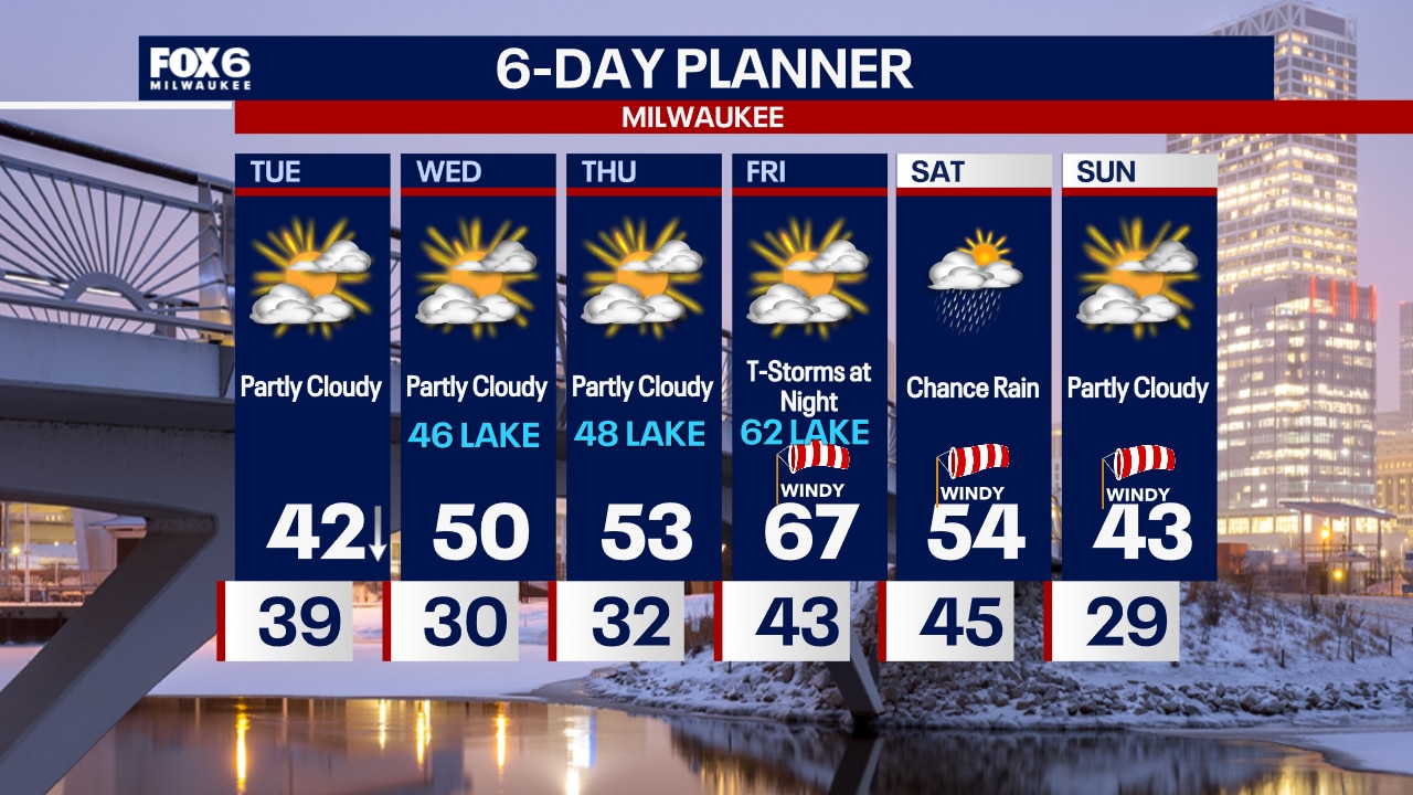
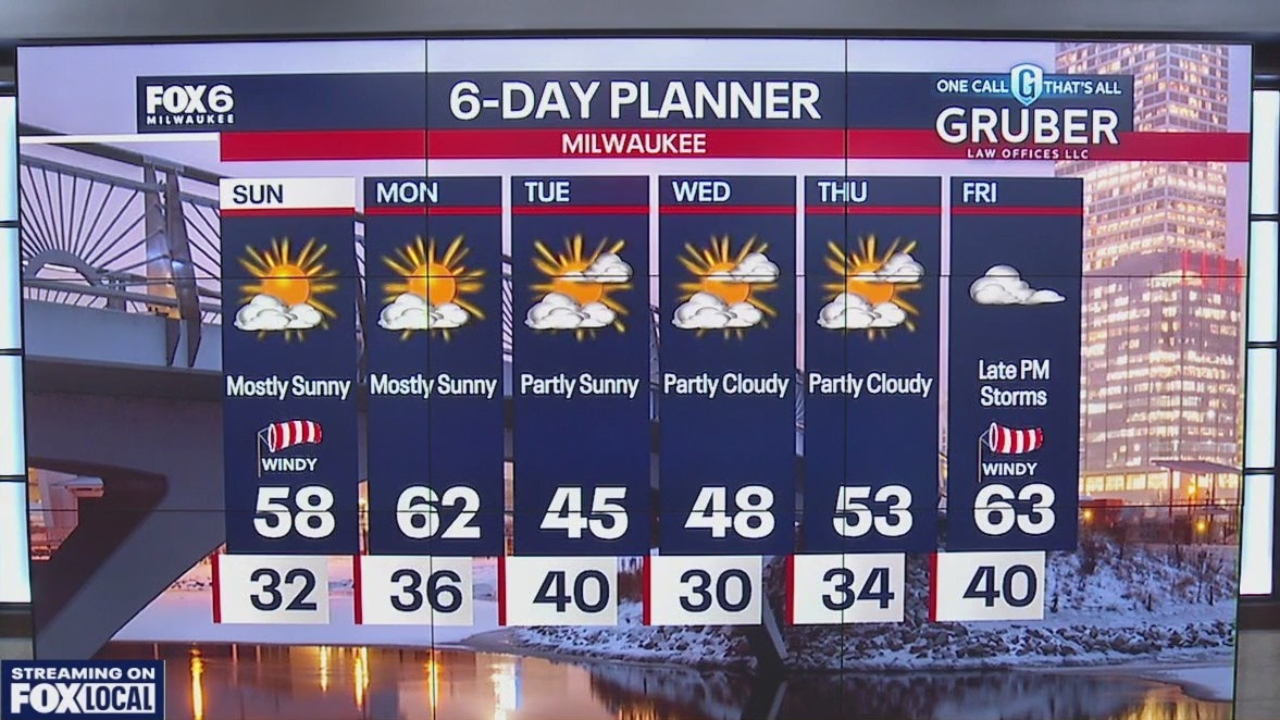
A big drop is temperature is on the way Tuesday behind a cold front. Temperatures will drop into the 30s near the lake by noon under partly cloudy skies. It will be blustery, which means the wind chills will be in the 20s.
A big drop is temperature is on the way Tuesday behind a cold front. Temperatures will drop into the 30s near the lake by noon under partly cloudy skies. It will be blustery, which means the wind chills will be in the 20s.
Weather Webcast with Chief Meteorologist Tom Wachs
Mostly clear tonight with temperatures dropping through the 50s and settling in the 30s/low 40s overnight. Partly sunny and MUCH cooler on Tuesday. Afternoon temperatures in the 30s near the lake.
Mostly clear tonight with temperatures dropping through the 50s and settling in the 30s/low 40s overnight. Partly sunny and MUCH cooler on Tuesday. Afternoon temperatures in the 30s near the lake.
Weather webcast with Rob Haswell
A strong low well to our north and a strong area of high pressure to our south sets up the perfect warming trend for Monday with highs reaching the upper 60s!
A strong low well to our north and a strong area of high pressure to our south sets up the perfect warming trend for Monday with highs reaching the upper 60s!

Weather Webcast with Chief Meteorologist Tom Wachs
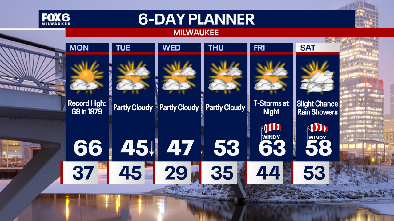
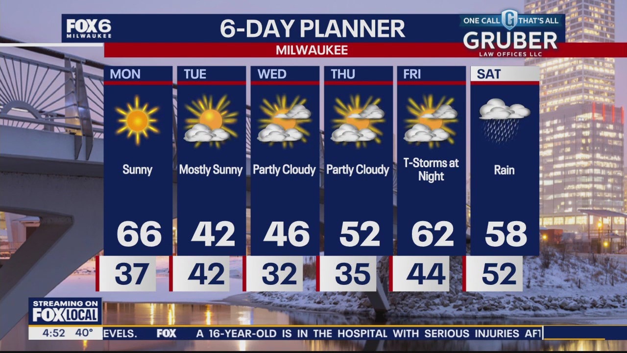
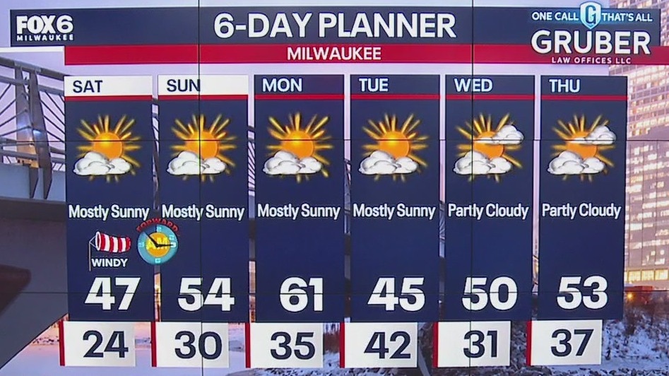
Mostly clear tonight with temperatures dropping into the 30s. Mostly sunny with a near-record high on Monday. Highs in the mid-to-upper 60s with gusty SW winds. Fire danger is elevated. Our record high is 68 from 1879.
Mostly clear tonight with temperatures dropping into the 30s. Mostly sunny with a near-record high on Monday. Highs in the mid-to-upper 60s with gusty SW winds. Fire danger is elevated. Our record high is 68 from 1879.

Weather Webcast with Chief Meteorologist Tom Wachs
Mostly clear tonight with temperatures dropping into the 40s and settling in the 30s overnight. Mostly sunny on Monday with a near-record high of 66. The current record is 68 from 1879.
Mostly clear tonight with temperatures dropping into the 40s and settling in the 30s overnight. Mostly sunny on Monday with a near-record high of 66. The current record is 68 from 1879.
Weather webcast with Lisa Michaels
Mostly sunny skies Sunday with even warmer temperatures reaching the upper 50s. Breezy at times with gusts up to 25mph.
Mostly sunny skies Sunday with even warmer temperatures reaching the upper 50s. Breezy at times with gusts up to 25mph.

Weather Webcast with Holly Baker
The warming trend continues through Monday.
The warming trend continues through Monday.
Weather webcast with Lisa Michaels
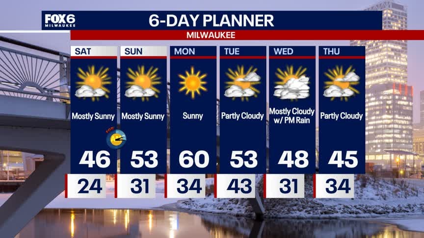
Mostly sunny Saturday with high temperatures warming into the upper 40s. Breezy with wind gusts 20 - 30mph. Mostly clear skies Saturday night with temperatures dropping into the upper 20s and low 30s.
Mostly sunny Saturday with high temperatures warming into the upper 40s. Breezy with wind gusts 20 - 30mph. Mostly clear skies Saturday night with temperatures dropping into the upper 20s and low 30s.
Weather Webcast with Holly Baker
Warm and dry conditions are expected for the weekend.
Warm and dry conditions are expected for the weekend.
Weather webcast with Rob Haswell
A small area of low pressure will just graze parts of our area with some light snow Friday. Areas along and south of I-94 could see a few tenths of an inch to a full inch of accumulation while areas north will see nothing.
A small area of low pressure will just graze parts of our area with some light snow Friday. Areas along and south of I-94 could see a few tenths of an inch to a full inch of accumulation while areas north will see nothing.
Weather Webcast with Chief Meteorologist Tom Wachs
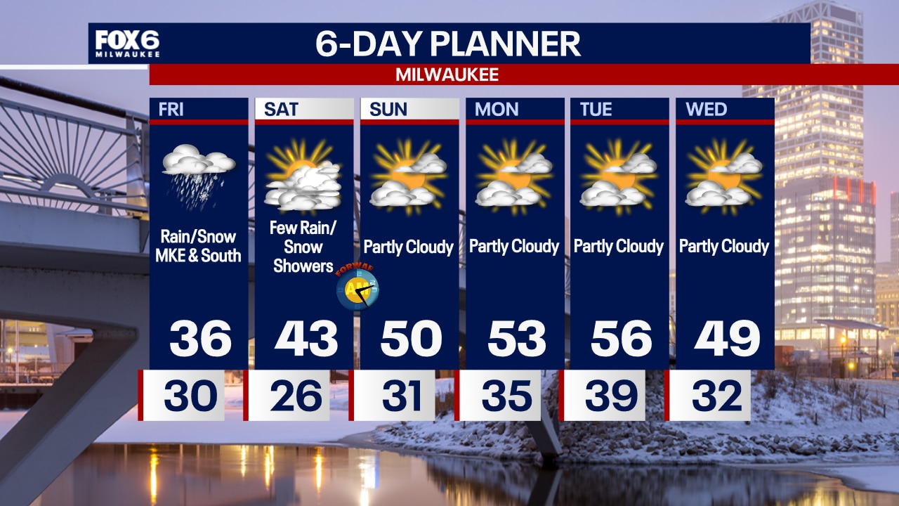
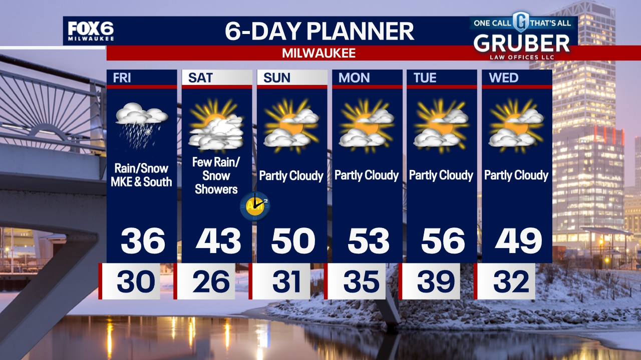
Rain and snow showers will move in from the southwest after 9am to 10am and mainly impact areas along and south of I-94. Slushy accumulation is possible in spots. Rain/snow will end by 7-8pm. Highs in the mid-30s.
Rain and snow showers will move in from the southwest after 9am to 10am and mainly impact areas along and south of I-94. Slushy accumulation is possible in spots. Rain/snow will end by 7-8pm. Highs in the mid-30s.
Weather Webcast with Chief Meteorologist Tom Wachs
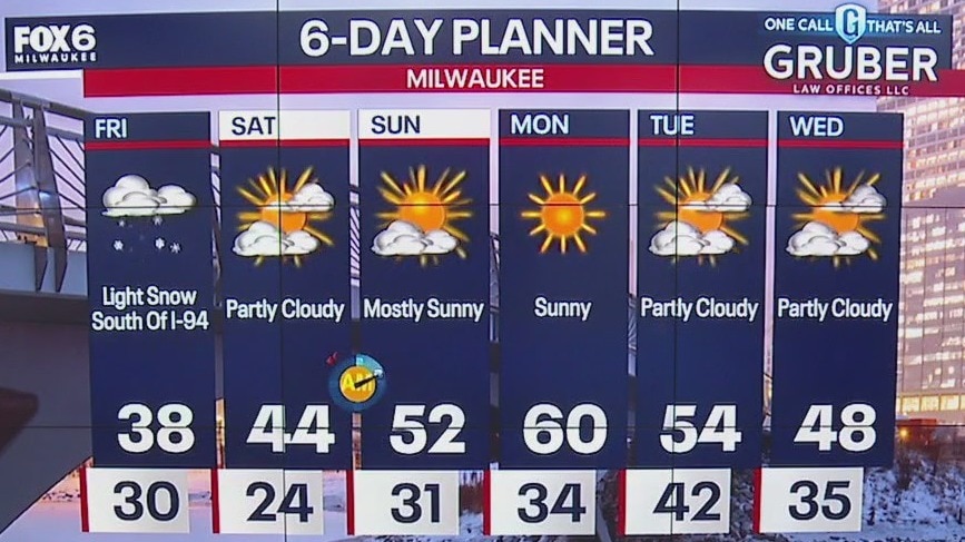
Increasing clouds tonight with temperatures in the 30s. Snow moves in after 9am from Milwaukee and south on Friday. 0.5" to 1.0" of accumulation is possible during the day Friday.
Increasing clouds tonight with temperatures in the 30s. Snow moves in after 9am from Milwaukee and south on Friday. 0.5" to 1.0" of accumulation is possible during the day Friday.

Weather webcast with Rob Haswell
High pressure moves over our region today giving us ample sun on this Thursday after a cloudy wet day Wednesday. Temperatures will be cooler with highs reaching the upper 30s to near 40.
High pressure moves over our region today giving us ample sun on this Thursday after a cloudy wet day Wednesday. Temperatures will be cooler with highs reaching the upper 30s to near 40.

Weather Webcast with Chief Meteorologist Tom Wachs
Snow is ending but the wind continues. A Wind Advisory is in effect until midnight. Becoming partly sunny on Thursday, still windy with highs in the upper 30s.
Snow is ending but the wind continues. A Wind Advisory is in effect until midnight. Becoming partly sunny on Thursday, still windy with highs in the upper 30s.

Weather webcast with Rob Haswell
A very wet morning with rain persisting into the afternoon before changing to snow later today and tonight.
A very wet morning with rain persisting into the afternoon before changing to snow later today and tonight.
Weather Webcast with Chief Meteorologist Tom Wachs
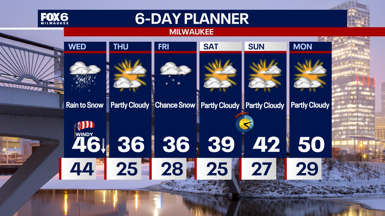
Rainy and blustery overnight with temperatures in the 40s. AM rain changing to snow in the afternoon on Wednesday. Becoming very windy. Over 1" of rain in total and 0.5"-1.0" of snow Wednesday afternoon/evening.
Rainy and blustery overnight with temperatures in the 40s. AM rain changing to snow in the afternoon on Wednesday. Becoming very windy. Over 1" of rain in total and 0.5"-1.0" of snow Wednesday afternoon/evening.