


Weather webcast with Rob Haswell
A strong warm front moves over the region for Friday helping to push daily high temperatures into the low to mid 70s in most areas.
A strong warm front moves over the region for Friday helping to push daily high temperatures into the low to mid 70s in most areas.

Webcast Weather with Holly Baker
Warmer temperatures arrive in the forecast tomorrow with a chance for morning showers.
Warmer temperatures arrive in the forecast tomorrow with a chance for morning showers.
Weather webcast with Rob Haswell
Mostly cloudy for our Thursday with a few isolated showers possible during the day.
Mostly cloudy for our Thursday with a few isolated showers possible during the day.

Weather webcast with Lisa Michaels
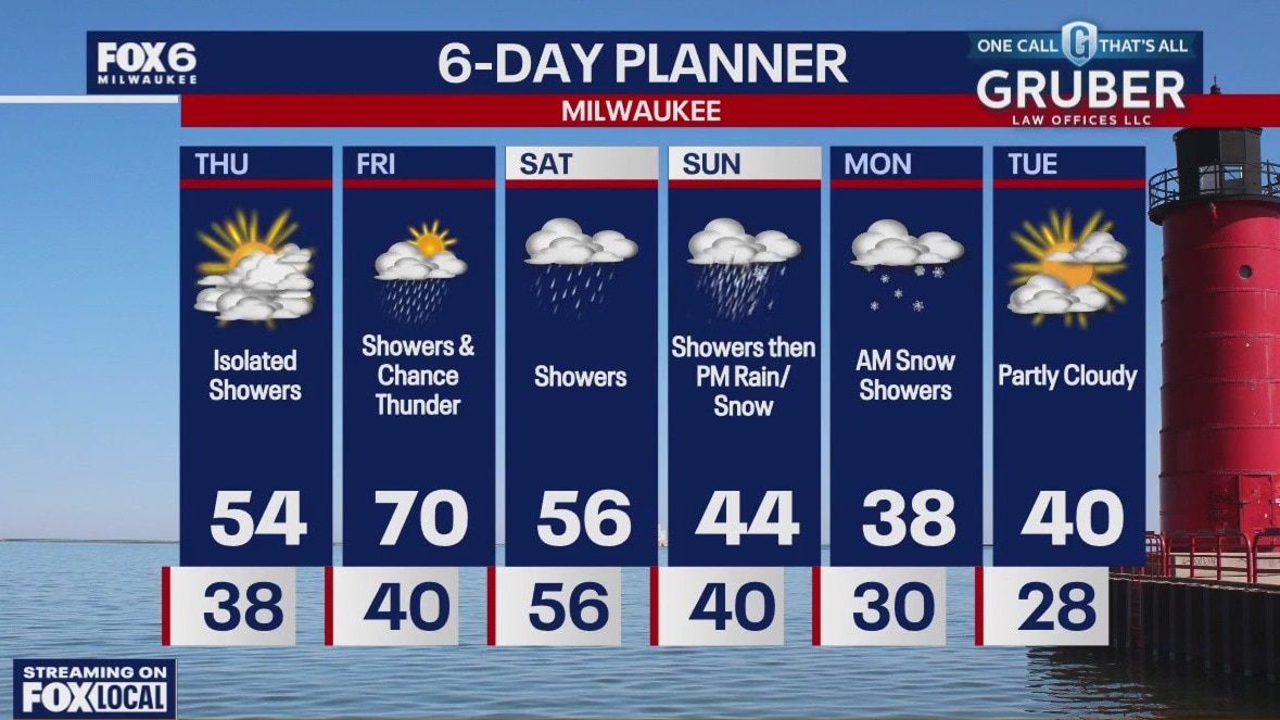
There is a chance for morning rain on Thursday then drying out in the afternoon with highs in the mid 50s. Another chance for morning rain and storms on Friday as a front stalls over southeast Wisconsin. Wind, warm, and chance of showers on Friday with highs near 70F.
There is a chance for morning rain on Thursday then drying out in the afternoon with highs in the mid 50s. Another chance for morning rain and storms on Friday as a front stalls over southeast Wisconsin. Wind, warm, and chance of showers on Friday with highs near 70F.

Weather webcast with Rob Haswell
A mostly calm day for Wednesday with at least partly sunny conditions and highs near seasonal averages.
A mostly calm day for Wednesday with at least partly sunny conditions and highs near seasonal averages.

Weather Webcast with Holly Baker
Temperatures trend warmer for the second half of the week.
Temperatures trend warmer for the second half of the week.

Weather webcast with Lisa Michaels
Clear, cool, and calm morning with a frosty start across southeast Wisconsin. Temps in the upper 20 to low 30s.
Clear, cool, and calm morning with a frosty start across southeast Wisconsin. Temps in the upper 20 to low 30s.

Weather Webcast with Holly Baker
Conditions remain dry for the next few days.
Conditions remain dry for the next few days.

Weather webcast with Lisa Michaels
Cloud stick around early Monday morning with a chance of a few lingering light snow showers and flurries.
Cloud stick around early Monday morning with a chance of a few lingering light snow showers and flurries.

Weather Webcast with Holly Baker
Drier conditions are expected for Monday.
Drier conditions are expected for Monday.

Weather webcast with Lisa Michaels
Dry Sunday morning with increasing rain chances late morning. Most areas will see steady rain. Mix of rain/snow north of I-94 near Fond du Lac and Sheboygan.
Dry Sunday morning with increasing rain chances late morning. Most areas will see steady rain. Mix of rain/snow north of I-94 near Fond du Lac and Sheboygan.

Webcast Weather with Holly Baker
More rain arrives Sunday.
More rain arrives Sunday.
Weather webcast with Lisa Michaels
Clouds linger near the lake early with chance flurries. Decreasing clouds later Sunday with highs in the mid/upper 30s. Rain arrives Sunday with a rain/snow mix north of Milwaukee towards Sheboygan.
Clouds linger near the lake early with chance flurries. Decreasing clouds later Sunday with highs in the mid/upper 30s. Rain arrives Sunday with a rain/snow mix north of Milwaukee towards Sheboygan.

Weather Webcast with Holly Baker
A cold front will bring cooler temperatures for Saturday.
A cold front will bring cooler temperatures for Saturday.

Weather webcast with Rob Haswell
A warm front lifts across southern Wisconsin for Friday, warming our area into the low to mid 50s on a strong SW wind.
A warm front lifts across southern Wisconsin for Friday, warming our area into the low to mid 50s on a strong SW wind.

Weather Webcast with Holly Baker
A warm up in temperatures will arrive tomorrow.
A warm up in temperatures will arrive tomorrow.

Weather webcast with Rob Haswell
Morning light snow for Thursday with blowing snow an issue at times. The wind will calm and the sky will clear and by the afternoon it will be a sunny upper 30s day.
Morning light snow for Thursday with blowing snow an issue at times. The wind will calm and the sky will clear and by the afternoon it will be a sunny upper 30s day.

Weather Webcast with Chief Meteorologist Tom Wachs
Very windy with snow overnight, icy roads as well. Temperatures dropping below freezing. The wind will gust over 40mph out of the NNW. AM clouds, PM sun on Thursday. Windy with highs in the upper 30s.
Very windy with snow overnight, icy roads as well. Temperatures dropping below freezing. The wind will gust over 40mph out of the NNW. AM clouds, PM sun on Thursday. Windy with highs in the upper 30s.

Weather Webcast with Chief Meteorologist Tom Wachs
T-Storms will change to snow this evening and overnight. Very windy. Snow ends by 6-7am. 1" or less Milwaukee, higher northwest. Slick conditions possible overnight.
T-Storms will change to snow this evening and overnight. Very windy. Snow ends by 6-7am. 1" or less Milwaukee, higher northwest. Slick conditions possible overnight.

Weather webcast with Rob Haswell
Rain showers arrive Wednesday morning with thunderstorms expected in the afternoon and evening.
Rain showers arrive Wednesday morning with thunderstorms expected in the afternoon and evening.