

Weather Webcast with Chief Meteorologist Tom Wachs
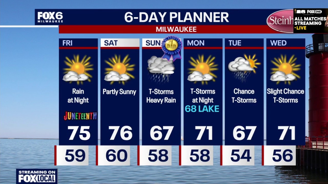
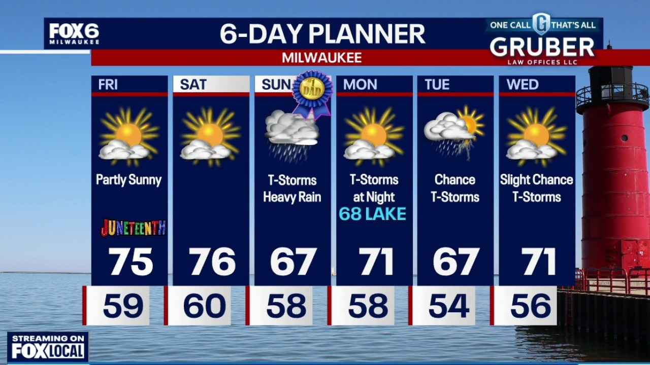
An isolated shower/t-storm ending overnight with temperatures in the 60s. Partly sunny on Friday with highs in the low 70s. Showers and a rumble of thunder possible on Friday night with temperatures in the 60s.
An isolated shower/t-storm ending overnight with temperatures in the 60s. Partly sunny on Friday with highs in the low 70s. Showers and a rumble of thunder possible on Friday night with temperatures in the 60s.
Weather Webcast with Tom Wachs
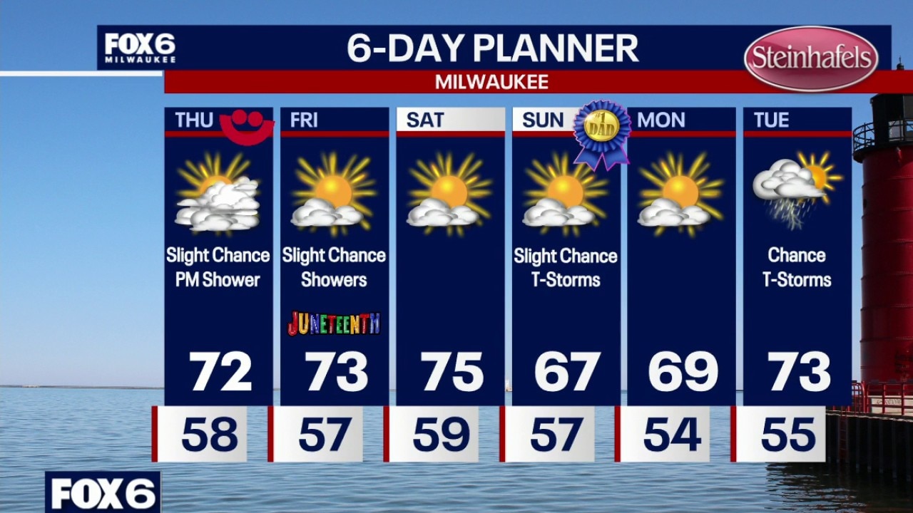
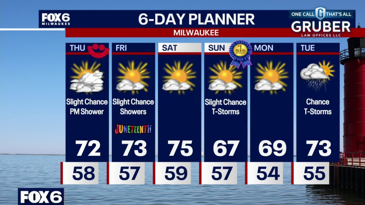
A slight chance for showers tonight and again on Friday night.
A slight chance for showers tonight and again on Friday night.
Weather webcast with Holly Baker
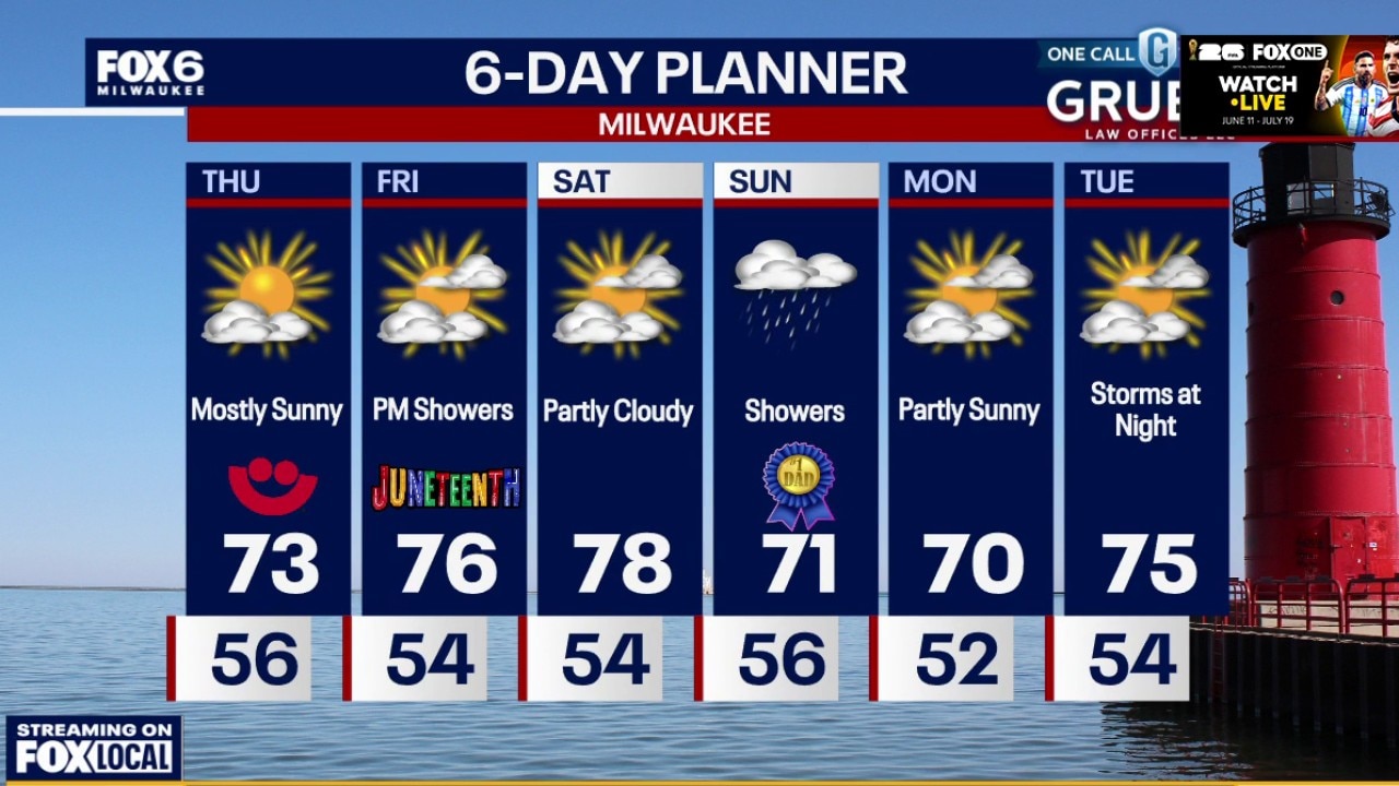
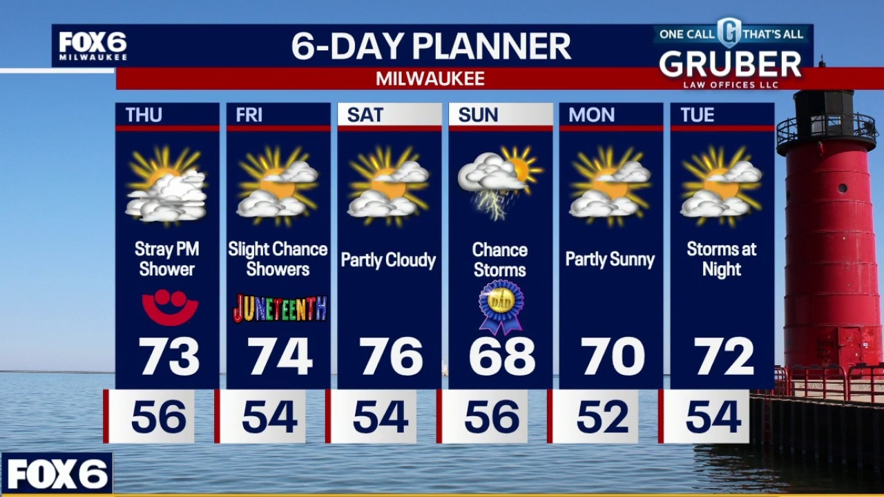
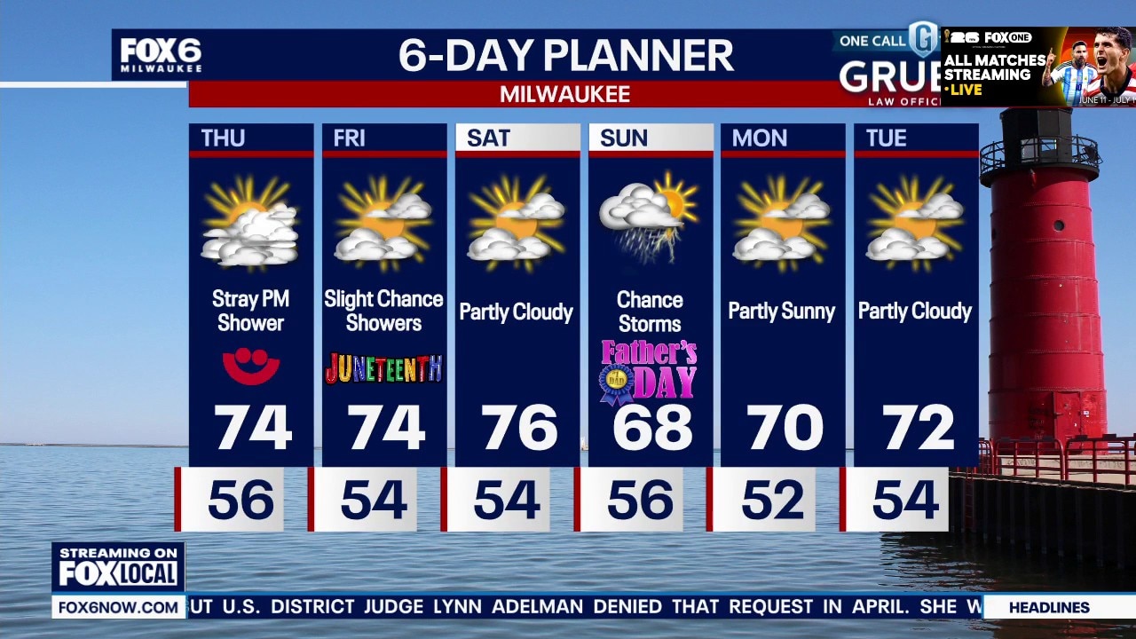
Aafternoon sunshine with temperatures reaching into the low 70s. There is a slight chance for a late day or evening rain shower. Partly sunny on Friday with a slight chance for a rain shower. Highs in the low-to-mid 70s.
Aafternoon sunshine with temperatures reaching into the low 70s. There is a slight chance for a late day or evening rain shower. Partly sunny on Friday with a slight chance for a rain shower. Highs in the low-to-mid 70s.
Weather webcast with Stephanie Barichello
Clouds to start today, then afternoon sunshine with temperatures reaching into the low 70s. There is a slight chance for a late day or evening rain shower. Partly sunny on Friday with a slight chance for a rain shower. Highs in the low-to-mid 70s.
Clouds to start today, then afternoon sunshine with temperatures reaching into the low 70s. There is a slight chance for a late day or evening rain shower. Partly sunny on Friday with a slight chance for a rain shower. Highs in the low-to-mid 70s.
Weather Webcast with Chief Meteorologist Tom Wachs
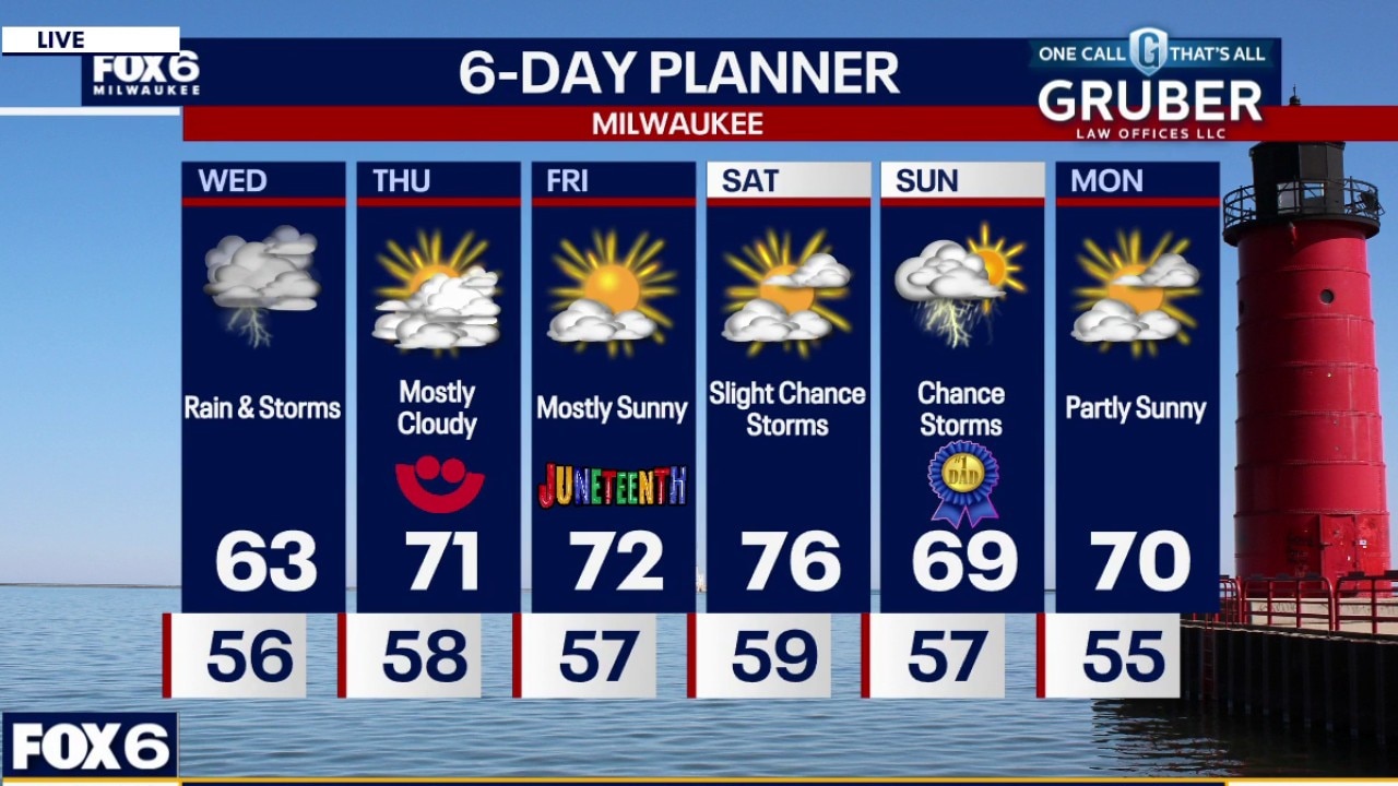
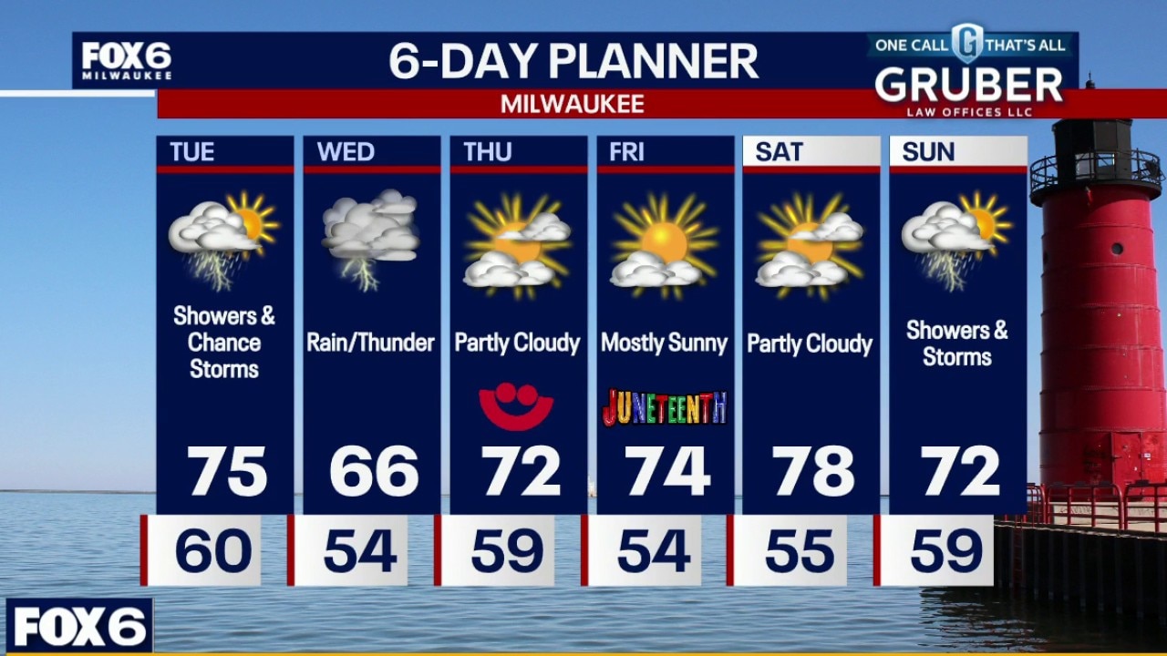
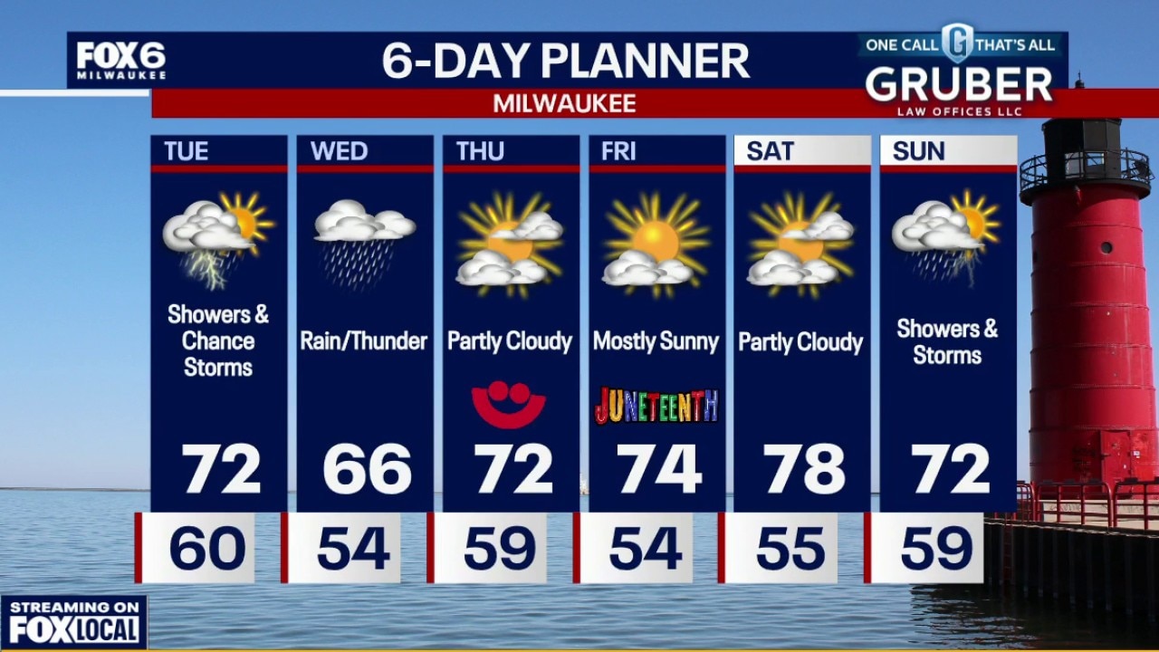
Storms have moved out. An isolated t-storm is possible otherwise partly to mostly cloudy overnight with temperatures in the 50s. Mostly cloudy and breezy on Thursday with a slight chance for a late day or evening rain shower. Highs in the low 70s. Partly sunny on Friday with a slight chance for a rain shower. Highs in the low-to-mid 70s.
Storms have moved out. An isolated t-storm is possible otherwise partly to mostly cloudy overnight with temperatures in the 50s. Mostly cloudy and breezy on Thursday with a slight chance for a late day or evening rain shower. Highs in the low 70s. Partly sunny on Friday with a slight chance for a rain shower. Highs in the low-to-mid 70s.
Weather Webcast with Chief Meteorologist Tom Wachs
Scattered t-storms this evening, gusty winds, hail and heavy rain possible. Temperatures will remain chilly, in the 50s all night. Mostly cloudy and breezy on Thursday with a slight chance for a late day or evening rain shower. Highs in the low 70s.
Scattered t-storms this evening, gusty winds, hail and heavy rain possible. Temperatures will remain chilly, in the 50s all night. Mostly cloudy and breezy on Thursday with a slight chance for a late day or evening rain shower. Highs in the low 70s.
Weather Webcast with Stephanie Barichello
Scattered showers with a few thunderstorms expected this evening, plus cool with temperatures in the 50s. A few sprinkles may linger Thursday morning, then there is a chance of a stray late evening shower. Slight chance of showers Friday, then better chance on Sunday.
Scattered showers with a few thunderstorms expected this evening, plus cool with temperatures in the 50s. A few sprinkles may linger Thursday morning, then there is a chance of a stray late evening shower. Slight chance of showers Friday, then better chance on Sunday.
Weather webcast with Stephanie Barichello
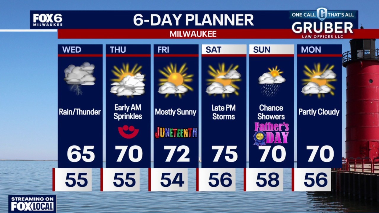
Morning rain likely with pockets of heavy rain. Highs will reach the lower 60s on Wednesday. Showers and t-storms likely on Wednesday with heavy rain. 1-2" possible Milwaukee and south, 0.50"-1.0" north of Milwaukee.
Morning rain likely with pockets of heavy rain. Highs will reach the lower 60s on Wednesday. Showers and t-storms likely on Wednesday with heavy rain. 1-2" possible Milwaukee and south, 0.50"-1.0" north of Milwaukee.
Weather webcast with Lisa Michaels
Morning rain likely with pockets of heavy rain. Highs will reach the lower 60s on Wednesday. Showers and t-storms likely on Wednesday with heavy rain. 1-2" possible Milwaukee and south, 0.50"-1.0" north of Milwaukee.
Morning rain likely with pockets of heavy rain. Highs will reach the lower 60s on Wednesday. Showers and t-storms likely on Wednesday with heavy rain. 1-2" possible Milwaukee and south, 0.50"-1.0" north of Milwaukee.
Weather Webcast with Chief Meteorologist Tom Wachs
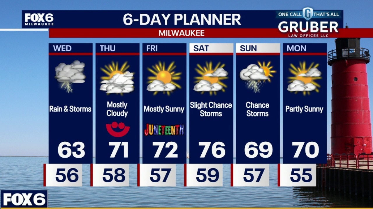
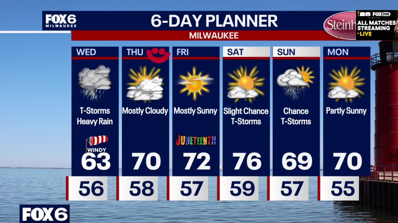
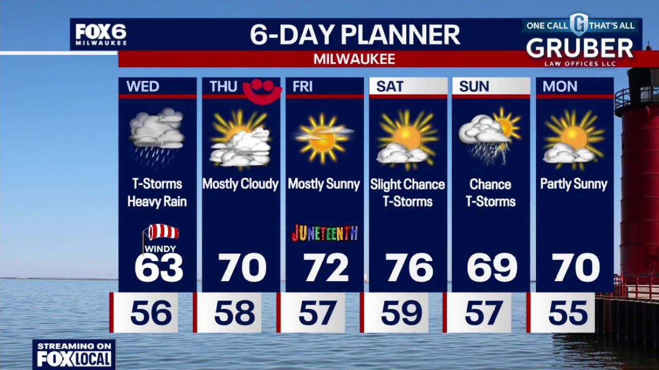
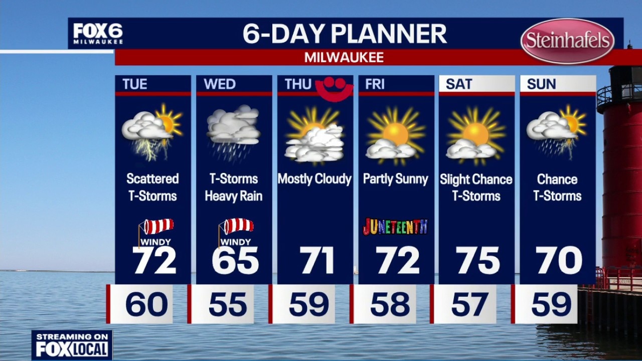
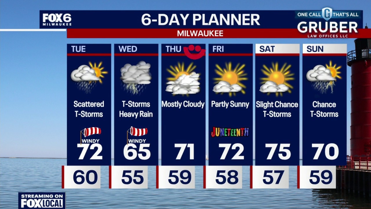
Increasing clouds overnight with temperatures dropping into the 50s. Showers and t-storms likely on Wednesday with heavy rain. 1-2" possible Milwaukee and south, 0.50"-1.0" north of Milwaukee. Cool and windy with highs in the low 60s. Severe weather risk is low, but there is a chance for wind/hail with storms mainly near the IL border. T-Storm chances continue on Wednesday night.
Increasing clouds overnight with temperatures dropping into the 50s. Showers and t-storms likely on Wednesday with heavy rain. 1-2" possible Milwaukee and south, 0.50"-1.0" north of Milwaukee. Cool and windy with highs in the low 60s. Severe weather risk is low, but there is a chance for wind/hail with storms mainly near the IL border. T-Storm chances continue on Wednesday night.
Weather Webcast with Chief Meteorologist Tom Wachs
Scattered t-storms ending this evening. Mostly cloudy with temperatures dropping through the 60s. Showers and t-storms likely on Wednesday with heavy rain. 1-2" possible Milwaukee and south, 0.50"-1.0" north of Milwaukee. Cool and windy with highs in the low 60s. Severe weather risk is low, but there is a chance for wind/hail with storms mainly near the IL border. T-Storm chances continue on Wednesday night.
Scattered t-storms ending this evening. Mostly cloudy with temperatures dropping through the 60s. Showers and t-storms likely on Wednesday with heavy rain. 1-2" possible Milwaukee and south, 0.50"-1.0" north of Milwaukee. Cool and windy with highs in the low 60s. Severe weather risk is low, but there is a chance for wind/hail with storms mainly near the IL border. T-Storm chances continue on Wednesday night.
Weather Webcast with Stephanie Barichello
A few spotty showers this evening, then multiple rounds of potentially heavy rain on Wednesday. There is a chance of strong to severe storms late in the afternoon and evening, although the main threat is south in IL. Regardless, some gusty wind and hail cannot be ruled out late in the day. Sunshine returns the rest of the week.
A few spotty showers this evening, then multiple rounds of potentially heavy rain on Wednesday. There is a chance of strong to severe storms late in the afternoon and evening, although the main threat is south in IL. Regardless, some gusty wind and hail cannot be ruled out late in the day. Sunshine returns the rest of the week.

Weather webcast with Stephanie Barichello
Southern Wisconsin is heading into an active stretch of weather with showers and thunderstorms developing Tuesday afternoon, followed by a more widespread rain event Wednesday and Wednesday night.
Southern Wisconsin is heading into an active stretch of weather with showers and thunderstorms developing Tuesday afternoon, followed by a more widespread rain event Wednesday and Wednesday night.
Weather webcast with Rob Haswell
Southern Wisconsin is heading into an active stretch of weather with showers and thunderstorms developing Tuesday afternoon, followed by a more widespread rain event Wednesday and Wednesday night.
Southern Wisconsin is heading into an active stretch of weather with showers and thunderstorms developing Tuesday afternoon, followed by a more widespread rain event Wednesday and Wednesday night.
Weather Webcast with Chief Meteorologist Tom Wachs
Increasing clouds overnight with temperatures dropping through the 60s. Scattered showers and t-storms on Tuesday starting after 5am and ending after sunset. Don't expect much rain out of this as the storms will be widely scattered throughout the day. Highs in the low 70s with a gusty west wind.
Increasing clouds overnight with temperatures dropping through the 60s. Scattered showers and t-storms on Tuesday starting after 5am and ending after sunset. Don't expect much rain out of this as the storms will be widely scattered throughout the day. Highs in the low 70s with a gusty west wind.
Weather Webcast with Chief Meteorologist Tom Wachs
Partly cloudy tonight with temperatures dropping into the 60s. Scattered showers and t-storms on Tuesday starting after 5am and ending after sunset. Don't expect much rain out of this as the storms will be widely scattered throughout the day. Highs in the low 70s with a gusty west wind.
Partly cloudy tonight with temperatures dropping into the 60s. Scattered showers and t-storms on Tuesday starting after 5am and ending after sunset. Don't expect much rain out of this as the storms will be widely scattered throughout the day. Highs in the low 70s with a gusty west wind.
Weather webcast with Lisa Michaels
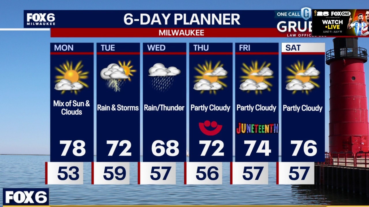
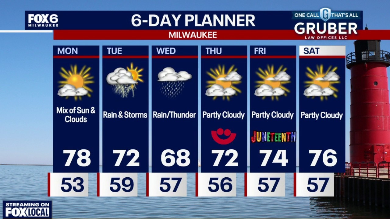
Enjoy the sunshine and comfortable temperatures Monday because the weather pattern turns much more active starting Tuesday.
Enjoy the sunshine and comfortable temperatures Monday because the weather pattern turns much more active starting Tuesday.
Weather webcast with Rob Haswell
Enjoy the sunshine and comfortable temperatures Monday because the weather pattern turns much more active starting Tuesday. Showers and thunderstorms become likely Tuesday as a strong storm system moves through Wisconsin.
Enjoy the sunshine and comfortable temperatures Monday because the weather pattern turns much more active starting Tuesday. Showers and thunderstorms become likely Tuesday as a strong storm system moves through Wisconsin.