


Weather Webcast with Meteorologist Lisa Michaels
Rain showers continue through the first half of Sunday. A transition to snow will occur this afternoon into the evening. Snow will continue through the morning commute time on Monday. Accumulation will be minimal.
Rain showers continue through the first half of Sunday. A transition to snow will occur this afternoon into the evening. Snow will continue through the morning commute time on Monday. Accumulation will be minimal.
Weather Webcast with Meteorologist Eric Manges
Get ready for a big temperature drop by Monday and even snow chances
Get ready for a big temperature drop by Monday and even snow chances

Weather Webcast with Meteorologist Lisa Michaels
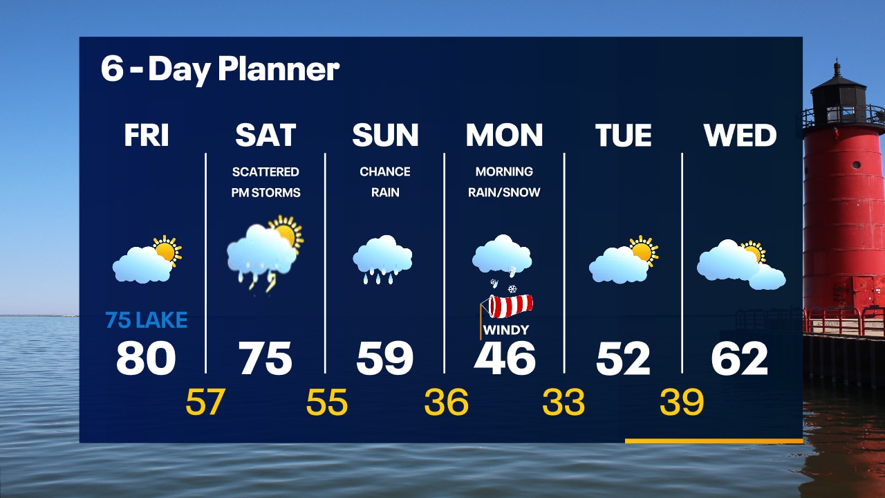
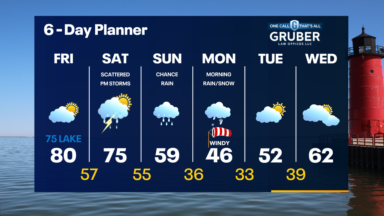
Partly cloudy to mostly cloudy today with highs reaching close to 80F. Chances of scattered rain and storms arrive this afternoon and evening. Isolated stronger storms could pose a risk for hail and damaging winds
Partly cloudy to mostly cloudy today with highs reaching close to 80F. Chances of scattered rain and storms arrive this afternoon and evening. Isolated stronger storms could pose a risk for hail and damaging winds
Weather Webcast with Meteorologist Eric Manges
Get ready for a temperature drop Sunday into Monday and even snow chances.
Get ready for a temperature drop Sunday into Monday and even snow chances.
Weather Webcast with Meteorologist Stephanie Barichello
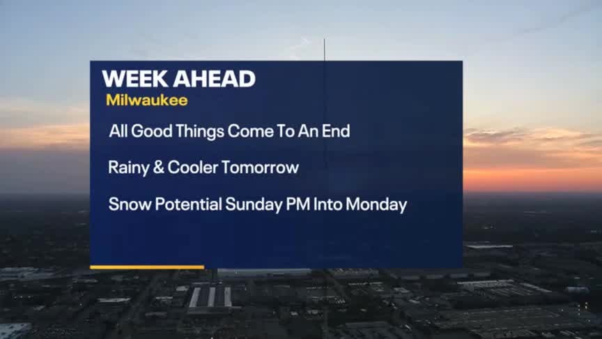
Sunny and pleasant today then a chance for storms Saturday. Rain is more likely on Sunday with slushy snow to start Monday. Warming back into the 60s by the middle of next week.
Sunny and pleasant today then a chance for storms Saturday. Rain is more likely on Sunday with slushy snow to start Monday. Warming back into the 60s by the middle of next week.
Weather webcast with Rob Haswell
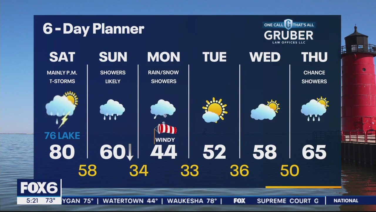
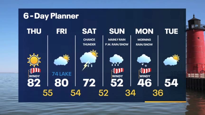
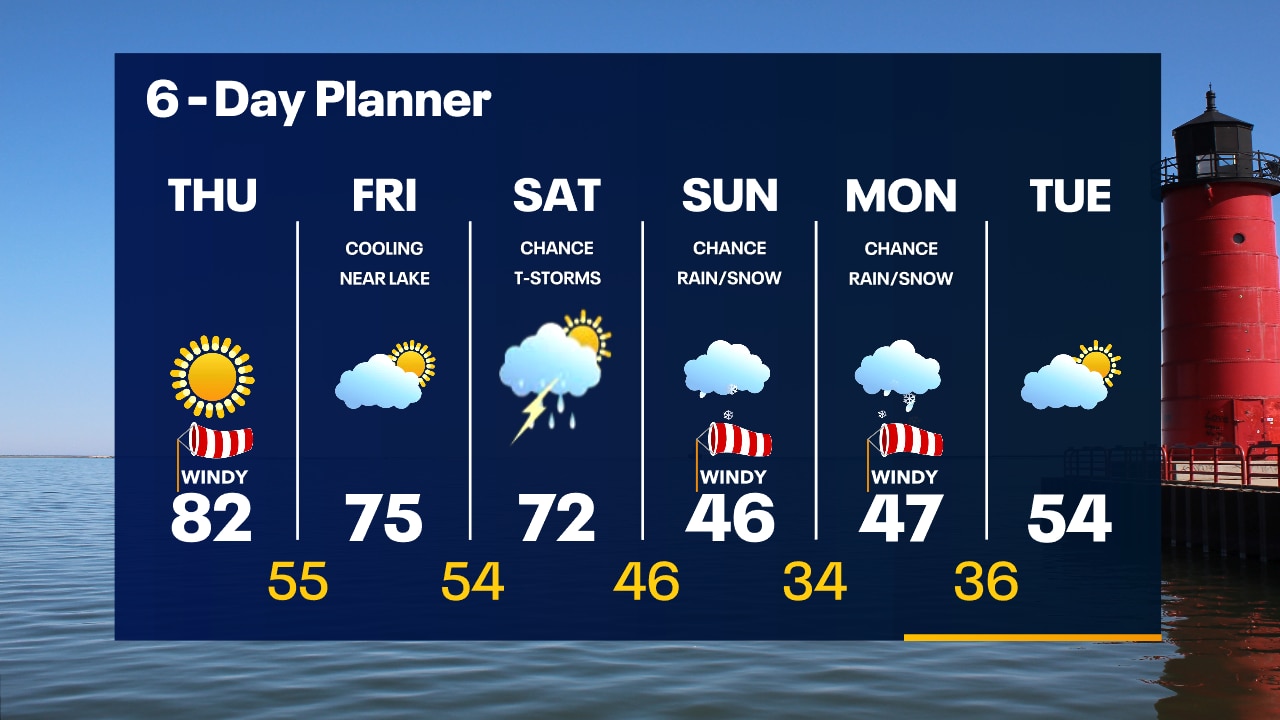
We stay ahead of an advancing cold front today and most of tomorrow keeping temperatures very warm. Highs today will be in the low 80s but with a SE wind, it will be cooler lakeside. Highs on Saturday will reach 80 inland but stay in the low 70s near the lake. By Saturday afternoon we should see some showers with a better chance of rain late Saturday into Sunday. Rain continues Sunday with a chance for thunder. Light rain and snow is possible on Monday as we cool into the 40s. We return to more seasonal weather next week.
We stay ahead of an advancing cold front today and most of tomorrow keeping temperatures very warm. Highs today will be in the low 80s but with a SE wind, it will be cooler lakeside. Highs on Saturday will reach 80 inland but stay in the low 70s near the lake. By Saturday afternoon we should see some showers with a better chance of rain late Saturday into Sunday. Rain continues Sunday with a chance for thunder. Light rain and snow is possible on Monday as we cool into the 40s. We return to more seasonal weather next week.
Weather Webcast with Tom Wachs
Mostly clear overnight with temperatures in the 50s by sunrise. More heat on the way Friday. Partly sunny with elevated fire danger. High around 80 inland, 70s near the lake.
Mostly clear overnight with temperatures in the 50s by sunrise. More heat on the way Friday. Partly sunny with elevated fire danger. High around 80 inland, 70s near the lake.
Weather Webcast with Tom Wachs
Mostly clear tonight with temperatures dropping through the 60s and into the 50s overnight. Partly sunny and warm on Friday. High around 80 inland, mid-70s near the lake.
Mostly clear tonight with temperatures dropping through the 60s and into the 50s overnight. Partly sunny and warm on Friday. High around 80 inland, mid-70s near the lake.
Weather Webcast with Meteorologist Stephanie Barichello
More sunshine and warmth today then slightly cooler lakeside on Friday. There is a chance for storms by Saturday afternoon and evening, then bigger changes Sunday and Monday. It'll be windy and cooler with some snow mixing in Monday morning.
More sunshine and warmth today then slightly cooler lakeside on Friday. There is a chance for storms by Saturday afternoon and evening, then bigger changes Sunday and Monday. It'll be windy and cooler with some snow mixing in Monday morning.
Weather webcast with Rob Haswell
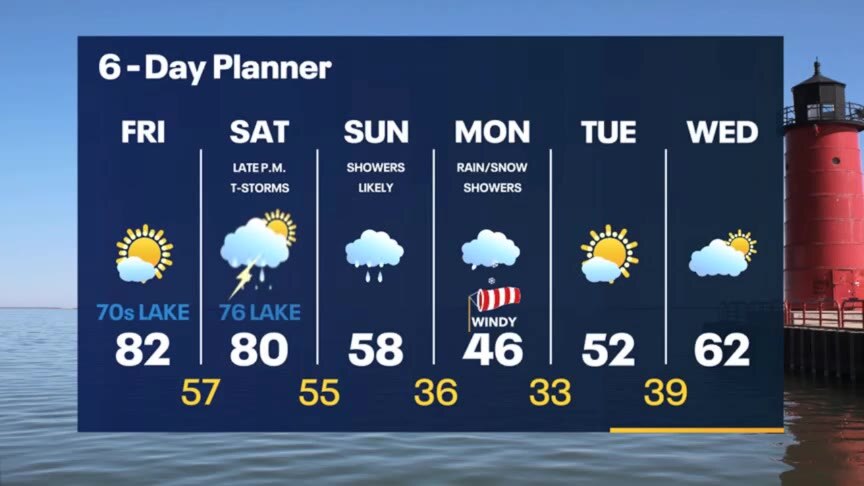
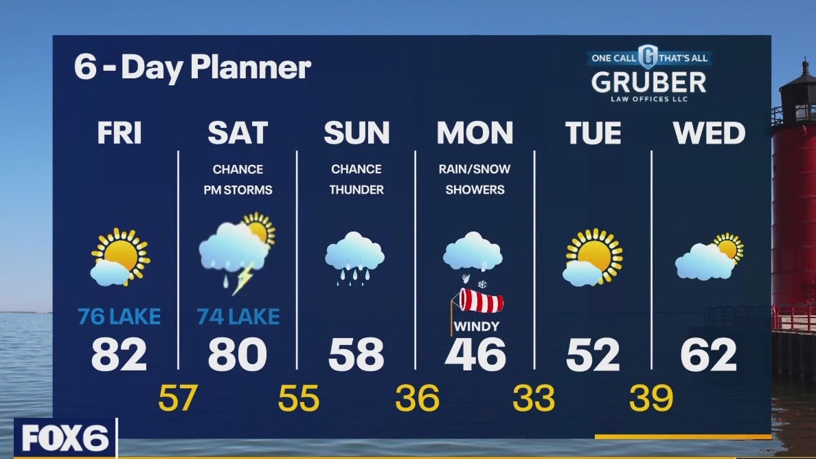
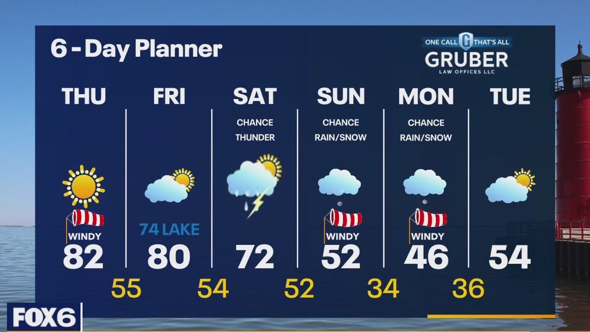
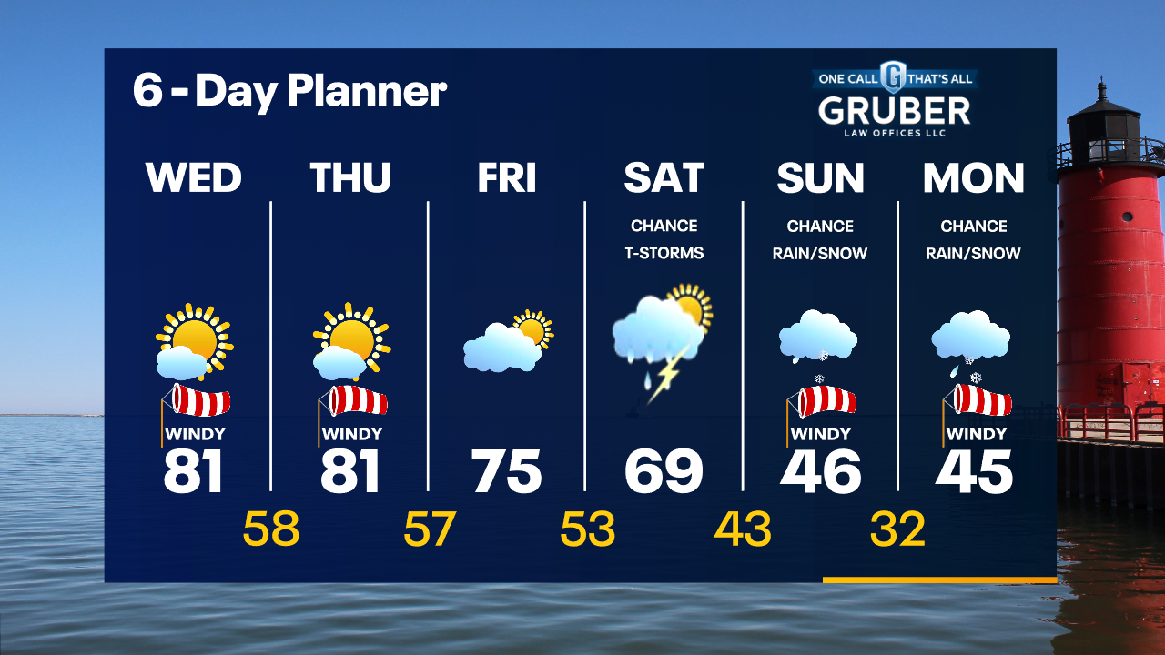
Red Flag Warning today until 8pm. Avoid any open fires or things that may spark a fire today. High pressure still dominates our area keeping us sunny and helping with a strong southwesterly wind to warm us into the low 80s again. We stay mild ahead of a low Friday but will cool down this weekend with rain likely on Saturday and a chance for thunderstorms. Much cooler Sunday and Monday with a chance for rain/snow showers.
Red Flag Warning today until 8pm. Avoid any open fires or things that may spark a fire today. High pressure still dominates our area keeping us sunny and helping with a strong southwesterly wind to warm us into the low 80s again. We stay mild ahead of a low Friday but will cool down this weekend with rain likely on Saturday and a chance for thunderstorms. Much cooler Sunday and Monday with a chance for rain/snow showers.
Weather Webcast with Tom Wachs
Clear and breezy overnight with temperatures in the upper 50s to low 60s by sunrise. Sunny, windy and warm again Thursday. Record highs in the low 80s. High fire danger.
Clear and breezy overnight with temperatures in the upper 50s to low 60s by sunrise. Sunny, windy and warm again Thursday. Record highs in the low 80s. High fire danger.

Weather Webcast with Tom Wachs
High fire danger continues with record heat. We broke a record high in Milwaukee Wednesday & will likely do it again Thursday with highs in the 80s.
High fire danger continues with record heat. We broke a record high in Milwaukee Wednesday & will likely do it again Thursday with highs in the 80s.
Weather Webcast with Meteorologist Stephanie Barichello
Sunny, windy and warm the next two days with potentially record breaking temperatures. A few more clouds Friday then rain returns Saturday. Much cooler Sunday and Monday with a chance for wintry mix.
Sunny, windy and warm the next two days with potentially record breaking temperatures. A few more clouds Friday then rain returns Saturday. Much cooler Sunday and Monday with a chance for wintry mix.
Weather webcast with Rob Haswell
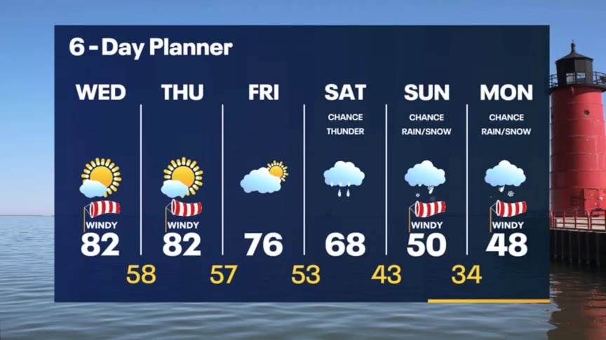
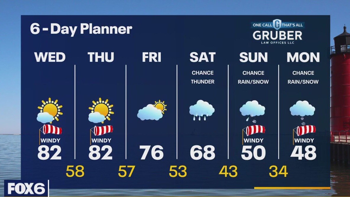
Red Flag Warning Today (Wednesday) From 11am Until 8pm. Caution is advised with any outdoor fires or when using any equipment that may cause sparks. Sunny, windy and warm today with highs in the low 80s. We will see a repeat of this for tomorrow before our pattern changes. Rain and a chance for thunderstorms on Saturday as a cold front passes through. Rain/snow showers possible Sunday and Monday with cooler air returning.
Red Flag Warning Today (Wednesday) From 11am Until 8pm. Caution is advised with any outdoor fires or when using any equipment that may cause sparks. Sunny, windy and warm today with highs in the low 80s. We will see a repeat of this for tomorrow before our pattern changes. Rain and a chance for thunderstorms on Saturday as a cold front passes through. Rain/snow showers possible Sunday and Monday with cooler air returning.

Weather Webcast with Tom Wachs
Mostly clear overnight with temperatures in the upper 50s by sunrise. Mostly sunny, windy and warm on Wednesday with a near-record high in the low 80s. High fire danger Wednesday.
Mostly clear overnight with temperatures in the upper 50s by sunrise. Mostly sunny, windy and warm on Wednesday with a near-record high in the low 80s. High fire danger Wednesday.
Weather Webcast with Tom Wachs
Mostly clear tonight with temperatures falling through the 60s. Mostly sunny, windy and warm on Wednesday with a near-record high in the low 80s.
Mostly clear tonight with temperatures falling through the 60s. Mostly sunny, windy and warm on Wednesday with a near-record high in the low 80s.

Weather Webcast With Lisa Michaels
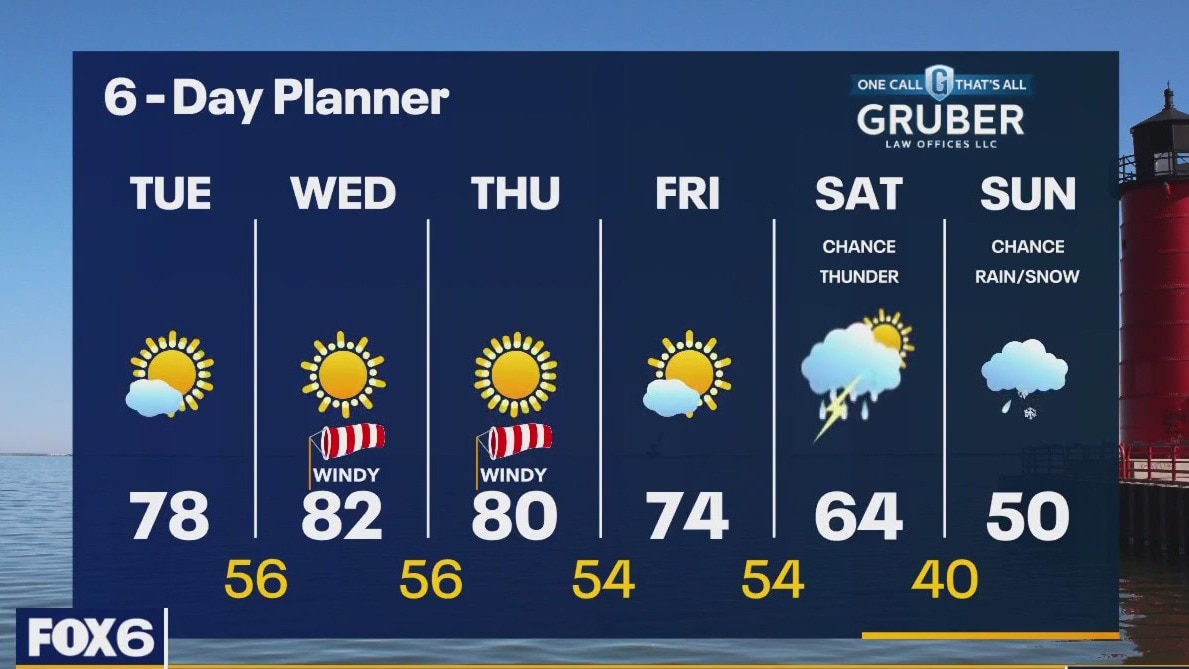
An area of high pressure to our east helps with a strong southerly flow of very warm air for the next few days. Temperatures will warm into the upper 70s and low 80s for the next three days. Potential record high temps can occur. A cold front arrives late Friday into Saturday. Ahead of that front we will see rain and a chance for thunderstorms. Behind the front, we cool down. We return to more seasonal temperatures in the low 50s next week.
An area of high pressure to our east helps with a strong southerly flow of very warm air for the next few days. Temperatures will warm into the upper 70s and low 80s for the next three days. Potential record high temps can occur. A cold front arrives late Friday into Saturday. Ahead of that front we will see rain and a chance for thunderstorms. Behind the front, we cool down. We return to more seasonal temperatures in the low 50s next week.
Weather webcast with Rob Haswell
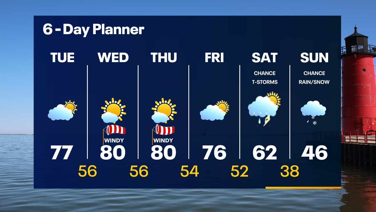
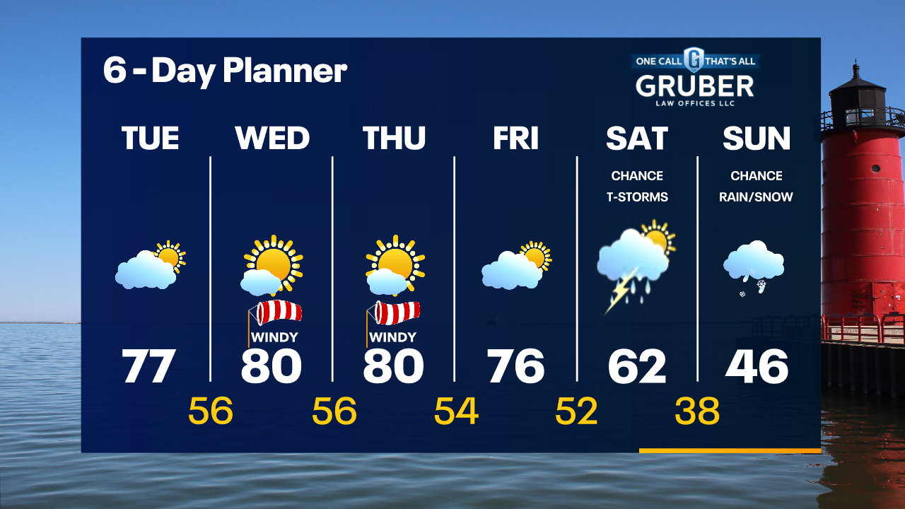
An area of high pressure to our east helps with a strong southerly flow of very warm air for the next few days. Temperatures will warm into the upper 70s and low 80s for the next three days. A cold front arrives late Friday into Saturday. Ahead of that front we will see rain and a chance for thunderstorms. Behind the front, we cool down. We return to more seasonal temperatures in the low 50s next week.
An area of high pressure to our east helps with a strong southerly flow of very warm air for the next few days. Temperatures will warm into the upper 70s and low 80s for the next three days. A cold front arrives late Friday into Saturday. Ahead of that front we will see rain and a chance for thunderstorms. Behind the front, we cool down. We return to more seasonal temperatures in the low 50s next week.
Weather Webcast with Tom Wachs
Mostly clear overnight with temperatures in the upper 40s to low 50s by sunrise. Breezy and warmer on Tuesday with highs in the mid-to-upper 70s.
Mostly clear overnight with temperatures in the upper 40s to low 50s by sunrise. Breezy and warmer on Tuesday with highs in the mid-to-upper 70s.
Weather Webcast with Tom Wachs
This warm stretch of weather continues. Highs in the 70s again on Tuesday. Temperatures approach 80 on Wednesday and Thursday with gusty southwest winds.
This warm stretch of weather continues. Highs in the 70s again on Tuesday. Temperatures approach 80 on Wednesday and Thursday with gusty southwest winds.