

Weather webcast with Lisa Michaels
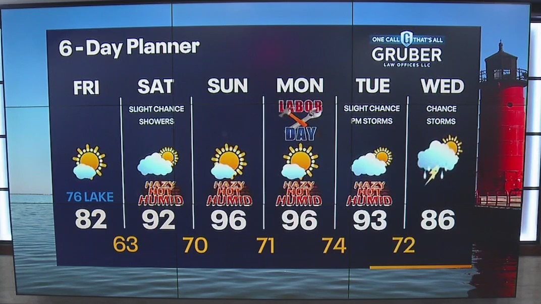
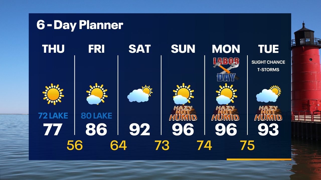
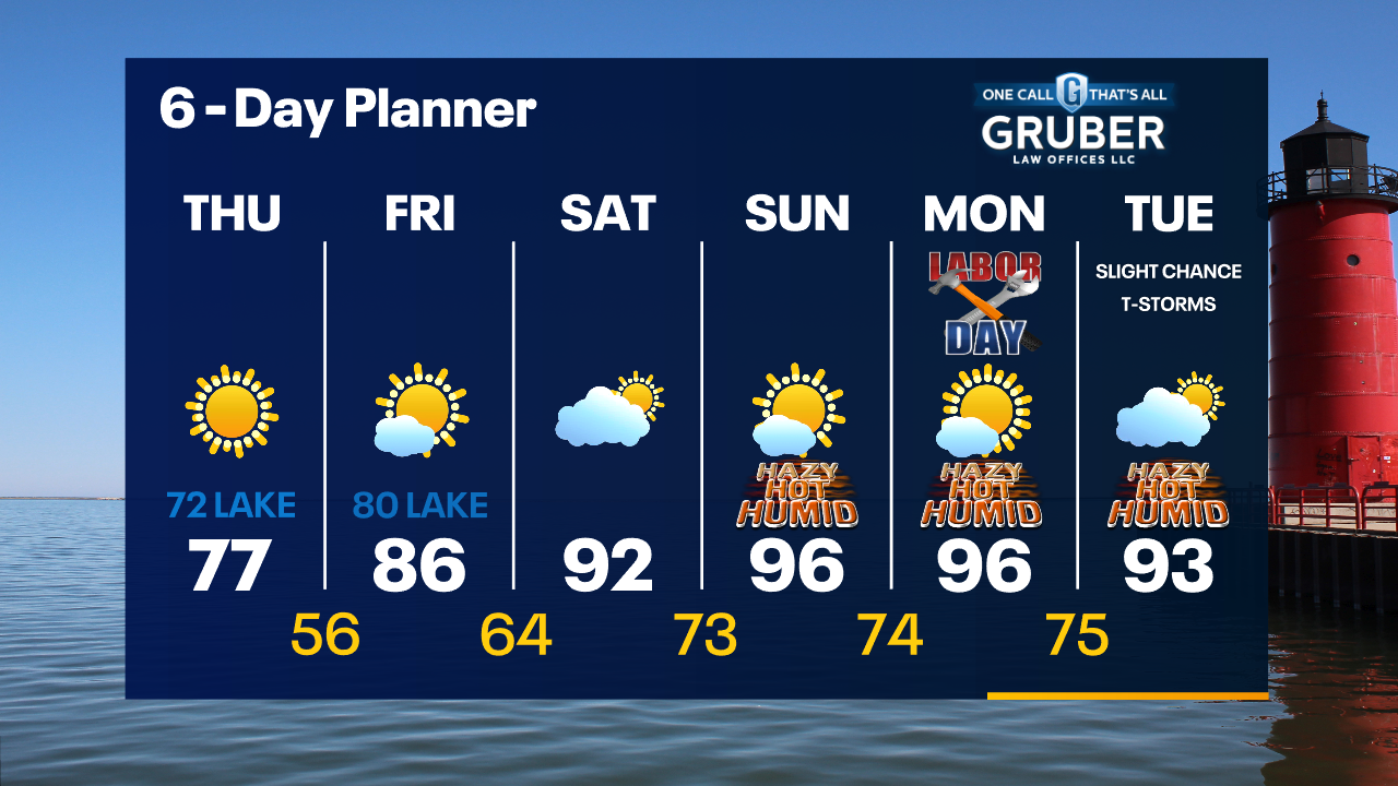
Mostly sunny, breezy and warmer on Friday. Highs in the low to mid-80s inland,mid-70s near the lake. Windy, hot and humid this weekend. Highs in the low-to-mid 90s for the holiday weekend and into Tuesday. The afternoon heat index will be upper 90s to maybe low 100F. Record highs could be broken this weekend as well. A cold front will come through Wednesday which will start to cool us down later in the week. Small chance of rain Saturday with better chances arriving next week.
Mostly sunny, breezy and warmer on Friday. Highs in the low to mid-80s inland,mid-70s near the lake. Windy, hot and humid this weekend. Highs in the low-to-mid 90s for the holiday weekend and into Tuesday. The afternoon heat index will be upper 90s to maybe low 100F. Record highs could be broken this weekend as well. A cold front will come through Wednesday which will start to cool us down later in the week. Small chance of rain Saturday with better chances arriving next week.
Weather Webcast with Tom Wachs
Clear skies overnight with temperatures in the 50s. Mostly sunny and warmer on Friday with highs in the 80s. Heat returns this weekend with highs in the 90s. A few spotty rain showers are possible Saturday.
Clear skies overnight with temperatures in the 50s. Mostly sunny and warmer on Friday with highs in the 80s. Heat returns this weekend with highs in the 90s. A few spotty rain showers are possible Saturday.
Weather Webcast with Tom Wachs
Clear skies tonight with temperatures dropping through the 60s this evening and 50s overnight. Mostly sunny on Friday with highs in the 80s. 90s return this weekend.
Clear skies tonight with temperatures dropping through the 60s this evening and 50s overnight. Mostly sunny on Friday with highs in the 80s. 90s return this weekend.
Weather Webcast with Meteorologist Eric Manges
Heat returns in no time so enjoy these sunny and cooler conditions
Heat returns in no time so enjoy these sunny and cooler conditions
Weather webcast with Lisa Michaels
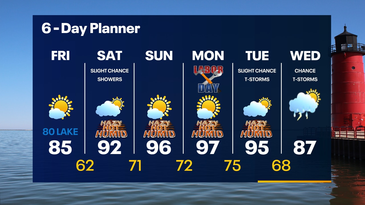
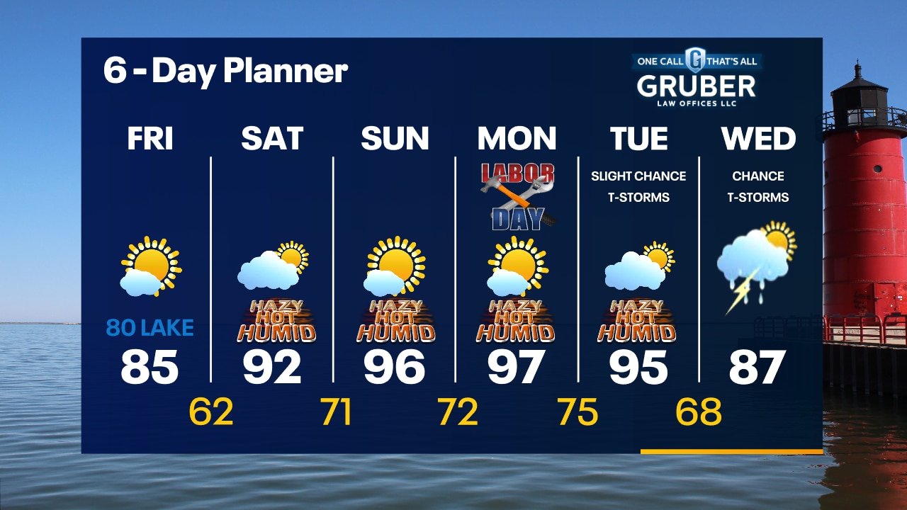
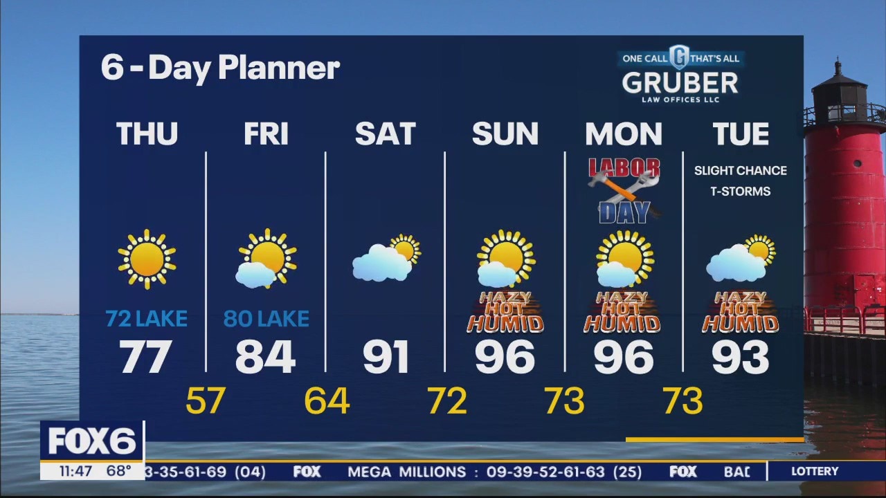
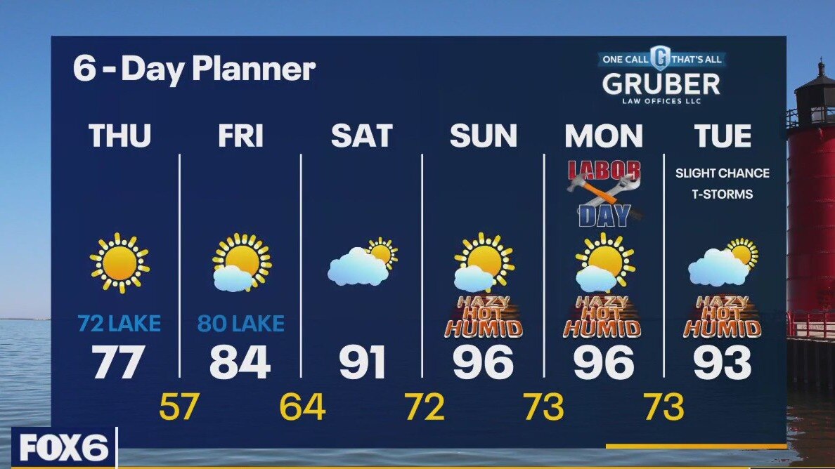
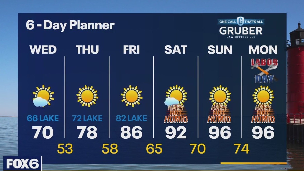
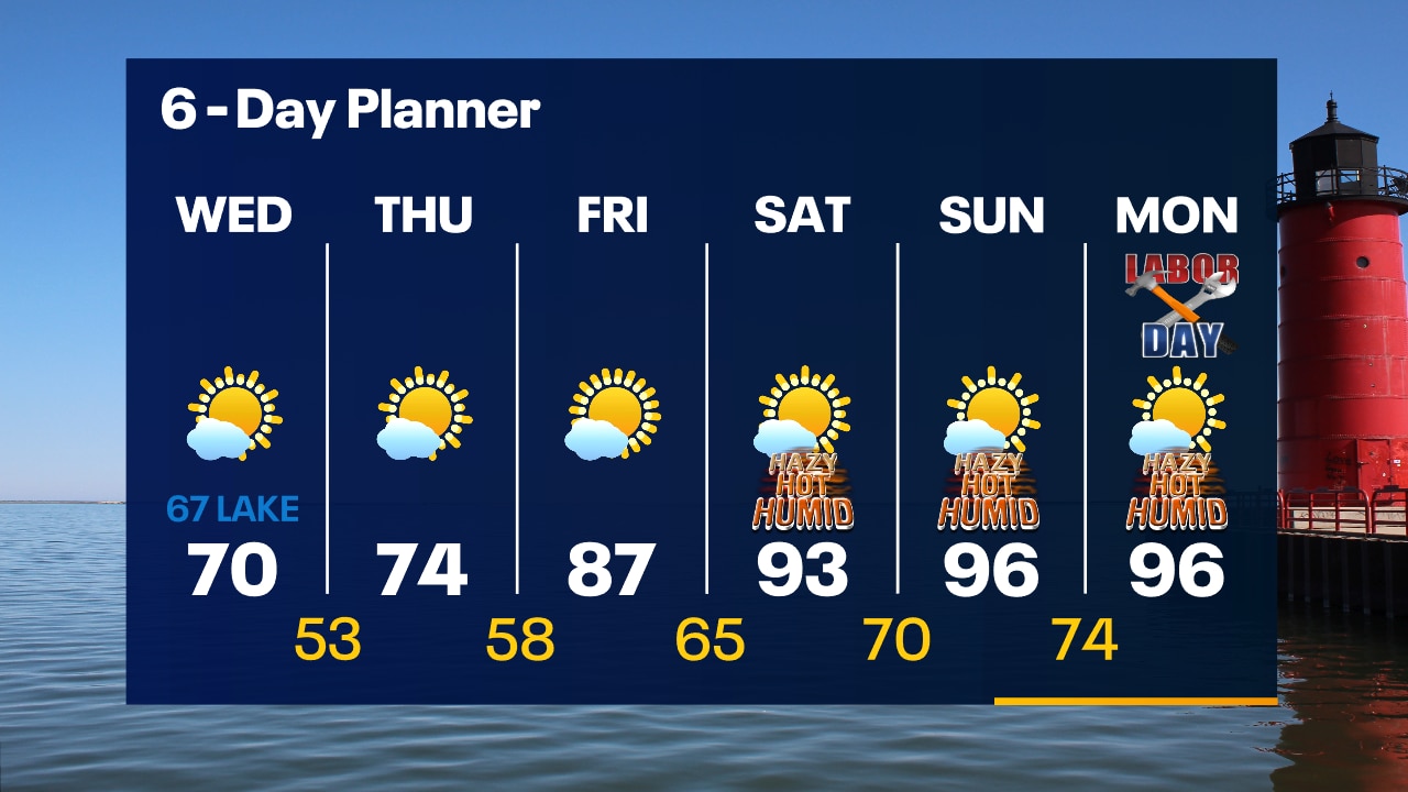
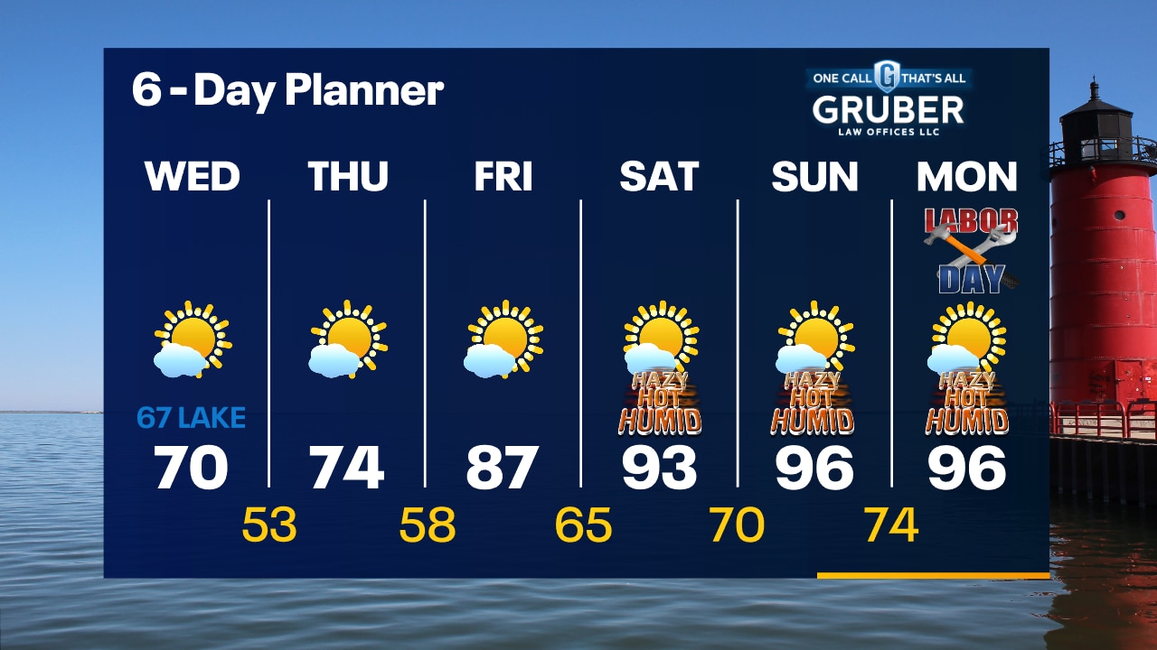
Sunny and comfortable on Thursday with highs in the 70s. Mid-to-upper 70s inland, lower 70s near the lake. Mostly sunny and warmer on Friday with highs in the 80s, coolest of the air near the lake. Breezy, hot and humid for Labor Day Weekend with highs in the low-to-mid 90s. Potential record high temps. Rather dry forecast ahead. Slight chance of a shower on Tuesday, otherwise more likely on Wednesday.
Sunny and comfortable on Thursday with highs in the 70s. Mid-to-upper 70s inland, lower 70s near the lake. Mostly sunny and warmer on Friday with highs in the 80s, coolest of the air near the lake. Breezy, hot and humid for Labor Day Weekend with highs in the low-to-mid 90s. Potential record high temps. Rather dry forecast ahead. Slight chance of a shower on Tuesday, otherwise more likely on Wednesday.
Weather Webcast with Tom Wachs
Clear skies with the Full Super Blue Moon overhead. Temperatures dropping through the 50s, even some 40s away from the lake. Sunny on Thursday with highs in the 70s.
Clear skies with the Full Super Blue Moon overhead. Temperatures dropping through the 50s, even some 40s away from the lake. Sunny on Thursday with highs in the 70s.
Weather Webcast with Tom Wachs
Clear skies with the Full Super Blue Moon rising in the southeast sky this evening. Temperatures dropping rapidly through the 50s and into the 40s away from the lake overnight.
Clear skies with the Full Super Blue Moon rising in the southeast sky this evening. Temperatures dropping rapidly through the 50s and into the 40s away from the lake overnight.
Weather webcast with Rob Haswell
An area of high pressure builds across the area today and moves slowly to the east over the next few days. We remain sunny for the next several days and after a chilly one today we start to warm up dramatically. Highs today will be in the upper 60s and low 70s but warm into the 90s by the weekend! We remain dry through early next week.
An area of high pressure builds across the area today and moves slowly to the east over the next few days. We remain sunny for the next several days and after a chilly one today we start to warm up dramatically. Highs today will be in the upper 60s and low 70s but warm into the 90s by the weekend! We remain dry through early next week.
Weather Webcast with Tom Wachs
Clear skies overnight with temperatures in the 50s by sunrise, even a few upper 40s inland. Mostly sunny and cool on Wednesday with highs struggling to get out of the 60s in most areas.
Clear skies overnight with temperatures in the 50s by sunrise, even a few upper 40s inland. Mostly sunny and cool on Wednesday with highs struggling to get out of the 60s in most areas.
Weather Webcast with Tom Wachs
Mostly clear tonight with temperatures dropping into the 50s overnight, even upper 40s possible inland. Mostly sunny and cool on Wednesday as many areas struggle to get out of the 60s.
Mostly clear tonight with temperatures dropping into the 50s overnight, even upper 40s possible inland. Mostly sunny and cool on Wednesday as many areas struggle to get out of the 60s.

Weather webcast with Rob Haswell
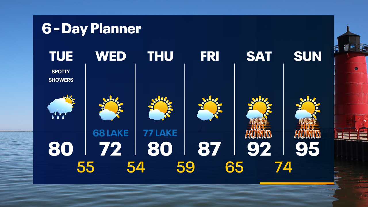
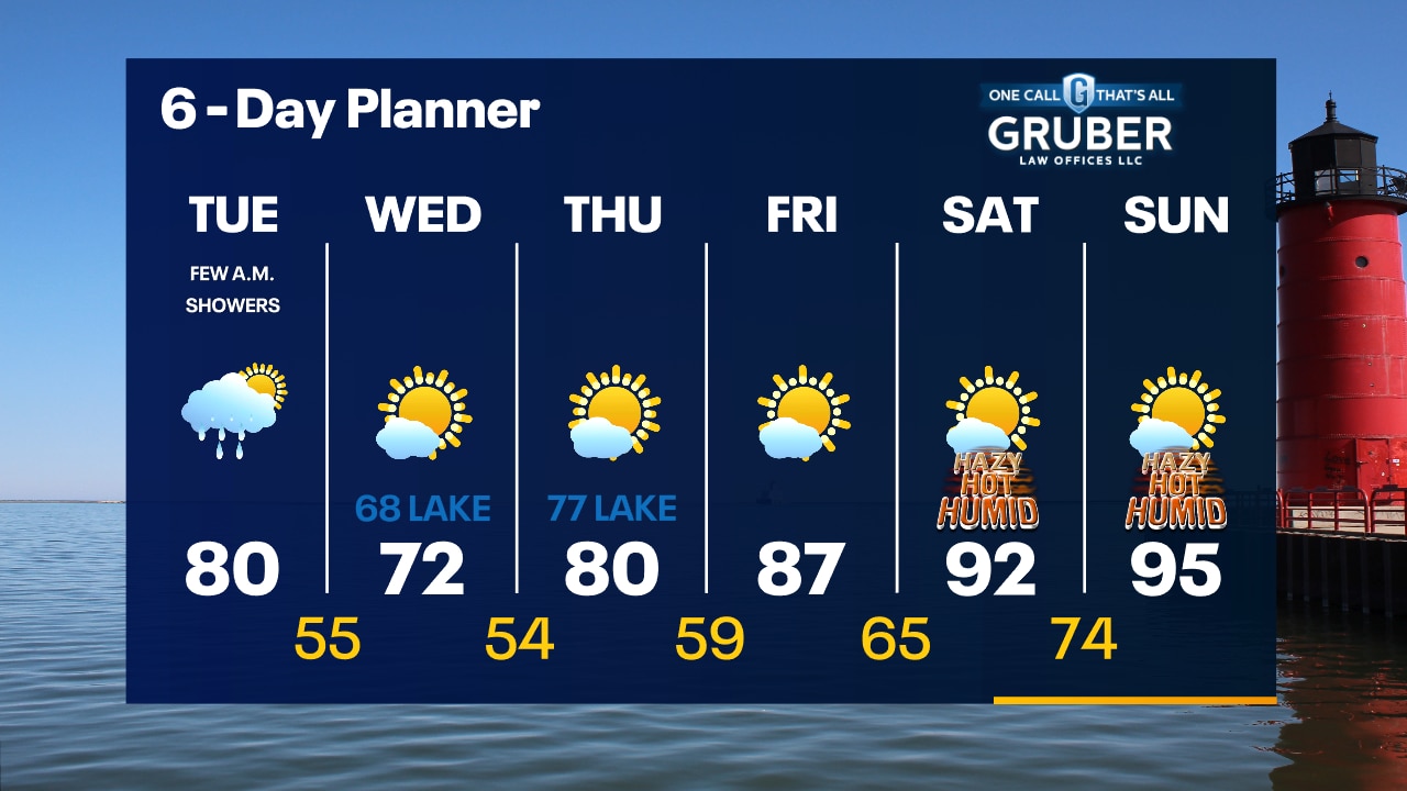
A few showers with a slight chance for a thunderstorm today as a cold front passes through Wisconsin - exiting our area late afternoon and early evening. As that front passes, we can expect the wind to turn to the NE and become stronger briefly. Highs will get to near 80 and fall rapidly behind the front. The strong NE wind will trigger a Beach Hazards Statement for the entire shoreline today. Stay out of Lake Michigan. We stay dry the remainder of the week and start to warm up again with 90s returning by the weekend.
A few showers with a slight chance for a thunderstorm today as a cold front passes through Wisconsin - exiting our area late afternoon and early evening. As that front passes, we can expect the wind to turn to the NE and become stronger briefly. Highs will get to near 80 and fall rapidly behind the front. The strong NE wind will trigger a Beach Hazards Statement for the entire shoreline today. Stay out of Lake Michigan. We stay dry the remainder of the week and start to warm up again with 90s returning by the weekend.
Weather Webcast with Tom Wachs
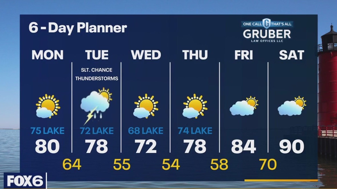
A few spotty showers overnight into the day Tuesday. The showers will be widely scattered. Highs around 80 midday, but dropping near the lake in the afternoon with gusty northeast winds kicking in.
A few spotty showers overnight into the day Tuesday. The showers will be widely scattered. Highs around 80 midday, but dropping near the lake in the afternoon with gusty northeast winds kicking in.
Weather Webcast with Tom Wachs
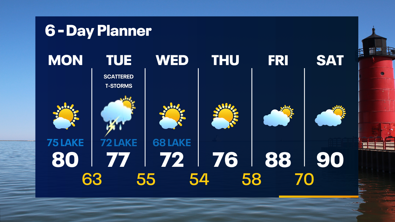
Partly cloudy tonight with temperatures dropping into the 60s. A few rain showers are possible overnight into Tuesday morning with a cold front. High around 80 on Tuesday, cooling near the lake in the afternoon.
Partly cloudy tonight with temperatures dropping into the 60s. A few rain showers are possible overnight into Tuesday morning with a cold front. High around 80 on Tuesday, cooling near the lake in the afternoon.

Weather Webcast With Lisa Michaels
A calm and clear day today with a sunny high in the upper 70s but cooler near the lake with the breeze shifting the southeast in the afternoon. We will be tracking a cold front overnight into Tuesday that will bring more clouds and showers. There is a slight chance for thunderstorms as this front passes. We resume dry conditions Wednesday through the weekend and may not see significant rain again until we are several days into the new month. Heat returns for the weekend with a long stretch of hot weather possible in the first few days of September.
A calm and clear day today with a sunny high in the upper 70s but cooler near the lake with the breeze shifting the southeast in the afternoon. We will be tracking a cold front overnight into Tuesday that will bring more clouds and showers. There is a slight chance for thunderstorms as this front passes. We resume dry conditions Wednesday through the weekend and may not see significant rain again until we are several days into the new month. Heat returns for the weekend with a long stretch of hot weather possible in the first few days of September.
Weather webcast with Rob Haswell
A calm and clear day today with a sunny high in the upper 70s but cooler near the lake with the breeze shifting the southeast in the afternoon. We will be tracking a cold front overnight into Tuesday that will bring more clouds and showers. There is a slight chance for thunderstorms as this front passes. We resume dry conditions Wednesday through the weekend and may not see significant rain again until we are several days into the new month. Heat returns for the weekend with a long stretch of hot weather possible in the first few days of September.
A calm and clear day today with a sunny high in the upper 70s but cooler near the lake with the breeze shifting the southeast in the afternoon. We will be tracking a cold front overnight into Tuesday that will bring more clouds and showers. There is a slight chance for thunderstorms as this front passes. We resume dry conditions Wednesday through the weekend and may not see significant rain again until we are several days into the new month. Heat returns for the weekend with a long stretch of hot weather possible in the first few days of September.

Weather Webcast with Tom Wachs
Clear skies overnight with temperatures in the 50s. Mostly sunny on Monday with highs around 80 inland, 70s near the lake.
Clear skies overnight with temperatures in the 50s. Mostly sunny on Monday with highs around 80 inland, 70s near the lake.
Weather Webcast with Tom Wachs
Clear and comfortable tonight with temperatures dropping into the 60s this evening and 50s overnight. Mostly sunny on Monday with highs around 80 inland, mid-70s near the lake.
Clear and comfortable tonight with temperatures dropping into the 60s this evening and 50s overnight. Mostly sunny on Monday with highs around 80 inland, mid-70s near the lake.
Weather Webcast with Meteorologist Lisa Michaels
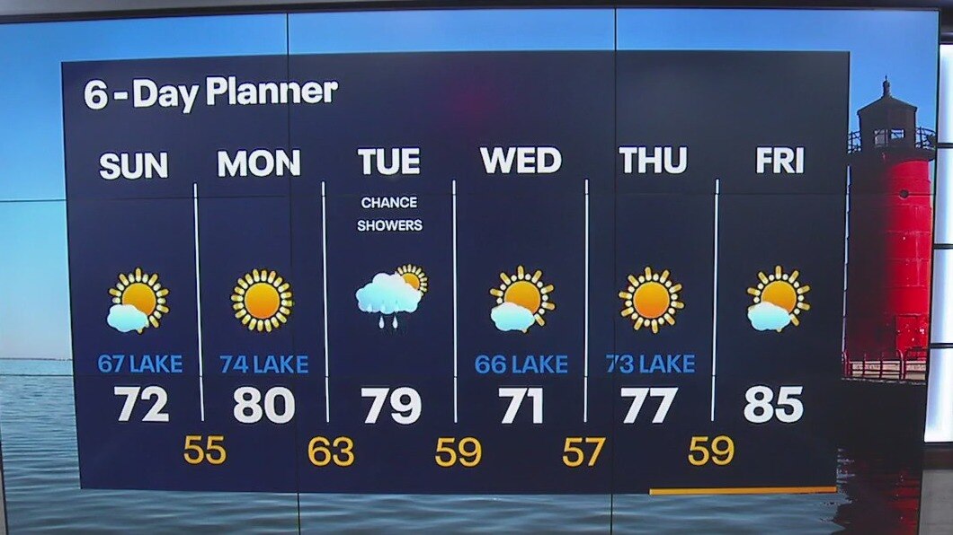
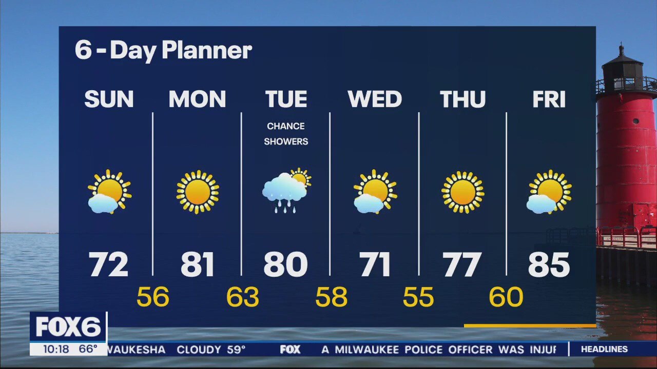
Clouds will gradually decrease this morning with more sunshine by the afternoon. Highs in the upper 60s lakeside to low 70s inland. More 70s in the forecast for the majority of next week. Nice and clear Monday and for a majority of Tuesday with a slight chance of rain Tuesday morning.
Clouds will gradually decrease this morning with more sunshine by the afternoon. Highs in the upper 60s lakeside to low 70s inland. More 70s in the forecast for the majority of next week. Nice and clear Monday and for a majority of Tuesday with a slight chance of rain Tuesday morning.
Weather Webcast with Meteorologist Eric Manges
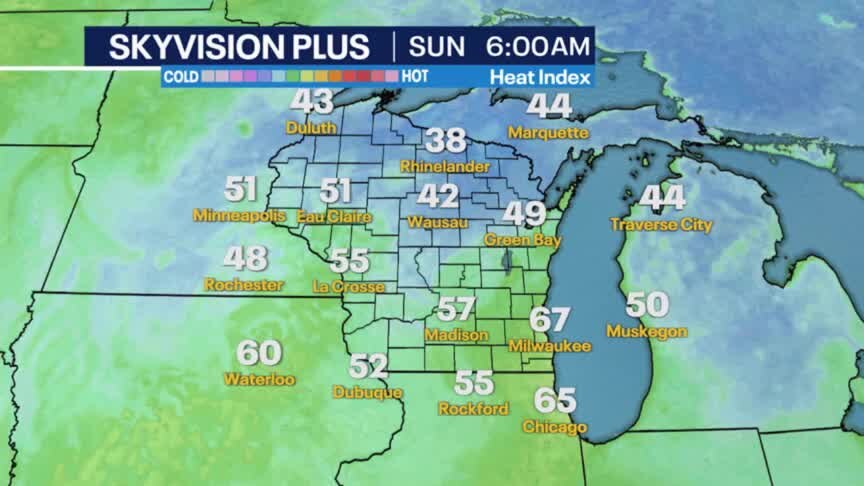
Sunshine for Sunday and Monday and only scattered rain chances in the forecast for Tuesday
Sunshine for Sunday and Monday and only scattered rain chances in the forecast for Tuesday
Weather Webcast with Meteorologist Eric Manges
Cooler air and beautiful conditions to start the work week
Cooler air and beautiful conditions to start the work week