

Weather webcast with Rob Haswell
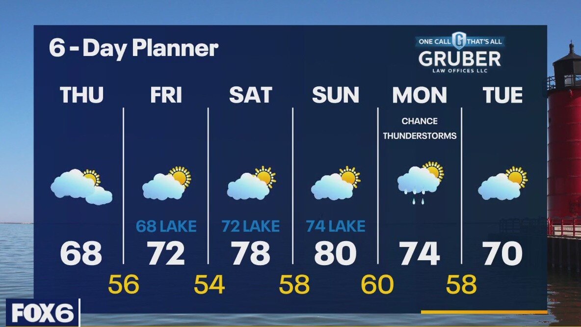
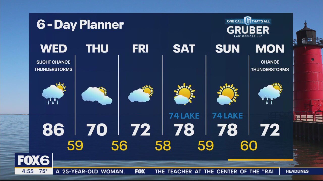
High pressure builds in today along with cooler and far less humid air. Temperatures fall into the mid to upper 60s this afternoon. We stay cloudy most of the day and clear overnight into Friday. Friday's highs will be slightly warmer - in the low 70s. We should return to the upper 70s and near 80 this weekend but a steady wind off the lake will keep us in the low 70s near Lake Michigan. Our next chance for rain arrives Monday and Tuesday.
High pressure builds in today along with cooler and far less humid air. Temperatures fall into the mid to upper 60s this afternoon. We stay cloudy most of the day and clear overnight into Friday. Friday's highs will be slightly warmer - in the low 70s. We should return to the upper 70s and near 80 this weekend but a steady wind off the lake will keep us in the low 70s near Lake Michigan. Our next chance for rain arrives Monday and Tuesday.
Weather Webcast with Tom Wachs
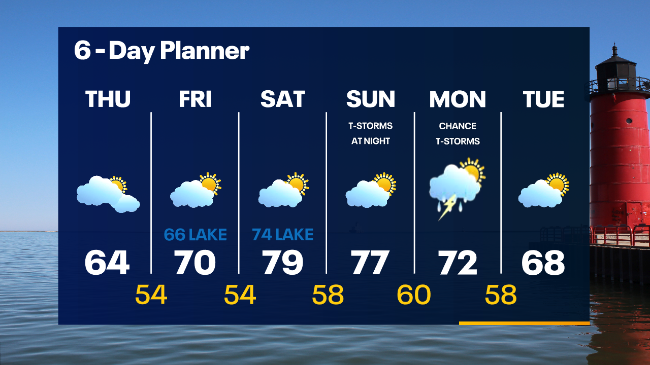
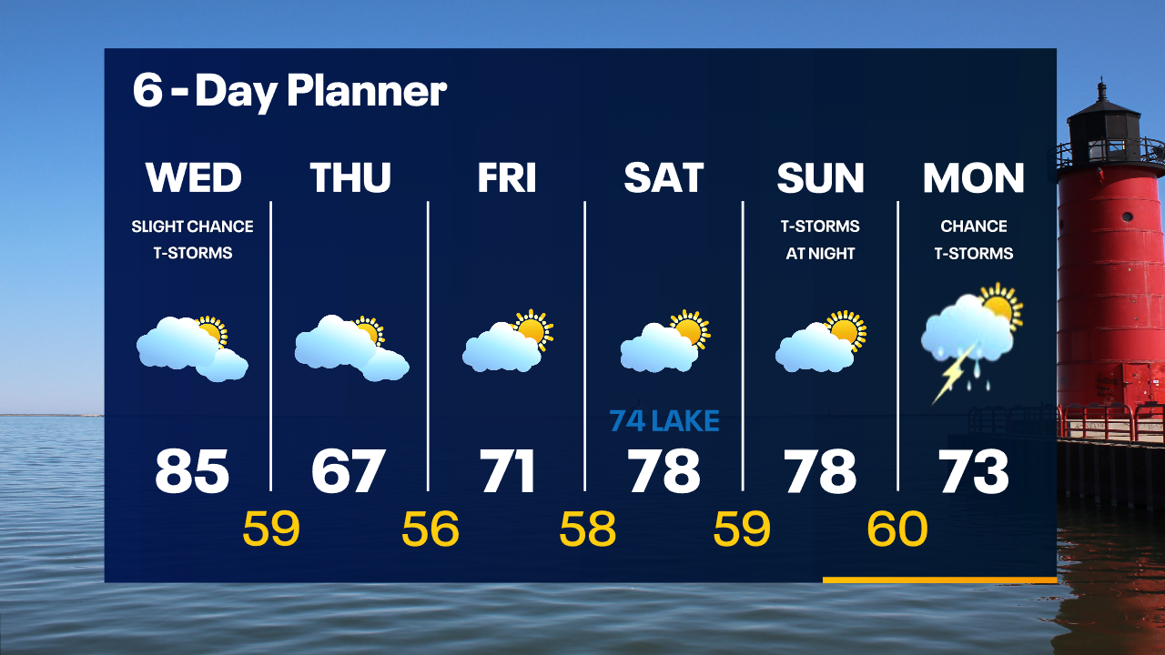
Scattered showers will come to an end overnight. Temperatures drop into the upper 50s by sunrise. Much cooler and less humid on Thursday with highs struggling to reach 65.
Scattered showers will come to an end overnight. Temperatures drop into the upper 50s by sunrise. Much cooler and less humid on Thursday with highs struggling to reach 65.
Weather Webcast with Tom Wachs
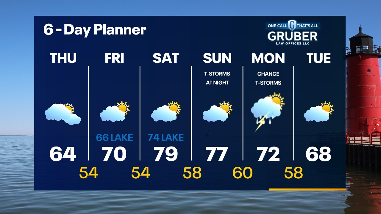
Scattered showers/t-storms will end late this evening. A big cool down comes in overnight. Much cooler and less humid on Thursday with highs in the low-to-mid 60s.
Scattered showers/t-storms will end late this evening. A big cool down comes in overnight. Much cooler and less humid on Thursday with highs in the low-to-mid 60s.
Weather Webcast with Stephanie Barichello
Scattered showers and a few t-storms will be possible this afternoon and evening, plus hot and humid with highs in the 80s. Much cooler and more comfortable the rest of the week with temperatures in the 60s and 70s. Sunshine returns Friday and over the weekend.
Scattered showers and a few t-storms will be possible this afternoon and evening, plus hot and humid with highs in the 80s. Much cooler and more comfortable the rest of the week with temperatures in the 60s and 70s. Sunshine returns Friday and over the weekend.
Weather webcast with Rob Haswell
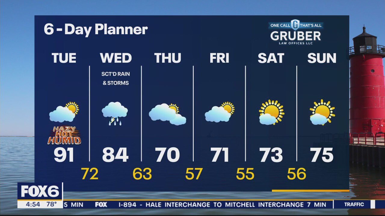
A low passing over our area today gives us a chance for a few showers and thunderstorms today and tonight.
A low passing over our area today gives us a chance for a few showers and thunderstorms today and tonight.
Weather Webcast with Tom Wachs
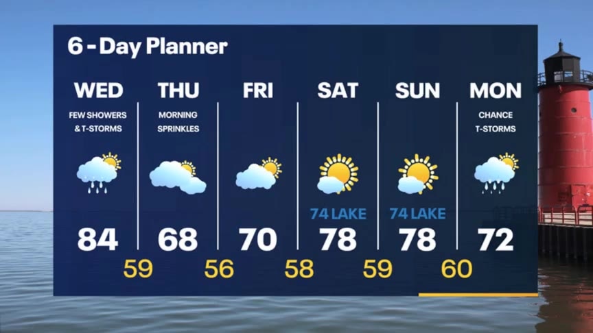
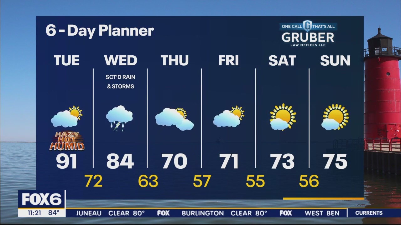
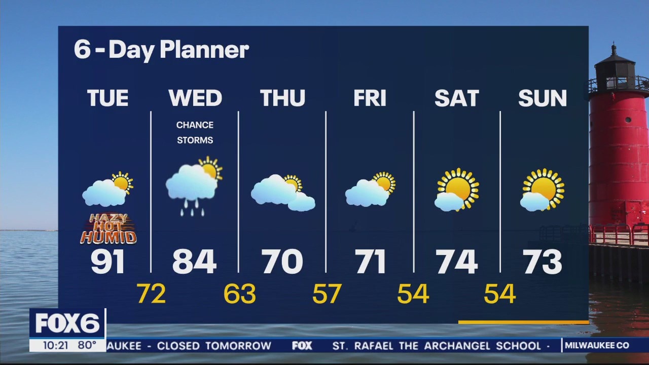
A few t-storms are possible overnight and again on Wednesday. The heat/humidity will be with us one more day on Wednesday before a big drop on Thursday.
A few t-storms are possible overnight and again on Wednesday. The heat/humidity will be with us one more day on Wednesday before a big drop on Thursday.
Weather Webcast with Tom Wachs
Humid tonight with scattered t-storms overnight. Temperatures in the 70s. Mostly cloudy and humid again on Wednesday with highs in the 80s. Slight chance for a t-storm.
Humid tonight with scattered t-storms overnight. Temperatures in the 70s. Mostly cloudy and humid again on Wednesday with highs in the 80s. Slight chance for a t-storm.
Weather Webcast with Meteorologist Eric Manges
Finally cooler air in the forecast with rain potential Wednesday
Finally cooler air in the forecast with rain potential Wednesday
Weather webcast with Lisa Michaels
Sticky conditions with a moist air mass over us. Highs back in the low 90s this afternoon.
Sticky conditions with a moist air mass over us. Highs back in the low 90s this afternoon.
Weather Webcast with Meteorologist Eric Manges
Hot again Tuesday and rain potential come Wednesday
Hot again Tuesday and rain potential come Wednesday

Weather Webcast with Meteorologist Eric Manges
One more day of 90s then finally rain and seasonable temperatures to end the week
One more day of 90s then finally rain and seasonable temperatures to end the week

Weather Webcast with Meteorologist Lisa Michaels
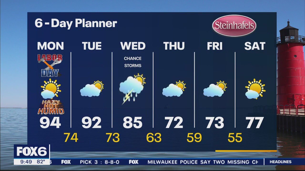
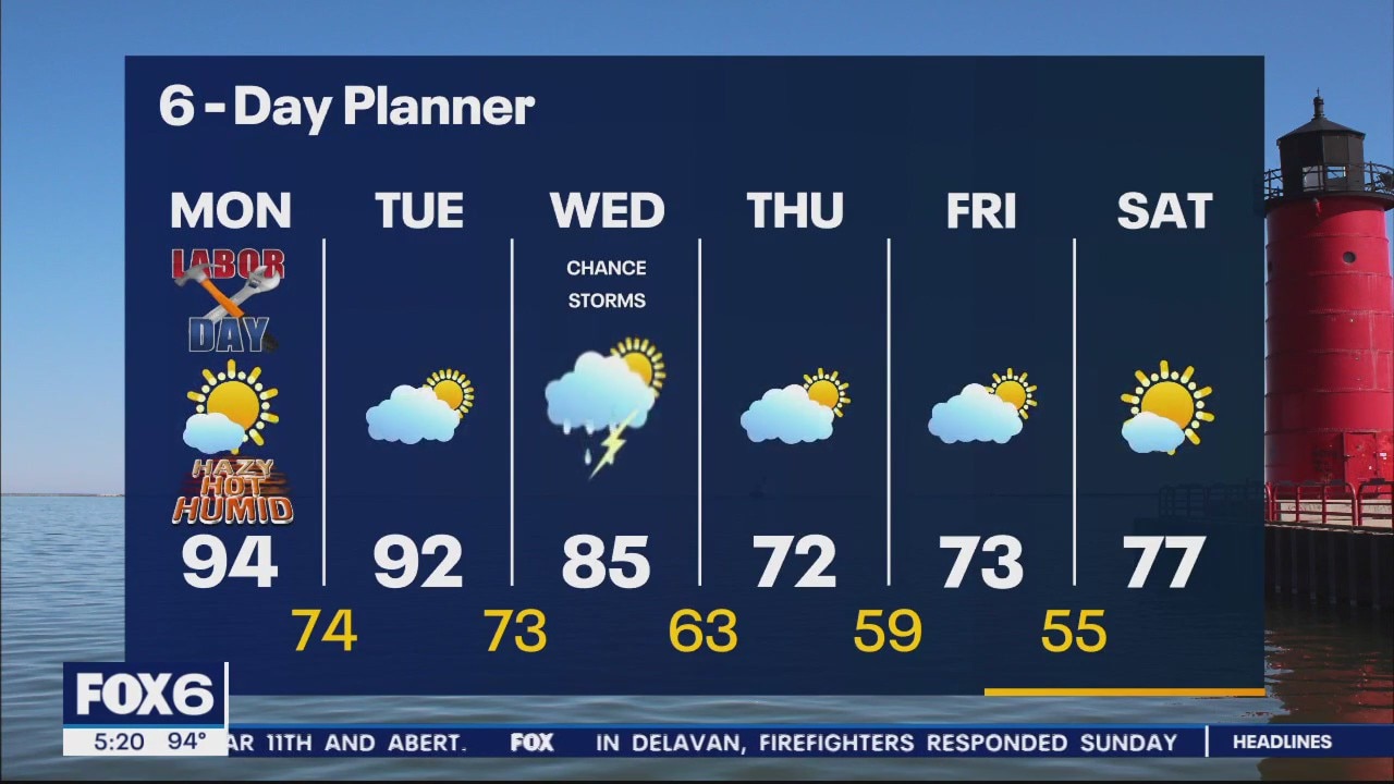
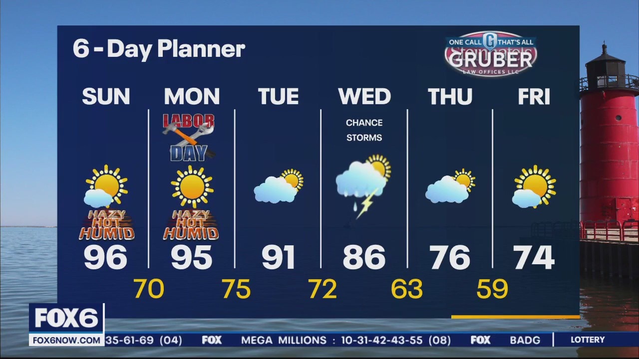
Low to mid 90s on Labor Day. Potentially could break record high temps today. It will feel more humid this afternoon. Better source of moisture will make it feel sticky through Wednesday. Rain and storm chances Wednesday. There is the potential of a few strong storms.
Low to mid 90s on Labor Day. Potentially could break record high temps today. It will feel more humid this afternoon. Better source of moisture will make it feel sticky through Wednesday. Rain and storm chances Wednesday. There is the potential of a few strong storms.
Weather Webcast with Meteorologist Eric Manges
Heat is still on to start the week but cooler air is on the horizon
Heat is still on to start the week but cooler air is on the horizon
Weather Webcast with Meteorologist Eric Manges
Record tying high temperatures Sunday with another shot at record highs on Monday
Record tying high temperatures Sunday with another shot at record highs on Monday

Weather Webcast with Meteorologist Lisa Michaels
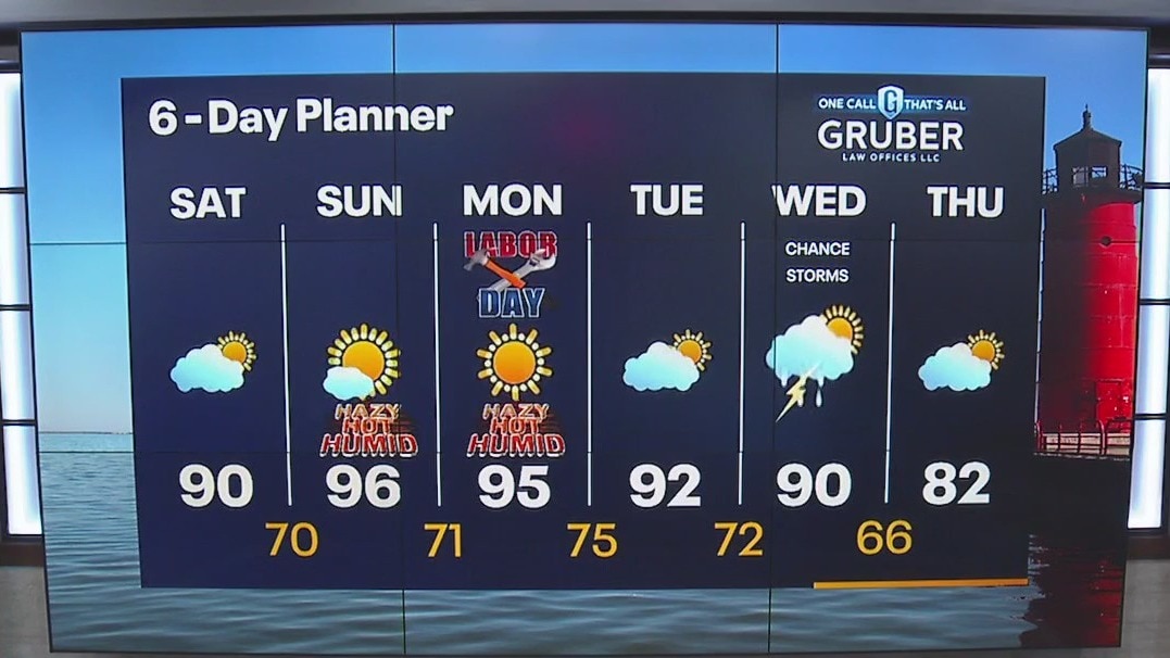
Mid 90s will be the theme the next couple of days with a good chance at setting new record highs. Better source of moisture will make it feel sticky late Monday through Wednesday. Highs still in the low 90s. Rain potential finally by Wednesday as scattered showers move in with a chance for storms.
Mid 90s will be the theme the next couple of days with a good chance at setting new record highs. Better source of moisture will make it feel sticky late Monday through Wednesday. Highs still in the low 90s. Rain potential finally by Wednesday as scattered showers move in with a chance for storms.
Weather Webcast with Meteorologist Eric Manges
Heat is on Sunday and Monday with temperatures getting to record levels potentially
Heat is on Sunday and Monday with temperatures getting to record levels potentially
Weather Webcast with Meteorologist Lisa Michaels
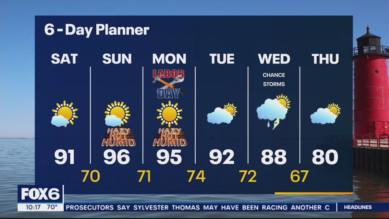
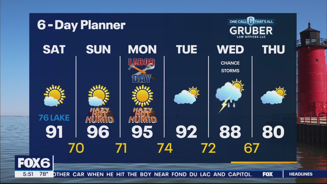
Mostly sunny to partly cloudy skies Saturday. Highs in the upper 80s to low 90s. Slight chance of a shower/storm north. Temps continue to climb further into the holiday weekend. Mid 90s on Sunday and Monday as the hottest days. Potential record high temps are possible Sunday through Tuesday.
Mostly sunny to partly cloudy skies Saturday. Highs in the upper 80s to low 90s. Slight chance of a shower/storm north. Temps continue to climb further into the holiday weekend. Mid 90s on Sunday and Monday as the hottest days. Potential record high temps are possible Sunday through Tuesday.
Weather Webcast with Meteorologist Eric Manges
Heat is on this weekend but rain still not looking likely until at least Wednesday
Heat is on this weekend but rain still not looking likely until at least Wednesday
Weather Webcast with Meteorologist Eric Manges
Record high temperatures possible Sunday, Monday, and possibly Tuesday but fortunately not as muggy as our last heat wave
Record high temperatures possible Sunday, Monday, and possibly Tuesday but fortunately not as muggy as our last heat wave
Weather Webcast With Lisa Michaels
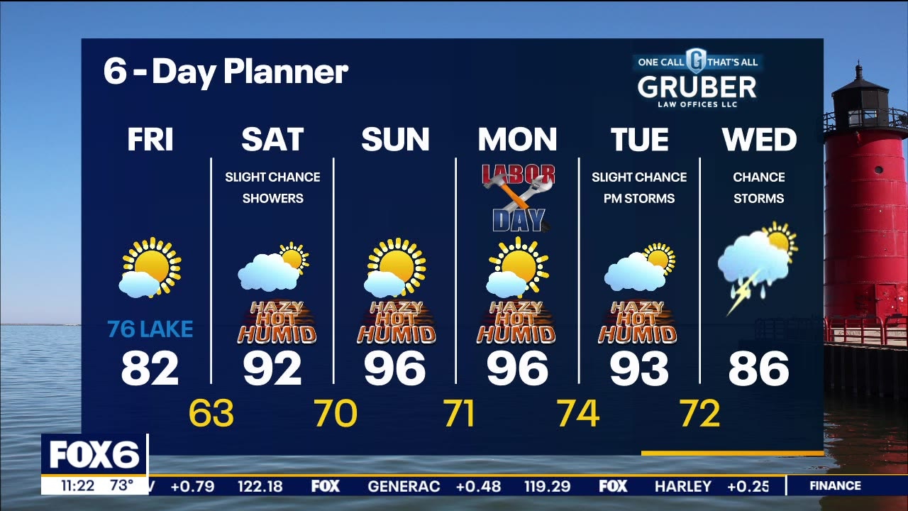
Mostly sunny, breezy and warmer on Friday. Highs in the low to mid-80s inland,mid-70s near the lake. Windy, hot and humid this weekend. Highs in the low-to-mid 90s for the holiday weekend and into Tuesday. The afternoon heat index will be upper 90s to maybe low 100F. Record highs could be broken this weekend as well. A cold front will come through Wednesday which will start to cool us down later in the week. Small chance of rain Saturday with better chances arriving next week.
Mostly sunny, breezy and warmer on Friday. Highs in the low to mid-80s inland,mid-70s near the lake. Windy, hot and humid this weekend. Highs in the low-to-mid 90s for the holiday weekend and into Tuesday. The afternoon heat index will be upper 90s to maybe low 100F. Record highs could be broken this weekend as well. A cold front will come through Wednesday which will start to cool us down later in the week. Small chance of rain Saturday with better chances arriving next week.