

Weather webcast with Rob Haswell
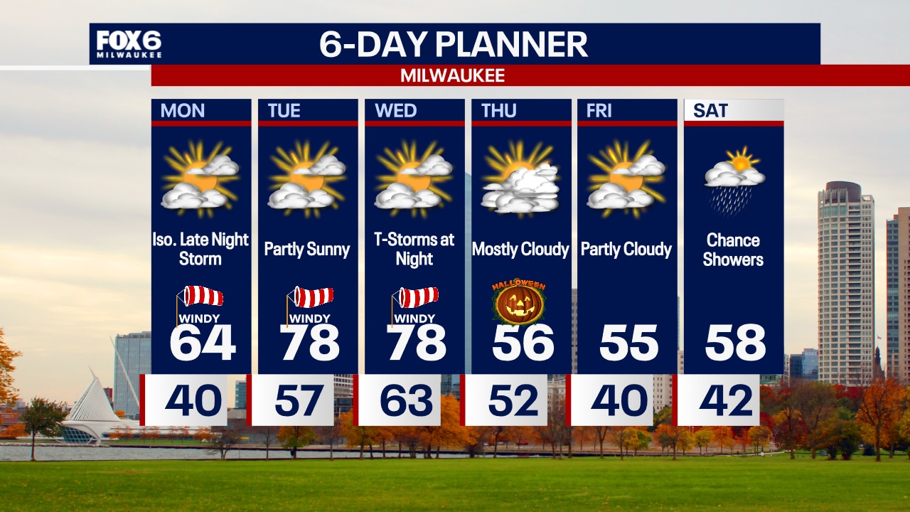
Another very warm and very windy day with highs near 80 and wind speeds 15-25 mph gusting to 40! An approaching cold front will bring some rain and a chance for thunderstorms overnight and eventually cool things down on Thursday.
Another very warm and very windy day with highs near 80 and wind speeds 15-25 mph gusting to 40! An approaching cold front will bring some rain and a chance for thunderstorms overnight and eventually cool things down on Thursday.
Weather webcast with Lisa Michaels
Mostly cloudy skies tonight with mild temperatures holding in the mid 60s. Windy conditions persist. Partly sunny on Wednesday with another chance at breaking record high temps. Very windy with gusts up to 40mph that can continue through Thursday.
Mostly cloudy skies tonight with mild temperatures holding in the mid 60s. Windy conditions persist. Partly sunny on Wednesday with another chance at breaking record high temps. Very windy with gusts up to 40mph that can continue through Thursday.
Weather Webcast with Stephanie Barichello
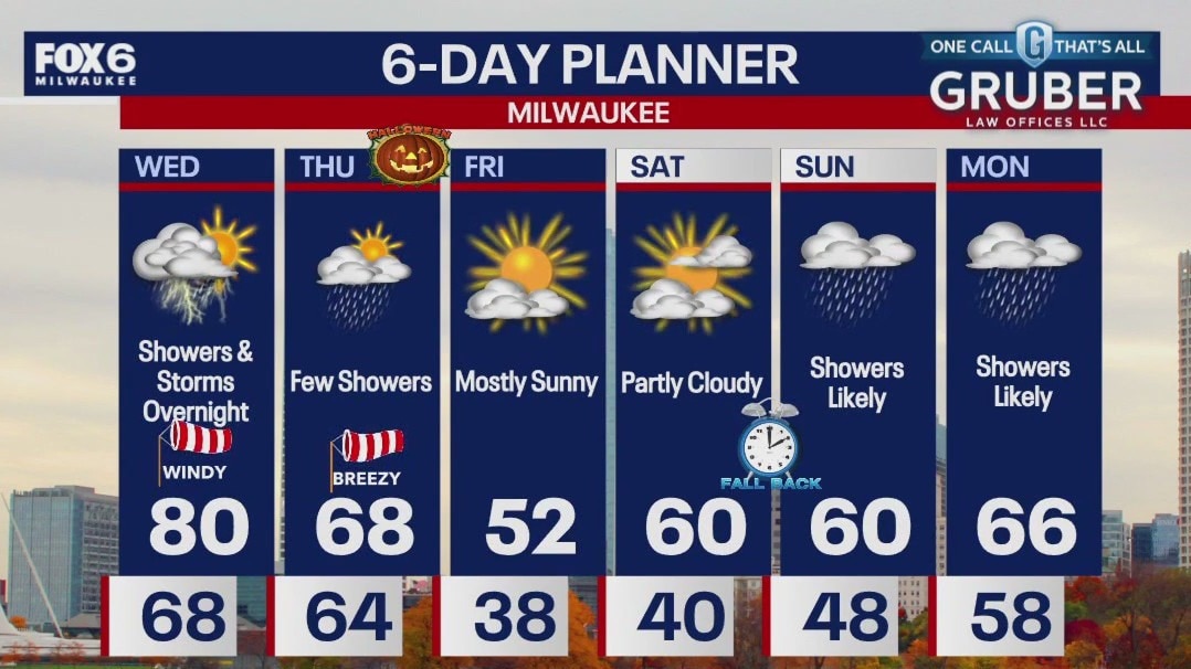
Windy and warm this evening with temperatures falling into the 60s. Back to around 80 on Wednesday and windy, then showers and thunderstorms move in at night. Lingering showers Thursday morning, then dropping temperatures in the afternoon. Windy and chilly for evening trick-or-treating!
Windy and warm this evening with temperatures falling into the 60s. Back to around 80 on Wednesday and windy, then showers and thunderstorms move in at night. Lingering showers Thursday morning, then dropping temperatures in the afternoon. Windy and chilly for evening trick-or-treating!
Weather Webcast with Chief Meteorologist Rob Haswell
Another windy and warm day with a steady wind from the southwest helping to deliver some very summer-like air. Highs today will reach the low 80s and could meet or beat the record high for the date. Highs will again be near 80 tomorrow.
Another windy and warm day with a steady wind from the southwest helping to deliver some very summer-like air. Highs today will reach the low 80s and could meet or beat the record high for the date. Highs will again be near 80 tomorrow.

Weather Webcast with Chief Meteorologist Tom Wachs
Windy overnight with temperatures rising into the 60s. Partly sunny and very windy on Tuesday with a near-record high around 80.
Windy overnight with temperatures rising into the 60s. Partly sunny and very windy on Tuesday with a near-record high around 80.

Weather Webcast with Chief Meteorologist Tom Wachs
Mostly cloudy and windy tonight with rising temperatures overnight. Partly sunny and very windy on Tuesday with a near-record high around 80.
Mostly cloudy and windy tonight with rising temperatures overnight. Partly sunny and very windy on Tuesday with a near-record high around 80.

Weather Webcast with Stephanie Barichello
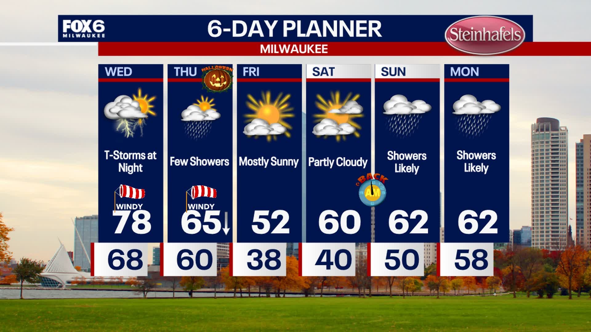
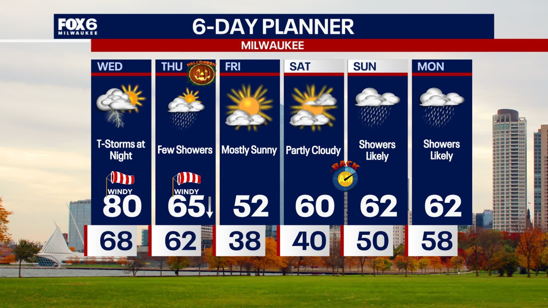
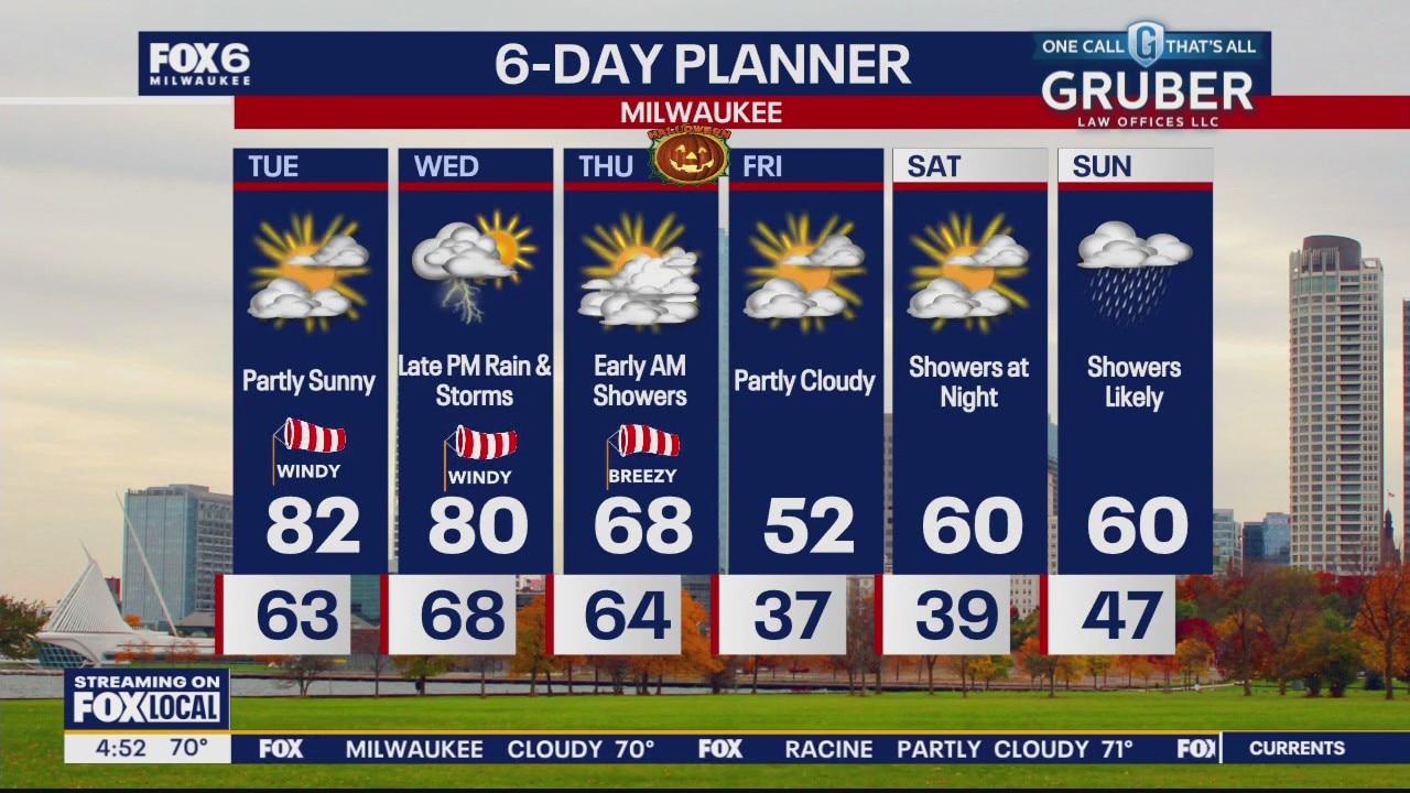
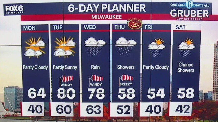
More clouds than sun today and breezy, then very windy and warm Tuesday into Wednesday. We'll be flirting with record highs in the upper 70s and low 80s. A cold front swings through Wednesday night bringing rain and thunder through Thursday morning, then expect a cooler Halloween with highs in the 50s. Staying cool through the weekend.
More clouds than sun today and breezy, then very windy and warm Tuesday into Wednesday. We'll be flirting with record highs in the upper 70s and low 80s. A cold front swings through Wednesday night bringing rain and thunder through Thursday morning, then expect a cooler Halloween with highs in the 50s. Staying cool through the weekend.
Weather webcast with Rob Haswell
A seasonally mild day on tap to kick off the last week of October but even warmer air is on tap tomorrow. Highs today will reach the low 60s which is 6-10 degrees above the climate average but we could be in for record heat near 80 for Tuesday and again Wednesday.
A seasonally mild day on tap to kick off the last week of October but even warmer air is on tap tomorrow. Highs today will reach the low 60s which is 6-10 degrees above the climate average but we could be in for record heat near 80 for Tuesday and again Wednesday.

Weather Webcast with Chief Meteorologist Tom Wachs
Partly cloudy overnight with patchy frost possible inland. Temperatures in the upper 30s to around 40 by sunrise. Partly sunny and windy on Monday with highs in the mid-60s.
Partly cloudy overnight with patchy frost possible inland. Temperatures in the upper 30s to around 40 by sunrise. Partly sunny and windy on Monday with highs in the mid-60s.
Weather Webcast with Tom Wachs
Partly cloudy tonight with temperatures dropping through the 40s. Patchy frost is possible inland overnight. Partly sunny and windy on Monday with highs in the mid-60s.
Partly cloudy tonight with temperatures dropping through the 40s. Patchy frost is possible inland overnight. Partly sunny and windy on Monday with highs in the mid-60s.

Weather webcast with Lisa Michaels
Morning frost across southeast Wisconsin away from the lake. It'll melt quickly as the sun rises and temperatures warm into the upper 50s to 60s. A rather large warming trend will return next week with high temps reaching the upper 70s on Tuesday and Wednesday.
Morning frost across southeast Wisconsin away from the lake. It'll melt quickly as the sun rises and temperatures warm into the upper 50s to 60s. A rather large warming trend will return next week with high temps reaching the upper 70s on Tuesday and Wednesday.

Weather Webcast with Holly Baker
Temperature remain seasonable for the weekend.
Temperature remain seasonable for the weekend.

Weather webcast with Lisa Michaels
Mostly sunny Saturday with highs in the mid 50s. Frost is possible inland on Sunday. Mostly sunny and slightly warmer in the low 60s with southerly winds returning.
Mostly sunny Saturday with highs in the mid 50s. Frost is possible inland on Sunday. Mostly sunny and slightly warmer in the low 60s with southerly winds returning.

Weather Webcast with Holly Baker
Nice and dry over the weekend.
Nice and dry over the weekend.
Weather webcast with Lisa Michaels
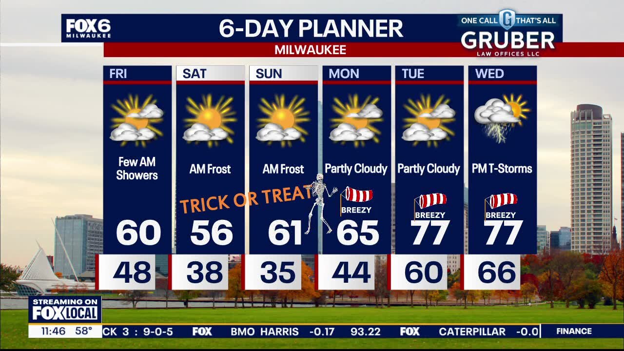
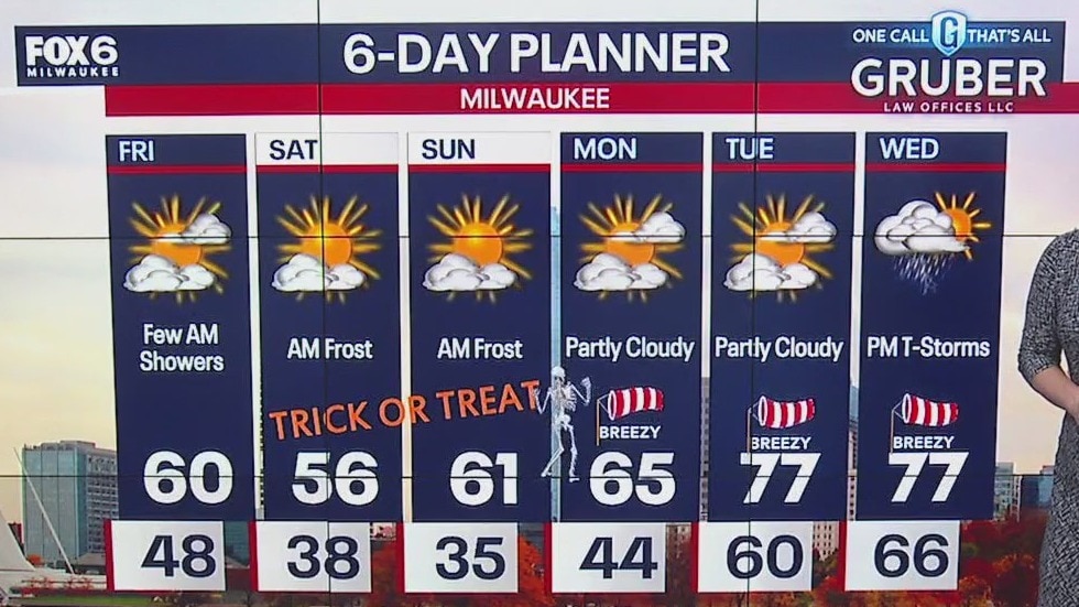
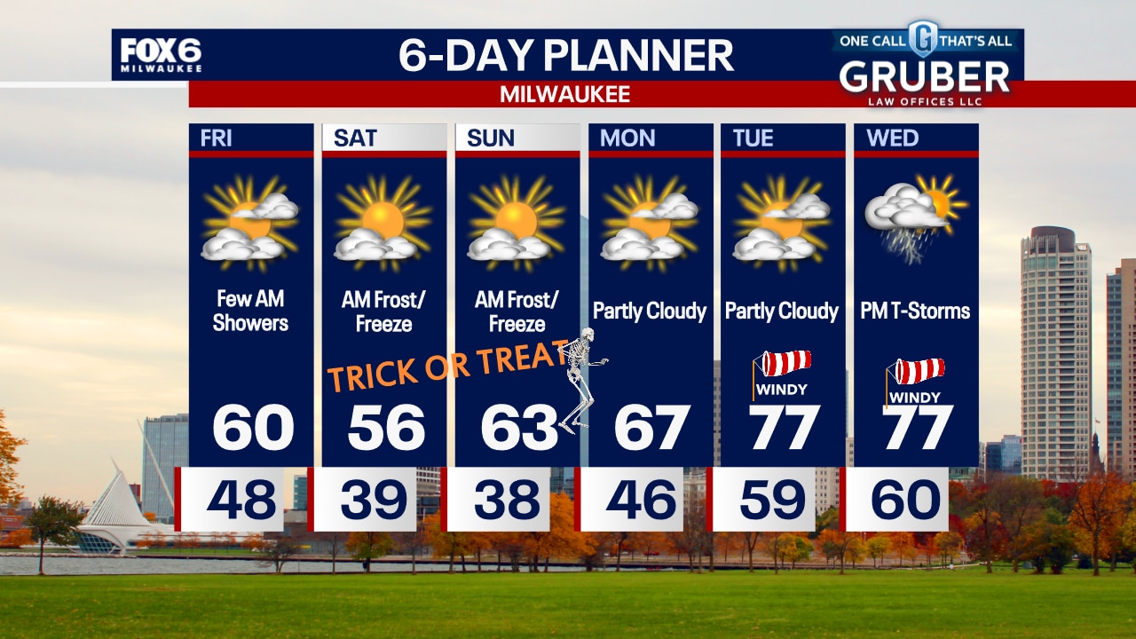
Partly Cloudy to mostly sunny skies with highs in the upper 50s to low 60s. Possible frost inland both Saturday and Sunday mornings as cool air returns. Seasonably cool Saturday in the 50s, then around 60 on Sunday. Dry and sunny for any trick-or-treating! Gradually warming next week, with a few days in the upper 70s. A system will bring rain/storms by Wednesday afternoon, which will cool temperatures on Halloween.
Partly Cloudy to mostly sunny skies with highs in the upper 50s to low 60s. Possible frost inland both Saturday and Sunday mornings as cool air returns. Seasonably cool Saturday in the 50s, then around 60 on Sunday. Dry and sunny for any trick-or-treating! Gradually warming next week, with a few days in the upper 70s. A system will bring rain/storms by Wednesday afternoon, which will cool temperatures on Halloween.
Weather webcast with Lisa Michaels
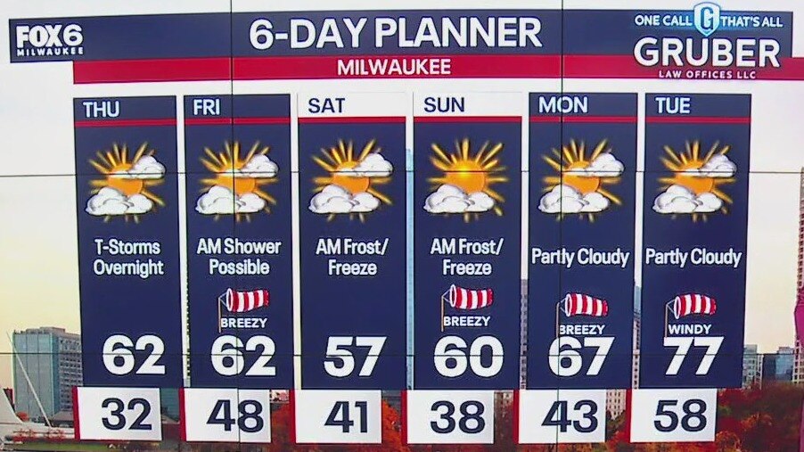
Showers ending early Friday morning. Cloudy to start the day with decreasing clouds and partly cloudy by the afternoon. Highs in the upper 50s to low 60s. Possible frost inland both Saturday and Sunday mornings as cool air returns.
Showers ending early Friday morning. Cloudy to start the day with decreasing clouds and partly cloudy by the afternoon. Highs in the upper 50s to low 60s. Possible frost inland both Saturday and Sunday mornings as cool air returns.

Weather Webcast with Tom Wachs
Showers and a few t-storms overnight. The heaviest rain will fall from 1am-5am with rain tapering off around 8am. Overnight temperatures in the upper 40s. Becoming partly sunny on Friday, breezy with a high around 60.
Showers and a few t-storms overnight. The heaviest rain will fall from 1am-5am with rain tapering off around 8am. Overnight temperatures in the upper 40s. Becoming partly sunny on Friday, breezy with a high around 60.
Weather Webcast with Chief Meteorologist Tom Wachs
Rain and a few rumbles from 11pm-8am. 0.25"-0.50" of rain possible. Gradual clearing on Friday. Breezy with highs around 60.
Rain and a few rumbles from 11pm-8am. 0.25"-0.50" of rain possible. Gradual clearing on Friday. Breezy with highs around 60.
Weather webcast with Holly Baker
A cold start to Thursday morning. Mostly sunny for Thursday with temperatures warming up to the low 60's. Increasing clouds and storms are expected Thursday overnight.
A cold start to Thursday morning. Mostly sunny for Thursday with temperatures warming up to the low 60's. Increasing clouds and storms are expected Thursday overnight.

Weather Webcast with Chief Meteorologist Tom Wachs
A frost is expected across the area overnight and a freeze away from the lake. Partly sunny on Thursday with highs in the low 60s. Showers and t-storms are likely late Thursday night.
A frost is expected across the area overnight and a freeze away from the lake. Partly sunny on Thursday with highs in the low 60s. Showers and t-storms are likely late Thursday night.