

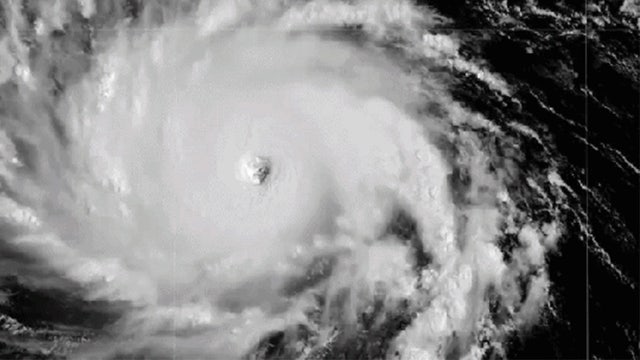

Category 4 Hurricane Lowell turning toward Hawaii, threatening to slam the islands with heavy rain, high surf
Hurricane Lowell is churning as a Category 4 hurricane about 600 miles south of Kauaʻi, packing maximum sustained winds of 155 mph.
Hurricane Lowell is churning as a Category 4 hurricane about 600 miles south of Kauaʻi, packing maximum sustained winds of 155 mph.
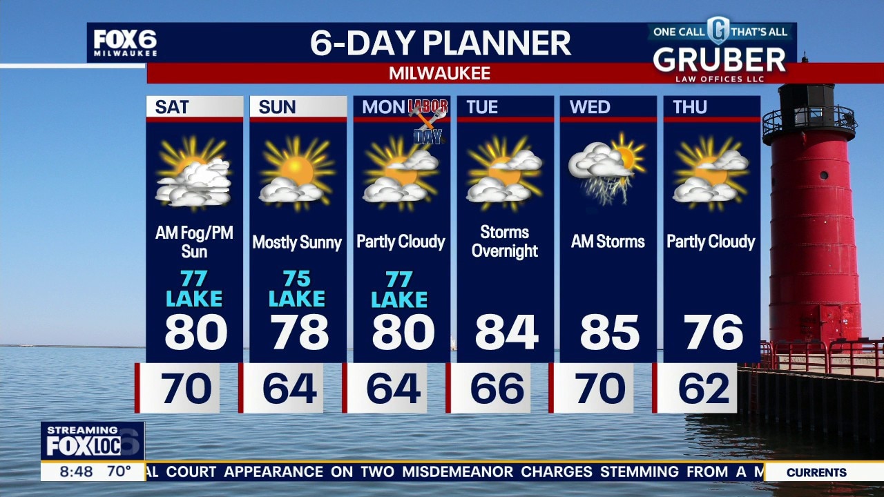
Milwaukee weather: Clearing clouds and dropping dewpoints
Becoming partly sunny today, then clearing overnight. Sunshine expected the rest of the holiday weekend. Dewpoints will finally drop Sunday with comfortable conditions through Labor Day. Heating up briefly midweek with a chance of storms.
Becoming partly sunny today, then clearing overnight. Sunshine expected the rest of the holiday weekend. Dewpoints will finally drop Sunday with comfortable conditions through Labor Day. Heating up briefly midweek with a chance of storms.
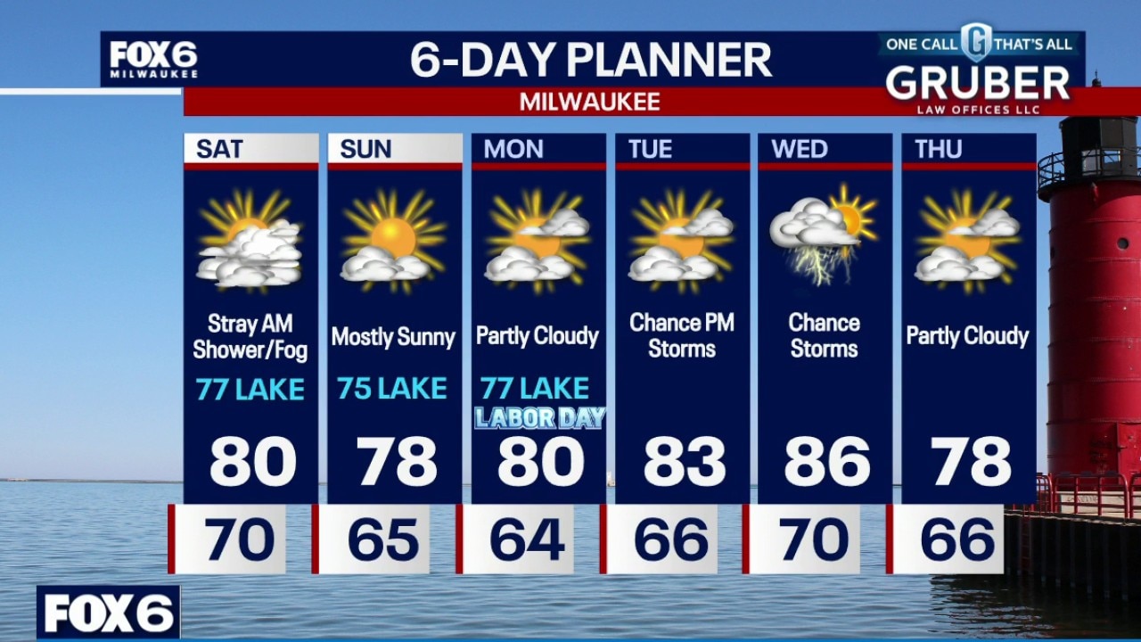
Milwaukee weather: Evening storm possible then dense fog
A few more thunderstorms are possible this evening, just at a more isolated rate. A stronger storm cannot be ruled out. Dense fog develops overnight and lingers Saturday. Sunshine returns Saturday afternoon, with beautiful conditions the rest of the weekend.
A few more thunderstorms are possible this evening, just at a more isolated rate. A stronger storm cannot be ruled out. Dense fog develops overnight and lingers Saturday. Sunshine returns Saturday afternoon, with beautiful conditions the rest of the weekend.


Milwaukee Weather: Stray evening storm, humid
Scattered storms Friday morning. Heavy rain, possible flooding, gusty winds, and small hail are the main threats. A stationary front lingers in southern Wisconsin on Friday. High temperatures in the mid-80s with humid conditions.
Scattered storms Friday morning. Heavy rain, possible flooding, gusty winds, and small hail are the main threats. A stationary front lingers in southern Wisconsin on Friday. High temperatures in the mid-80s with humid conditions.


Washington County house fire; caused by probable lightning strike
The Germantown Fire Department said a probable lightning strike sparked a house fire early Friday morning, Sept. 4, during thunderstorms.
The Germantown Fire Department said a probable lightning strike sparked a house fire early Friday morning, Sept. 4, during thunderstorms.


Wisconsin weather Friday; scattered storms and humid
Scattered storms Friday morning. Heavy rain, possible flooding, gusty winds, and small hail are the main threats. A stationary front lingers in southern Wisconsin on Friday.
Scattered storms Friday morning. Heavy rain, possible flooding, gusty winds, and small hail are the main threats. A stationary front lingers in southern Wisconsin on Friday.
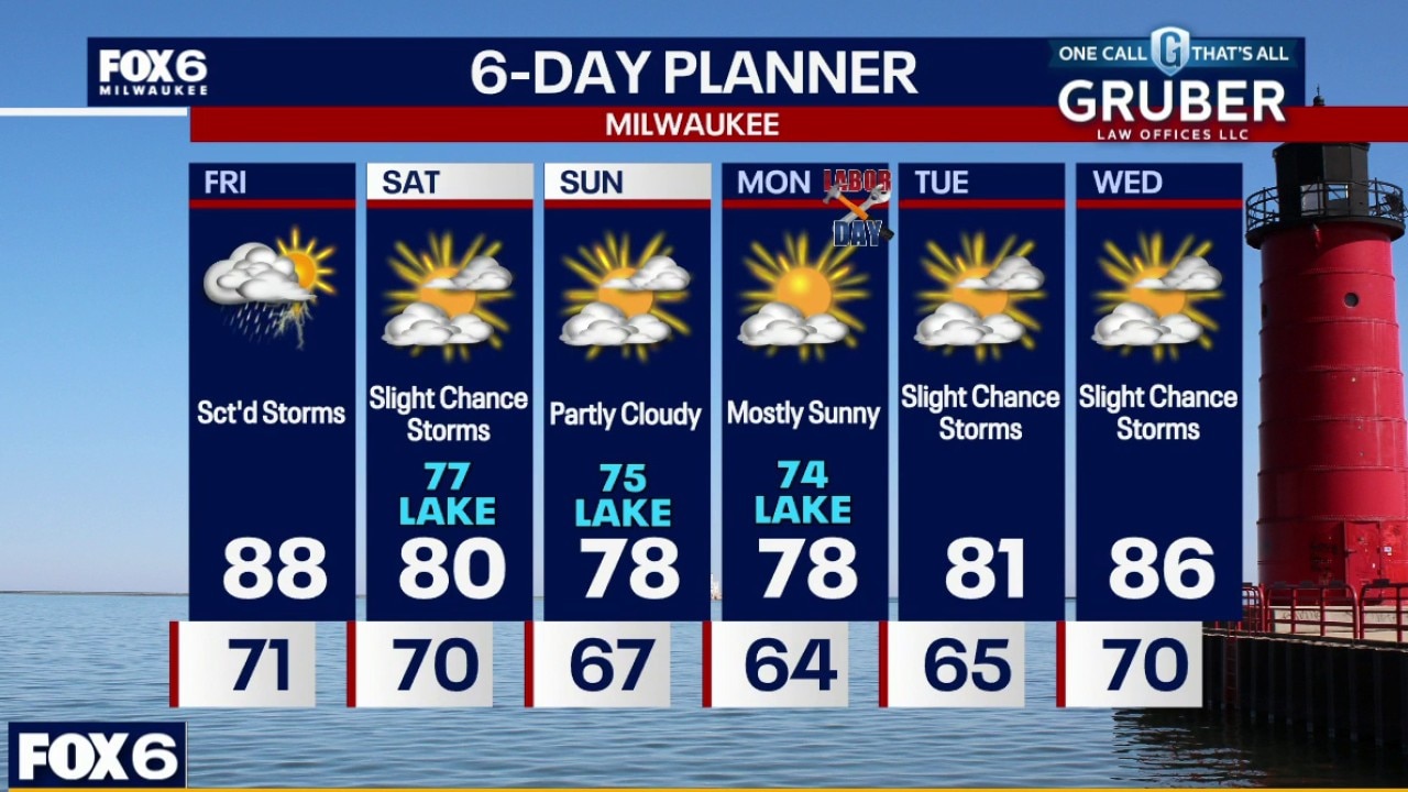
Milwaukee weather: Scattered storms and humid Friday
Scattered storms Friday morning. Heavy rain, possible flooding, gusty winds, and small hail are the main threats. A stationary front lingers in southern Wisconsin on Friday. High temperatures in the mid-80s with humid conditions.
Scattered storms Friday morning. Heavy rain, possible flooding, gusty winds, and small hail are the main threats. A stationary front lingers in southern Wisconsin on Friday. High temperatures in the mid-80s with humid conditions.
Milwaukee weather: Storms possible overnight, hot on Friday
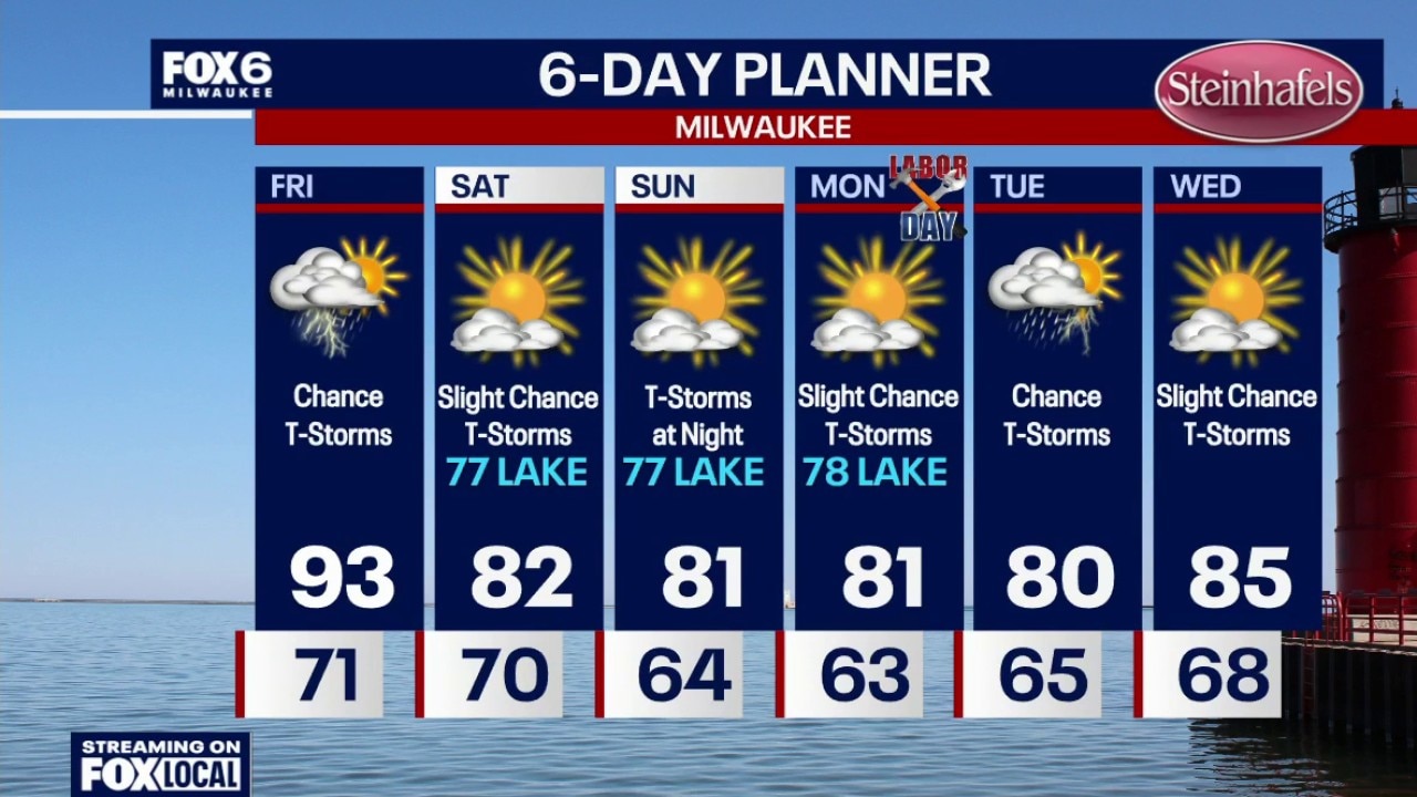
Another chance for t-storms overnight. Any storms could produce flooding, lightning, strong winds, hail and an isolated tornado. Areas of fog developing near the lake. Very hot and humid on Friday. Highs in the low-to-mid 90s with a heat index of 100. Scattered t-storms are also possible as this stationary front lingers across the area. Again, HOT and HUMID on Friday. The front moves south on Saturday, cooling us down AND dropping our dew points into the 60s. Only a slight chance for a t-storm on Saturday. Greater chances for storms on Sunday night. Highs in the 70s/80s.
Another chance for t-storms overnight. Any storms could produce flooding, lightning, strong winds, hail and an isolated tornado. Areas of fog developing near the lake. Very hot and humid on Friday. Highs in the low-to-mid 90s with a heat index of 100. Scattered t-storms are also possible as this stationary front lingers across the area. Again, HOT and HUMID on Friday. The front moves south on Saturday, cooling us down AND dropping our dew points into the 60s. Only a slight chance for a t-storm on Saturday. Greater chances for storms on Sunday night. Highs in the 70s/80s.
Storm damage in Richfield, cleanup continues into the night
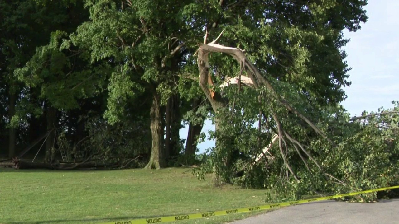
Powerful storms and heavy rain barreled through southeastern Wisconsin on Thursday morning, Sept. 3. Richfield, Washington County, was hard hit and crews were still working into the night as more storms were on the horizon.
Powerful storms and heavy rain barreled through southeastern Wisconsin on Thursday morning, Sept. 3. Richfield, Washington County, was hard hit and crews were still working into the night as more storms were on the horizon.
Milwaukee Weather: More storms, HOT and HUMID on Friday
Another chance for t-storms overnight. Any storms could produce flooding, lightning, strong winds, hail and an isolated tornado. Areas of fog developing near the lake. Very hot and humid on Friday. Highs in the low-to-mid 90s with a heat index of 100. Scattered t-storms are also possible as this stationary front lingers across the area. Again, HOT and HUMID on Friday. The front moves south on Saturday, cooling us down AND dropping our dew points into the 60s. Only a slight chance for a t-storm on Saturday. Greater chances for storms on Sunday night. Highs in the 70s/80s.
Another chance for t-storms overnight. Any storms could produce flooding, lightning, strong winds, hail and an isolated tornado. Areas of fog developing near the lake. Very hot and humid on Friday. Highs in the low-to-mid 90s with a heat index of 100. Scattered t-storms are also possible as this stationary front lingers across the area. Again, HOT and HUMID on Friday. The front moves south on Saturday, cooling us down AND dropping our dew points into the 60s. Only a slight chance for a t-storm on Saturday. Greater chances for storms on Sunday night. Highs in the 70s/80s.
Milwaukee weather: More storms tonight, hot on Friday
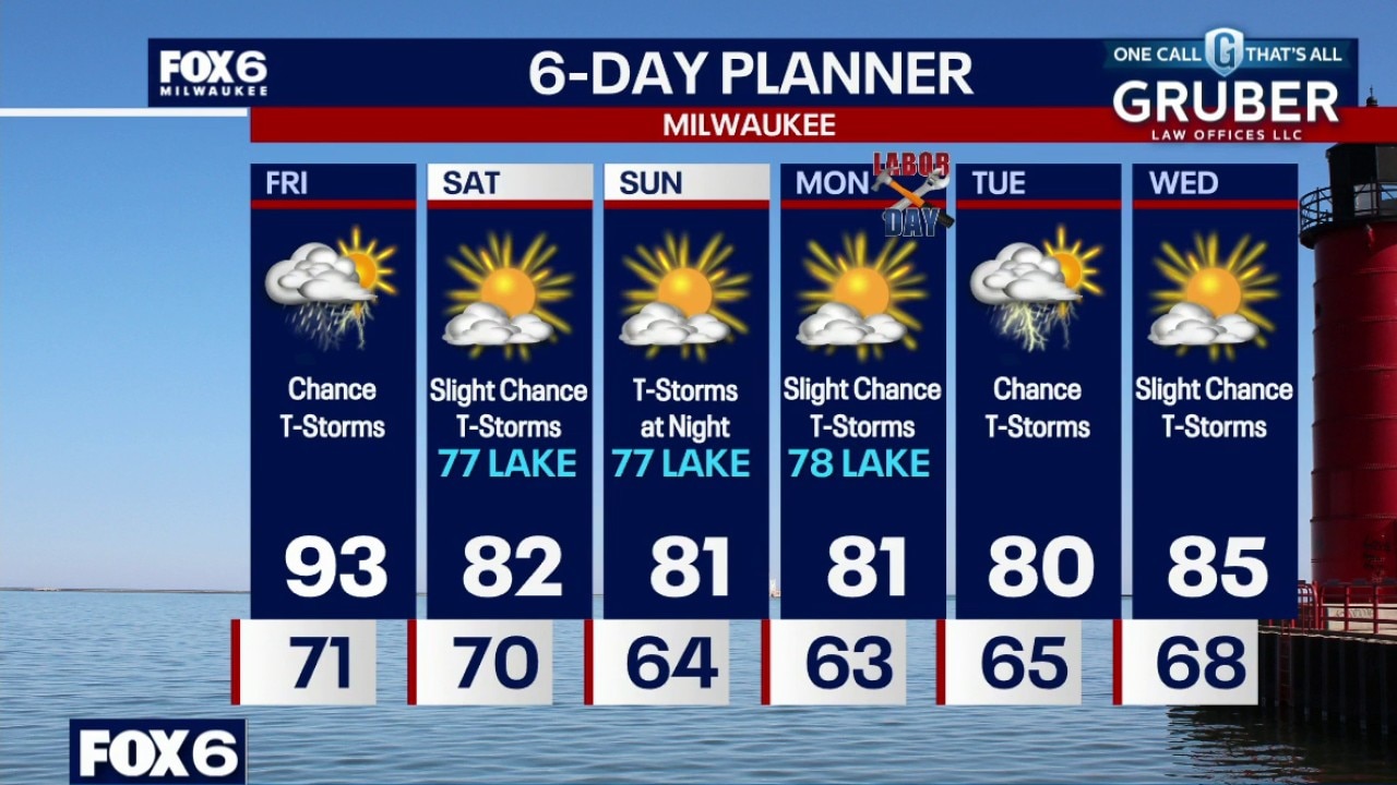
Another chance for t-storms tonight, especially late this evening and overnight. Any storms could produce flooding, strong winds, hail and an isolated tornado. Areas of fog developing near the lake. Very hot and humid on Friday. Highs in the low-to-mid 90s with a heat index of 100. Scattered t-storms are also possible as this stationary front lingers across the area. Again, HOT and HUMID on Friday.
Another chance for t-storms tonight, especially late this evening and overnight. Any storms could produce flooding, strong winds, hail and an isolated tornado. Areas of fog developing near the lake. Very hot and humid on Friday. Highs in the low-to-mid 90s with a heat index of 100. Scattered t-storms are also possible as this stationary front lingers across the area. Again, HOT and HUMID on Friday.
Milwaukee weather: Hot and humid with storms
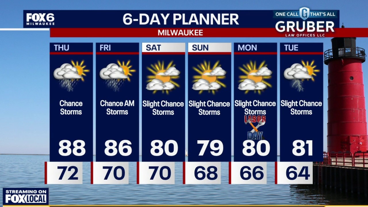
Showers and storms likely on Thursday, especially the evening. Highs in the mid-to-upper 80s and a heat index in the 90s.
Showers and storms likely on Thursday, especially the evening. Highs in the mid-to-upper 80s and a heat index in the 90s.
Wisconsin weather Thursday; afternoon, evening storms possible
The FOX6 Weather Experts say showers and storms are likely on Thursday, especially in the evening. Highs in the mid-to-upper 80s and a heat index in the 90s. Follow live updates below.
The FOX6 Weather Experts say showers and storms are likely on Thursday, especially in the evening. Highs in the mid-to-upper 80s and a heat index in the 90s. Follow live updates below.
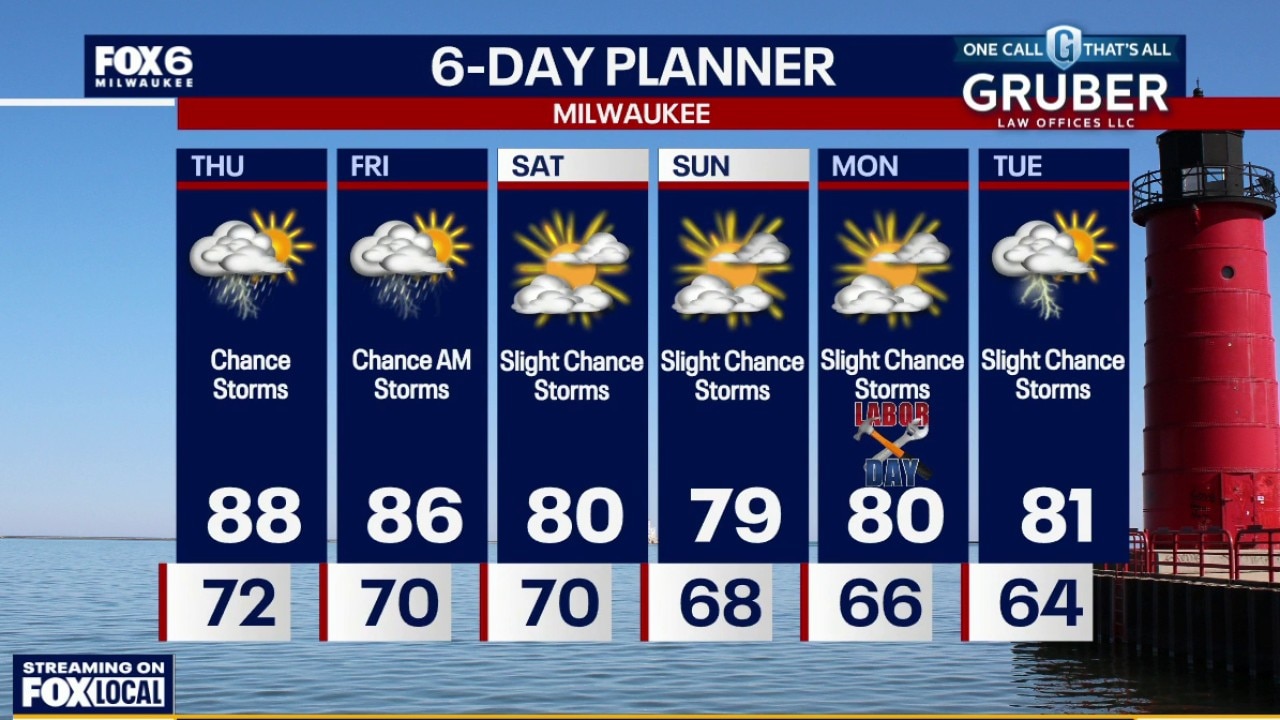
Milwaukee weather: Hot and humid with storms today
Areas of patchy to dense fog Thursday morning. Warm and very humid. Showers and storms likely on Thursday, especially the evening. Highs in the mid-to-upper 80s and a heat index in the 90s.
Areas of patchy to dense fog Thursday morning. Warm and very humid. Showers and storms likely on Thursday, especially the evening. Highs in the mid-to-upper 80s and a heat index in the 90s.
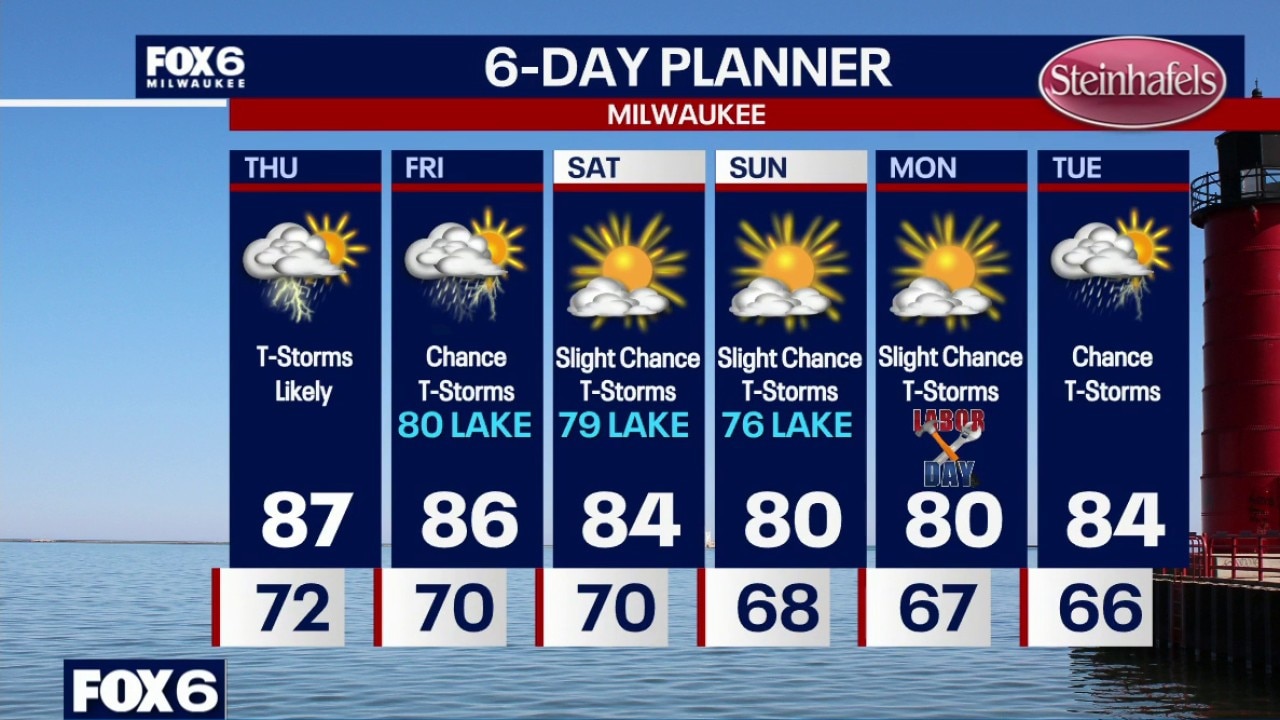
Milwaukee weather: T-Storm chances increasing
Very humid overnight with a slight chance for a t-storm. Temperatures will hold in the 70s. Areas of dense fog possible near the lakeshore. Showers and t-storms likely on Thursday with highs in the mid-to-upper 80s and a heat index in the low-90s. Cooling near the lake in the afternoon. This weather pattern continues on Friday with highs in the 80s, chances for t-storms and dew points around 70.
Very humid overnight with a slight chance for a t-storm. Temperatures will hold in the 70s. Areas of dense fog possible near the lakeshore. Showers and t-storms likely on Thursday with highs in the mid-to-upper 80s and a heat index in the low-90s. Cooling near the lake in the afternoon. This weather pattern continues on Friday with highs in the 80s, chances for t-storms and dew points around 70.
Milwaukee Weather: High humidity levels continue
Very humid overnight with a slight chance for a t-storm. Temperatures will hold in the 70s. Areas of dense fog possible near the lakeshore. Showers and t-storms likely on Thursday with highs in the mid-to-upper 80s and a heat index in the low-90s. Cooling near the lake in the afternoon. This weather pattern continues on Friday with highs in the 80s, chances for t-storms and dew points around 70.
Very humid overnight with a slight chance for a t-storm. Temperatures will hold in the 70s. Areas of dense fog possible near the lakeshore. Showers and t-storms likely on Thursday with highs in the mid-to-upper 80s and a heat index in the low-90s. Cooling near the lake in the afternoon. This weather pattern continues on Friday with highs in the 80s, chances for t-storms and dew points around 70.
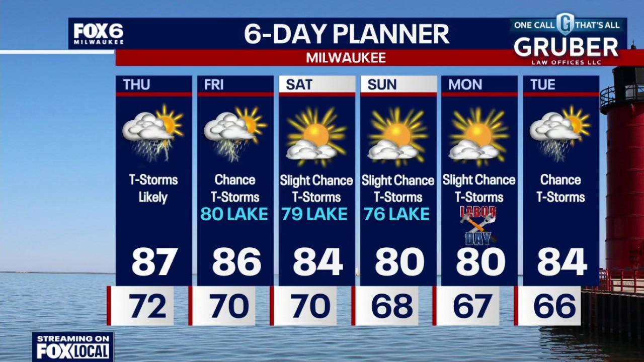
Milwaukee weather: High humidity levels continue
Very humid tonight with a slight chance for a t-storm or two. Temperatures will hold in the 70s overnight. Areas of dense fog possible near the lakeshore. Showers and t-storms likely on Thursday with highs in the mid-to-upper 80s and a heat index in the low-90s. Cooling near the lake in the afternoon. This weather pattern continues on Friday with highs in the 80s, chances for t-storms and dew points around 70.
Very humid tonight with a slight chance for a t-storm or two. Temperatures will hold in the 70s overnight. Areas of dense fog possible near the lakeshore. Showers and t-storms likely on Thursday with highs in the mid-to-upper 80s and a heat index in the low-90s. Cooling near the lake in the afternoon. This weather pattern continues on Friday with highs in the 80s, chances for t-storms and dew points around 70.
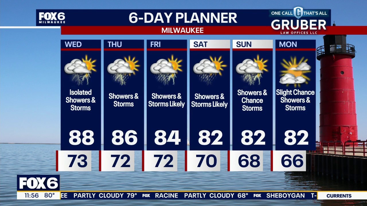
Milwaukee weather: Hot, humid and still stormy
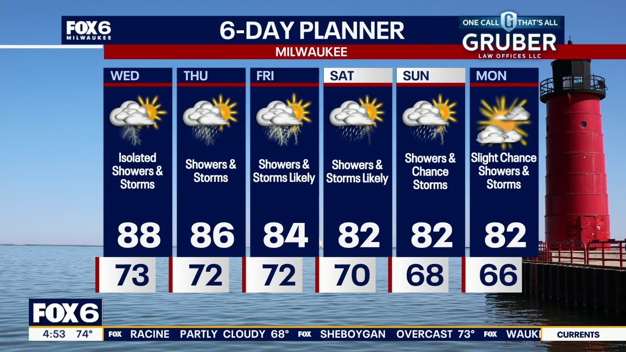
Hot, humid and occasionally stormy weather remains the theme Wednesday and through the rest of the workweek. Thursday night into Friday morning may be the period to watch most closely, as a disturbance could bring a better-organized round of thunderstorms if the ingredients line up.
Hot, humid and occasionally stormy weather remains the theme Wednesday and through the rest of the workweek. Thursday night into Friday morning may be the period to watch most closely, as a disturbance could bring a better-organized round of thunderstorms if the ingredients line up.
Milwaukee weather: Hot, humid and occasionally stormy
Hot, humid and occasionally stormy weather remains the theme Wednesday and through the rest of the workweek. Thursday night into Friday morning may be the period to watch most closely, as a disturbance could bring a better-organized round of thunderstorms if the ingredients line up.
Hot, humid and occasionally stormy weather remains the theme Wednesday and through the rest of the workweek. Thursday night into Friday morning may be the period to watch most closely, as a disturbance could bring a better-organized round of thunderstorms if the ingredients line up.
Milwaukee weather: Extreme humidity continues
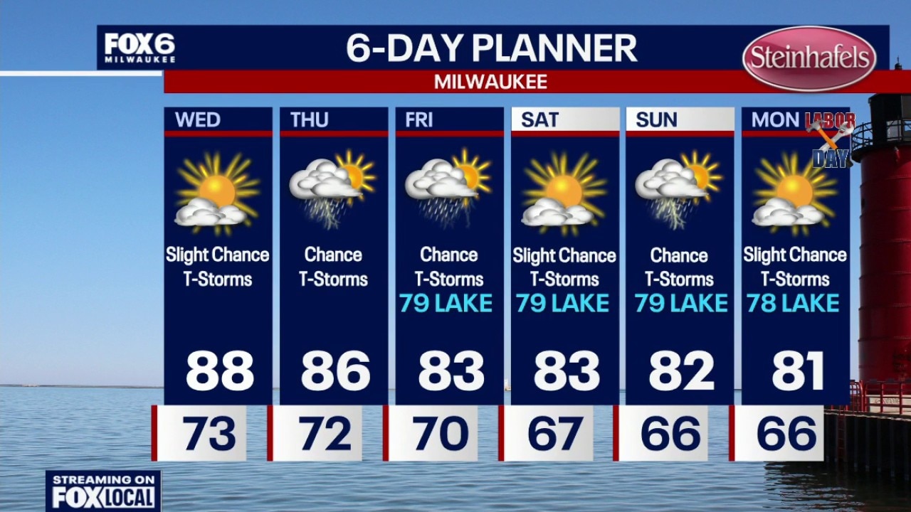
Extremely humid tonight with a chance for t-storms. A complex of t-storms could impact parts of the area by morning (mainly northern areas). Temperatures will be in the 70s overnight. Partly sunny, hot and humid on Wednesday with a slight chance for t-storms. Highs in the upper 80s with dew points in the low 70s. A few degrees cooler near the lake in the afternoon. The heat index will be around 95.
Extremely humid tonight with a chance for t-storms. A complex of t-storms could impact parts of the area by morning (mainly northern areas). Temperatures will be in the 70s overnight. Partly sunny, hot and humid on Wednesday with a slight chance for t-storms. Highs in the upper 80s with dew points in the low 70s. A few degrees cooler near the lake in the afternoon. The heat index will be around 95.