


Weather Webcast with Chief Meteorologist Tom Wachs
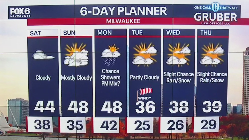
Mostly cloudy and windy tonight with temperatures in the 30s. The cool air filters in overnight as skies clear out with sunrise temperatures in the 20s. Windy, cool and mostly sunny on Tuesday. Highs in the mid-30s.
Mostly cloudy and windy tonight with temperatures in the 30s. The cool air filters in overnight as skies clear out with sunrise temperatures in the 20s. Windy, cool and mostly sunny on Tuesday. Highs in the mid-30s.
Weather Webcast with Stephanie Barichello
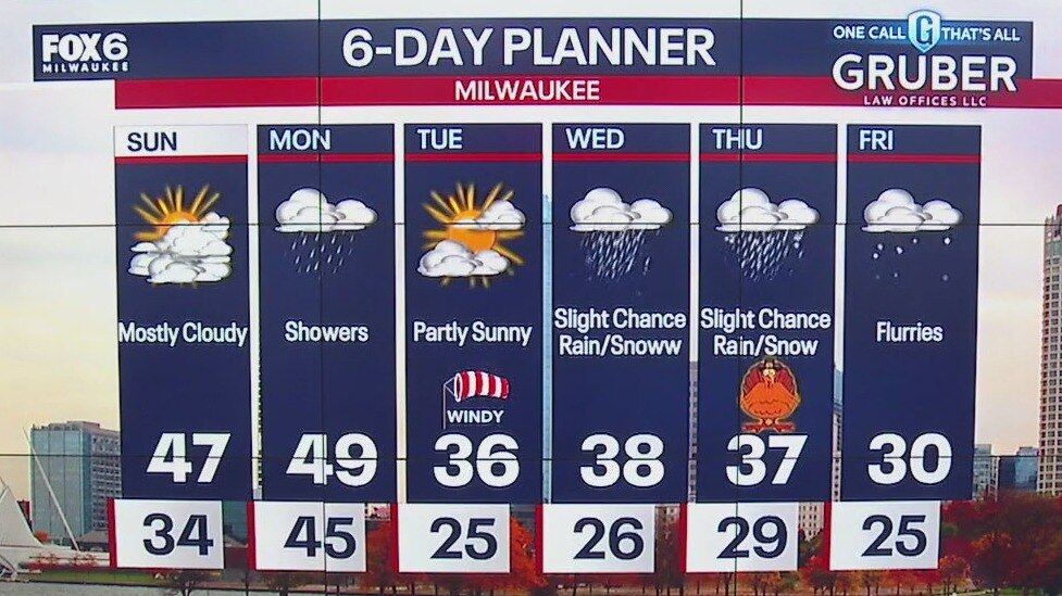
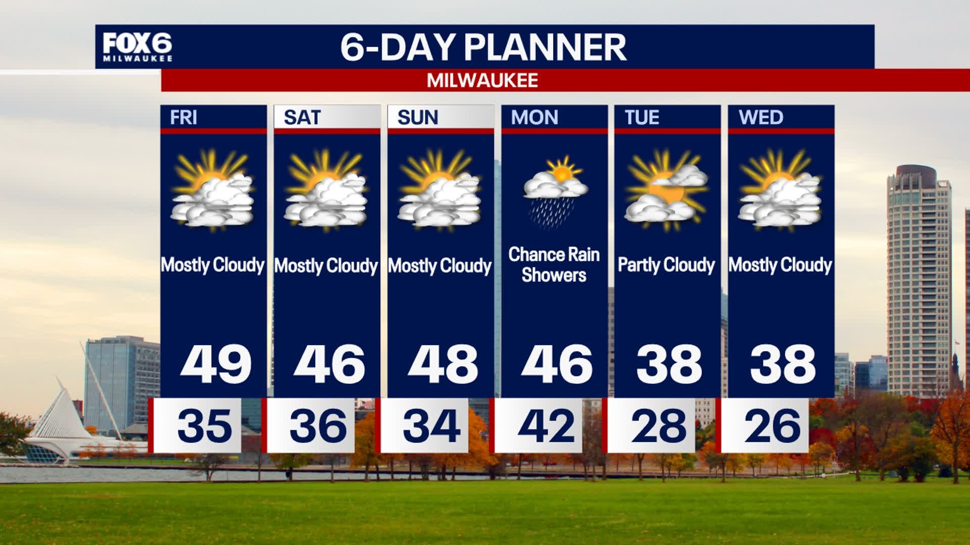
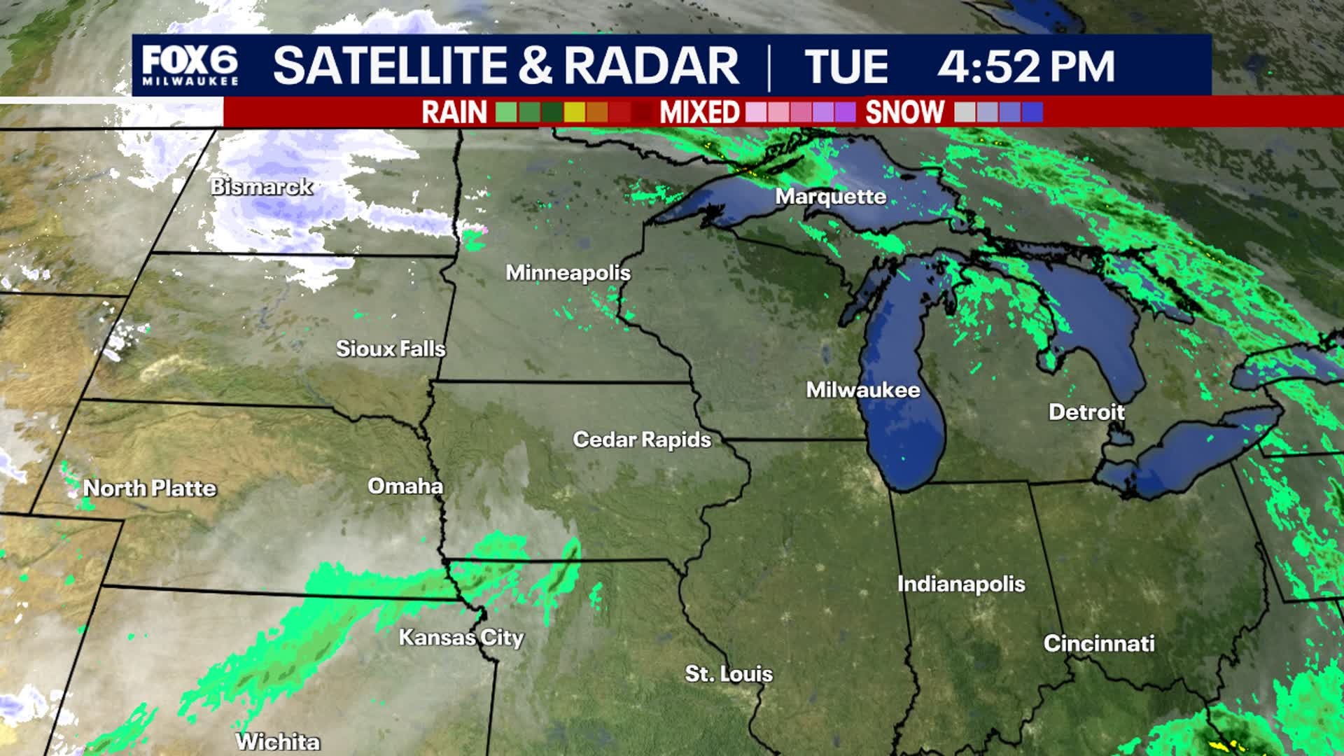
Rain showers will move through this afternoon with some evening wintry mix or light snow, then clearing overnight. It'll be much colder Tuesday morning with lows in the 20s and wind chills in the teens, then we'll only climb into the middle 30s. There is a slight chance for rain/snow on Wednesday, although the better chance is south of us in IL. Dry but cold for Thanksgiving then a push of even colder air to end the week and start the weekend.
Rain showers will move through this afternoon with some evening wintry mix or light snow, then clearing overnight. It'll be much colder Tuesday morning with lows in the 20s and wind chills in the teens, then we'll only climb into the middle 30s. There is a slight chance for rain/snow on Wednesday, although the better chance is south of us in IL. Dry but cold for Thanksgiving then a push of even colder air to end the week and start the weekend.
Weather webcast with Lisa Michaels
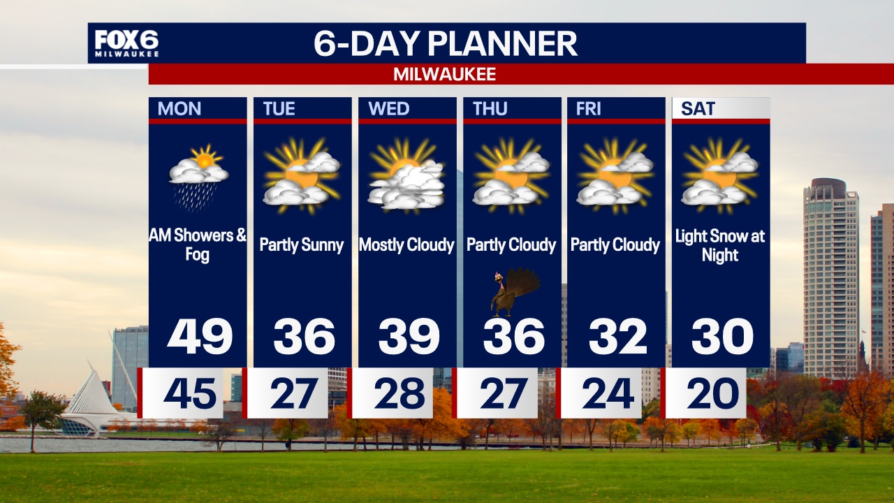
Light fog Monday morning. Cloudy Monday with scattered rain showers. A few snowflakes can mix in during the afternoon. Highs in the mid to upper 40s. A cold front will move through this afternoon dropping temperatures into the 20s by Monday night. Wind chills will be in the single digits/teens by Tuesday morning. The coldest air of the season arrives this week with the first round on Monday night into Tuesday. An even colder air mass by Friday and the holiday weekend. There are slight chances for rain/snow showers on Wednesday. Little to no impacts expected.
Light fog Monday morning. Cloudy Monday with scattered rain showers. A few snowflakes can mix in during the afternoon. Highs in the mid to upper 40s. A cold front will move through this afternoon dropping temperatures into the 20s by Monday night. Wind chills will be in the single digits/teens by Tuesday morning. The coldest air of the season arrives this week with the first round on Monday night into Tuesday. An even colder air mass by Friday and the holiday weekend. There are slight chances for rain/snow showers on Wednesday. Little to no impacts expected.

Weather Webcast with Chief Meteorologist Tom Wachs
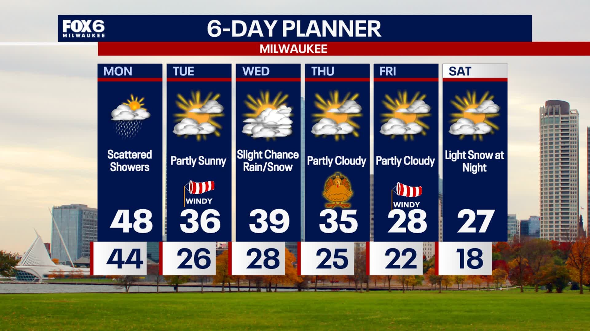
Scattered rain showers overnight with patchy fog. Temperatures in the 40s. Scattered rain showers on Monday with highs in the upper 40s. Much colder on Tuesday with highs in the 30s.
Scattered rain showers overnight with patchy fog. Temperatures in the 40s. Scattered rain showers on Monday with highs in the upper 40s. Much colder on Tuesday with highs in the 30s.
Weather Webcast with Chief Meteorologist Tom Wachs
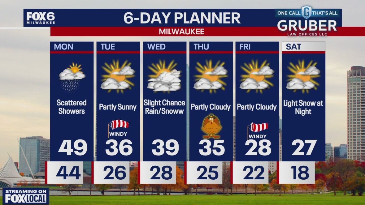
Light rain showers will develop this evening and continue through Monday morning along with some fog. Steady temperatures in the 40s all night. Morning rain showers/fog on Monday with cloudy skies and an afternoon high in the upper 40s.
Light rain showers will develop this evening and continue through Monday morning along with some fog. Steady temperatures in the 40s all night. Morning rain showers/fog on Monday with cloudy skies and an afternoon high in the upper 40s.
Weather webcast with Lisa Michaels
Light fog Sunday morning. Mostly cloudy skies today with high temps a few degrees warmer in the mid to upper 40s. A low pressure system slides just south of the Wisconsin-Illinois border tonight.
Light fog Sunday morning. Mostly cloudy skies today with high temps a few degrees warmer in the mid to upper 40s. A low pressure system slides just south of the Wisconsin-Illinois border tonight.

Weather Webcast with Holly Baker
Skies remain cloudy with near normal temps.
Skies remain cloudy with near normal temps.
Weather webcast with Lisa Michaels
Cloudy skies take over Saturday with seasonable high temperatures in the mid-40s. A few peeks of sunshine back on Sunday under mostly cloudy skies with high temps a few degrees warmer in the upper 40s.
Cloudy skies take over Saturday with seasonable high temperatures in the mid-40s. A few peeks of sunshine back on Sunday under mostly cloudy skies with high temps a few degrees warmer in the upper 40s.

Weather Webcast with Holly Baker
Conditions remain dry throughout the weekend.
Conditions remain dry throughout the weekend.
Weather Webcast with Stephanie Barichello
Mostly cloudy today and windy with temperatures in the 40s. Quiet over the weekend with potential sunshine Saturday afternoon. Next chance for rain arrives Monday, which may mix with snow in the evening. Much colder the rest of the week with highs in the 30s and lows in the 20s.
Mostly cloudy today and windy with temperatures in the 40s. Quiet over the weekend with potential sunshine Saturday afternoon. Next chance for rain arrives Monday, which may mix with snow in the evening. Much colder the rest of the week with highs in the 30s and lows in the 20s.
Weather webcast with Rob Haswell
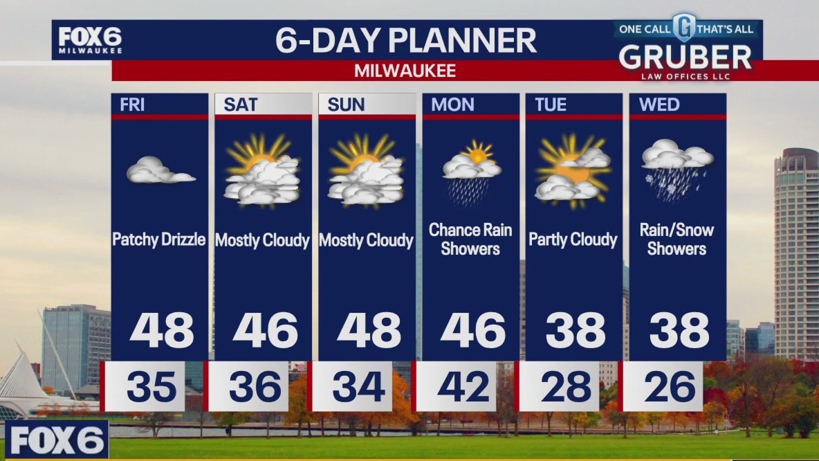
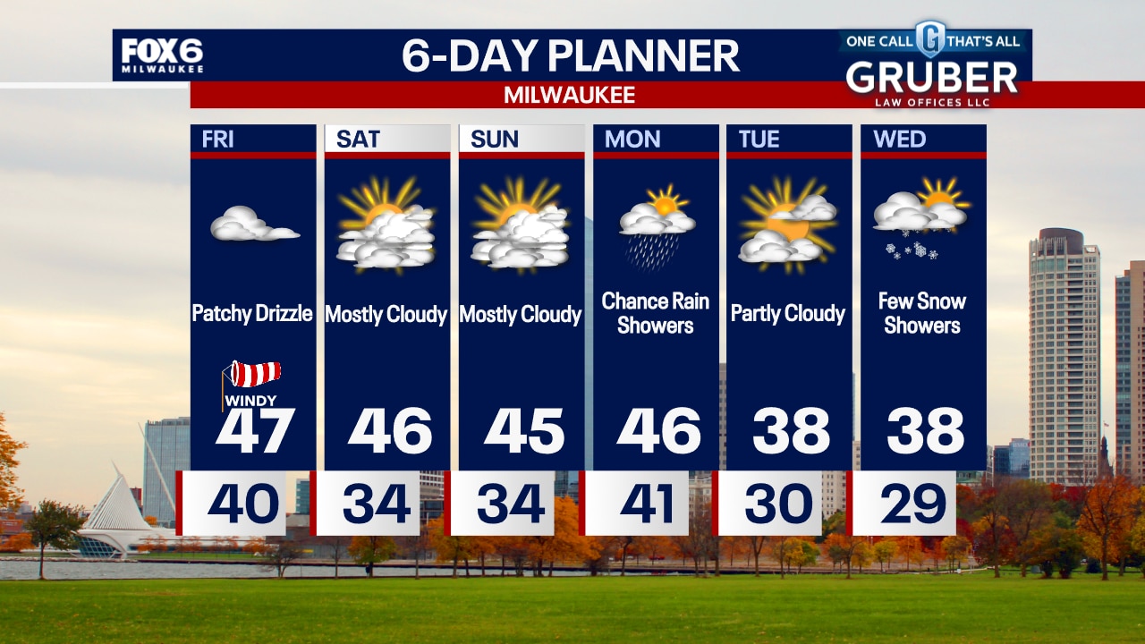
Some patchy drizzle this morning then mostly cloudy and milder today with highs in the mid to upper 40s. We should stay dry from this afternoon through Sunday afternoon with rain showers returning Sunday night into Monday. We will be mild from today through Monday but cooler air arrives by mid next week. Our next chance for accumulating snow comes Thanksgiving weekend.
Some patchy drizzle this morning then mostly cloudy and milder today with highs in the mid to upper 40s. We should stay dry from this afternoon through Sunday afternoon with rain showers returning Sunday night into Monday. We will be mild from today through Monday but cooler air arrives by mid next week. Our next chance for accumulating snow comes Thanksgiving weekend.

Weather Webcast with Chief Meteorologist Tom Wachs
Light rain will taper off overnight with temperatures staying above freezing. Cloudy with patchy drizzle on Friday along with highs in the mid-40s and gusty northwest winds.
Light rain will taper off overnight with temperatures staying above freezing. Cloudy with patchy drizzle on Friday along with highs in the mid-40s and gusty northwest winds.
Weather Webcast with Chief Meteorologist Tom Wachs
Rain showers tapering off this evening with temperatures hovering around 40 all night. Cloudy with patchy drizzle on Friday with highs in the mid-to-upper 40s.
Rain showers tapering off this evening with temperatures hovering around 40 all night. Cloudy with patchy drizzle on Friday with highs in the mid-to-upper 40s.

Weather webcast with Rob Haswell
Wet snow this morning through the noon hour with a Winter Weather Advisory from 6am until Noon. Up to 3" of wet snow is possible in some areas before changing to rain later today. A Wind Advisory is in effect with wind gusts in excess of 40 mph at times. Take care on area roads. We calm overnight and warm up to the mid to upper 40s Friday and into the weekend.
Wet snow this morning through the noon hour with a Winter Weather Advisory from 6am until Noon. Up to 3" of wet snow is possible in some areas before changing to rain later today. A Wind Advisory is in effect with wind gusts in excess of 40 mph at times. Take care on area roads. We calm overnight and warm up to the mid to upper 40s Friday and into the weekend.
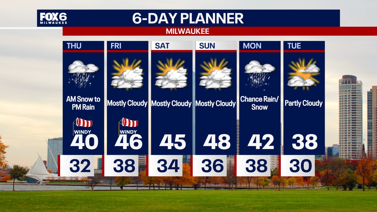
Weather Webcast with Chief Meteorologist Tom Wachs
Winter Weather Advisory on Thursday morning. Very windy and snowy with 1-2" of snow near the lake, 2-4" inland from 6am-Noon. Snow will change to rain in the afternoon. Very slow travel expected in the morning.
Winter Weather Advisory on Thursday morning. Very windy and snowy with 1-2" of snow near the lake, 2-4" inland from 6am-Noon. Snow will change to rain in the afternoon. Very slow travel expected in the morning.
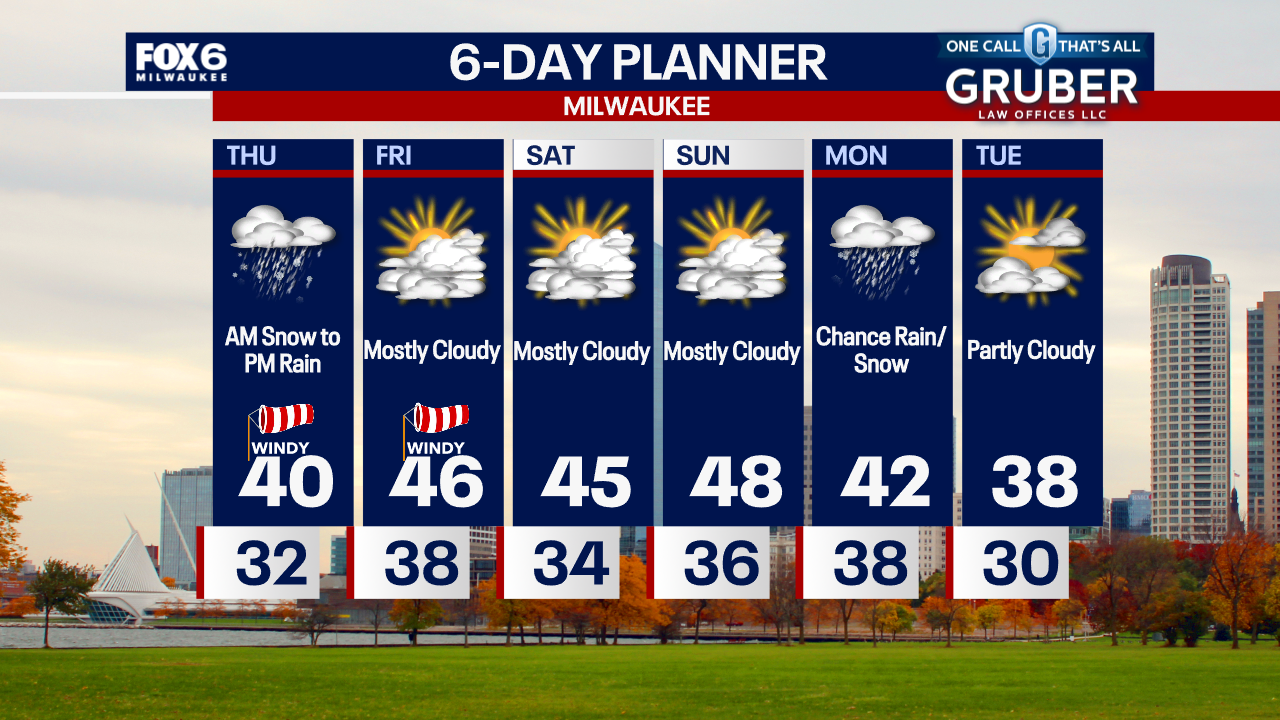
Weather Webcast with Chief Meteorologist Tom Wachs
Snow showers and a few rain showers continue near the lake tonight, but it will get lighter as the night goes on. A Winter Weather Advisory is in effect Thursday morning. 1-2" of snow near the lake, 2-4" inland. Slow AM commute before changing to rain the afternoon.
Snow showers and a few rain showers continue near the lake tonight, but it will get lighter as the night goes on. A Winter Weather Advisory is in effect Thursday morning. 1-2" of snow near the lake, 2-4" inland. Slow AM commute before changing to rain the afternoon.
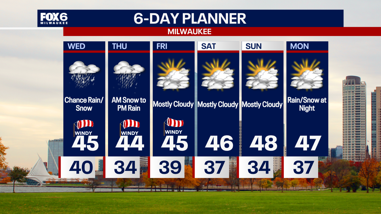
Weather webcast with Stephanie Barichello
Mostly cloudy this afternoon with scattered snow showers, possible rain/snow mix at times. It'll be breezy and cooler in the middle 40s.
Mostly cloudy this afternoon with scattered snow showers, possible rain/snow mix at times. It'll be breezy and cooler in the middle 40s.

Weather webcast with Rob Haswell
A few showers to start our day with mild temperatures still in place but cooler air will cause precipitation to change over to snow later today and tonight. Temperatures remain in the low to mid 40s through noon but fall later today and should get below freezing everywhere overnight. Another round of snow is likely overnight into early Thursday with an inch or two of wet snow possible. A Winter Weather Advisory goes into effect Thursday at 6am. We dry up for the weekend with seasonal temperatures.
A few showers to start our day with mild temperatures still in place but cooler air will cause precipitation to change over to snow later today and tonight. Temperatures remain in the low to mid 40s through noon but fall later today and should get below freezing everywhere overnight. Another round of snow is likely overnight into early Thursday with an inch or two of wet snow possible. A Winter Weather Advisory goes into effect Thursday at 6am. We dry up for the weekend with seasonal temperatures.
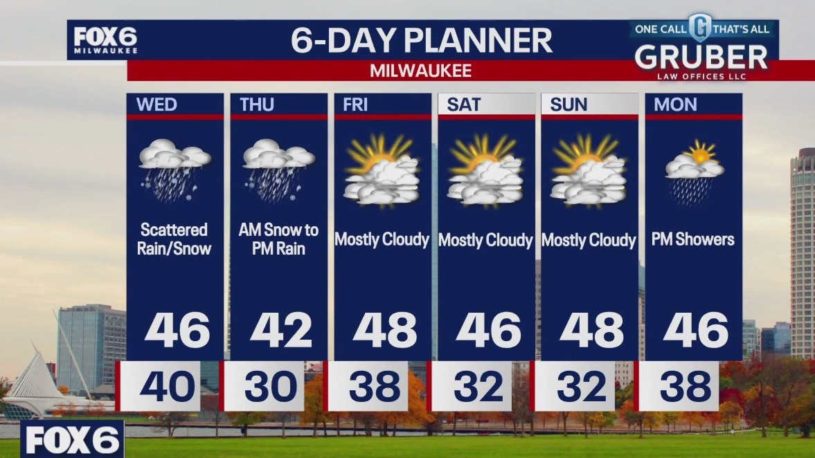
Weather Webcast with Chief Meteorologist Tom Wachs
A few light rain showers possible Wednesday morning with scattered snow showers (rain along the lake) on Wednesday afternoon. Blustery with highs in the 40s. Accumulating snow and very strong winds are likely on Thursday morning.
A few light rain showers possible Wednesday morning with scattered snow showers (rain along the lake) on Wednesday afternoon. Blustery with highs in the 40s. Accumulating snow and very strong winds are likely on Thursday morning.
Weather Webcast with Chief Meteorologist Tom Wachs
Quiet tonight with temperatures falling through the 40s. Scattered afternoon snow and rain showers. Highs in the 40s. Accumulating snow is likely on Thursday morning along with 40mph winds out of the northwest. Slow travel is expected.
Quiet tonight with temperatures falling through the 40s. Scattered afternoon snow and rain showers. Highs in the 40s. Accumulating snow is likely on Thursday morning along with 40mph winds out of the northwest. Slow travel is expected.