

Weather webcast with Lisa Michaels
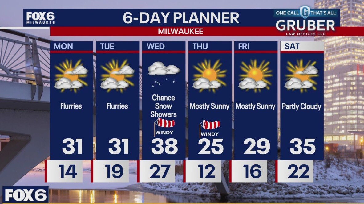
Chance for a few flurries Monday morning. Cool with wind chills in the single digits and low teens. Partly cloudy skies on Monday with highs slightly warmer in the low 30s. Wind chills remain in the 20s during the day. A gradual warming trend will bring temperatures back into the 30s through the first half of the week with flurries chances Monday and Tuesday. Light snow showers possible Wednesday. Another burst of cold arctic air returns by the end of the week with highs back in the 20s and wind chills in the single digits.
Chance for a few flurries Monday morning. Cool with wind chills in the single digits and low teens. Partly cloudy skies on Monday with highs slightly warmer in the low 30s. Wind chills remain in the 20s during the day. A gradual warming trend will bring temperatures back into the 30s through the first half of the week with flurries chances Monday and Tuesday. Light snow showers possible Wednesday. Another burst of cold arctic air returns by the end of the week with highs back in the 20s and wind chills in the single digits.
Weather Webcast with Chief Meteorologist Tom Wachs
Partly cloudy & cold overnight with wind chills around 0. Partly sunny and blustery on Monday with afternoon wind chills between +15 and +20.
Partly cloudy & cold overnight with wind chills around 0. Partly sunny and blustery on Monday with afternoon wind chills between +15 and +20.

Weather Webcast with Chief Meteorologist Tom Wachs
Mostly clear and cold tonight. Air temperatures in the teens and wind chills in the single digits. Partly sunny and blustery on Monday with a high around 30 and afternoon wind chills around +15 to +20.
Mostly clear and cold tonight. Air temperatures in the teens and wind chills in the single digits. Partly sunny and blustery on Monday with a high around 30 and afternoon wind chills around +15 to +20.
Weather webcast with Lisa Michaels
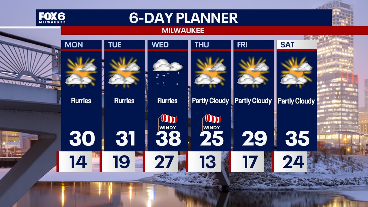
Mostly sunny day ahead with highs in the mid to upper 20s and wind chills in the teens. A gradual warming trend will bring temperatures back into the 30s through the first half of the week.
Mostly sunny day ahead with highs in the mid to upper 20s and wind chills in the teens. A gradual warming trend will bring temperatures back into the 30s through the first half of the week.

Weather Webcast with Chief Meteorologist Tom Wachs
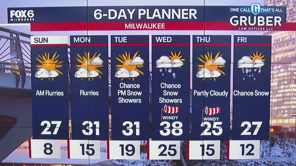
Clear and cold overnight with wind chills dipping below 0. Mostly sunny, blustery and chilly on Sunday with highs in the 20s and afternoon wind chills of +10 to +15.
Clear and cold overnight with wind chills dipping below 0. Mostly sunny, blustery and chilly on Sunday with highs in the 20s and afternoon wind chills of +10 to +15.
Weather Webcast with Chief Meteorologist Tom Wachs
Clear and cold tonight. Wind chills in the single digits this evening and below zero overnight. Mostly sunny and blustery on Sunday with afternoon wind chills between +10 and +15.
Clear and cold tonight. Wind chills in the single digits this evening and below zero overnight. Mostly sunny and blustery on Sunday with afternoon wind chills between +10 and +15.
Weather webcast with Lisa Michaels
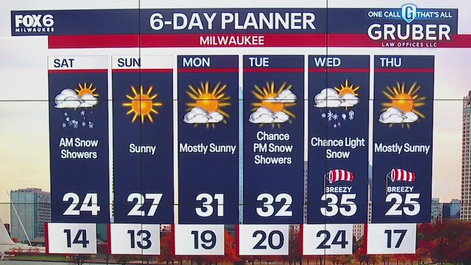
Morning snow showers and flurries across southeast Wisconsin Saturday morning. Skies transition to mostly sunny by the afternoon with highs in the low to mid 20s. Wind chills remain from 0? to 10? today.
Morning snow showers and flurries across southeast Wisconsin Saturday morning. Skies transition to mostly sunny by the afternoon with highs in the low to mid 20s. Wind chills remain from 0? to 10? today.
Weather Webcast with Stephanie Barichello
A few more flurries and light snow showers possible today then late day clearing. It'll be cold and windy with highs in the 20s and wind chills in the teens. The wind will stay strong through the weekend, and morning wind chills Saturday could be below 0 in spots. Sunshine through early next week then a chance for snow midweek.
A few more flurries and light snow showers possible today then late day clearing. It'll be cold and windy with highs in the 20s and wind chills in the teens. The wind will stay strong through the weekend, and morning wind chills Saturday could be below 0 in spots. Sunshine through early next week then a chance for snow midweek.
Weather webcast with Rob Haswell
A few flurries possible early this morning then clearing to mostly sunny but very cold. Highs today will be in the mid to upper 20s but feel like the teens with a strong WNW wind 10 - 20 mph.
A few flurries possible early this morning then clearing to mostly sunny but very cold. Highs today will be in the mid to upper 20s but feel like the teens with a strong WNW wind 10 - 20 mph.

Webcast Weather with Holly Baker
A few snow flurries linger overnight with cold temperatures expected for Black Friday.
A few snow flurries linger overnight with cold temperatures expected for Black Friday.
Weather webcast with Rob Haswell
Partly sunny and chilly again today with highs in the low 30s but feeling cooler with a strong NW breeze. A trough of low pressure swings through tonight for a chance of flurries but otherwise dry. Much colder air takes over this weekend and well into next week. Wind chills will at times be in the single digits during the day and sub-zero overnight. Our next chance for accumulating snow comes later next week.
Partly sunny and chilly again today with highs in the low 30s but feeling cooler with a strong NW breeze. A trough of low pressure swings through tonight for a chance of flurries but otherwise dry. Much colder air takes over this weekend and well into next week. Wind chills will at times be in the single digits during the day and sub-zero overnight. Our next chance for accumulating snow comes later next week.
Weather Webcast with Chief Meteorologist Tom Wachs
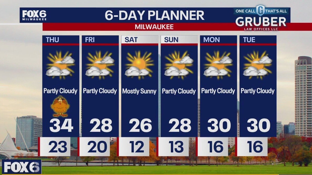
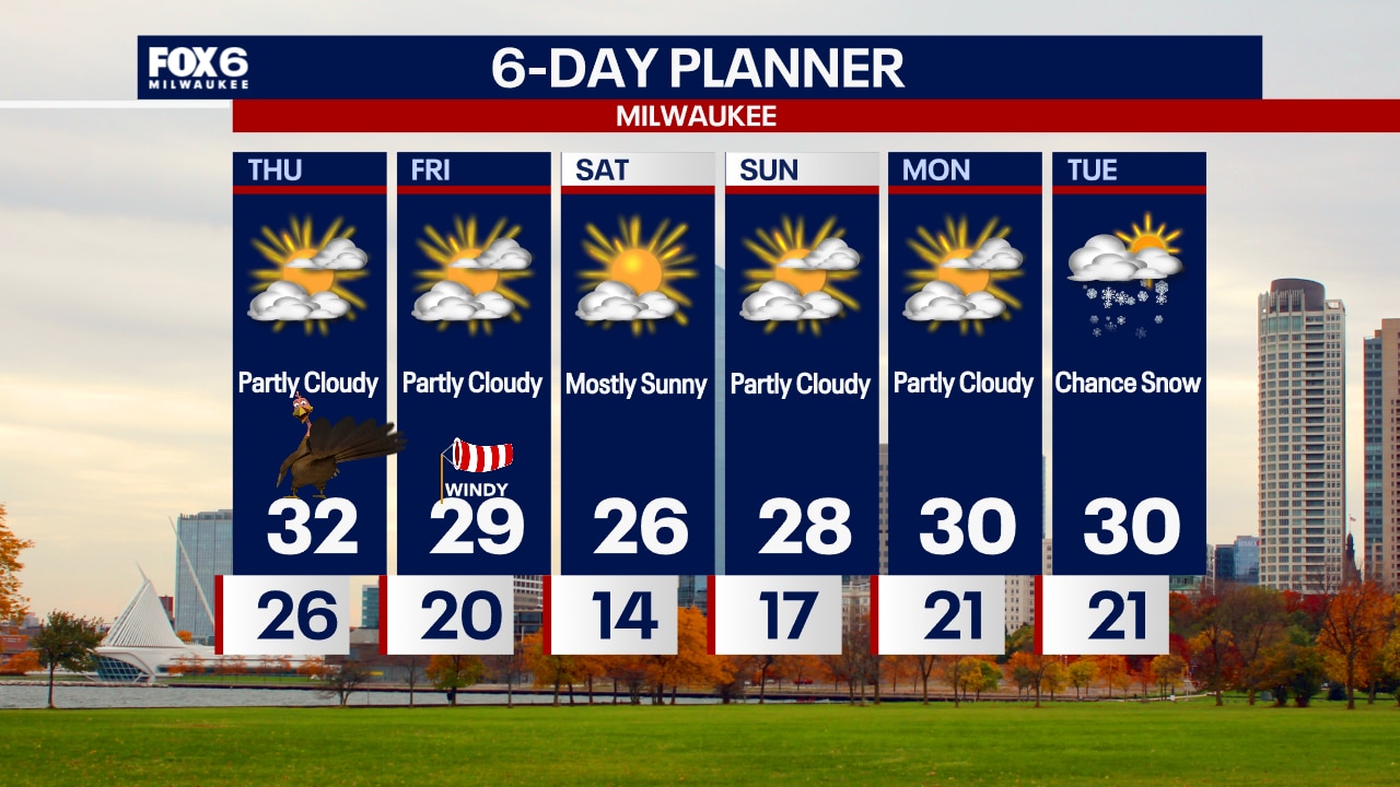
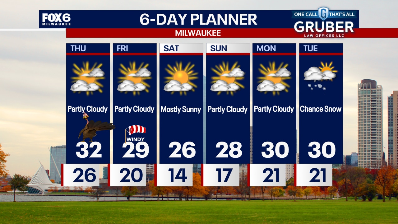
Partly to mostly cloudy on Thanksgiving, blustery with highs in the low 30s. Afternoon wind chills in the 20s. Even colder on Friday with a windy high in the 20s.
Partly to mostly cloudy on Thanksgiving, blustery with highs in the low 30s. Afternoon wind chills in the 20s. Even colder on Friday with a windy high in the 20s.
Weather Webcast with Chief Meteorologist Tom Wachs
Partly to mostly cloudy and blustery tonight with temperatures dropping into the 20s. Partly to mostly cloudy and blustery again on Thanksgiving with a high in the low 30s and afternoon wind chills in the 20s.
Partly to mostly cloudy and blustery tonight with temperatures dropping into the 20s. Partly to mostly cloudy and blustery again on Thanksgiving with a high in the low 30s and afternoon wind chills in the 20s.

Weather Webcast with Stephanie Barichello
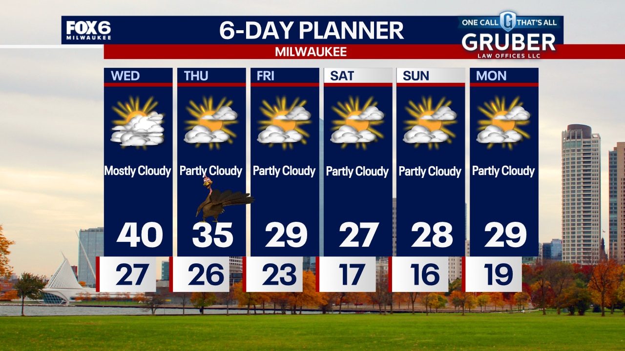
More clouds than sun today but overall quiet, with temperatures around 40. We drop into the 20s tonight, then spend Thanksgiving Day in the middle 30s. Much colder air spills in Friday and over the weekend with high temperatures in the 20s and lows in the teens. No major storm systems in sight.
More clouds than sun today but overall quiet, with temperatures around 40. We drop into the 20s tonight, then spend Thanksgiving Day in the middle 30s. Much colder air spills in Friday and over the weekend with high temperatures in the 20s and lows in the teens. No major storm systems in sight.
Weather webcast with Rob Haswell
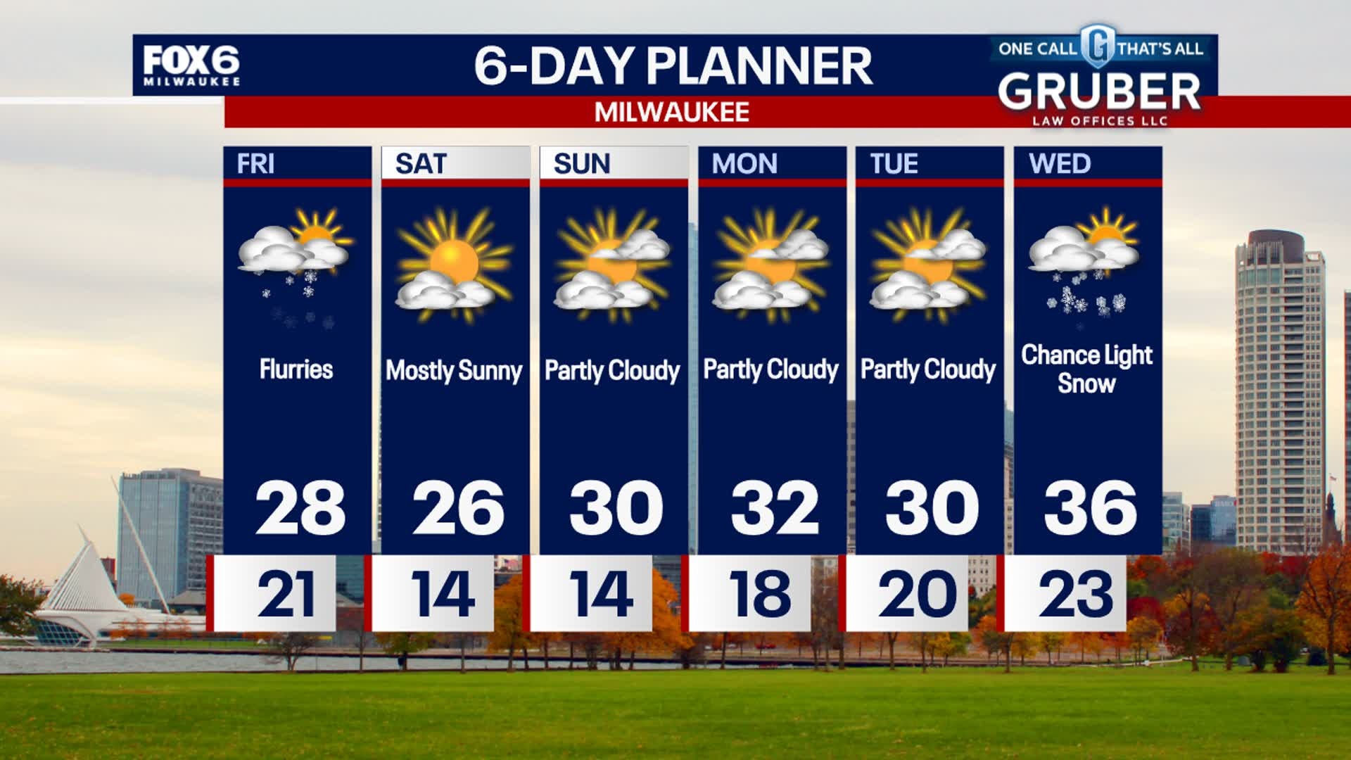
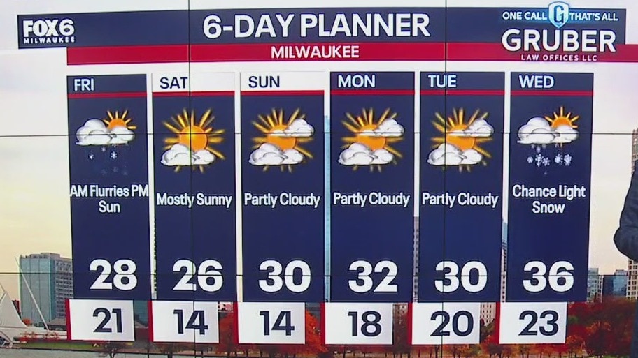
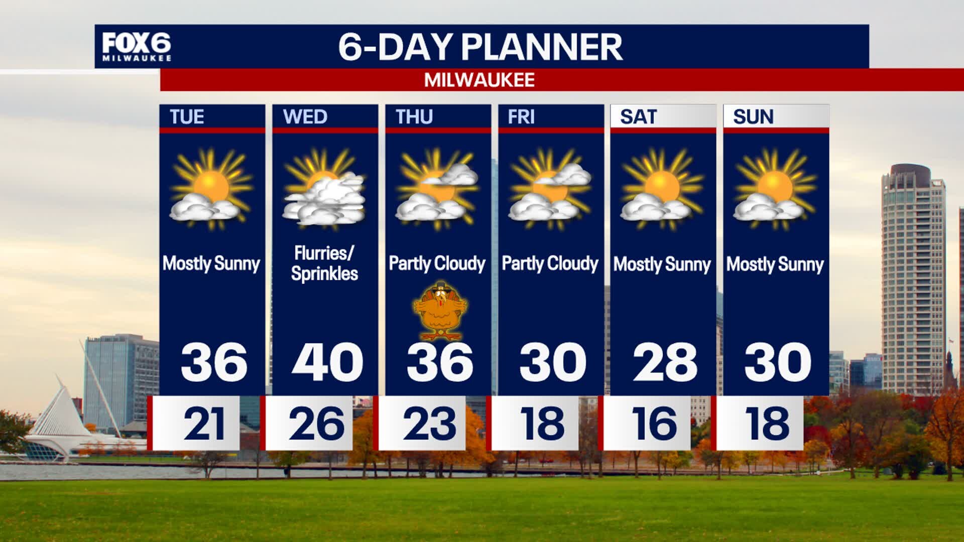
Another cooler than average day but not quite as cold at Tuesday. Highs will reach 40 in most areas. Thanksgiving will be cloudy with a slight chance for a few flurries and a bit cooler but the coldest air yet arrives Friday. Highs will fall into the 20s from Friday through Sunday with overnights in the teens and even lower inland. Other than a stray flurry we don't see any significant precipitation until later next week.
Another cooler than average day but not quite as cold at Tuesday. Highs will reach 40 in most areas. Thanksgiving will be cloudy with a slight chance for a few flurries and a bit cooler but the coldest air yet arrives Friday. Highs will fall into the 20s from Friday through Sunday with overnights in the teens and even lower inland. Other than a stray flurry we don't see any significant precipitation until later next week.
Weather Webcast with Chief Meteorologist Tom Wachs
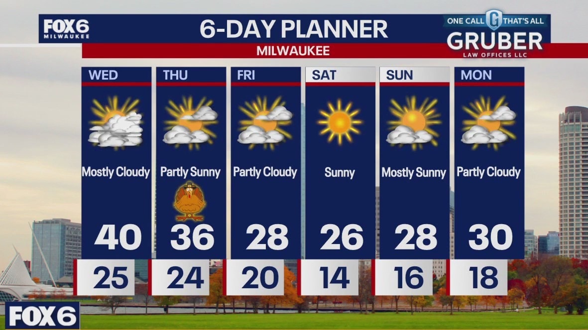
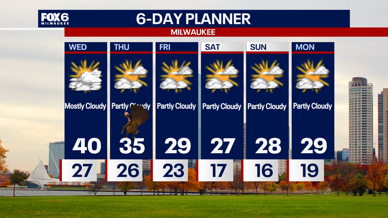
Increasing clouds overnight with temperatures in the 20s inland to around 30 near the lake. Partly to mostly cloudy on Wednesday with highs in the upper 30s to around 40. Blustery and chilly on Thanksgiving with highs in the mid-30s.
Increasing clouds overnight with temperatures in the 20s inland to around 30 near the lake. Partly to mostly cloudy on Wednesday with highs in the upper 30s to around 40. Blustery and chilly on Thanksgiving with highs in the mid-30s.
Weather Webcast with Chief Meteorologist Tom Wachs
Increasing clouds tonight with temperatures falling into the 20s. Partly to mostly cloudy skies on Wednesday with a high around 40. Partly sunny on Thanksgiving with a blustery high in the mid-30s.
Increasing clouds tonight with temperatures falling into the 20s. Partly to mostly cloudy skies on Wednesday with a high around 40. Partly sunny on Thanksgiving with a blustery high in the mid-30s.
Weather Webcast with Stephanie Barichello
Sunny today but chilly with temperatures in the 30s and wind chills in the 20s. More clouds Wednesday with a slight chance for flurries or sprinkles, mainly late in the day. Sunshine is back Thursday but temperatures will stay chilly. Even colder air moves in after Thanksgiving.
Sunny today but chilly with temperatures in the 30s and wind chills in the 20s. More clouds Wednesday with a slight chance for flurries or sprinkles, mainly late in the day. Sunshine is back Thursday but temperatures will stay chilly. Even colder air moves in after Thanksgiving.
Weather webcast with Rob Haswell
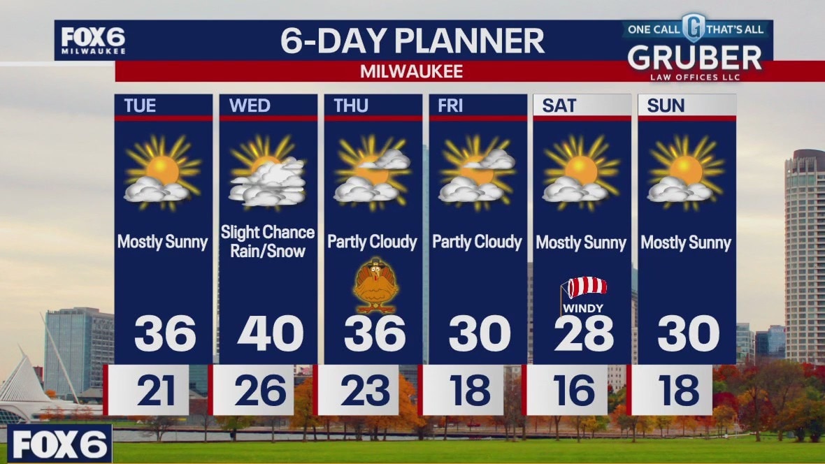
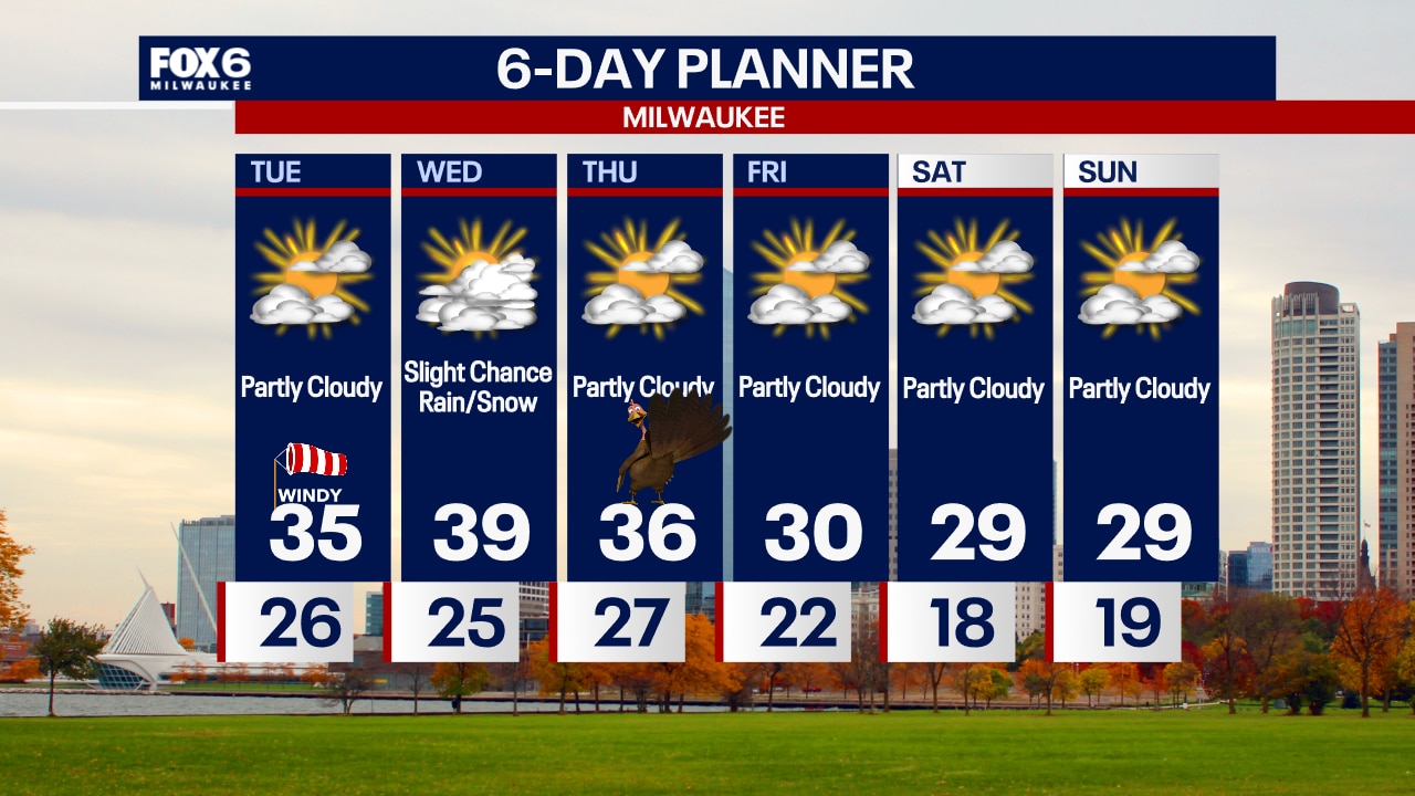
With high pressure in place we will have ample sunshine early but colder air is taking over and the next several days will be below average. Highs today will be in the mid to upper 30s and we'll fall into the 20s overnight. There is a slight chance for a few rain and snow showers on Wednesday but then we settle down of the holiday and into the weekend. Temperatures fall to the upper 20s by the weekend.
With high pressure in place we will have ample sunshine early but colder air is taking over and the next several days will be below average. Highs today will be in the mid to upper 30s and we'll fall into the 20s overnight. There is a slight chance for a few rain and snow showers on Wednesday but then we settle down of the holiday and into the weekend. Temperatures fall to the upper 20s by the weekend.
Weather Webcast with Chief Meteorologist Tom Wachs
Clearing skies overnight, windy and chilly. Temperatures in the 20s by sunrise. Mostly sunny on Tuesday with increasing afternoon clouds. Highs in the 30s with afternoon wind chills in the 20s.
Clearing skies overnight, windy and chilly. Temperatures in the 20s by sunrise. Mostly sunny on Tuesday with increasing afternoon clouds. Highs in the 30s with afternoon wind chills in the 20s.