

Weather Webcast with Chief Meteorologist Tom Wachs
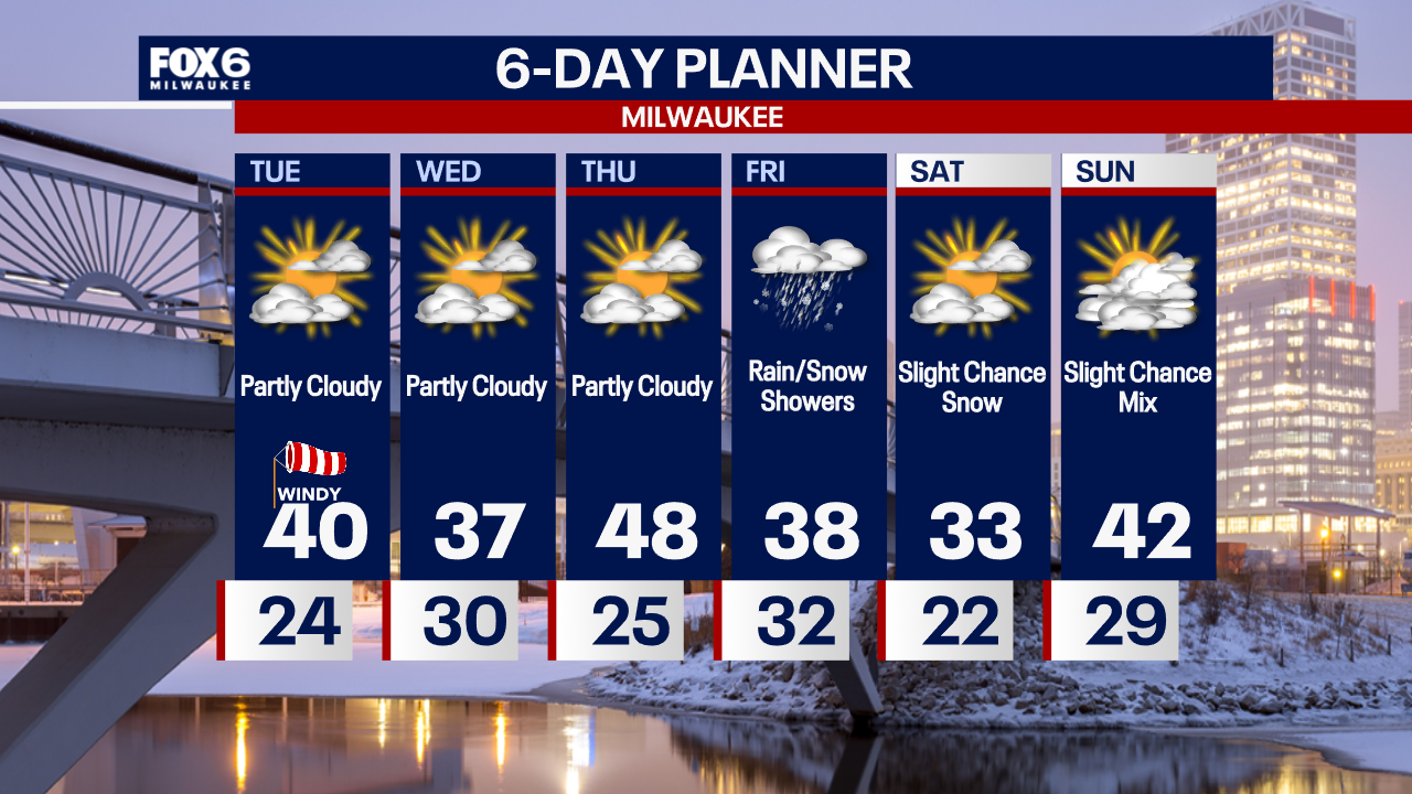
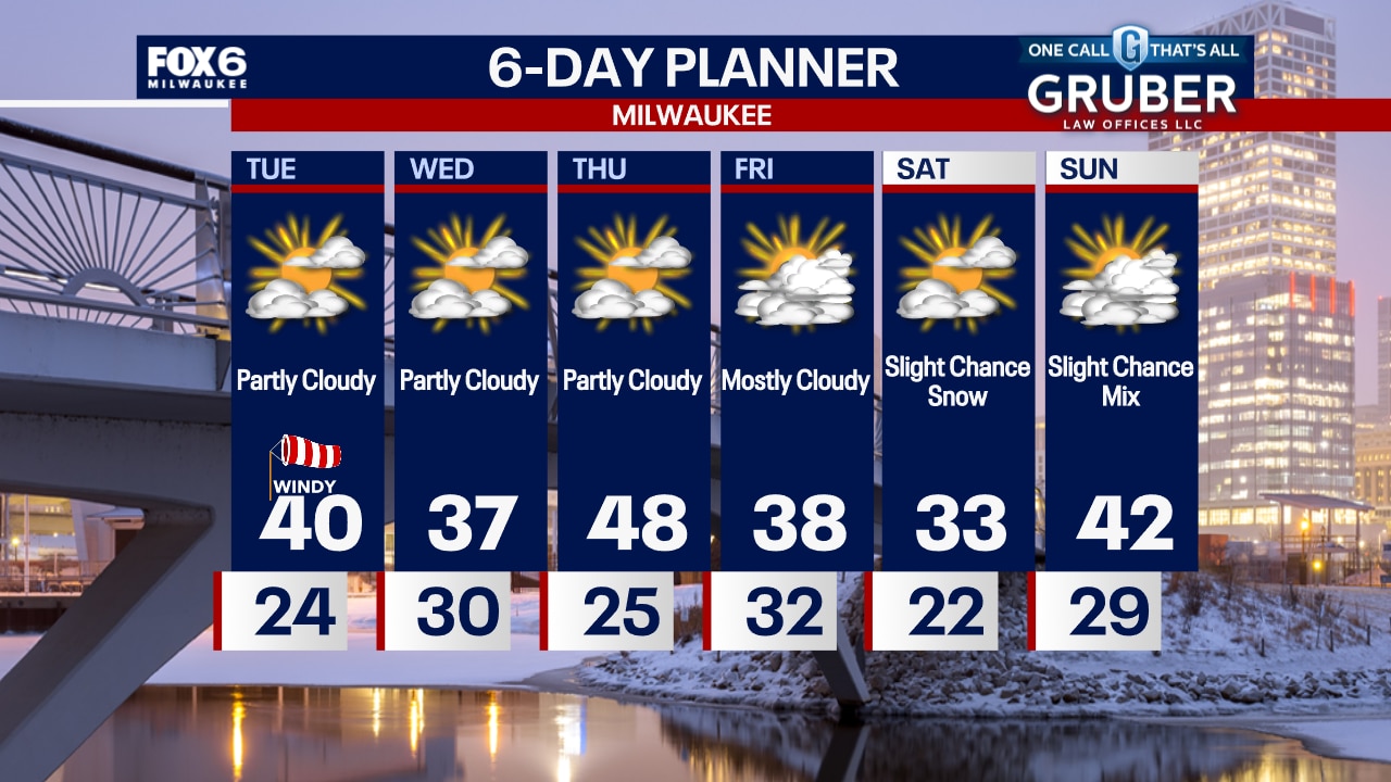
Partly cloudy and not as windy overnight. Temperatures dropping into the 20s. Increasing clouds on Tuesday with the wind picking back up. High temperatures around 40.
Partly cloudy and not as windy overnight. Temperatures dropping into the 20s. Increasing clouds on Tuesday with the wind picking back up. High temperatures around 40.
Weather Webcast with Chief Meteorologist Tom Wachs
The wind will settle down tonight before picking up again on Tuesday afternoon. Temperatures in the 20s overnight with highs around 40 on Tuesday.
The wind will settle down tonight before picking up again on Tuesday afternoon. Temperatures in the 20s overnight with highs around 40 on Tuesday.

Weather webcast with Lisa Michaels
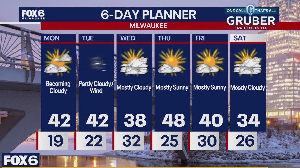
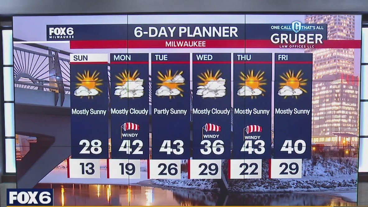
With a strong low passing to our north on this Monday, we expect significant wind gusts near 50 mph at times. The wind will be from the southwest helping us warm into the upper 30s and low 40s.
With a strong low passing to our north on this Monday, we expect significant wind gusts near 50 mph at times. The wind will be from the southwest helping us warm into the upper 30s and low 40s.
Weather webcast with Rob Haswell
With a strong low passing to our north on this Monday, we expect significant wind gusts near 50 mph at times. The wind will be from the southwest helping us warm into the upper 30s and low 40s.
With a strong low passing to our north on this Monday, we expect significant wind gusts near 50 mph at times. The wind will be from the southwest helping us warm into the upper 30s and low 40s.
Weather Webcast with Holly Baker
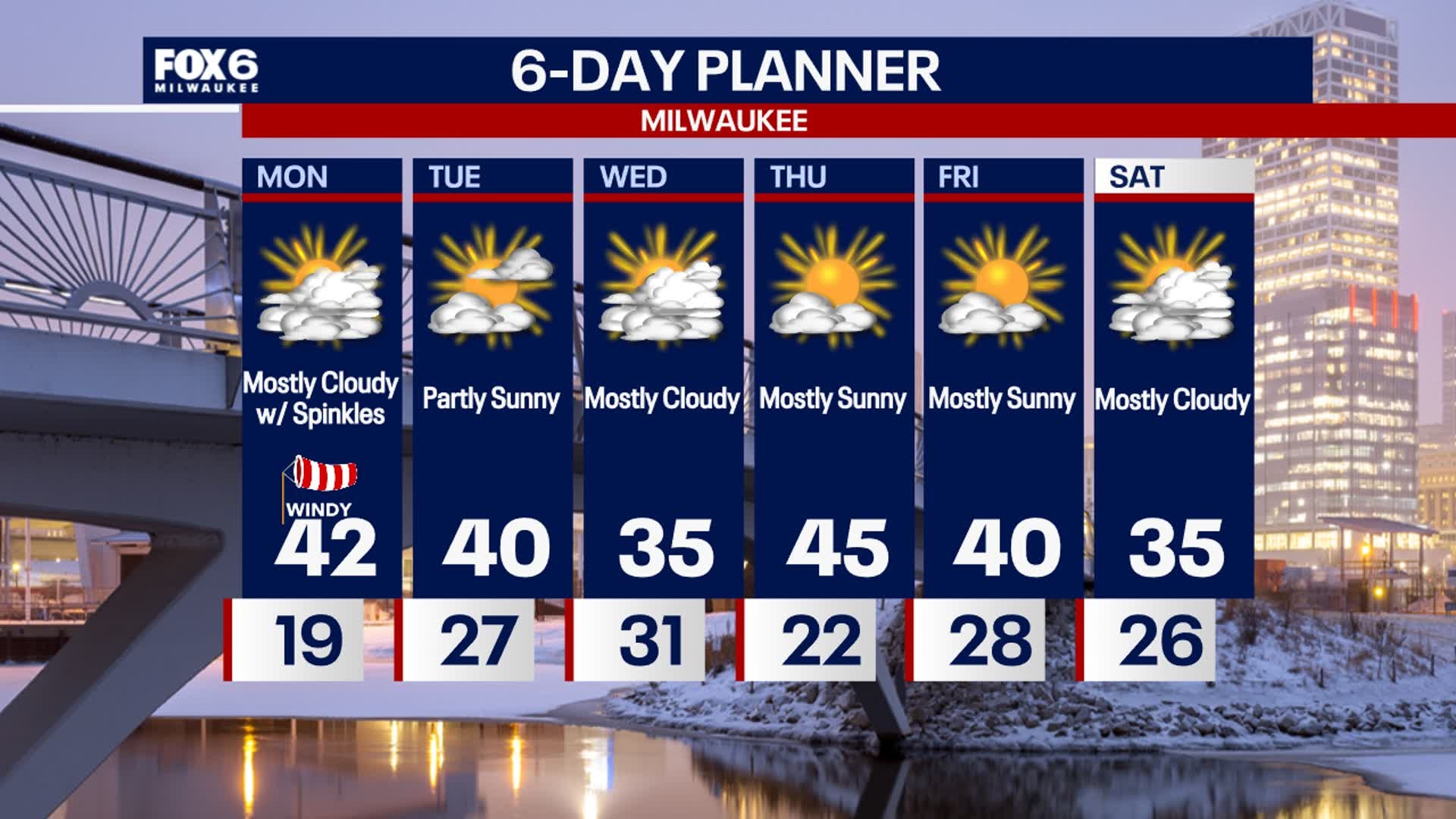
A wind advisory will be in effect starting at 8AM until 6PM.
A wind advisory will be in effect starting at 8AM until 6PM.
Weather webcast with Lisa Michaels
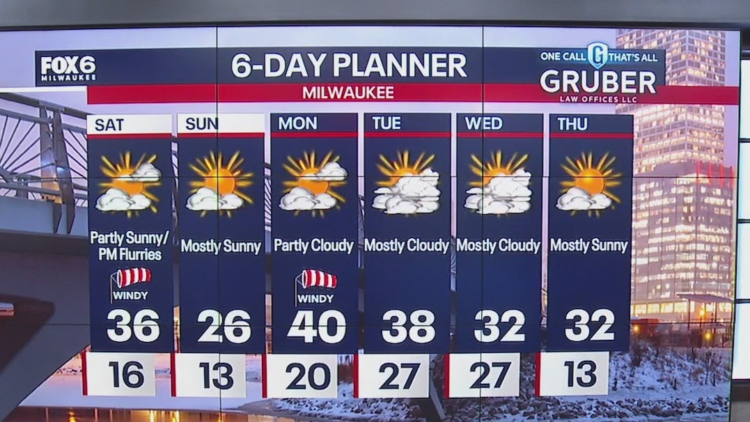
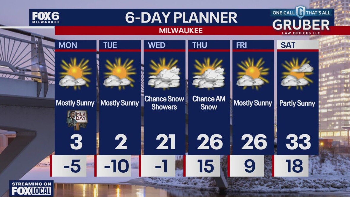
Mostly sunny Sunday with high temperatures cooler in the upper 20s. Mostly clear skies Sunday night with temperatures falling into the upper teens. Winds will begin to increase Sunday night into Monday.
Mostly sunny Sunday with high temperatures cooler in the upper 20s. Mostly clear skies Sunday night with temperatures falling into the upper teens. Winds will begin to increase Sunday night into Monday.

Weather Webcast with Holly Baker
A slight drop in temperatures before another warmup Monday.
A slight drop in temperatures before another warmup Monday.
Weather webcast with Lisa Michaels
Mostly sunny skies in the morning then increasing clouds by the afternoon as a cold front will move through. Winds pick up with a chance of flurries this afternoon and evening. Highs in the mid 30s.
Mostly sunny skies in the morning then increasing clouds by the afternoon as a cold front will move through. Winds pick up with a chance of flurries this afternoon and evening. Highs in the mid 30s.

Weather Webcast with Holly Baker
Temperatures are warming up for Saturday with a chance for flurries.
Temperatures are warming up for Saturday with a chance for flurries.
Weather webcast with Rob Haswell
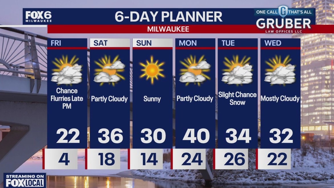
A sunny but cold start to Friday, but we will warm a bit by the afternoon with much warmer air arriving this weekend. Flurries are possible later on Friday and Friday night, but otherwise we will remain dry for several days.
A sunny but cold start to Friday, but we will warm a bit by the afternoon with much warmer air arriving this weekend. Flurries are possible later on Friday and Friday night, but otherwise we will remain dry for several days.
Weather webcast with Rob Haswell
Temperatures will fall from early highs in the low 20s to near 20 this afternoon. Early morning snow showers will end and sunshine will return by midday.
Temperatures will fall from early highs in the low 20s to near 20 this afternoon. Early morning snow showers will end and sunshine will return by midday.

Weather webcast with Lisa Michaels
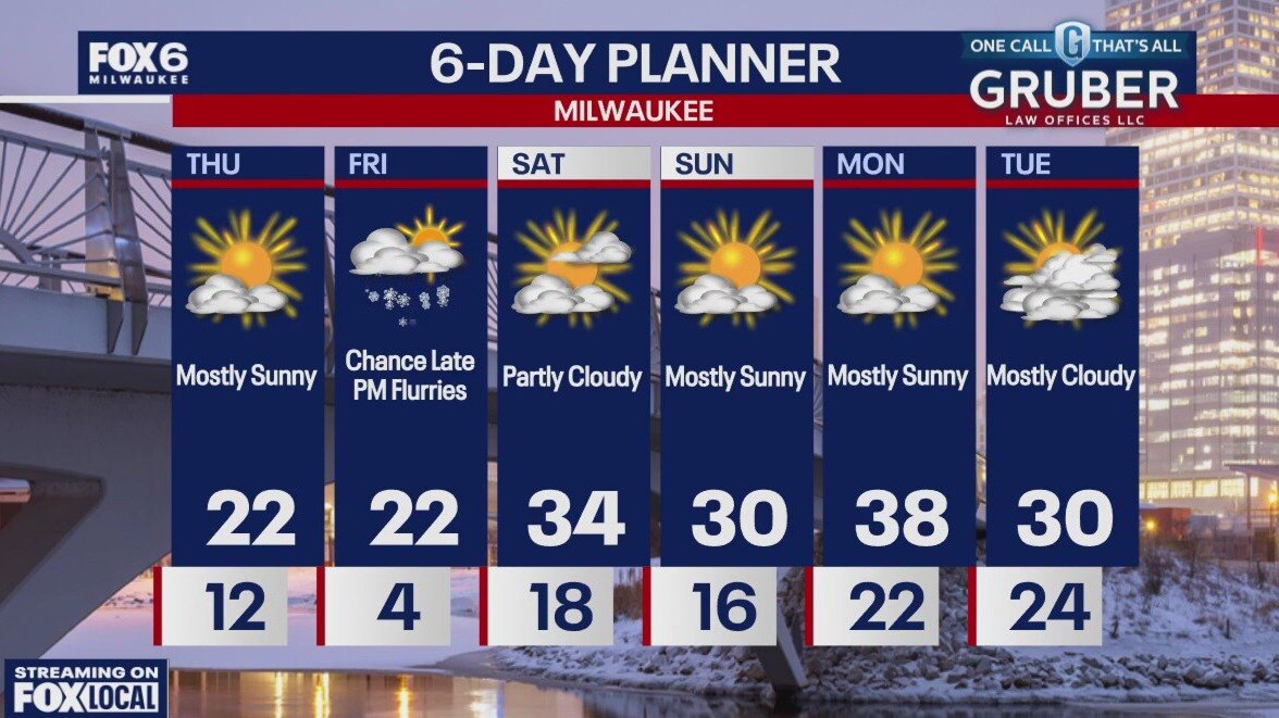
Scattered light snow showers and flurries continue tonight through Thursday morning. Little accumulation expected. A cold front moving through tonight will drop temperatures in the below zero by Thursday morning. Highs will remain in the teens during the afternoon under mostly sunny skies. A long stretch of mostly sunny and dry conditions heading into the weekend and early next week. Warmer temperatures return back in the forecast by the weekend and next week in the 30s and possible 40s by Tuesday.
Scattered light snow showers and flurries continue tonight through Thursday morning. Little accumulation expected. A cold front moving through tonight will drop temperatures in the below zero by Thursday morning. Highs will remain in the teens during the afternoon under mostly sunny skies. A long stretch of mostly sunny and dry conditions heading into the weekend and early next week. Warmer temperatures return back in the forecast by the weekend and next week in the 30s and possible 40s by Tuesday.

Weather webcast with Rob Haswell
An area of low pressure passes over Lake Superior today and brings some warmer air into our region. Highs will be in the low 20s this afternoon.
An area of low pressure passes over Lake Superior today and brings some warmer air into our region. Highs will be in the low 20s this afternoon.

Weather webcast with Lisa Michaels
A cold weather advisory is in effect through midnight tonight where wind chills can drop near -25F. Flurries possible late with snow showers Wednesday through Thursday morning. Accumulation will range from a dusting to 1" for most locations. Temperatures warm heading into the weekend with highs back in the 20s and low 30s. Overall, looking dry with little snow chances heading into the extended forecast.
A cold weather advisory is in effect through midnight tonight where wind chills can drop near -25F. Flurries possible late with snow showers Wednesday through Thursday morning. Accumulation will range from a dusting to 1" for most locations. Temperatures warm heading into the weekend with highs back in the 20s and low 30s. Overall, looking dry with little snow chances heading into the extended forecast.

Weather Webcast with Stephanie Barichello
Sunny and very cold today with air temperatures barely above 0 and wind chills between -15 and -25. Light snow is possible Wednesday with around 1" possible, and temperatures will reach into the 20s. 20s the rest of the week then a chance for 30s this weekend.
Sunny and very cold today with air temperatures barely above 0 and wind chills between -15 and -25. Light snow is possible Wednesday with around 1" possible, and temperatures will reach into the 20s. 20s the rest of the week then a chance for 30s this weekend.

Weather webcast with Rob Haswell
An extreme cold warning began at midnight and is in effect until noon Tuesday with wind chills -30F or below. We won't warm much for Tuesday with more areas hitting highs near zero and feeling sub zero with a steady West wind 10-20mph.
An extreme cold warning began at midnight and is in effect until noon Tuesday with wind chills -30F or below. We won't warm much for Tuesday with more areas hitting highs near zero and feeling sub zero with a steady West wind 10-20mph.

Weather Webcast with Chief Meteorologist Tom Wachs
An Extreme Cold Warning is in effect until Noon on Tuesday. Morning wind chills between -25 and -35. This is dangerous cold. Please check fox6now.com/closings for the latest school closings.
An Extreme Cold Warning is in effect until Noon on Tuesday. Morning wind chills between -25 and -35. This is dangerous cold. Please check fox6now.com/closings for the latest school closings.

Weather Webcast with Chief Meteorologist Tom Wachs
An Extreme Cold Warning is in effect for the entire state of Wisconsin overnight into Tuesday morning. Check fox6now.com/closings for the latest school closings.
An Extreme Cold Warning is in effect for the entire state of Wisconsin overnight into Tuesday morning. Check fox6now.com/closings for the latest school closings.
Weather webcast with Lisa Michaels
A cold weather advisory is in effect until noon on Tuesday for most lakeside counties for dangerously cold wind chills of -29?F. An extreme cold warning starts at midnight and is in effect until noon Tuesday for inland counties with wind chills as cold as -36?F.
A cold weather advisory is in effect until noon on Tuesday for most lakeside counties for dangerously cold wind chills of -29?F. An extreme cold warning starts at midnight and is in effect until noon Tuesday for inland counties with wind chills as cold as -36?F.

Weather Webcast with Holly Baker
A cold weather advisory is extended until noon on Tuesday.
A cold weather advisory is extended until noon on Tuesday.