


Wisconsin's bitter cold led to crash that killed Buddy Holly on Feb. 3, 1959
Wisconsin winter cold and snow blamed for the deaths of legendary rock stars February 3rd, 1959.
Wisconsin winter cold and snow blamed for the deaths of legendary rock stars February 3rd, 1959.
Weather webcast with Rob Haswell
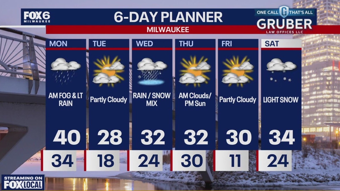
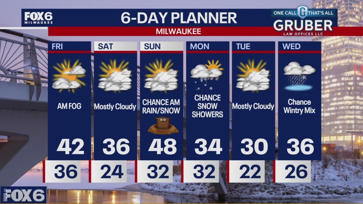
Patchy fog and some light rain early on our Monday morning but mild. Highs will reach the upper 30s and low 40s early today then fall late afternoon.
Patchy fog and some light rain early on our Monday morning but mild. Highs will reach the upper 30s and low 40s early today then fall late afternoon.
Weather Webcast with Chief Meteorologist Tom Wachs
Dense fog will develop overnight with a chance for a light wintry mix as well. Temperatures will drop through the 30s. Mostly cloudy and blustery on Monday with a few light rain/snow showers. Highs in the upper 30s.
Dense fog will develop overnight with a chance for a light wintry mix as well. Temperatures will drop through the 30s. Mostly cloudy and blustery on Monday with a few light rain/snow showers. Highs in the upper 30s.
Weather Webcast with Chief Meteorologist Tom Wachs
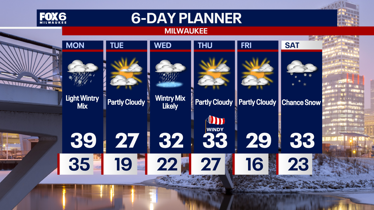
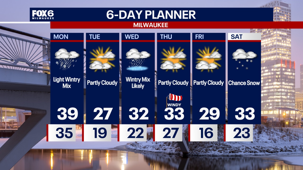
Dense fog will develop overnight with temperatures in the 30s. A light wintry mix is also possible north of Milwaukee overnight. Light rain/snow is possible on Monday, otherwise blustery with highs in the upper 30s.
Dense fog will develop overnight with temperatures in the 30s. A light wintry mix is also possible north of Milwaukee overnight. Light rain/snow is possible on Monday, otherwise blustery with highs in the upper 30s.
Weather webcast with Stephanie Barichello
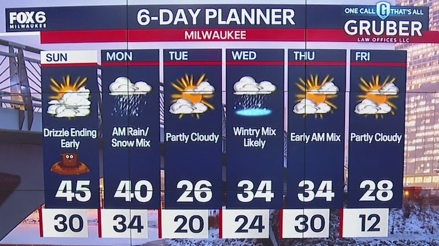
Light drizzle ends this morning and clouds decrease throughout the day. Temperatures will reach into the low and middle 40s. There is another chance for rain/snow mix, especially across northern counties, tonight and Monday morning.
Light drizzle ends this morning and clouds decrease throughout the day. Temperatures will reach into the low and middle 40s. There is another chance for rain/snow mix, especially across northern counties, tonight and Monday morning.

Weather Webcast with Holly Baker
Tracking snow showers tonight and tomorrow morning!
Tracking snow showers tonight and tomorrow morning!
Weather webcast with Lisa Michaels
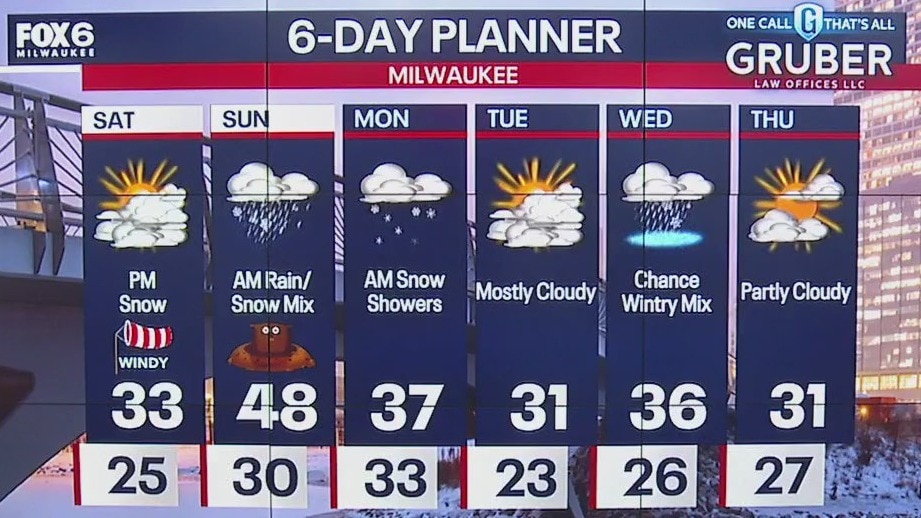
Highs will be in the low 30s with wind chills in the 20s due to breezy winds. Snow possible tonight after 7PM through early Sunday morning. A mix is favorable by Sunday morning with freezing drizzle possible.
Highs will be in the low 30s with wind chills in the 20s due to breezy winds. Snow possible tonight after 7PM through early Sunday morning. A mix is favorable by Sunday morning with freezing drizzle possible.

Weather Webcast with Holly Baker
Snow arrives in the forecast late Saturday night.
Snow arrives in the forecast late Saturday night.
Weather webcast with Rob Haswell
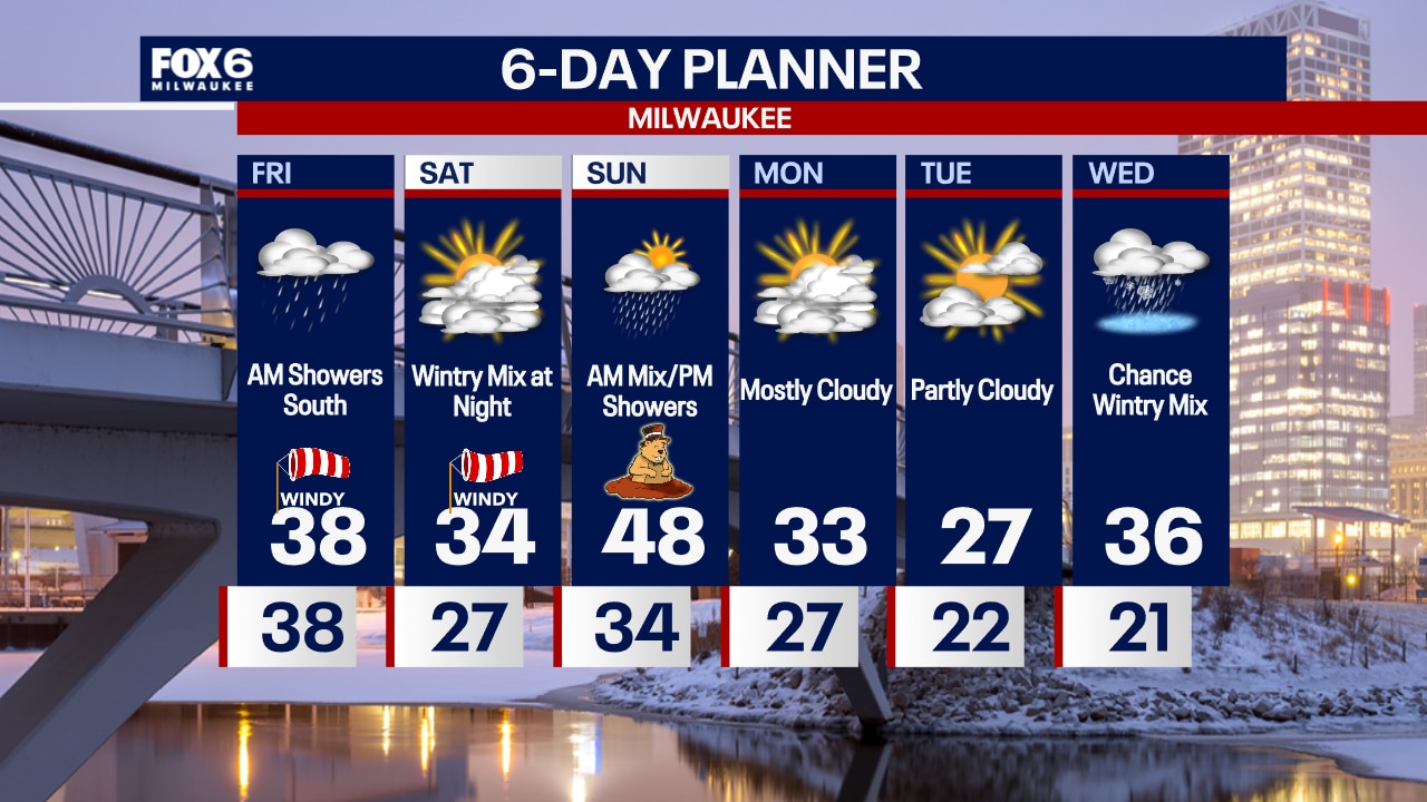
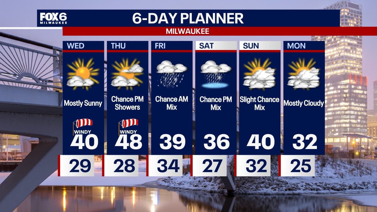
A Dense Fog Advisory is in effect until 9 a.m .Friday with visibility in some areas near zero. Drive with care. Not as mild to wrap up the work week but still well above average with highs in the low 40s expected.
A Dense Fog Advisory is in effect until 9 a.m .Friday with visibility in some areas near zero. Drive with care. Not as mild to wrap up the work week but still well above average with highs in the low 40s expected.
Weather Webcast with Chief Meteorologist Tom Wachs
Areas of dense fog overnight with light rain showers south of Milwaukee. Temperatures in the 30s. AM light rain south of Milwaukee on Friday, otherwise windy with afternoon peeks of the sun. Highs in the upper 30s.
Areas of dense fog overnight with light rain showers south of Milwaukee. Temperatures in the 30s. AM light rain south of Milwaukee on Friday, otherwise windy with afternoon peeks of the sun. Highs in the upper 30s.

Weather Webcast with Chief Meteorologist Tom Wachs
Dense fog possible overnight. Light rain showers also possible overnight into Friday morning mainly south of Milwaukee. Temperatures in the 30s in the morning and upper 30s in the afternoon. The wind will pick up out of the northeast on Friday with peeks of the sun by afternoon.
Dense fog possible overnight. Light rain showers also possible overnight into Friday morning mainly south of Milwaukee. Temperatures in the 30s in the morning and upper 30s in the afternoon. The wind will pick up out of the northeast on Friday with peeks of the sun by afternoon.
Weather Webcast with Chief Meteorologist Tom Wachs
Increasing clouds tonight with a few rain showers overnight, mainly south of Milwaukee. A few light rain showers and possibly a wintry mix at times on Friday morning, also mainly south of Milwaukee. Otherwise windy and cooler with highs in the upper 30s.
Increasing clouds tonight with a few rain showers overnight, mainly south of Milwaukee. A few light rain showers and possibly a wintry mix at times on Friday morning, also mainly south of Milwaukee. Otherwise windy and cooler with highs in the upper 30s.

Weather webcast with Rob Haswell
A very mild Thursday expected with highs well into the 50s by this afternoon. We start sunny but get cloudy later in the day with a chance for rain or a wintry mix overnight into Friday morning.
A very mild Thursday expected with highs well into the 50s by this afternoon. We start sunny but get cloudy later in the day with a chance for rain or a wintry mix overnight into Friday morning.
Weather Webcast with Chief Meteorologist Tom Wachs
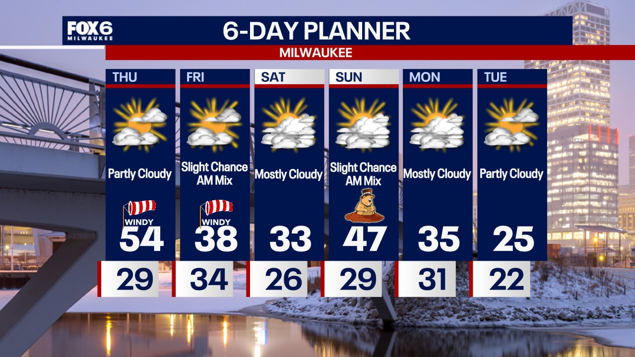
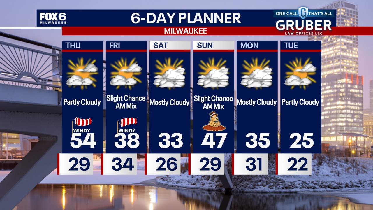
Mostly clear overnight with temperatures dropping into the 20s. Partly sunny, windy & warm on Thursday with a record high of 54.
Mostly clear overnight with temperatures dropping into the 20s. Partly sunny, windy & warm on Thursday with a record high of 54.
Weather Webcast with Chief Meteorologist Tom Wachs
Clear and quiet tonight with temperatures dropping into the 20s overnight. We are on Record Watch on Thursday with a possible record high in the mid-50s.
Clear and quiet tonight with temperatures dropping into the 20s overnight. We are on Record Watch on Thursday with a possible record high in the mid-50s.
Weather webcast with Rob Haswell
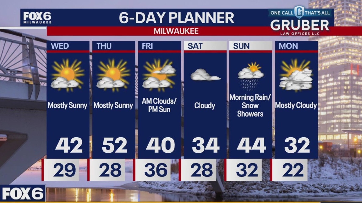
Breezy and mild again for this Wednesday. Highs will warm into the low 40s by the afternoon. We stay mostly sunny today and mostly clear and mild overnight as we stay in the upper 20s into early Thursday morning.
Breezy and mild again for this Wednesday. Highs will warm into the low 40s by the afternoon. We stay mostly sunny today and mostly clear and mild overnight as we stay in the upper 20s into early Thursday morning.
Weather Webcast with Chief Meteorologist Tom Wachs
Mostly clear and windy overnight with temperatures falling through the 30s. Mostly sunny and windy on Wednesday with a high around 40.
Mostly clear and windy overnight with temperatures falling through the 30s. Mostly sunny and windy on Wednesday with a high around 40.
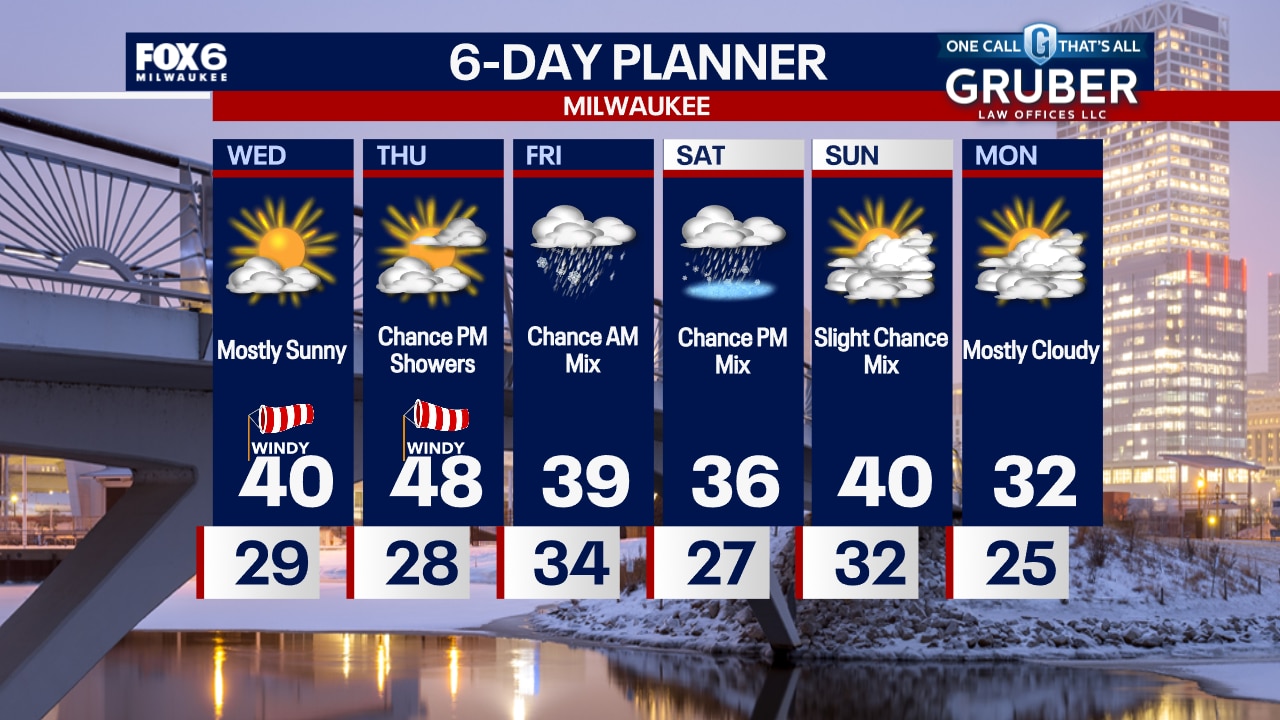
Weather Webcast with Chief Meteorologist Tom Wachs
It will stay windy tonight with temperatures dropping through the 30s. Mostly sunny and windy again on Wednesday with a high around 40.
It will stay windy tonight with temperatures dropping through the 30s. Mostly sunny and windy again on Wednesday with a high around 40.
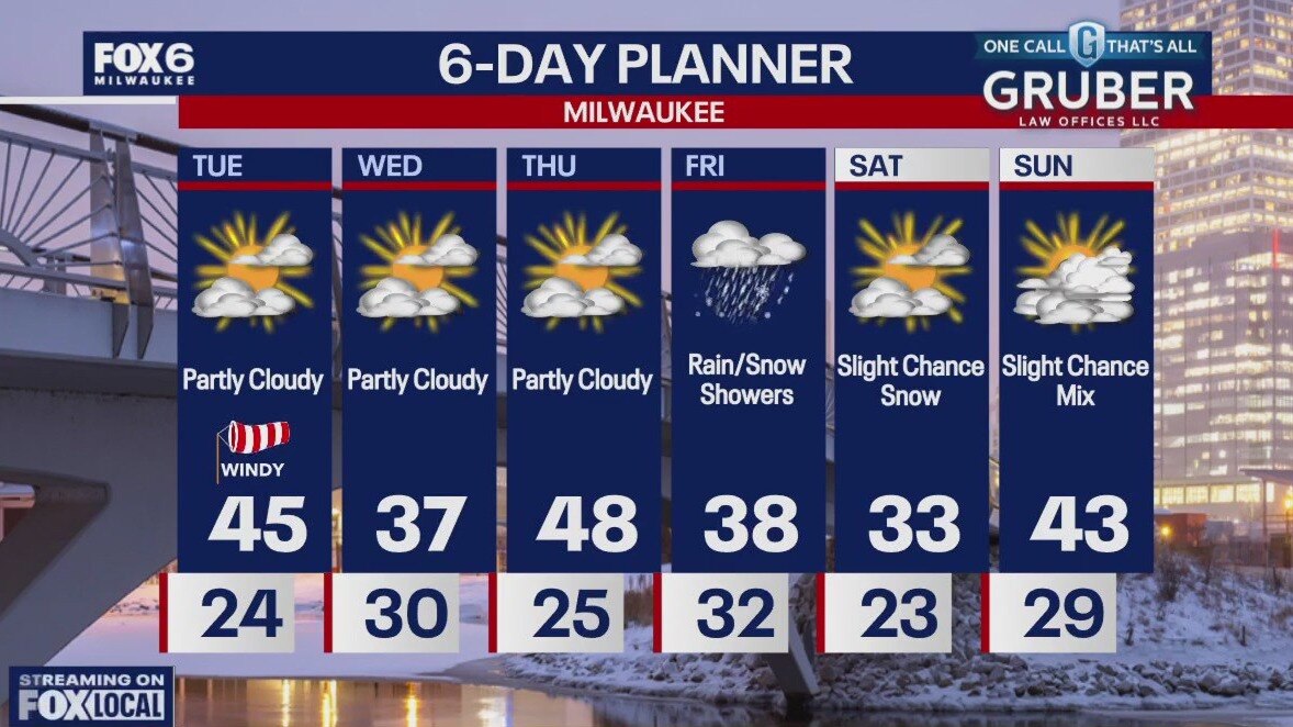
Weather webcast with Lisa Michaels
Winds will pick up during the afternoon allowing a new Wind Advisory to be issued from 1PM to 6PM Tuesday for gusts near 50mph. Partly cloudy to mostly cloudy skies Tuesday with highs reaching 40F.
Winds will pick up during the afternoon allowing a new Wind Advisory to be issued from 1PM to 6PM Tuesday for gusts near 50mph. Partly cloudy to mostly cloudy skies Tuesday with highs reaching 40F.
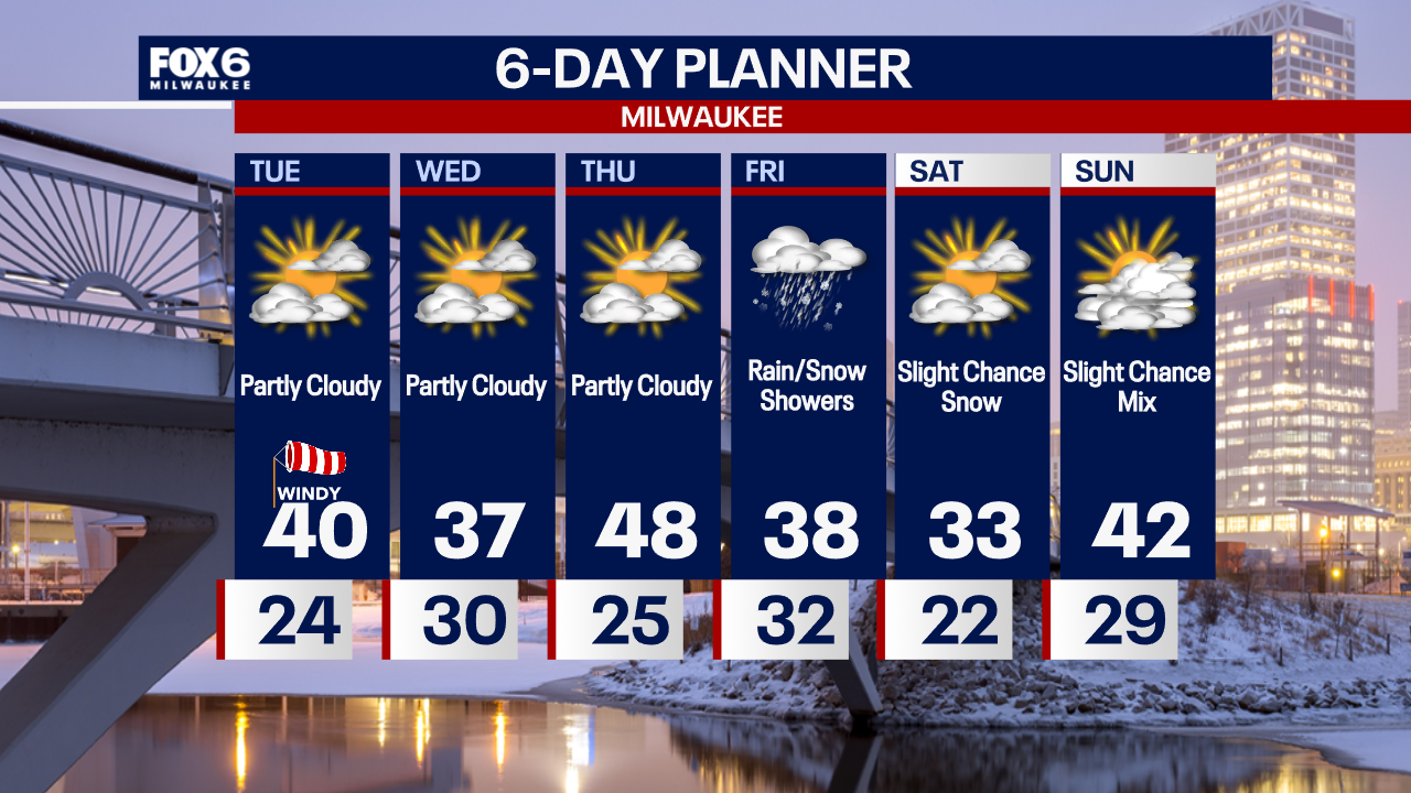
Weather Webcast with Chief Meteorologist Tom Wachs
Partly cloudy and not as windy overnight. Temperatures dropping into the 20s. Increasing clouds on Tuesday with the wind picking back up. High temperatures around 40.
Partly cloudy and not as windy overnight. Temperatures dropping into the 20s. Increasing clouds on Tuesday with the wind picking back up. High temperatures around 40.