

Weather Webcast with Chief Meteorologist Tom Wachs
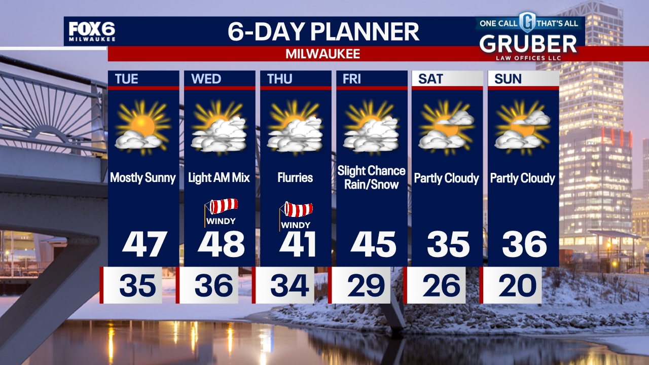
A few rain showers are possible tonight. Temperatures will drop into the 30s overnight. Mostly sunny and warm again on Tuesday with highs in the mid-to-upper 40s.
A few rain showers are possible tonight. Temperatures will drop into the 30s overnight. Mostly sunny and warm again on Tuesday with highs in the mid-to-upper 40s.

Weather webcast with Rob Haswell
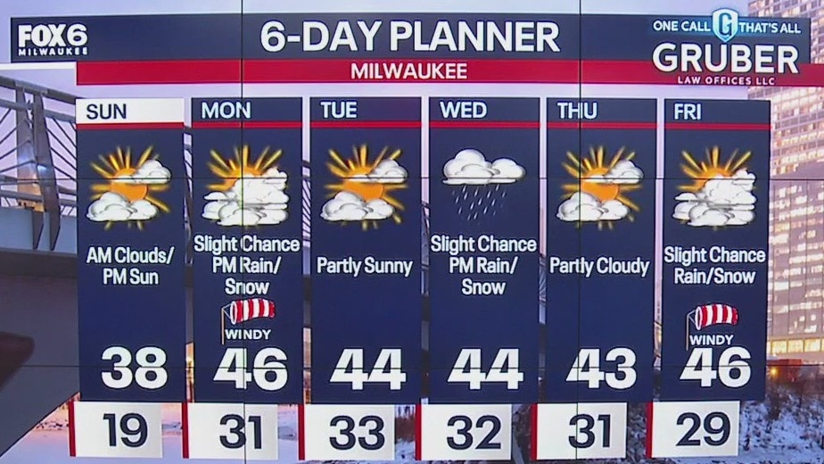
Very mild air continues to dominate our forecast Monday with highs pushing 10-15 degrees above the climate averages. We stay mild overnight with some drizzle and fog developing.
Very mild air continues to dominate our forecast Monday with highs pushing 10-15 degrees above the climate averages. We stay mild overnight with some drizzle and fog developing.
Weather Webcast with Chief Meteorologist Tom Wachs
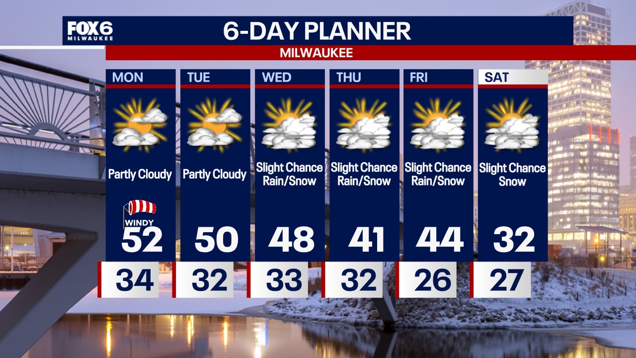
Increasing clouds overnight with temperatures holding steady in the 30s. Partly to mostly cloudy, windy and warm on Monday with highs in the upper 40s to low 50s.
Increasing clouds overnight with temperatures holding steady in the 30s. Partly to mostly cloudy, windy and warm on Monday with highs in the upper 40s to low 50s.

Weather Webcast with Chief Meteorologist Tom Wachs
Mild tonight with temperatures holding in the 30s. Partly to mostly cloudy on Monday, windy and warm. Highs in the upper 40s to low 50s.
Mild tonight with temperatures holding in the 30s. Partly to mostly cloudy on Monday, windy and warm. Highs in the upper 40s to low 50s.
Weather webcast with Lisa Michaels
Thicker clouds start off Sunday but will gradually decrease during the afternoon. Highs in the upper 30s. Warming and above average temperatures return for the last week of February.
Thicker clouds start off Sunday but will gradually decrease during the afternoon. Highs in the upper 30s. Warming and above average temperatures return for the last week of February.

Weather Webcast with Holly Baker
Temperatures continue to warm up.
Temperatures continue to warm up.

Weather webcast with Lisa Michaels
Partly sunny Saturday with high temps in the upper 20s to low 30s. Wind chills remain in the teens. Winds increasing out of the southwest that could be breezy near the lake.
Partly sunny Saturday with high temps in the upper 20s to low 30s. Wind chills remain in the teens. Winds increasing out of the southwest that could be breezy near the lake.

Webcast Weather with Holly Baker
Warmer temperatures are on the way.
Warmer temperatures are on the way.

Weather webcast with Lisa Michaels
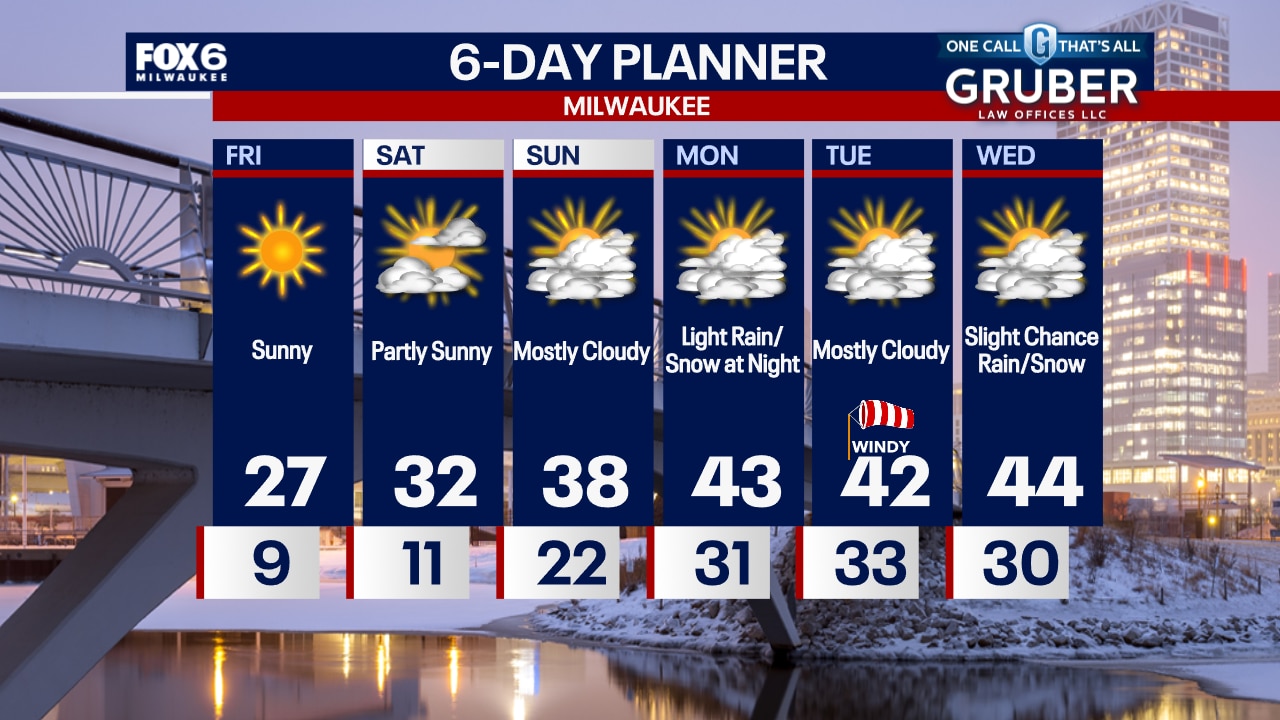
Morning wind chills -5 to 5 at times. Sunny Friday with high temps in the mid to upper 20s. Dry & warming into the 30s by the weekend with upper 30s by Sunday.
Morning wind chills -5 to 5 at times. Sunny Friday with high temps in the mid to upper 20s. Dry & warming into the 30s by the weekend with upper 30s by Sunday.

Weather Webcast with Chief Meteorologist Tom Wachs
Clear and cold overnight with wind chills between 0 and -5 by morning. Abundant sunshine on Friday with highs in the upper 20s. Getting even warmer this weekend with highs in the 30s.
Clear and cold overnight with wind chills between 0 and -5 by morning. Abundant sunshine on Friday with highs in the upper 20s. Getting even warmer this weekend with highs in the 30s.
Weather Webcast with Chief Meteorologist Tom Wachs
Clear and cold tonight with wind chills around 0 to -5 by morning. Abundant sunshine on Friday with highs in the mid-to-upper 20s. Getting even warmer this weekend.
Clear and cold tonight with wind chills around 0 to -5 by morning. Abundant sunshine on Friday with highs in the mid-to-upper 20s. Getting even warmer this weekend.

Weather webcast with Holly Baker
Skies will be partly sunny today. Wind chill values still could be low in the single digits. Mostly sunny with temperatures slightly warmer for Friday.
Skies will be partly sunny today. Wind chill values still could be low in the single digits. Mostly sunny with temperatures slightly warmer for Friday.
Weather Webcast with Chief Meteorologist Tom Wachs
Cold again tonight with wind chills between 0 and -15. Becoming partly cloudy on Thursday with a blustery high in the low 20s and afternoon wind chills in the single digits to low teens.
Cold again tonight with wind chills between 0 and -15. Becoming partly cloudy on Thursday with a blustery high in the low 20s and afternoon wind chills in the single digits to low teens.
Weather webcast with Lisa Michaels
Increasing clouds & cold again tonight. Wind chills dropping as low as -20°F near the lake by morning, -28°F inland.
Increasing clouds & cold again tonight. Wind chills dropping as low as -20°F near the lake by morning, -28°F inland.

Weather webcast with Lisa Michaels
Increasing clouds & cold again tonight. Wind chills dropping as low as -20?F near the lake by morning, -28?F inland.
Increasing clouds & cold again tonight. Wind chills dropping as low as -20?F near the lake by morning, -28?F inland.

Weather webcast with Lisa Michaels
Increasing clouds & cold again tonight. Wind chills dropping as low as -20 near the lake by morning, -28 inland.
Increasing clouds & cold again tonight. Wind chills dropping as low as -20 near the lake by morning, -28 inland.
Weather Webcast with Chief Meteorologist Tom Wachs
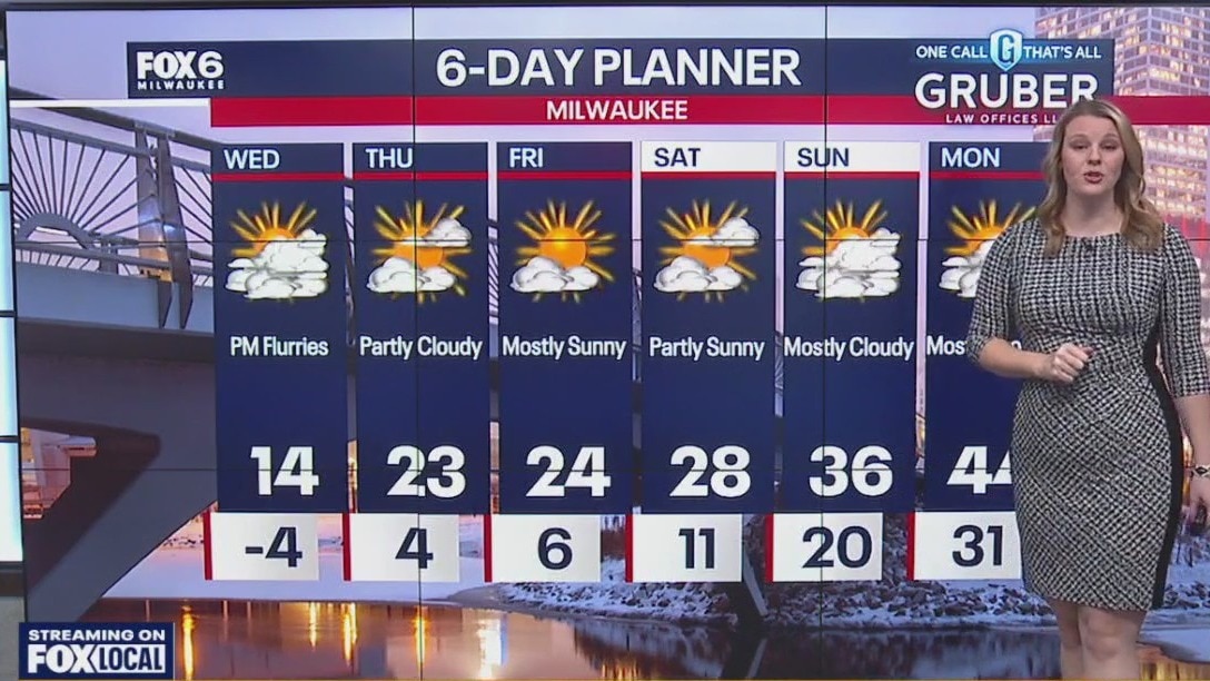
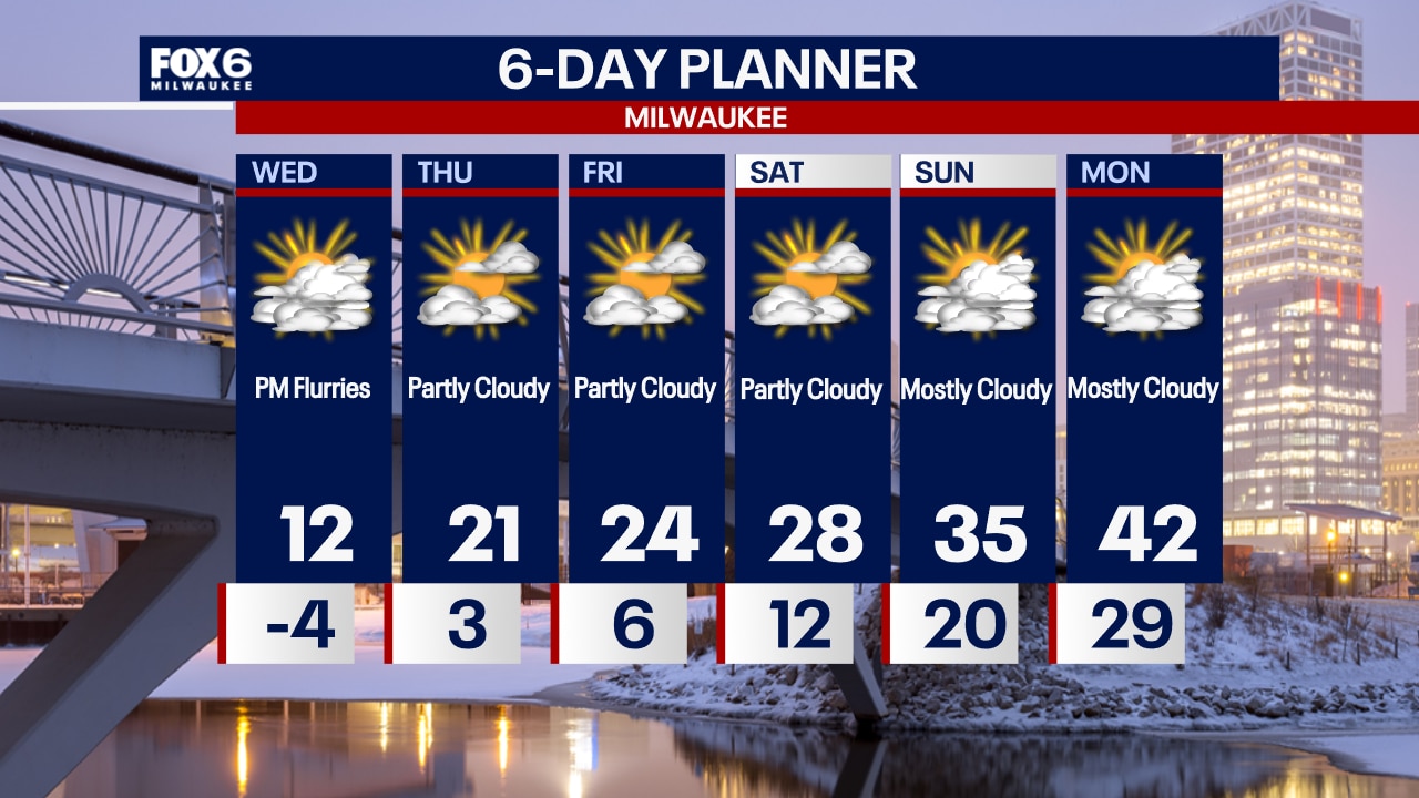
A Cold Weather Advisory is in effect until 10am Wednesday. AM wind chills -20 to -28. Another bitterly cold day on Wednesday with a slow climb out of this through the end of the week.
A Cold Weather Advisory is in effect until 10am Wednesday. AM wind chills -20 to -28. Another bitterly cold day on Wednesday with a slow climb out of this through the end of the week.

Weather webcast with Chief Meteorologist Rob Haswell
A Cold Weather Advisory is in effect until Noon Tuesday. Morning lows will be sub-zero and feel colder than -20 at times. Highs will reach 10 degrees with ample sun.
A Cold Weather Advisory is in effect until Noon Tuesday. Morning lows will be sub-zero and feel colder than -20 at times. Highs will reach 10 degrees with ample sun.

Weather webcast with Lisa Michaels
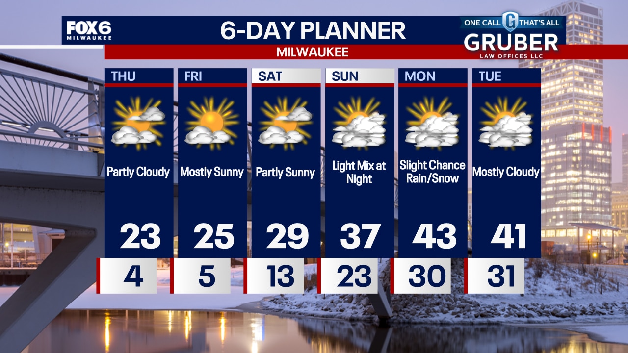
Mostly clear skies tonight with temps dropping below zero. A Cold Weather Advisory is in effect from 9PM Monday until Tuesday 12PM. Wind chills will be 20 to 29 below zero. We will be dry majority of the week. However, there is a slight chance for flurries on Wednesday night. A slight warm up arrives by the end of the week with highs back in the mid 20s and 30s by the weekend.
Mostly clear skies tonight with temps dropping below zero. A Cold Weather Advisory is in effect from 9PM Monday until Tuesday 12PM. Wind chills will be 20 to 29 below zero. We will be dry majority of the week. However, there is a slight chance for flurries on Wednesday night. A slight warm up arrives by the end of the week with highs back in the mid 20s and 30s by the weekend.

Weather webcast with Rob Haswell
A bitterly cold stretch begins Monday and continues through most of the week. A Cold Weather Advisory is in place today with another set for tomorrow. Wind chills at times will be 20 to 25 below zero.
A bitterly cold stretch begins Monday and continues through most of the week. A Cold Weather Advisory is in place today with another set for tomorrow. Wind chills at times will be 20 to 25 below zero.