


Weather Webcast with Chief Meteorologist Tom Wachs
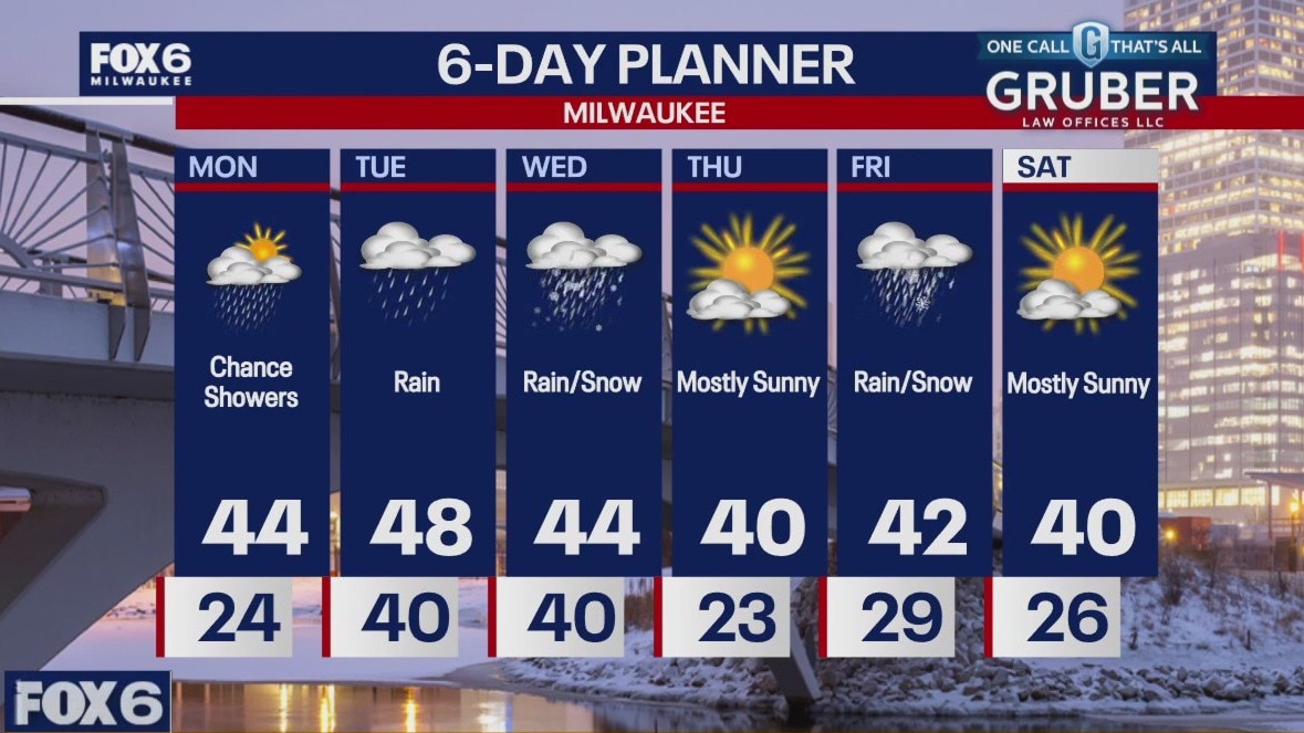
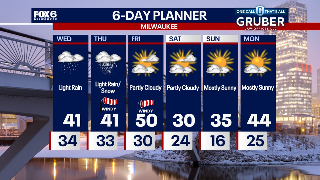
Rainy & blustery all night. Temperatures holding steady in the 40s. Rain continues on Wednesday before changing to snow by mid-to-late afternoon. Falling temperatures late in the day as well with gusty northwest winds.
Rainy & blustery all night. Temperatures holding steady in the 40s. Rain continues on Wednesday before changing to snow by mid-to-late afternoon. Falling temperatures late in the day as well with gusty northwest winds.

Weather webcast with Rob Haswell
An area of low pressure brings rain for Tuesday and into Wednesday with many areas seeing an inch or more by late Wednesday evening.
An area of low pressure brings rain for Tuesday and into Wednesday with many areas seeing an inch or more by late Wednesday evening.

Weather Webcast with Chief Meteorologist Tom Wachs
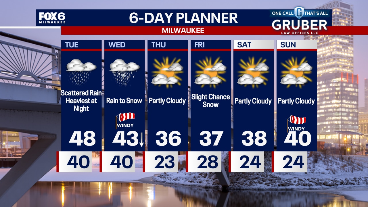
Rain moves in overnight with temperatures around 40. Scattered rain showers on Tuesday with a high in the upper 40s. Moderate to heavy rain moves in from the south late Tuesday afternoon into Tuesday night.
Rain moves in overnight with temperatures around 40. Scattered rain showers on Tuesday with a high in the upper 40s. Moderate to heavy rain moves in from the south late Tuesday afternoon into Tuesday night.
Weather Webcast with Chief Meteorologist Tom Wachs
Rain will move in after 2am and continue off-and-on during the day Tuesday. Highs in the upper 40s. A moderate to heavy batch of rain will move in from the south late on Tuesday afternoon into Tuesday night. Around 1" of rain is expected.
Rain will move in after 2am and continue off-and-on during the day Tuesday. Highs in the upper 40s. A moderate to heavy batch of rain will move in from the south late on Tuesday afternoon into Tuesday night. Around 1" of rain is expected.
Weather webcast with Rob Haswell
Some early sunshine Monday but then getting cloudy with a few showers possible. Highs will warm into the low to mid 40s today.
Some early sunshine Monday but then getting cloudy with a few showers possible. Highs will warm into the low to mid 40s today.

Weather Webcast with Holly Baker
Warm and wet conditions trend for the upcoming week.
Warm and wet conditions trend for the upcoming week.

Weather webcast with Lisa Michaels
Mostly sunny Sunday with warmer temperatures in the mid 30s. Warmer and above average temperatures return for the first week of March in the 40s.
Mostly sunny Sunday with warmer temperatures in the mid 30s. Warmer and above average temperatures return for the first week of March in the 40s.

Webcast Weather with Holly Baker
Another sunny and cool day is expected for Sunday.
Another sunny and cool day is expected for Sunday.
Weather webcast with Lisa Michaels
Temperatures will be colder on Saturday with highs in the upper 20s mostly sunny skies. Dry this weekend with more sunshine on Sunday and highs in the mid 30s.
Temperatures will be colder on Saturday with highs in the upper 20s mostly sunny skies. Dry this weekend with more sunshine on Sunday and highs in the mid 30s.

Weather Webcast with Holly Baker
Temperatures will drop over the weekend.
Temperatures will drop over the weekend.

Weather webcast with Rob Haswell
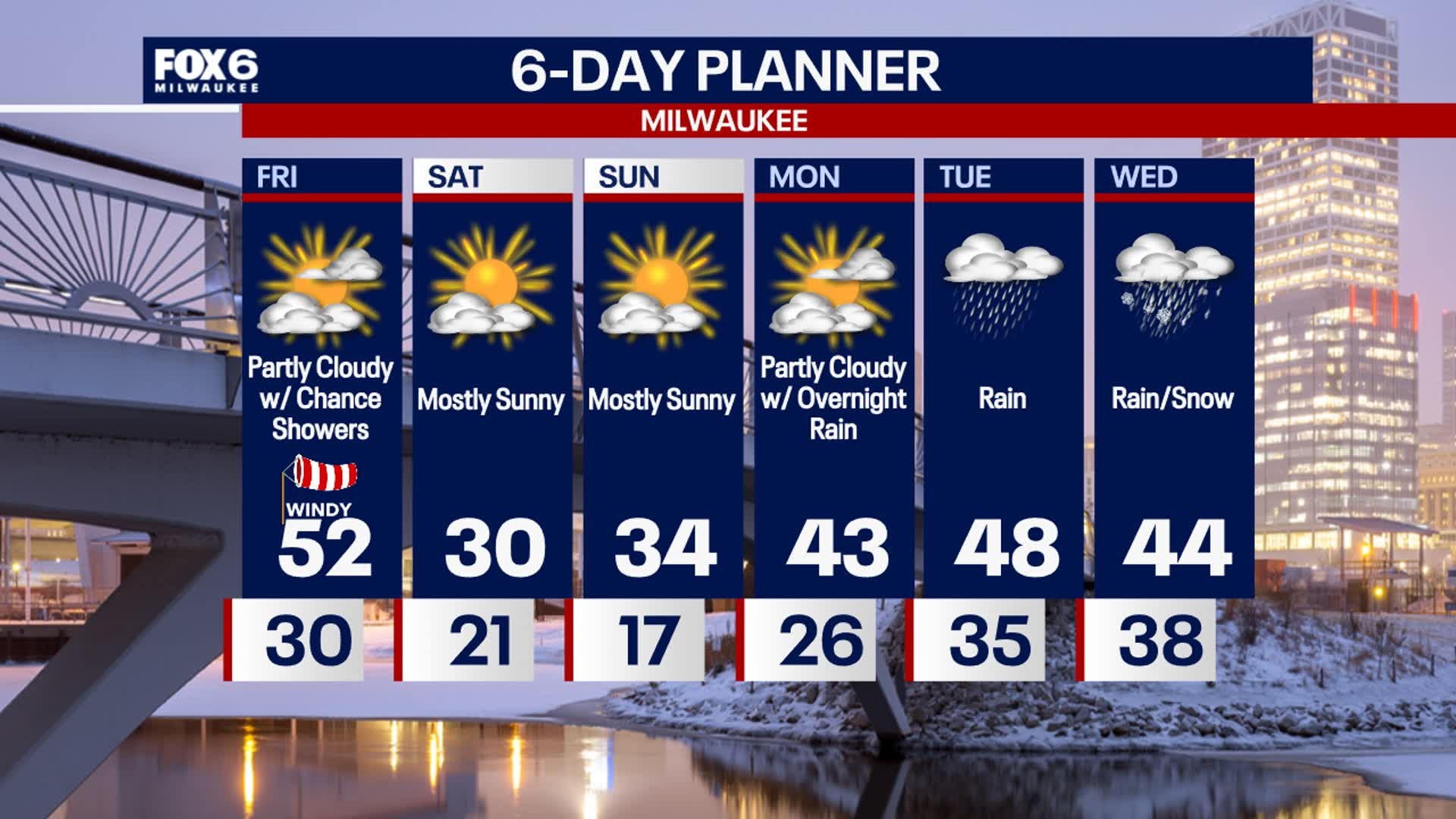
Ahead of a strong area of low pressure on Friday, our area warms up as gusty SW winds drive warm air north. Highs today will reach the low 50s.
Ahead of a strong area of low pressure on Friday, our area warms up as gusty SW winds drive warm air north. Highs today will reach the low 50s.
Weather Webcast with Holly Baker
A wind advisory will be in effect tomorrow.
A wind advisory will be in effect tomorrow.

Weather webcast with Rob Haswell
Mostly cloudy throughout the day with a slight chance for afternoon showers. Highs will again be seasonally mild in the low to mid 40s.
Mostly cloudy throughout the day with a slight chance for afternoon showers. Highs will again be seasonally mild in the low to mid 40s.

Weather Webcast with Holly Baker
A cool down is expected for the weekend.
A cool down is expected for the weekend.
Weather webcast with Rob Haswell
Light rain moving through Wednesday morning will mean wet roads for the morning commute and some areas may be icy with air and road surface temperatures at or below freezing.
Light rain moving through Wednesday morning will mean wet roads for the morning commute and some areas may be icy with air and road surface temperatures at or below freezing.

Weather Webcast with Chief Meteorologist Tom Wachs
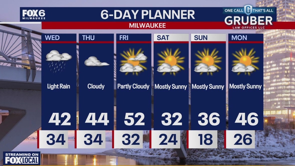
Light rain will move in overnight. Some icing is possible, especially on elevated surfaces. Temperatures in the 30s overnight. Light rain on Wednesday, especially in the morning. Mostly cloudy and drizzly in the afternoon with highs in the low 40s.
Light rain will move in overnight. Some icing is possible, especially on elevated surfaces. Temperatures in the 30s overnight. Light rain on Wednesday, especially in the morning. Mostly cloudy and drizzly in the afternoon with highs in the low 40s.
Weather Webcast with Chief Meteorologist Tom Wachs
Light rain will move in overnight and continue off-and-on during the day on Wednesday. It'll be a cooler day with highs in the low 40s.
Light rain will move in overnight and continue off-and-on during the day on Wednesday. It'll be a cooler day with highs in the low 40s.

Weather webcast with Rob Haswell
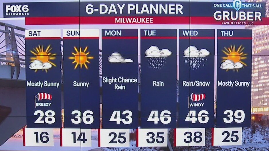
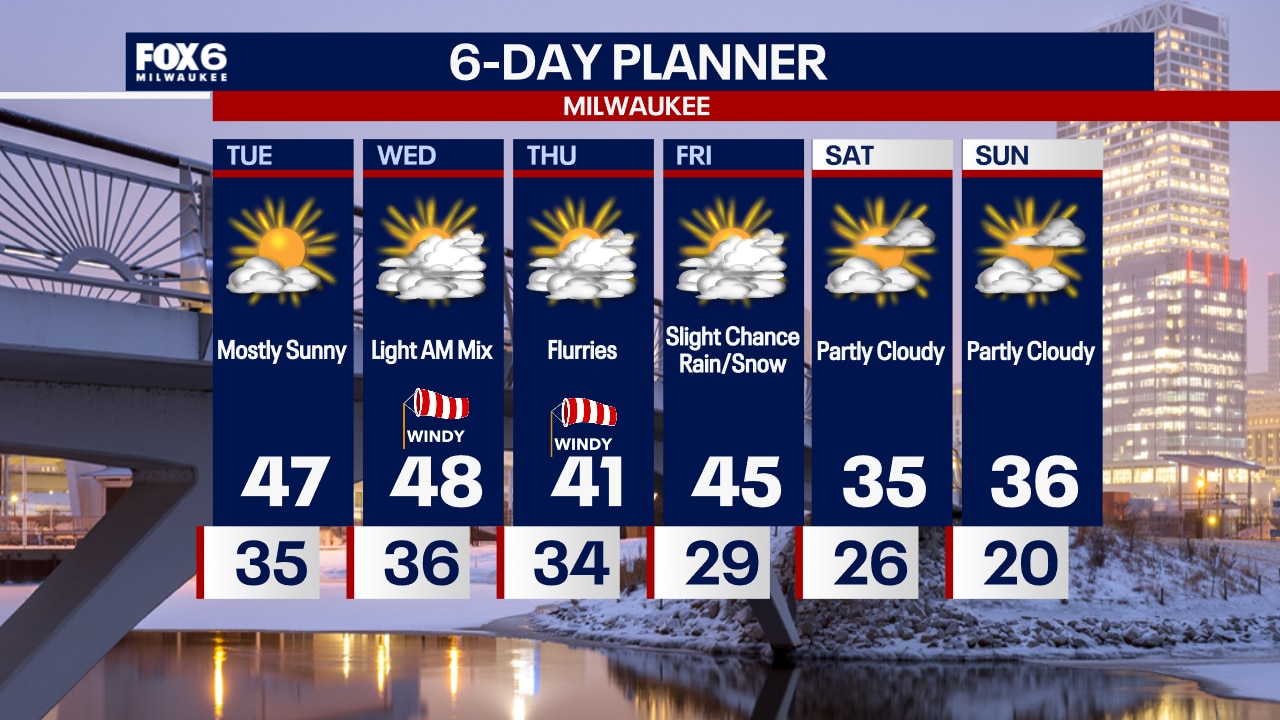
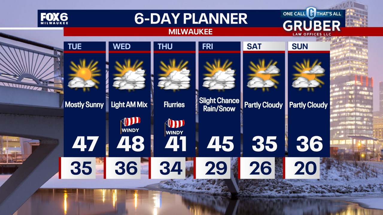
A ridge of high pressure builds across our area for Tuesday giving us ample sun and another mild day with highs in the upper 40s. A low arrives overnight with a chance for rain on Wednesday.
A ridge of high pressure builds across our area for Tuesday giving us ample sun and another mild day with highs in the upper 40s. A low arrives overnight with a chance for rain on Wednesday.
Weather Webcast with Chief Meteorologist Tom Wachs
A few light rain showers are possible overnight with temperatures falling into the 30s. Mostly sunny and warm again on Tuesday with highs in the mid-to-upper 40s. A light wintry mix is possible Wednesday morning.
A few light rain showers are possible overnight with temperatures falling into the 30s. Mostly sunny and warm again on Tuesday with highs in the mid-to-upper 40s. A light wintry mix is possible Wednesday morning.
Weather Webcast with Chief Meteorologist Tom Wachs
A few rain showers are possible tonight. Temperatures will drop into the 30s overnight. Mostly sunny and warm again on Tuesday with highs in the mid-to-upper 40s.
A few rain showers are possible tonight. Temperatures will drop into the 30s overnight. Mostly sunny and warm again on Tuesday with highs in the mid-to-upper 40s.