

Weather webcast with Lisa Michaels
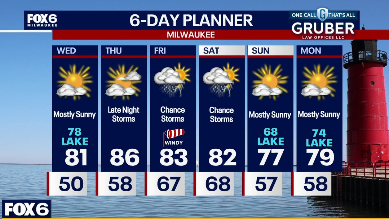
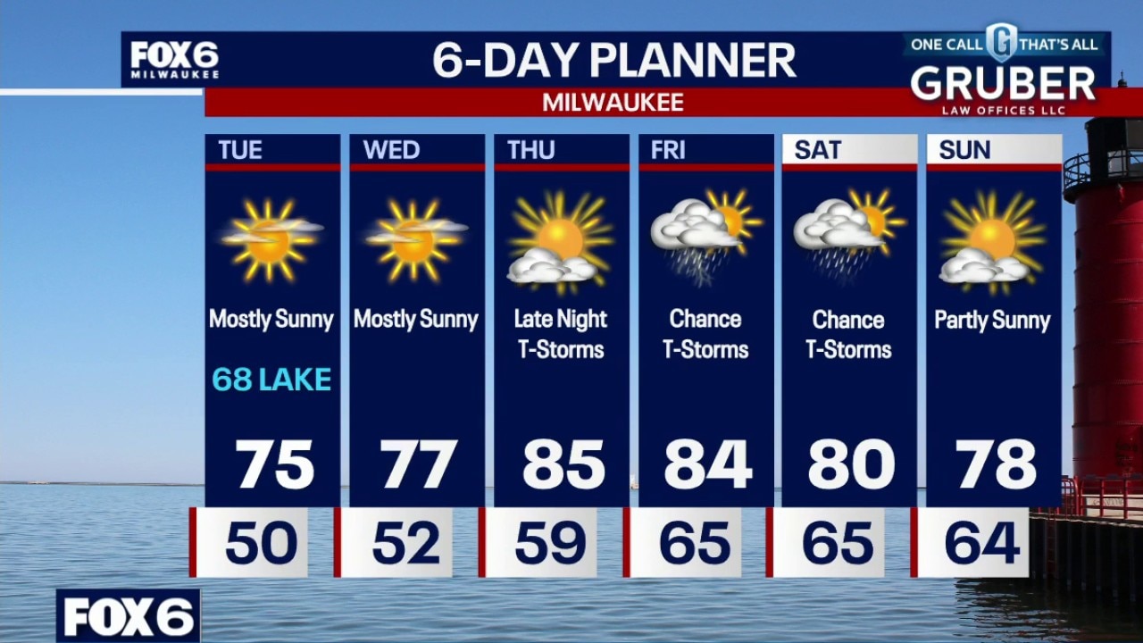
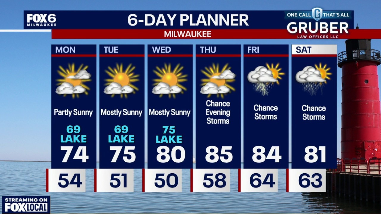
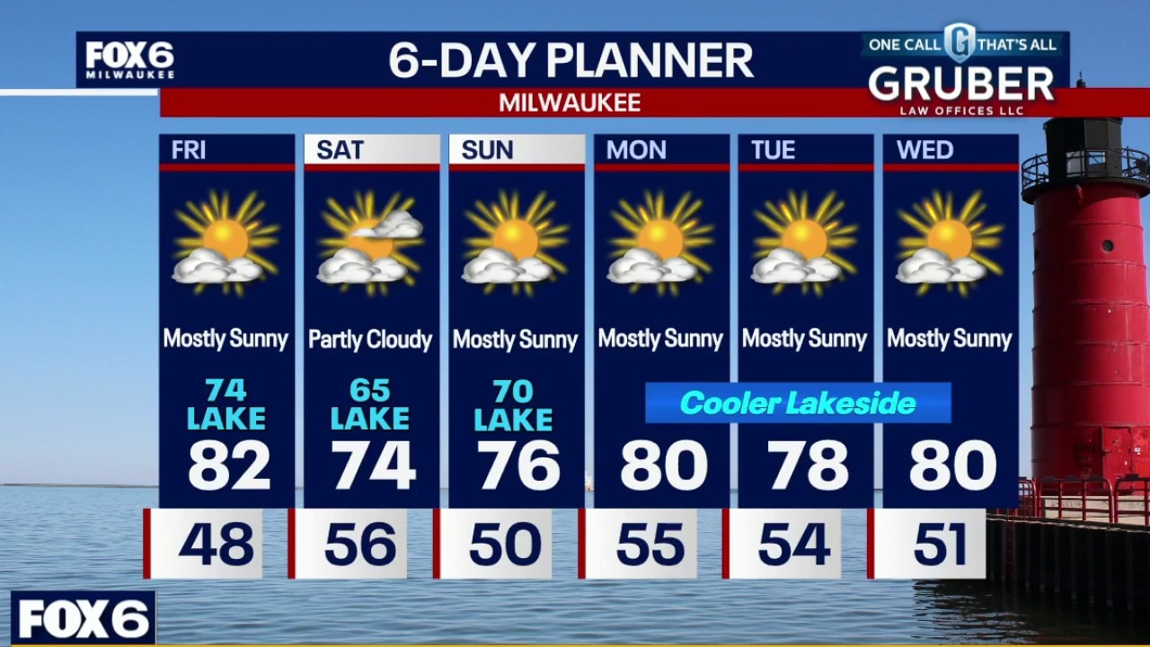
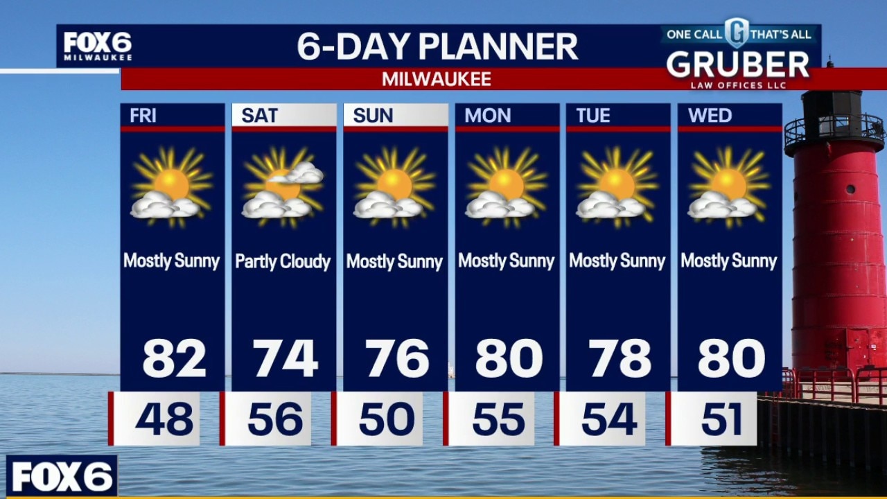
Mostly sunny and warmer on Wednesday. Highs will be in the low 80s inland to upper 70s near the lake. Partly sunny with slightly stronger winds and warmer temps on Thursday. Highs in the middle 80s. Storms are possible late Thursday night with better coverages Friday into Saturday.
Mostly sunny and warmer on Wednesday. Highs will be in the low 80s inland to upper 70s near the lake. Partly sunny with slightly stronger winds and warmer temps on Thursday. Highs in the middle 80s. Storms are possible late Thursday night with better coverages Friday into Saturday.
Weather Webcast with Chief Meteorologist Tom Wachs
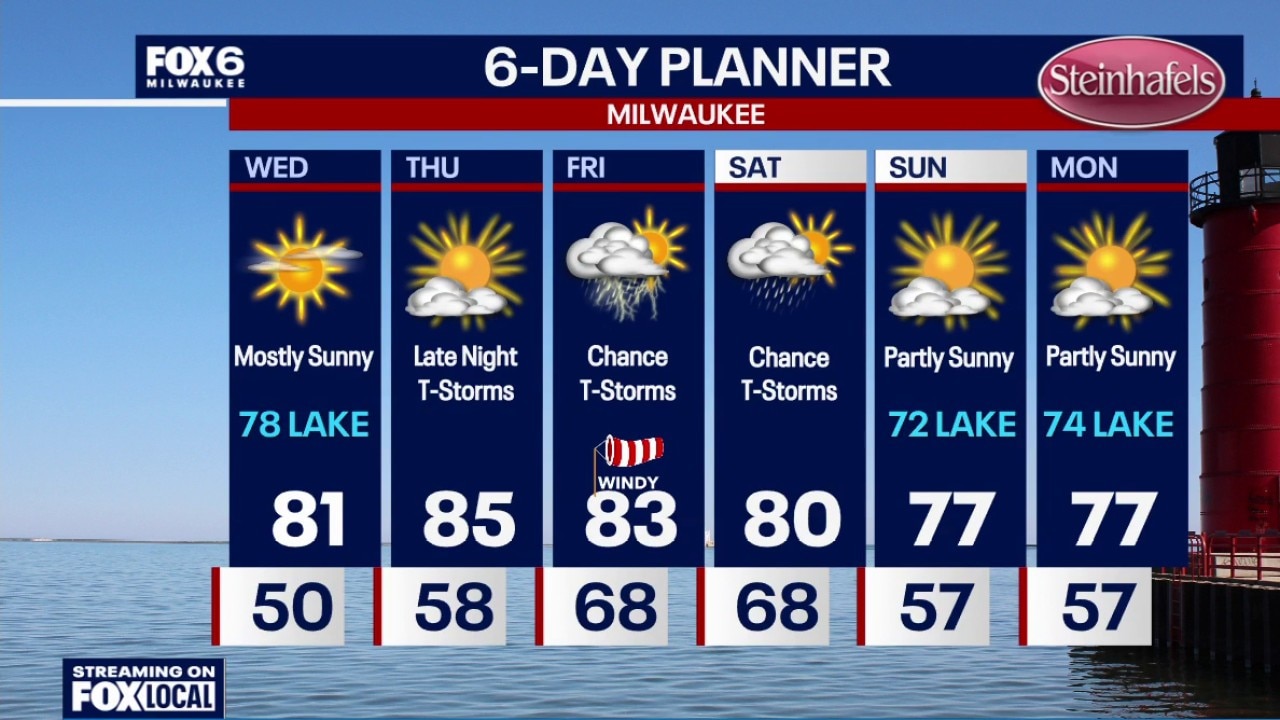
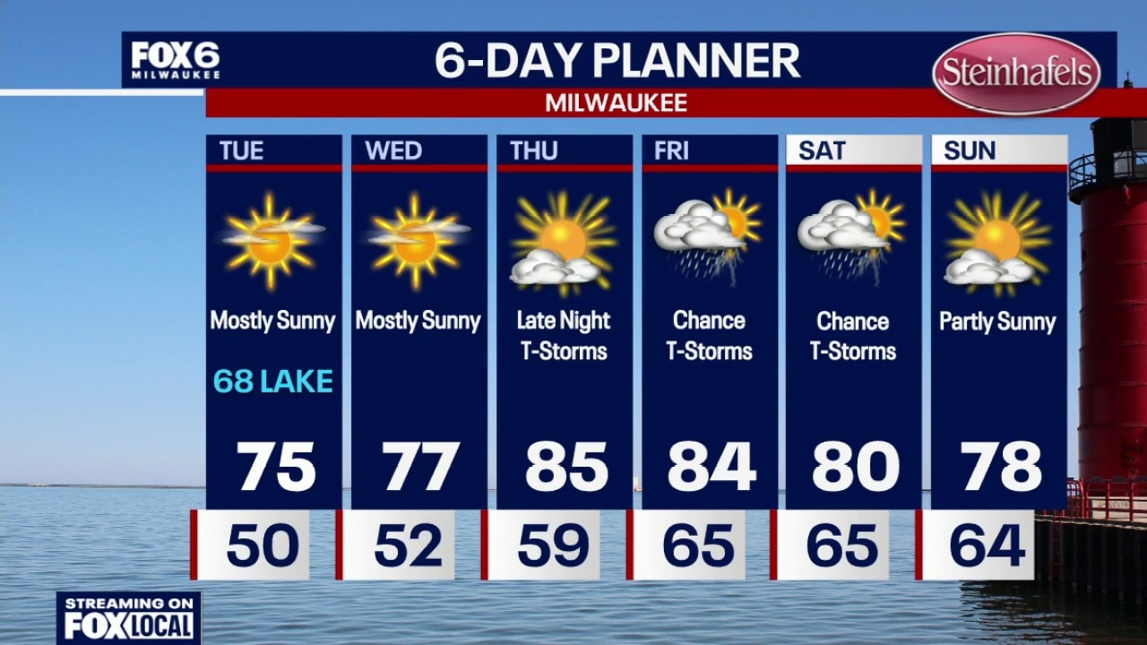
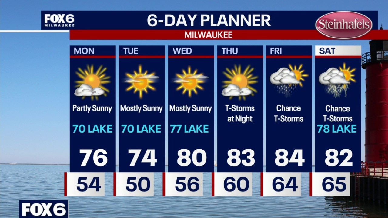
Clear skies overnight with temperatures settling in the 50s by sunrise. Mostly sunny and warmer on Wednesday with highs in the low 80s inland, upper 70s near the lake. Partly sunny, breezy and warm on Thursday with a high in the mid-80s (even near the lake). T-Storms are possible late Thursday night.
Clear skies overnight with temperatures settling in the 50s by sunrise. Mostly sunny and warmer on Wednesday with highs in the low 80s inland, upper 70s near the lake. Partly sunny, breezy and warm on Thursday with a high in the mid-80s (even near the lake). T-Storms are possible late Thursday night.
Weather Webcast with Chief Meteorologist Tom Wachs
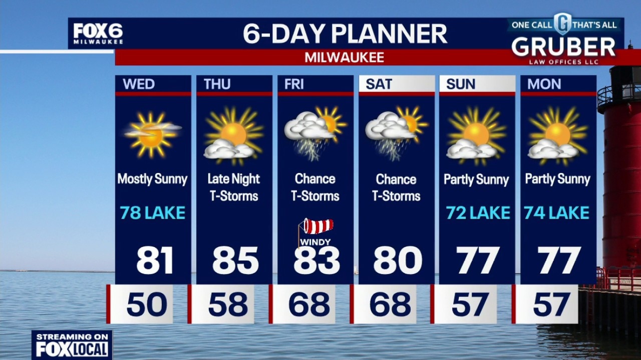
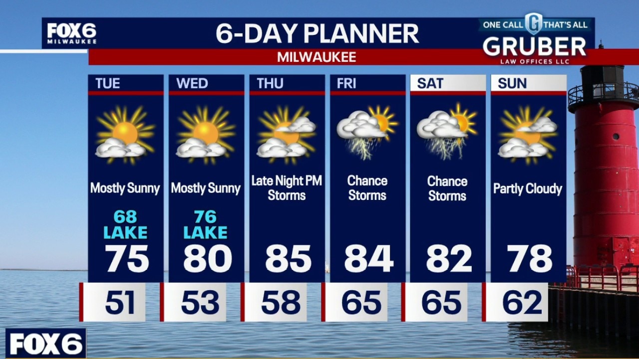
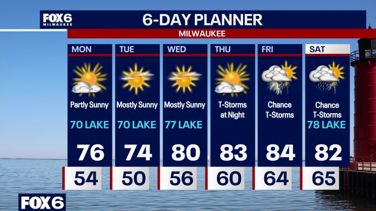
Clear skies tonight with temperatures dropping through the 60s and settling in the 50s overnight. Mostly sunny and warmer on Wednesday with highs in the low 80s inland, upper 70s near the lake.
Clear skies tonight with temperatures dropping through the 60s and settling in the 50s overnight. Mostly sunny and warmer on Wednesday with highs in the low 80s inland, upper 70s near the lake.
Weather webcast with Stephanie Barichello
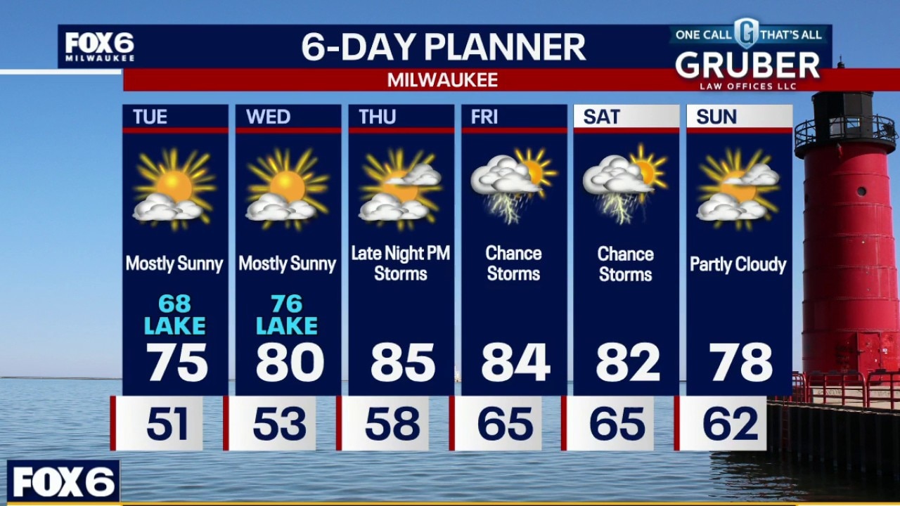
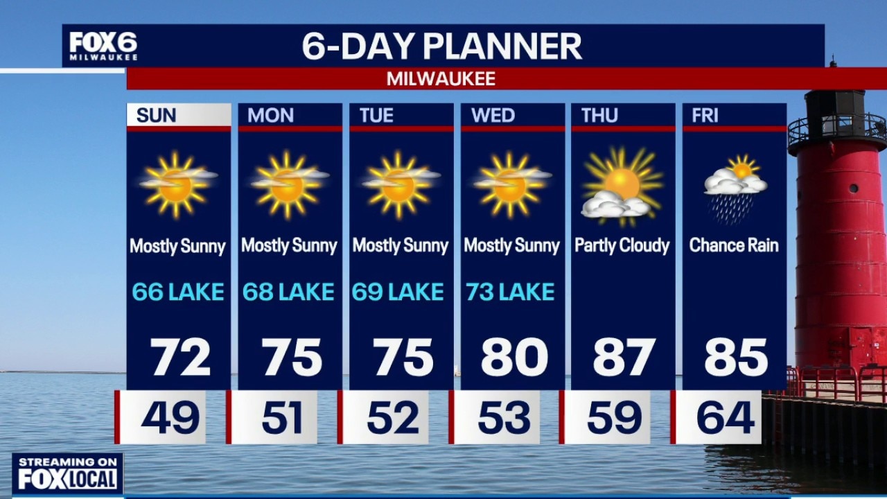
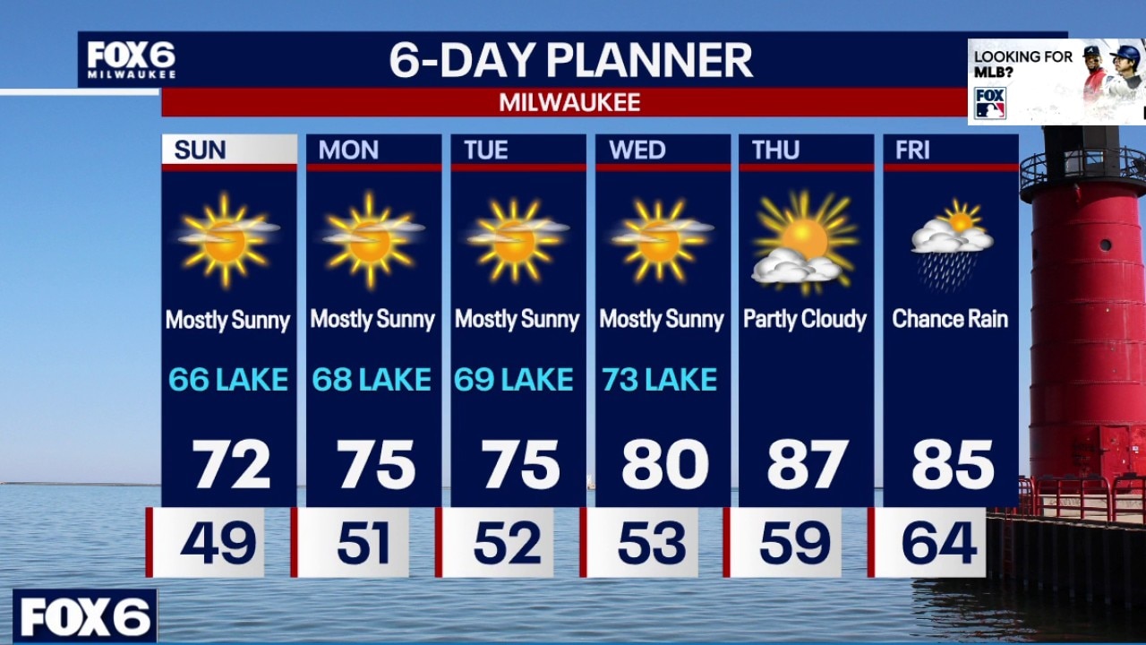
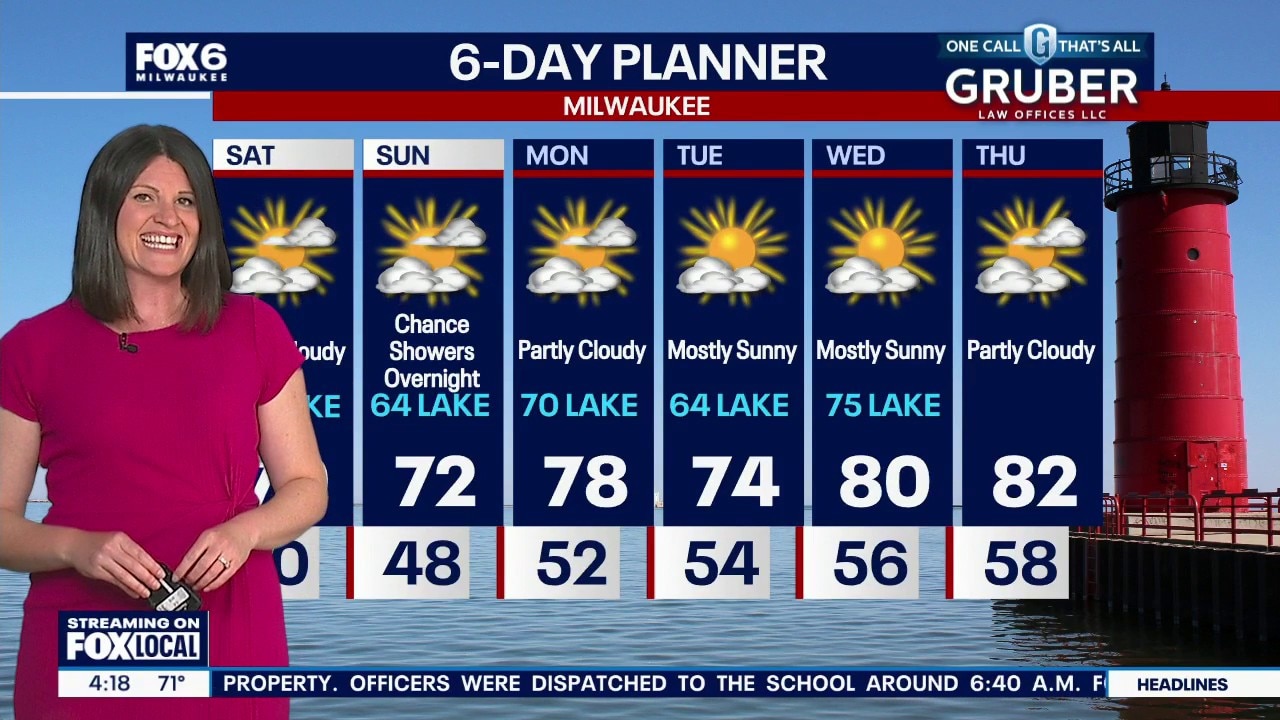
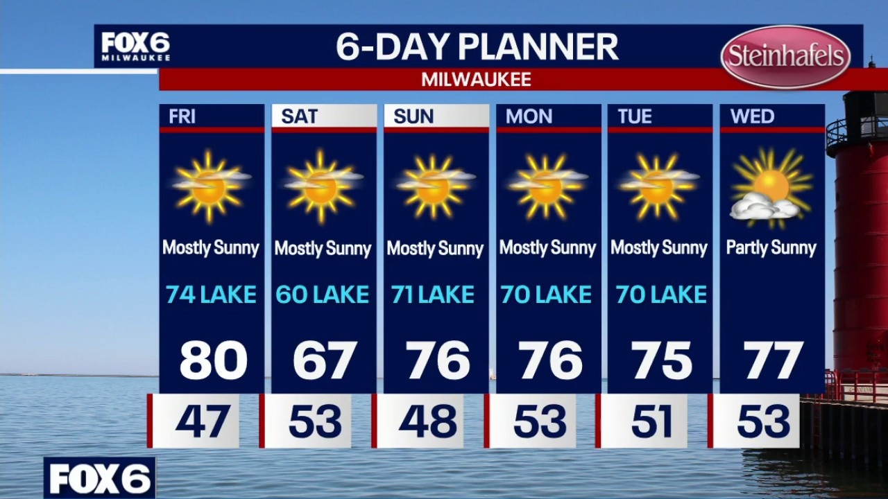
Mostly sunny Tuesday with highs in the mid-70s inland to the upper 60s near the lake. Mostly sunny and warmer on Wednesday with highs in the mid-to-upper 70s. Warm on Thursday with highs in the mid-80s with a southwest wind.
Mostly sunny Tuesday with highs in the mid-70s inland to the upper 60s near the lake. Mostly sunny and warmer on Wednesday with highs in the mid-to-upper 70s. Warm on Thursday with highs in the mid-80s with a southwest wind.
Weather webcast with Lisa Michaels
Mostly sunny Tuesday with highs in the mid-70s inland to the upper 60s near the lake. Mostly sunny and warmer on Wednesday with highs in the mid-to-upper 70s. Warm on Thursday with highs in the mid-80s with a southwest wind.
Mostly sunny Tuesday with highs in the mid-70s inland to the upper 60s near the lake. Mostly sunny and warmer on Wednesday with highs in the mid-to-upper 70s. Warm on Thursday with highs in the mid-80s with a southwest wind.
Weather Webcast with Chief Meteorologist Tom Wachs
Clearing skies overnight with temperatures settling around 50 by sunrise. Mostly sunny on Tuesday with a high in the mid-70s inland, upper 60s near the lake.
Clearing skies overnight with temperatures settling around 50 by sunrise. Mostly sunny on Tuesday with a high in the mid-70s inland, upper 60s near the lake.
Weather Webcast with Chief Meteorologist Tom Wachs
Clearing skies tonight with temperatures dropping through the 60s and settling around 50 by sunrise. Mostly sunny on Tuesday with a high in the mid-70s inland, upper 60s near the lake.
Clearing skies tonight with temperatures dropping through the 60s and settling around 50 by sunrise. Mostly sunny on Tuesday with a high in the mid-70s inland, upper 60s near the lake.
Weather webcast with Stephanie Barichello
Mostly cloudy on Monday morning then partly sunny on Monday afternoon. Highs in the mid-70s inland to upper 60s near the lake.
Mostly cloudy on Monday morning then partly sunny on Monday afternoon. Highs in the mid-70s inland to upper 60s near the lake.
Weather webcast with Lisa Michaels
Slight chance for a few showers early Monday morning. Most areas will remain dry. Lows in the low to mid 50s. Mostly cloudy on Monday morning then partly sunny on Monday afternoon. Highs in the mid-70s inland to upper 60s near the lake.
Slight chance for a few showers early Monday morning. Most areas will remain dry. Lows in the low to mid 50s. Mostly cloudy on Monday morning then partly sunny on Monday afternoon. Highs in the mid-70s inland to upper 60s near the lake.
Weather Webcast with Chief Meteorologist Tom Wachs
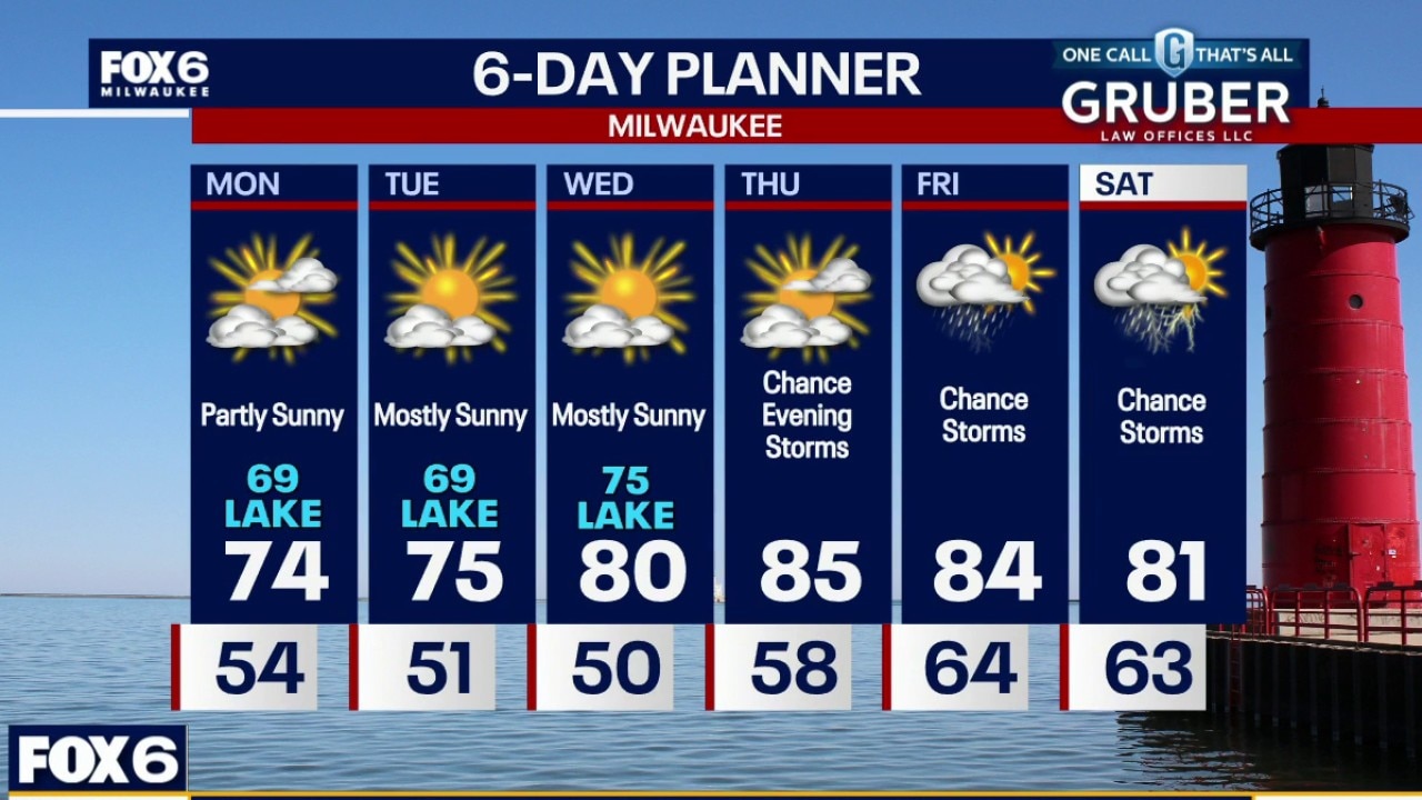
Mostly cloudy overnight with a slim chance for a light rain shower or two. Temperatures will settle in the 50s by sunrise. Mostly cloudy on Monday morning, partly sunny on Monday afternoon. Highs in the mid-70s inland, around 70 near the lake.
Mostly cloudy overnight with a slim chance for a light rain shower or two. Temperatures will settle in the 50s by sunrise. Mostly cloudy on Monday morning, partly sunny on Monday afternoon. Highs in the mid-70s inland, around 70 near the lake.
Weather Webcast with Chief Meteorologist Tom Wachs
Mostly cloudy tonight with a slim chance for a light rain shower this evening and overnight. Temperatures will drop through the 60s and settle in the 50s overnight. Mostly cloudy on Monday morning, partly sunny on Monday afternoon. Highs in the mid-70s inland, around 70 near the lake.
Mostly cloudy tonight with a slim chance for a light rain shower this evening and overnight. Temperatures will drop through the 60s and settle in the 50s overnight. Mostly cloudy on Monday morning, partly sunny on Monday afternoon. Highs in the mid-70s inland, around 70 near the lake.
Weather webcast with meteorologist Lisa Michaels
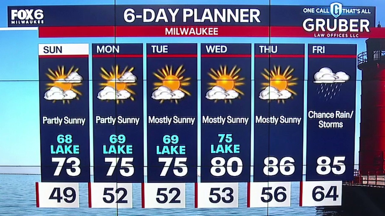
Partly sunny skies on Sunday with high temps in the lower 70s inland to upper 60s lakeside. Partly to mostly cloudy skies tonight. An isolated shower/drizzle is possible with a decaying line from the west.
Partly sunny skies on Sunday with high temps in the lower 70s inland to upper 60s lakeside. Partly to mostly cloudy skies tonight. An isolated shower/drizzle is possible with a decaying line from the west.
Weather Webcast with Holly Baker
Quiet conditions remain for the weekend into next week.
Quiet conditions remain for the weekend into next week.
Weather Webcast with Holly Baker
A summerlike pattern continues for the weekend into next week.
A summerlike pattern continues for the weekend into next week.
Weather webcast with meteorologist Lisa Michaels
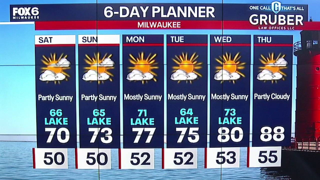
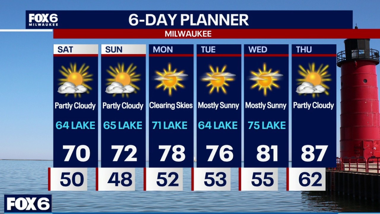
Partly sunny Saturday with highs in the low 70s inland to mid 60s near the lake. A swim risk for Ozaukee, Milwaukee, Racine, and Kenosha counties until Saturday night for dangerous swim conditions due to high waves and strong currents.
Partly sunny Saturday with highs in the low 70s inland to mid 60s near the lake. A swim risk for Ozaukee, Milwaukee, Racine, and Kenosha counties until Saturday night for dangerous swim conditions due to high waves and strong currents.
Weather Webcast with Holly Baker
A Happy Holly Forecast continues for the next 6 days.
A Happy Holly Forecast continues for the next 6 days.
Weather Webcast with Stephanie Barichello
More sunshine this weekend but a bit cooler, especially along Lake Michigan. Slight chance for showers late Sunday night, otherwise even more sunshine ahead next week.
More sunshine this weekend but a bit cooler, especially along Lake Michigan. Slight chance for showers late Sunday night, otherwise even more sunshine ahead next week.
Weather webcast with Stephanie Barichello
Southern Wisconsin is settling into a remarkably quiet weather pattern that should hold through at least the middle of next week. Inland areas will enjoy several days of warm temperatures, while regular lake breezes keep conditions noticeably cooler near Lake Michigan.
Southern Wisconsin is settling into a remarkably quiet weather pattern that should hold through at least the middle of next week. Inland areas will enjoy several days of warm temperatures, while regular lake breezes keep conditions noticeably cooler near Lake Michigan.
Weather webcast with Rob Haswell
Southern Wisconsin is settling into a remarkably quiet weather pattern that should hold through at least the middle of next week. Inland areas will enjoy several days of warm temperatures, while regular lake breezes keep conditions noticeably cooler near Lake Michigan.
Southern Wisconsin is settling into a remarkably quiet weather pattern that should hold through at least the middle of next week. Inland areas will enjoy several days of warm temperatures, while regular lake breezes keep conditions noticeably cooler near Lake Michigan.
Weather Webcast with Chief Meteorologist Tom Wachs
Mostly clear overnight with temperatures settling in the 40s. Mostly sunny on Friday with a high around 80 inland, 74 near the lake. Much cooler on Saturday with highs in the 60s.
Mostly clear overnight with temperatures settling in the 40s. Mostly sunny on Friday with a high around 80 inland, 74 near the lake. Much cooler on Saturday with highs in the 60s.