

Weather Webcast with Chief Meteorologist Tom Wachs
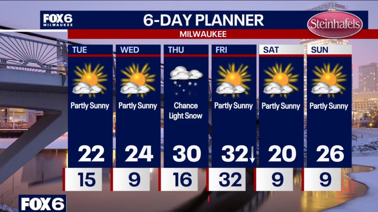
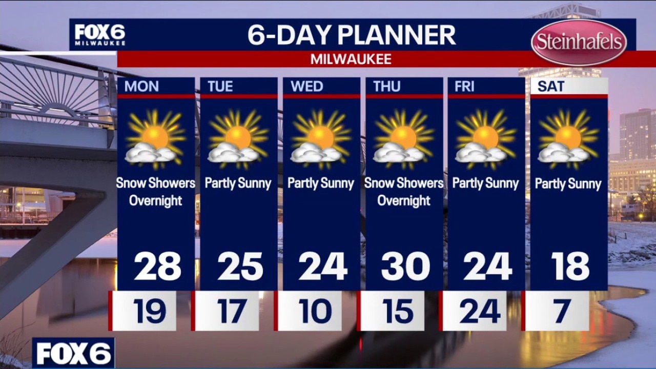
Becoming partly cloudy tonight with a few flurries possible overnight. Temperatures will drop through the 20s and settle in the teens overnight. Partly sunny and cooler on Tuesday with highs in the low 20s. We have some cold morning ahead. Single digits on Wednesday morning.
Becoming partly cloudy tonight with a few flurries possible overnight. Temperatures will drop through the 20s and settle in the teens overnight. Partly sunny and cooler on Tuesday with highs in the low 20s. We have some cold morning ahead. Single digits on Wednesday morning.
Weather Webcast with Chief Meteorologist Tom Wachs
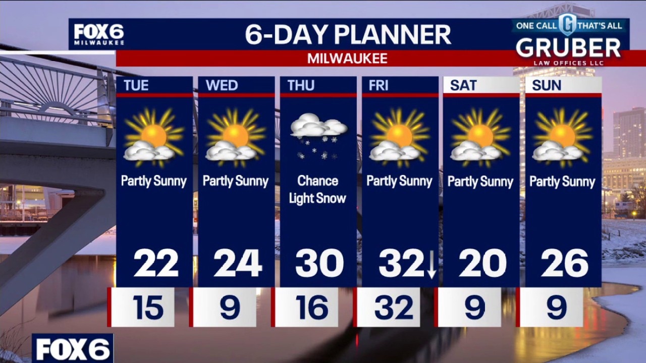
A few snow showers are possible overnight, otherwise temperatures will drop into the teens by sunrise. Partly sunny and cooler on Tuesday with highs in the low 20s.
A few snow showers are possible overnight, otherwise temperatures will drop into the teens by sunrise. Partly sunny and cooler on Tuesday with highs in the low 20s.
Weather webcast with Lisa Michaels
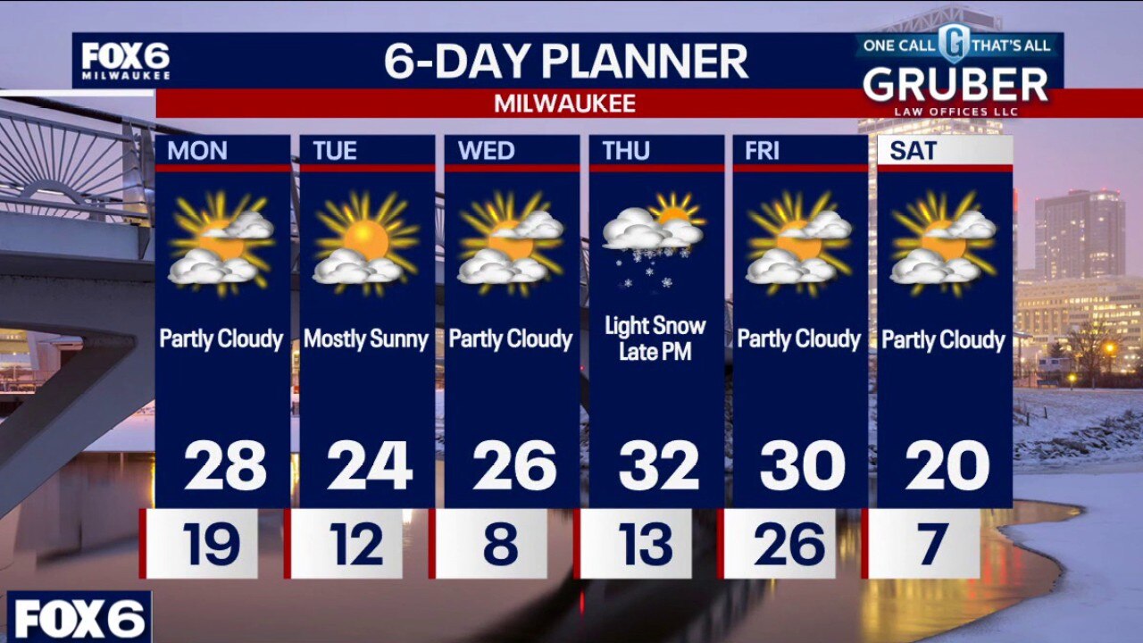
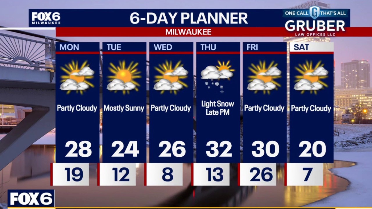
Southern Wisconsin starts the week under low clouds with patchy freezing drizzle or flurries early Monday, then turns dry with highs in the low to mid-20s.
Southern Wisconsin starts the week under low clouds with patchy freezing drizzle or flurries early Monday, then turns dry with highs in the low to mid-20s.
Weather webcast with Rob Haswell
Southern Wisconsin starts the week under low clouds with patchy freezing drizzle or flurries early Monday, then turns dry with highs in the low to mid-20s.
Southern Wisconsin starts the week under low clouds with patchy freezing drizzle or flurries early Monday, then turns dry with highs in the low to mid-20s.
Weather Webcast with Chief Meteorologist Tom Wachs
Light snow and freezing drizzle overnight. Becoming partly sunny on Monday with highs in the upper 20s.
Light snow and freezing drizzle overnight. Becoming partly sunny on Monday with highs in the upper 20s.
Weather webcast with Lisa Michaels
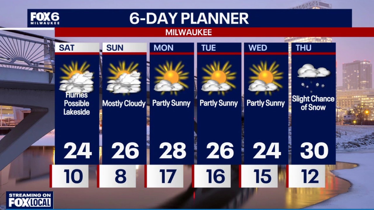
Cloudy morning with temperatures in the teens. Light snow near the lake is possible today- 1" possible. Highs on Saturday in the middle 20s. Skies will turn mostly clear Saturday night with temperatures falling into the single digits.
Cloudy morning with temperatures in the teens. Light snow near the lake is possible today- 1" possible. Highs on Saturday in the middle 20s. Skies will turn mostly clear Saturday night with temperatures falling into the single digits.
Weather Webcast with Stephanie Barichello
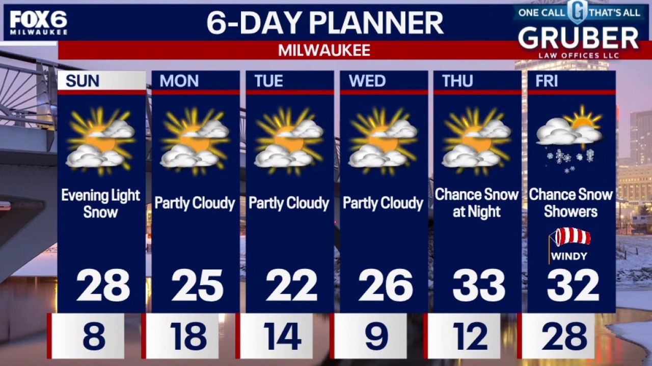
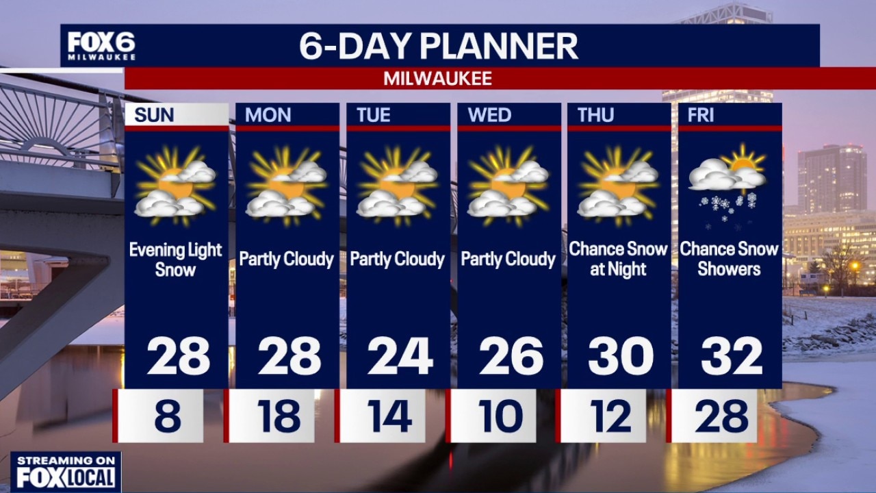
Clear tonight, then a chance for light snow Sunday evening with minimal accumulation. More 20s in the extended forecast. A chance for snow returns on Friday.
Clear tonight, then a chance for light snow Sunday evening with minimal accumulation. More 20s in the extended forecast. A chance for snow returns on Friday.
Weather webcast with Lisa Michaels
Cloudy morning with temperatures in the teens. Light snow near the lake is possible today- 1" possible. Highs on Saturday in the middle 20s.
Cloudy morning with temperatures in the teens. Light snow near the lake is possible today- 1" possible. Highs on Saturday in the middle 20s.
Weather Webcast with Holly Baker
Temperatures warm up to the 20s this weekend.
Temperatures warm up to the 20s this weekend.
Weather Webcast with Stephanie Barichello
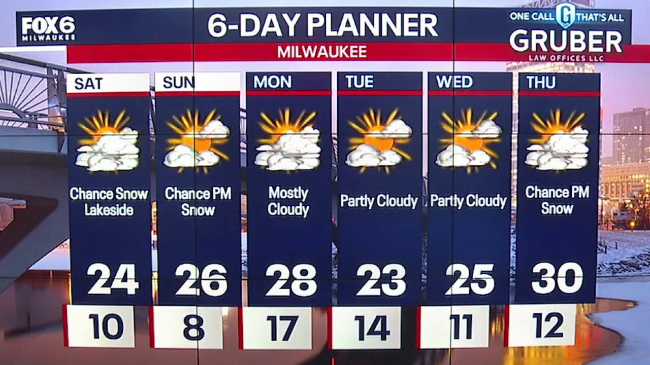
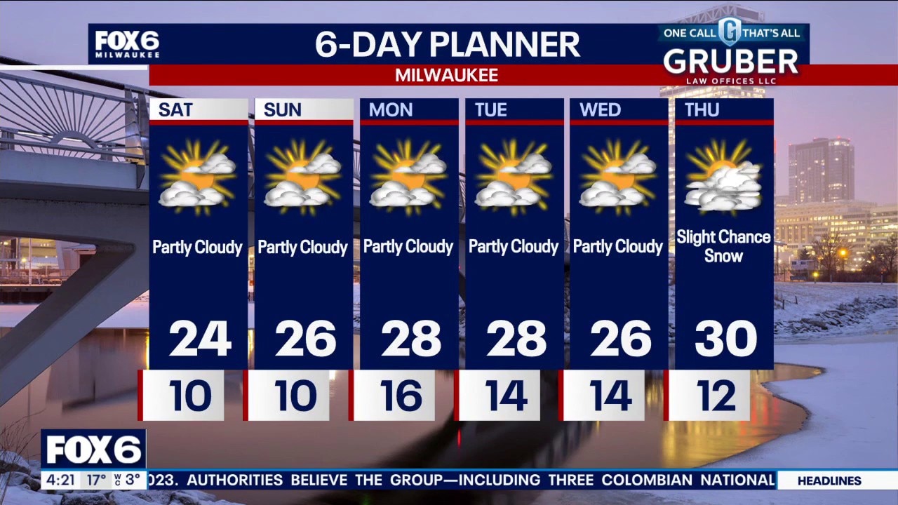
Done with lake-effect snow tonight! Warming into the 20s this weekend with some sunshine at times. There is a chance for light snow Sunday night. Temperatures remain in the 20s most of next week with another chance for snow by Thursday.
Done with lake-effect snow tonight! Warming into the 20s this weekend with some sunshine at times. There is a chance for light snow Sunday night. Temperatures remain in the 20s most of next week with another chance for snow by Thursday.
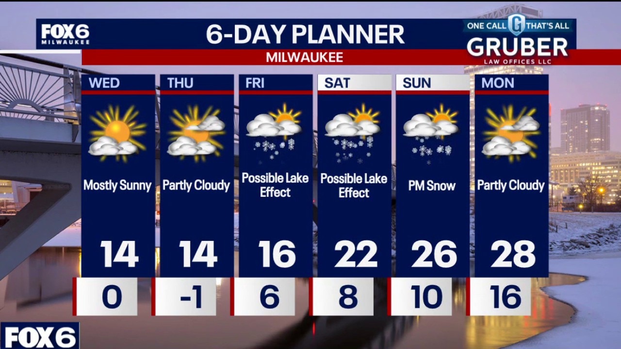
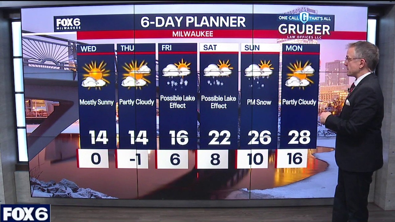
Weather webcast with Stephanie Barichello
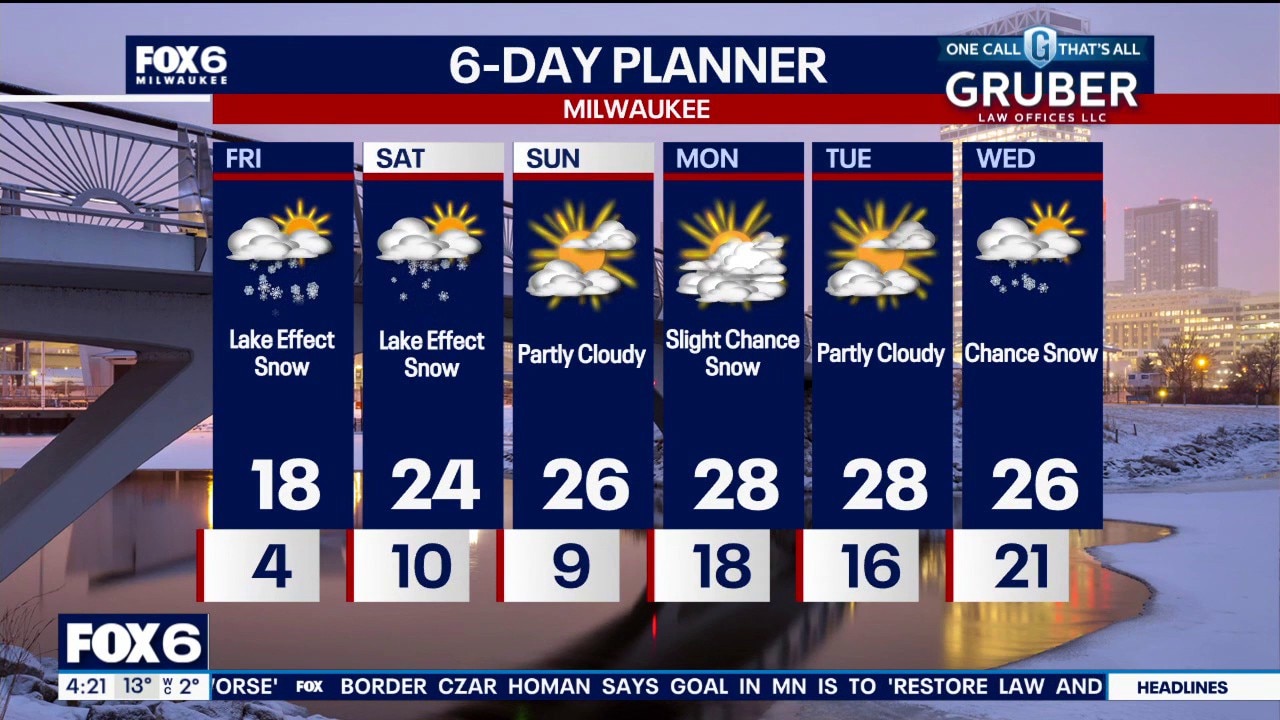
Cold conditions continue, with wind chills in the negative teens early Friday morning. Lake-effect snow is likely Friday, 1 to 2 inches are expected with localized higher totals if snow bands linger, while inland areas see lighter amounts.
Cold conditions continue, with wind chills in the negative teens early Friday morning. Lake-effect snow is likely Friday, 1 to 2 inches are expected with localized higher totals if snow bands linger, while inland areas see lighter amounts.
Weather webcast with Rob Haswell
Cold conditions continue, with wind chills in the negative teens early Friday morning. Lake-effect snow is likely Friday, 1 to 2 inches are expected with localized higher totals if snow bands linger, while inland areas see lighter amounts.
Cold conditions continue, with wind chills in the negative teens early Friday morning. Lake-effect snow is likely Friday, 1 to 2 inches are expected with localized higher totals if snow bands linger, while inland areas see lighter amounts.
Weather Webcast with Stephanie Barichello
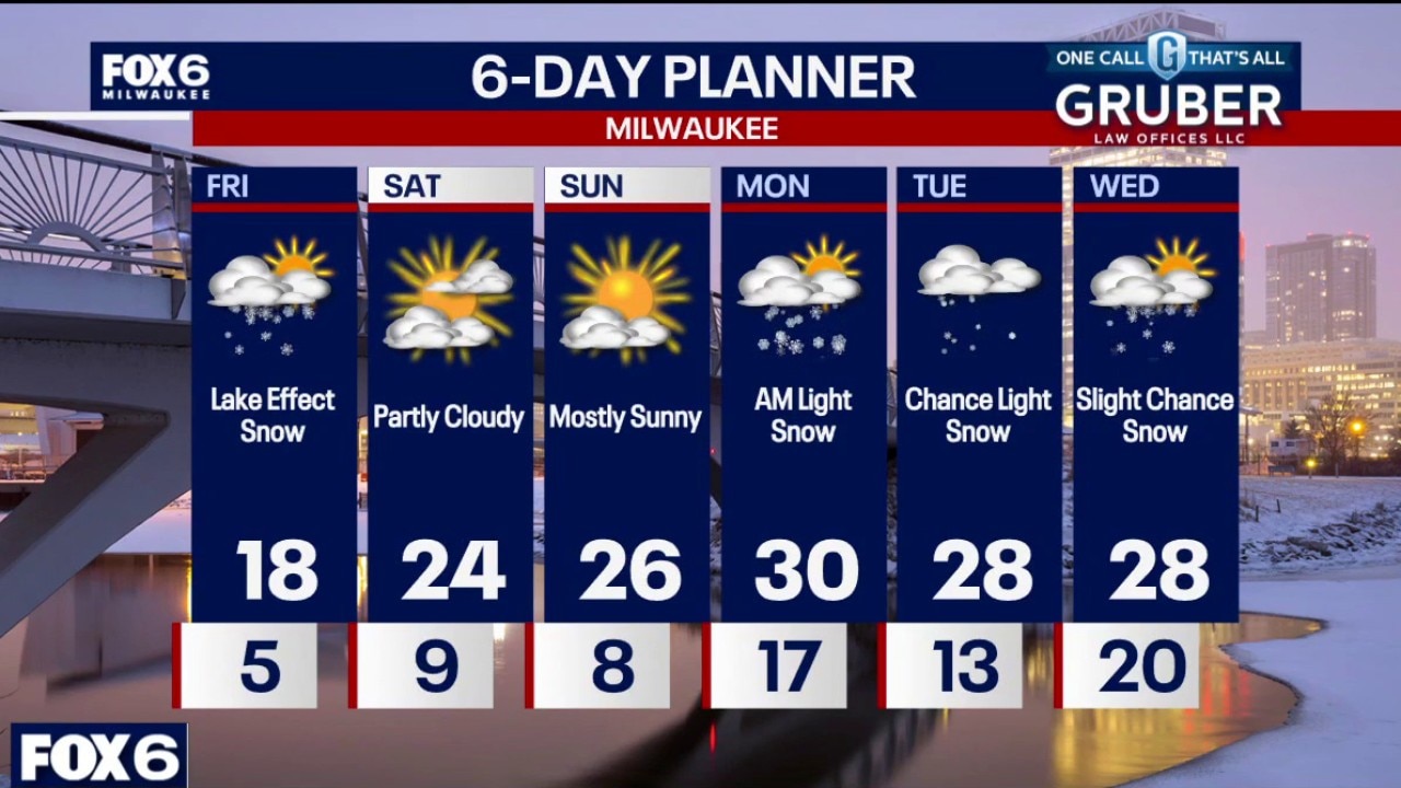
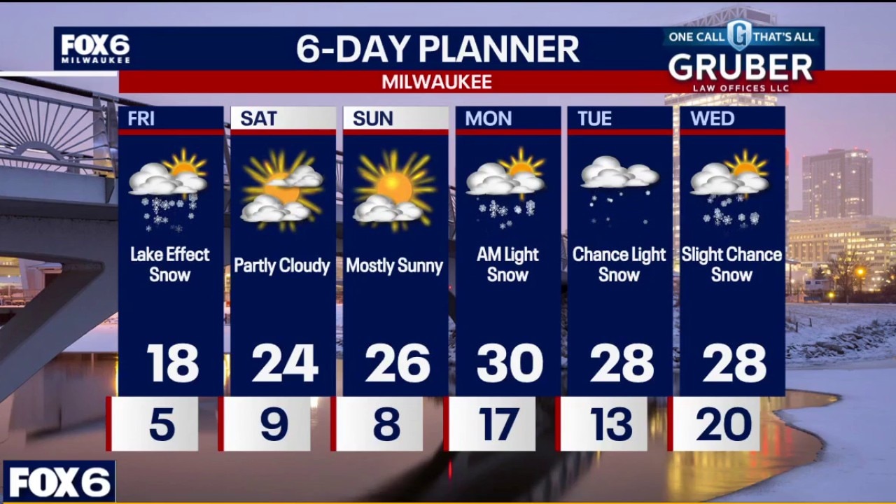
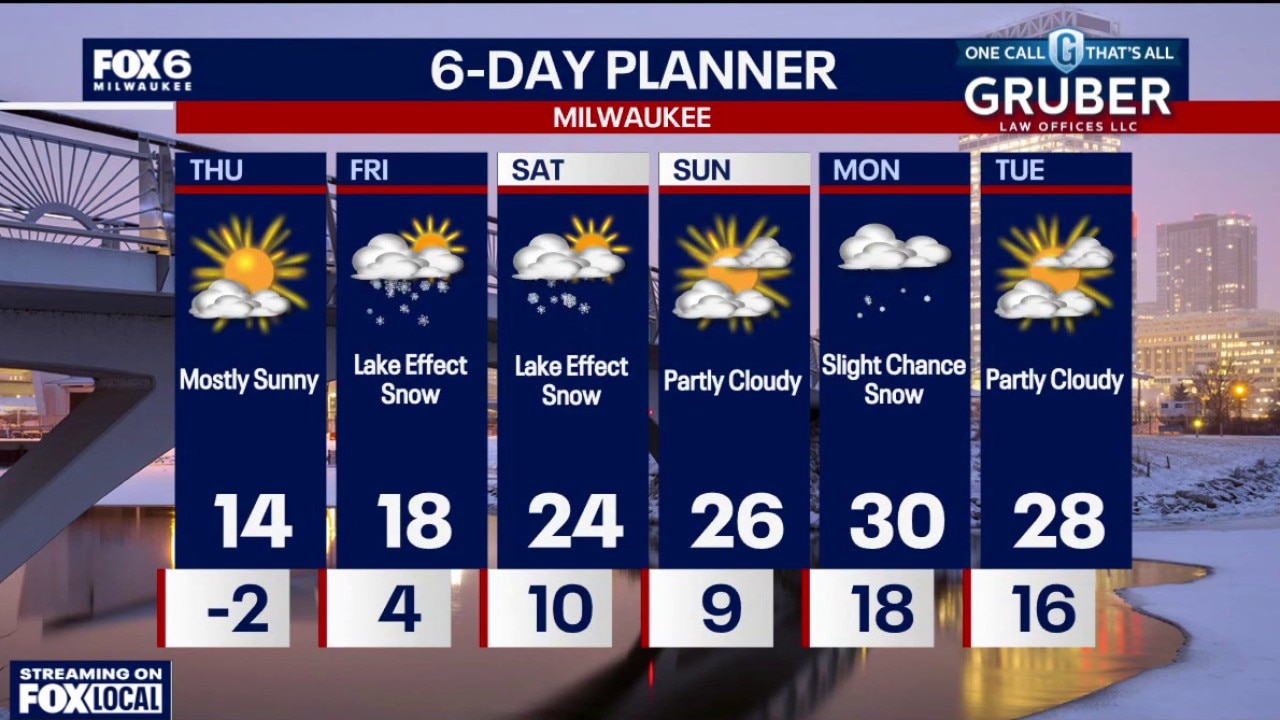
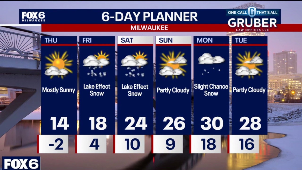
Lake effect snow returns Friday morning and lasts into the afternoon. It may move inland at times, but will primarily impact the southern lakeshore. 1-3" of accumulation possible along the lake, with highest totals from Milwaukee southward. It will be a dry, powdery snow. Warming into the 20s over the weekend and next week.
Lake effect snow returns Friday morning and lasts into the afternoon. It may move inland at times, but will primarily impact the southern lakeshore. 1-3" of accumulation possible along the lake, with highest totals from Milwaukee southward. It will be a dry, powdery snow. Warming into the 20s over the weekend and next week.
Weather webcast with Stephanie Barichello
Quiet but cold weather holds through Thursday, with overnight wind chills dipping into the negative teens. Attention then turns to lake-effect snow late Thursday night into Friday.
Quiet but cold weather holds through Thursday, with overnight wind chills dipping into the negative teens. Attention then turns to lake-effect snow late Thursday night into Friday.
Weather webcast with Rob Haswell
Quiet but cold weather holds through Thursday, with overnight wind chills dipping into the negative teens.
Quiet but cold weather holds through Thursday, with overnight wind chills dipping into the negative teens.
Weather Webcast with Holly Baker
Temperatures will be warmer by the weekend with a slight chance of lake effect snow on the way.
Temperatures will be warmer by the weekend with a slight chance of lake effect snow on the way.
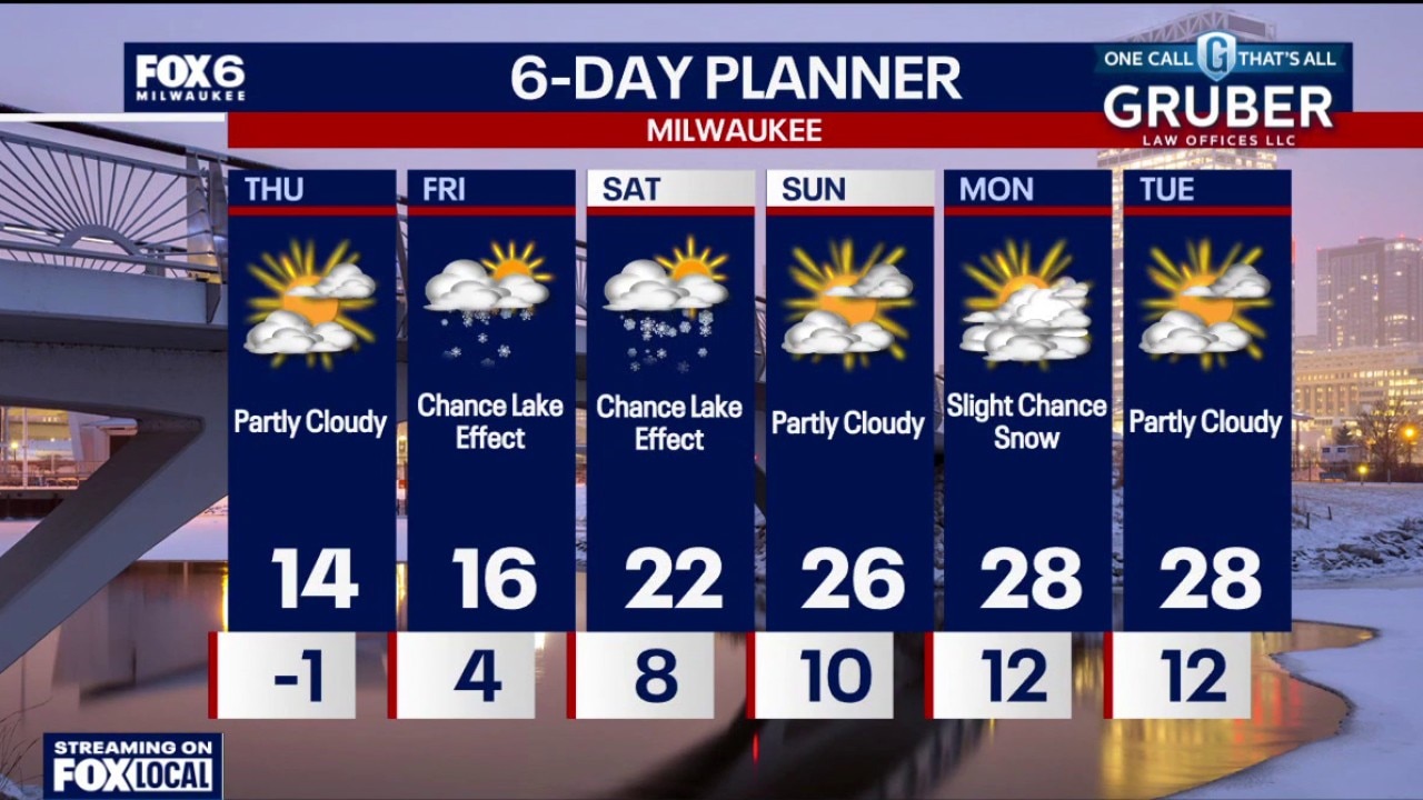
Weather Webcast with Stephanie Barichello
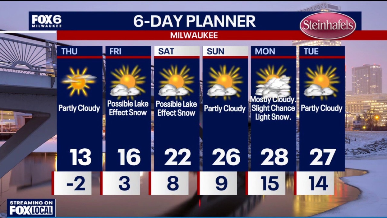
Another cold night ahead with air temperatures just below 0 and wind chills in the teens below 0. Lake effect looks more likely on Friday with at least a few inches of accumulation if it lasts through the afternoon. 20s expected through early next week.
Another cold night ahead with air temperatures just below 0 and wind chills in the teens below 0. Lake effect looks more likely on Friday with at least a few inches of accumulation if it lasts through the afternoon. 20s expected through early next week.
Weather webcast with Stephanie Barichello
Southern Wisconsin stays mostly dry and quiet through Thursday, but bitter cold continues with wind chills below zero at night. Highs today through Friday remain in the single digits to low teens.
Southern Wisconsin stays mostly dry and quiet through Thursday, but bitter cold continues with wind chills below zero at night. Highs today through Friday remain in the single digits to low teens.
Weather webcast with Rob Haswell
Southern Wisconsin stays mostly dry and quiet through Thursday, but bitter cold continues with wind chills below zero at night.
Southern Wisconsin stays mostly dry and quiet through Thursday, but bitter cold continues with wind chills below zero at night.
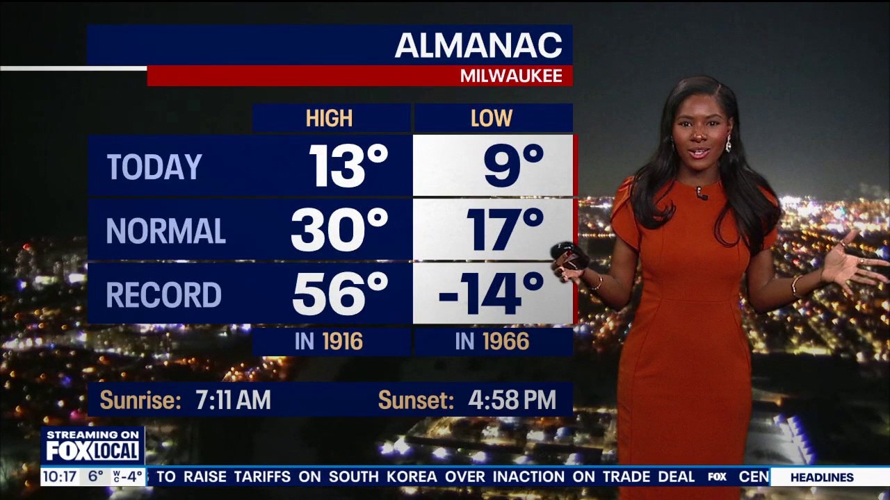
Weather webcast with Holly Baker
Cold air remains firmly in place through the work week, with highs in the upper single digits to teens and overnight lows near or below zero through Friday.
Cold air remains firmly in place through the work week, with highs in the upper single digits to teens and overnight lows near or below zero through Friday.