


Weather webcast with Rob Haswell
A Winter Storm Warning is in effect until 6am Saturday for all of SE WI. Very windy and cold today with highs only in the single digits and wind chills in the 20 to 30 below range. Blowing and drifting snow is likely today with very poor driving conditions in many areas. We stay cold for the weekend. We warm up by the middle of next week. Today: Blowing and drifting snow. Very windy and cold. Day wind chill: -20 to -25�
A Winter Storm Warning is in effect until 6am Saturday for all of SE WI. Very windy and cold today with highs only in the single digits and wind chills in the 20 to 30 below range. Blowing and drifting snow is likely today with very poor driving conditions in many areas. We stay cold for the weekend. We warm up by the middle of next week. Today: Blowing and drifting snow. Very windy and cold. Day wind chill: -20 to -25�

Weather Webcast with Meteorologist Eric Manges
FOX6 News at 6 offers the day's news, weather, and sports in southeast Wisconsin.
FOX6 News at 6 offers the day's news, weather, and sports in southeast Wisconsin.

Weather Webcast with Meteorologist Stephanie Barichello
Snow will wind down later tonight with 2-5" possible across the area. Blowing snow and dangerous cold tonight and throughout the day tomorrow. Staying cold through Christmas Day.
Snow will wind down later tonight with 2-5" possible across the area. Blowing snow and dangerous cold tonight and throughout the day tomorrow. Staying cold through Christmas Day.
Weather webcast with Rob Haswell
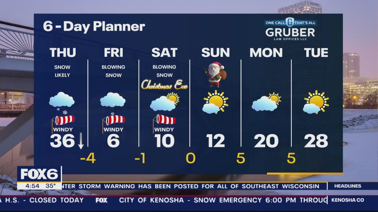
Winter Storm Warning 9am Thursday to 6am Saturday for All of SE Wisconsin. We start our day on a mild note but the passing cold front drops us into the teens and low 20s this afternoon and into the sub-zero range overnight. Light snow this morning becoming heavier this afternoon and tonight. Wind speeds intensify behind the front with gusts 40-55mph at times from this afternoon through Saturday morning.
Winter Storm Warning 9am Thursday to 6am Saturday for All of SE Wisconsin. We start our day on a mild note but the passing cold front drops us into the teens and low 20s this afternoon and into the sub-zero range overnight. Light snow this morning becoming heavier this afternoon and tonight. Wind speeds intensify behind the front with gusts 40-55mph at times from this afternoon through Saturday morning.

Weather Webcast with Tom Wachs
Snow picks up inland overnight and really picks up in Milwaukee by late morning/midday Thursday. The worst of the wind/snow will be late morning through mid-evening on Thursday in Milwaukee.
Snow picks up inland overnight and really picks up in Milwaukee by late morning/midday Thursday. The worst of the wind/snow will be late morning through mid-evening on Thursday in Milwaukee.

Weather Webcast with Meteorologist Stephanie Barichello
Quiet today, then snow arrives later tonight and continues much of Thursday. Although snowfall totals are down to about 3-6" for most, it'll still be dicey at times Thursday. Blowing/drifting snow remains a concern Thursday night into Friday morning as wind gusts of 44-55mph are expected. It'll also be VERY cold with subzero wind chills Thursday afternoon through Sunday.
Quiet today, then snow arrives later tonight and continues much of Thursday. Although snowfall totals are down to about 3-6" for most, it'll still be dicey at times Thursday. Blowing/drifting snow remains a concern Thursday night into Friday morning as wind gusts of 44-55mph are expected. It'll also be VERY cold with subzero wind chills Thursday afternoon through Sunday.

Weather webcast with Stephanie Barichello
Bitterly cold and clear to start our day today with single digit and some subzero reading by dawn. We do warm later today and tonight to get to near 30 by midnight. We should stay dry today but snow starts overnight and becomes heavy by Thursday. Winter Weather Advisory begins at 9am Thursday with a Winter Storm Watch going into effect at 6pm on Thursday and lasting into Saturday morning. Several inches of snow along with very strong wind gusts will cause blizzard conditions at times from later Thursday into Friday. We stay wind and very cold Friday and through the weekend.
Bitterly cold and clear to start our day today with single digit and some subzero reading by dawn. We do warm later today and tonight to get to near 30 by midnight. We should stay dry today but snow starts overnight and becomes heavy by Thursday. Winter Weather Advisory begins at 9am Thursday with a Winter Storm Watch going into effect at 6pm on Thursday and lasting into Saturday morning. Several inches of snow along with very strong wind gusts will cause blizzard conditions at times from later Thursday into Friday. We stay wind and very cold Friday and through the weekend.

Weather webcast with Rob Haswell
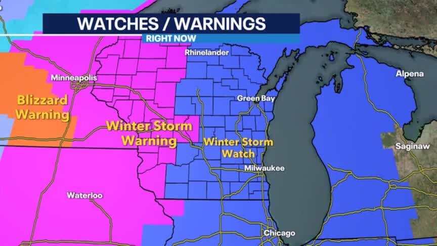
Bitterly cold and clear to start our day today with single digit and some subzero reading by dawn. We do warm later today and tonight to get to near 30 by midnight. We should stay dry today but snow starts overnight and becomes heavy by Thursday. Winter Weather Advisory begins at 9am Thursday with a Winter Storm Watch going into effect at 6pm on Thursday and lasting into Saturday morning.
Bitterly cold and clear to start our day today with single digit and some subzero reading by dawn. We do warm later today and tonight to get to near 30 by midnight. We should stay dry today but snow starts overnight and becomes heavy by Thursday. Winter Weather Advisory begins at 9am Thursday with a Winter Storm Watch going into effect at 6pm on Thursday and lasting into Saturday morning.
Weather Webcast with Tom Wachs
Cold overnight with temperatures in the single digits. Dry on Wednesday with highs in the 20s. Snow on Thursday with 4-8" of accumulation. Very strong winds & brutally cold air late Thursday night into Friday.
Cold overnight with temperatures in the single digits. Dry on Wednesday with highs in the 20s. Snow on Thursday with 4-8" of accumulation. Very strong winds & brutally cold air late Thursday night into Friday.
Weather Webcast with Tom Wachs
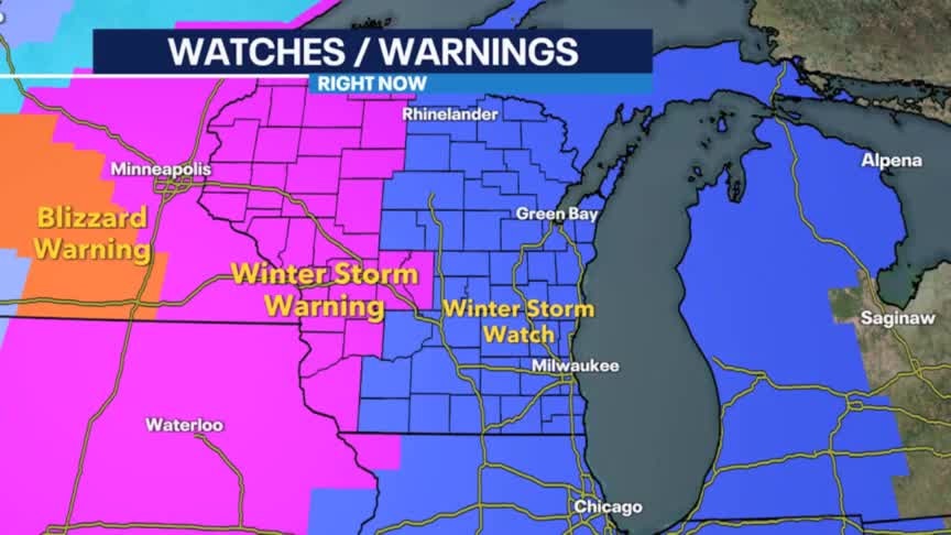
Cold tonight with temperatures dropping into the single digits overnight. Mostly cloudy on Wednesday with light snow possible late Wednesday night. A major winter storm will impact SE WI Thursday night into Friday.
Cold tonight with temperatures dropping into the single digits overnight. Mostly cloudy on Wednesday with light snow possible late Wednesday night. A major winter storm will impact SE WI Thursday night into Friday.

Weather Webcast with Meteorologist Stephanie Barichello
Falling temperatures this afternoon with single digit lows tonight. Increasing clouds Wednesday with light snow by evening. Snowy, windy and cold Thursday and Friday. Blowing/drifting possible over the weekend and VERY cold.
Falling temperatures this afternoon with single digit lows tonight. Increasing clouds Wednesday with light snow by evening. Snowy, windy and cold Thursday and Friday. Blowing/drifting possible over the weekend and VERY cold.

Weather webcast with Rob Haswell
Ahead of a cold front today we will briefly get to near 30 but then temperatures fall into the 20s this afternoon and single digits overnight. We will see a few morning snow showers but then clear up to some sunshine this afternoon. Wednesday marks the Winter Solstice and arrives with some sun and highs in the low 30s.
Ahead of a cold front today we will briefly get to near 30 but then temperatures fall into the 20s this afternoon and single digits overnight. We will see a few morning snow showers but then clear up to some sunshine this afternoon. Wednesday marks the Winter Solstice and arrives with some sun and highs in the low 30s.
Weather Webcast with Tom Wachs
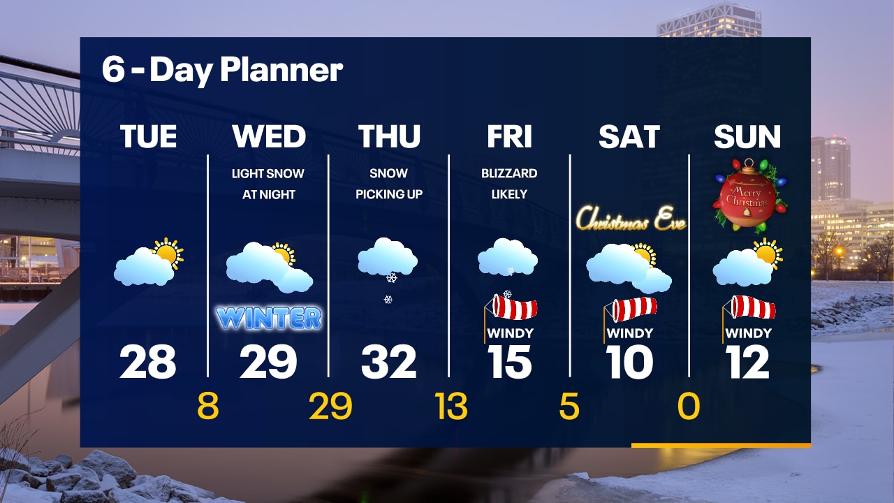
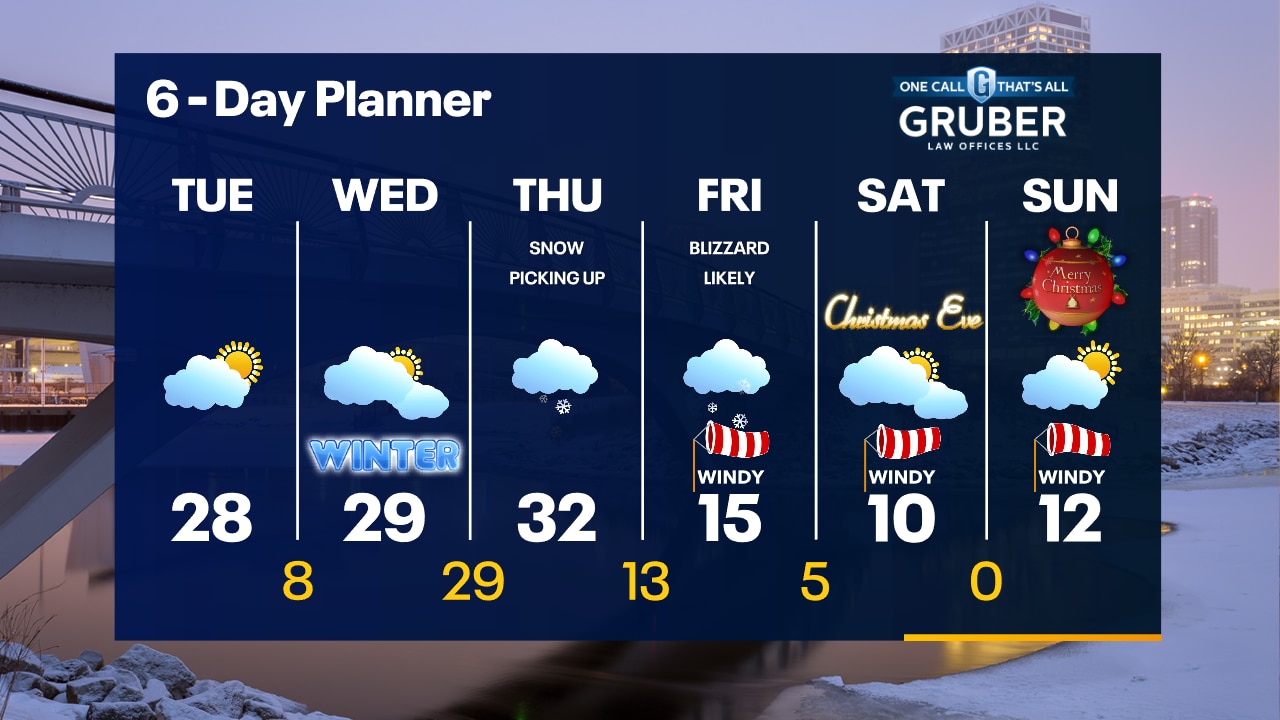
Light snow overnight with a dusting possible. Sun returns on Tuesday with highs in the 20s. A blizzard is expected Thursday night and Friday.
Light snow overnight with a dusting possible. Sun returns on Tuesday with highs in the 20s. A blizzard is expected Thursday night and Friday.
Weather Webcast with Tom Wachs
Winter Storm Watches late this week as a blizzard is likely Thursday night into Friday. Stay tuned for updates.
Winter Storm Watches late this week as a blizzard is likely Thursday night into Friday. Stay tuned for updates.

Weather Webcast with Meteorologist Stephanie Barichello
Light snow tonight with up to 1" possible by morning, then cold in the days ahead. Bigger late week storm Wednesday night to Friday night could bring blizzard conditions and high snowfall totals. Stay tuned.
Light snow tonight with up to 1" possible by morning, then cold in the days ahead. Bigger late week storm Wednesday night to Friday night could bring blizzard conditions and high snowfall totals. Stay tuned.

Weather webcast with Rob Haswell
High pressure is in charge of our forecast giving us some sunshine but we can also expect a few snow showers. Highs will be in the low to mid 20s today. A low arrives tomorrow and slightly boosts temperatures while bringing another round of snow showers. A much stronger low is expected by Thursday and into Friday. This system has the potential to bring significant snow and very strong wind gusts.
High pressure is in charge of our forecast giving us some sunshine but we can also expect a few snow showers. Highs will be in the low to mid 20s today. A low arrives tomorrow and slightly boosts temperatures while bringing another round of snow showers. A much stronger low is expected by Thursday and into Friday. This system has the potential to bring significant snow and very strong wind gusts.

Weather Webcast with Tom Wachs
Clear and cold overnight with wind chills below zero. Increasing clouds on Monday with a chance for snow at night. Highs in the 20s.
Clear and cold overnight with wind chills below zero. Increasing clouds on Monday with a chance for snow at night. Highs in the 20s.

Weather Webcast with Tom Wachs
Cold tonight with temperatures in the single digits to around 10 by sunrise. Increasing clouds on Monday with a high in the mid-20s. Light snow showers Monday night.
Cold tonight with temperatures in the single digits to around 10 by sunrise. Increasing clouds on Monday with a high in the mid-20s. Light snow showers Monday night.

Weather Webcast with Meteorologist Stephanie Barichello
A cold and blustery day today but we should see a few peeks of sunshine at times! A quick round of light snow Monday night then a bigger storm by the end of the week.
A cold and blustery day today but we should see a few peeks of sunshine at times! A quick round of light snow Monday night then a bigger storm by the end of the week.
Weather Webcast with Meteorologist Stephanie Barichello
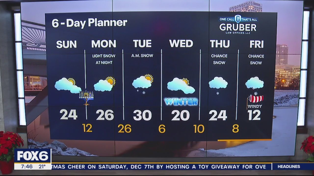
Peeks of sunshine return today but it'll be blustery and cold with air temperatures in the 20s, wind chills in the single digits. Temperatures fall into the teens tonight then mid 20s Monday. There is a chance for light snow Monday night into Tuesday morning, then potentially a bigger system Wednesday night through Friday. That system will usher in the coldest air of the season for the start to the holiday weekend.
Peeks of sunshine return today but it'll be blustery and cold with air temperatures in the 20s, wind chills in the single digits. Temperatures fall into the teens tonight then mid 20s Monday. There is a chance for light snow Monday night into Tuesday morning, then potentially a bigger system Wednesday night through Friday. That system will usher in the coldest air of the season for the start to the holiday weekend.