

Weather Webcast With Lisa Michaels
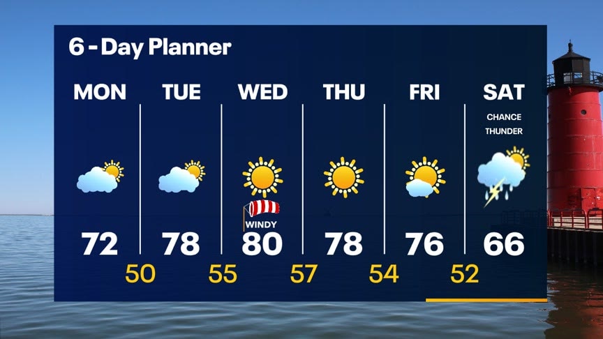
Mostly clear and mild tonight. Temperatures dropping through the 60s and into the 50s overnight. Another warm day Tuesday with highs in the upper 70s and breezy southwest wind. Partly sunny skies in the forecast. Highs around 80 mid-week with a strong southwest wind. We could break a long-standing record high on Thursday. Still warm on Friday before a cold front moves on Saturday. This front will increase our chances for t-storms Saturday. Rain/snow showers possible Sunday.
Mostly clear and mild tonight. Temperatures dropping through the 60s and into the 50s overnight. Another warm day Tuesday with highs in the upper 70s and breezy southwest wind. Partly sunny skies in the forecast. Highs around 80 mid-week with a strong southwest wind. We could break a long-standing record high on Thursday. Still warm on Friday before a cold front moves on Saturday. This front will increase our chances for t-storms Saturday. Rain/snow showers possible Sunday.

Weather Webcast with Meteorologist Rob Haswell
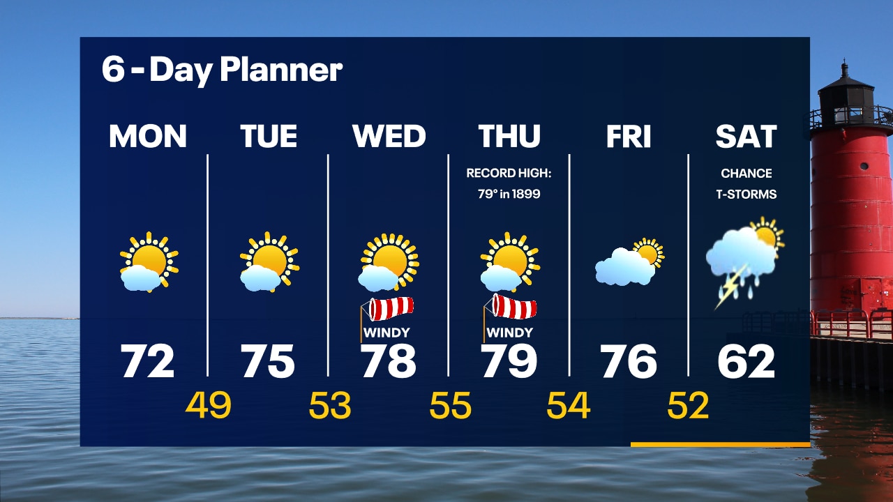
A persistent blocking pattern will dominate our forecast for several days giving us a stretch of calm and warm weather. Highs today will be in the low 70s today and upper 70s to near 80 Tuesday and Wednesday.
A persistent blocking pattern will dominate our forecast for several days giving us a stretch of calm and warm weather. Highs today will be in the low 70s today and upper 70s to near 80 Tuesday and Wednesday.
Weather Webcast with Tom Wachs
Partly cloudy and mild overnight with temperatures in the 40s. Partly sunny, breezy and warm on Monday with highs in the low 70s. Cooling along the lakeshore later in the afternoon.
Partly cloudy and mild overnight with temperatures in the 40s. Partly sunny, breezy and warm on Monday with highs in the low 70s. Cooling along the lakeshore later in the afternoon.

Weather Webcast with Tom Wachs
Partly cloudy tonight with temperatures dropping through the 50s this evening and into the 40s overnight. Mostly sunny and warm on Monday with highs in the low 70s. Cooling right along the lake in the afternoon.
Partly cloudy tonight with temperatures dropping through the 50s this evening and into the 40s overnight. Mostly sunny and warm on Monday with highs in the low 70s. Cooling right along the lake in the afternoon.
Weather Webcast with Meteorologist Lisa Michaels
Clear and sunny start to Sunday. High temperatures will be in the upper 60s this afternoon. Lakeside closer to the mid 50s.
Clear and sunny start to Sunday. High temperatures will be in the upper 60s this afternoon. Lakeside closer to the mid 50s.
Weather Webcast with Meteorologist Eric Manges
70s will be back soon and will stick around just about all week
70s will be back soon and will stick around just about all week

Weather Webcast with Meteorologist Eric Manges
Hope you're ready for the 70s next week because there will be a whole lot of it!
Hope you're ready for the 70s next week because there will be a whole lot of it!
Weather Webcast with Meteorologist Lisa Michaels
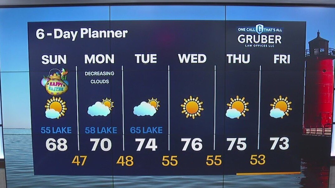
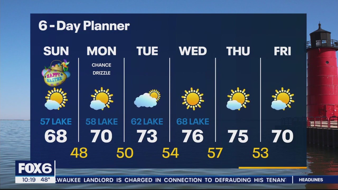
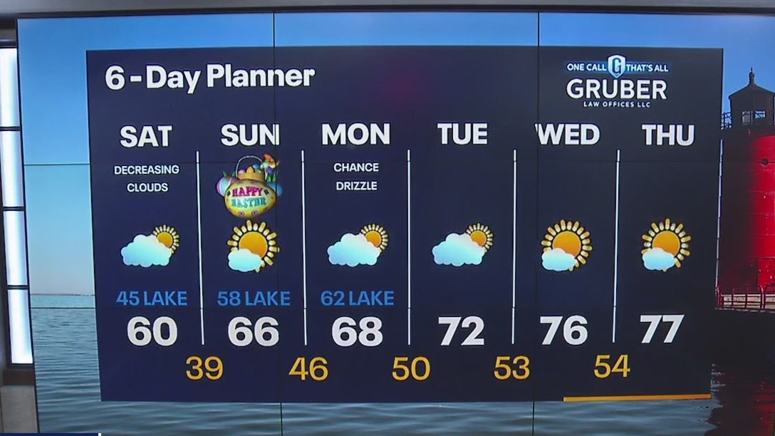
Slight chance light snow in northern counties this morning. Clouds will gradually decrease today with highs reaching near 60F. Easter Sunday will be mostly sunny with highs continuing to climb in the mid 60s.
Slight chance light snow in northern counties this morning. Clouds will gradually decrease today with highs reaching near 60F. Easter Sunday will be mostly sunny with highs continuing to climb in the mid 60s.
Weather Webcast with Meteorologist Eric Manges
Warmer weather becomes the norm especially by next week!
Warmer weather becomes the norm especially by next week!

Weather webcast with Rob Haswell
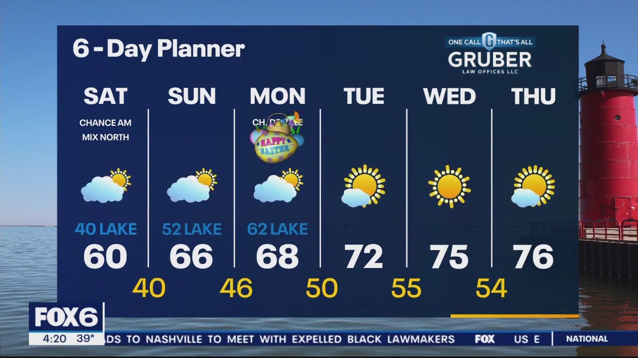
High pressure builds across the area today and for the next few days, keeping us mostly calm and clear. Temperatures will vary widely today with highs in the upper 30s to low 40s near Lake Michigan and upper 40s to low 50s well inland. A slight disturbance may generate some light snow or a wintry mix overnight tonight in our far north counties - north of HWY 33. We stay mostly sunny through the Easter and Passover weekend with warming temperatures. Highs will be in the 60s and warm well into the 70s by next week.
High pressure builds across the area today and for the next few days, keeping us mostly calm and clear. Temperatures will vary widely today with highs in the upper 30s to low 40s near Lake Michigan and upper 40s to low 50s well inland. A slight disturbance may generate some light snow or a wintry mix overnight tonight in our far north counties - north of HWY 33. We stay mostly sunny through the Easter and Passover weekend with warming temperatures. Highs will be in the 60s and warm well into the 70s by next week.

Weather Webcast with Tom Wachs
Clear skies overnight with temperatures in the upper 20s to low 30s by sunrise. Partly sunny and cooler on Friday with highs around 40 near the lake, upper 40s to around 50 far inland.
Clear skies overnight with temperatures in the upper 20s to low 30s by sunrise. Partly sunny and cooler on Friday with highs around 40 near the lake, upper 40s to around 50 far inland.

Weather Webcast with Tom Wachs
The wind will die down tonight with temperatures dropping into the upper 20s to low 30s by sunrise. Partly sunny and cooler on Friday. Highs only around 40 near the lake. Warming up this weekend.
The wind will die down tonight with temperatures dropping into the upper 20s to low 30s by sunrise. Partly sunny and cooler on Friday. Highs only around 40 near the lake. Warming up this weekend.
Weather Webcast with Meteorologist Eric Manges
Plenty of sunshine into the weekend but staying cooler. Warmer temps can be expected by mid-April!
Plenty of sunshine into the weekend but staying cooler. Warmer temps can be expected by mid-April!

Weather webcast with Eric Manges
Sunny and seasonable today with highs getting near 50 and a breezy west wind. Cooler Friday but it doesn't last long as by Saturday we're back to the 50s. A warming trend continues to Sunday and Monday with highs into the 60s. Long term we look dry and warmer than average meaning plenty of 70s will be possible into mid-April.
Sunny and seasonable today with highs getting near 50 and a breezy west wind. Cooler Friday but it doesn't last long as by Saturday we're back to the 50s. A warming trend continues to Sunday and Monday with highs into the 60s. Long term we look dry and warmer than average meaning plenty of 70s will be possible into mid-April.
Weather Webcast with Tom Wachs
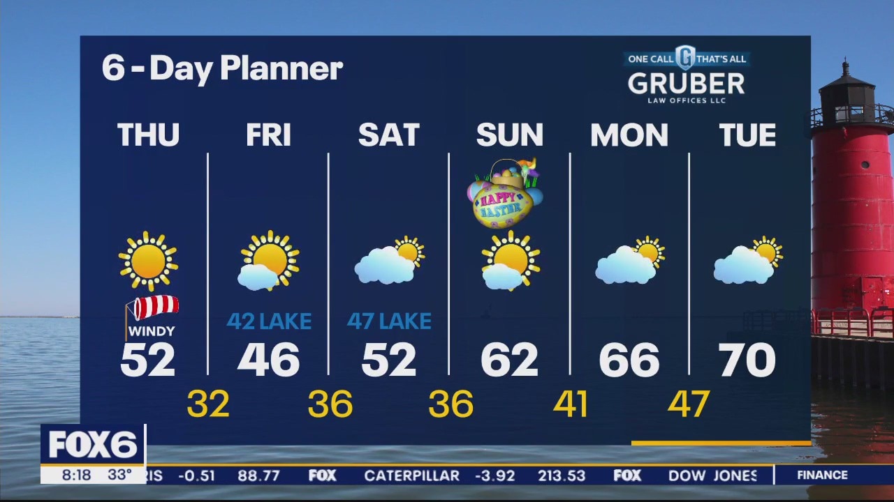
Clear skies overnight with the full moon overhead. Temperatures dropping into the upper 20s to low 30s by sunrise. Mostly sunny and windy on Thursday with highs in the upper 40s to low 50s.
Clear skies overnight with the full moon overhead. Temperatures dropping into the upper 20s to low 30s by sunrise. Mostly sunny and windy on Thursday with highs in the upper 40s to low 50s.

Weather Webcast with Tom Wachs
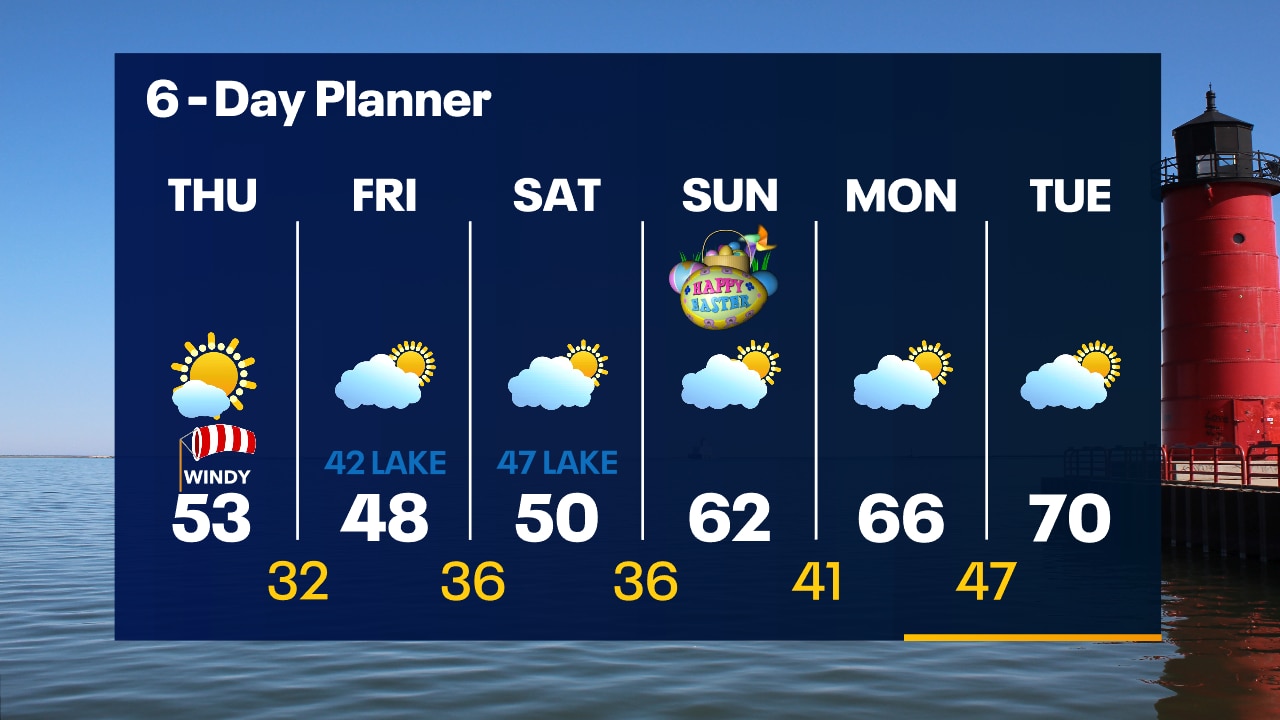
Windy with clearing skies tonight. It's going to get cold with temperatures dropping into the upper 20s to low 30s by sunrise. Mostly sunny and windy on Thursday with highs in the upper 40s to low 50s.
Windy with clearing skies tonight. It's going to get cold with temperatures dropping into the upper 20s to low 30s by sunrise. Mostly sunny and windy on Thursday with highs in the upper 40s to low 50s.
Weather Webcast with Meteorologist Eric Manges
Warm for now but much colder air rushes in tonight.
Warm for now but much colder air rushes in tonight.

Weather webcast with Lisa Mchaels
Isolated/Scattered Storms this morning. Some can be strong to severe ahead of the cold front. Cold front will pass in the early afternoon so storms will be watched closely for severe weather potential. Gradually clearing skies later this afternoon. Decreasing temperatures behind the front and windy. A long dry stretch of weather coming up. Warming back into the 60s next week.
Isolated/Scattered Storms this morning. Some can be strong to severe ahead of the cold front. Cold front will pass in the early afternoon so storms will be watched closely for severe weather potential. Gradually clearing skies later this afternoon. Decreasing temperatures behind the front and windy. A long dry stretch of weather coming up. Warming back into the 60s next week.

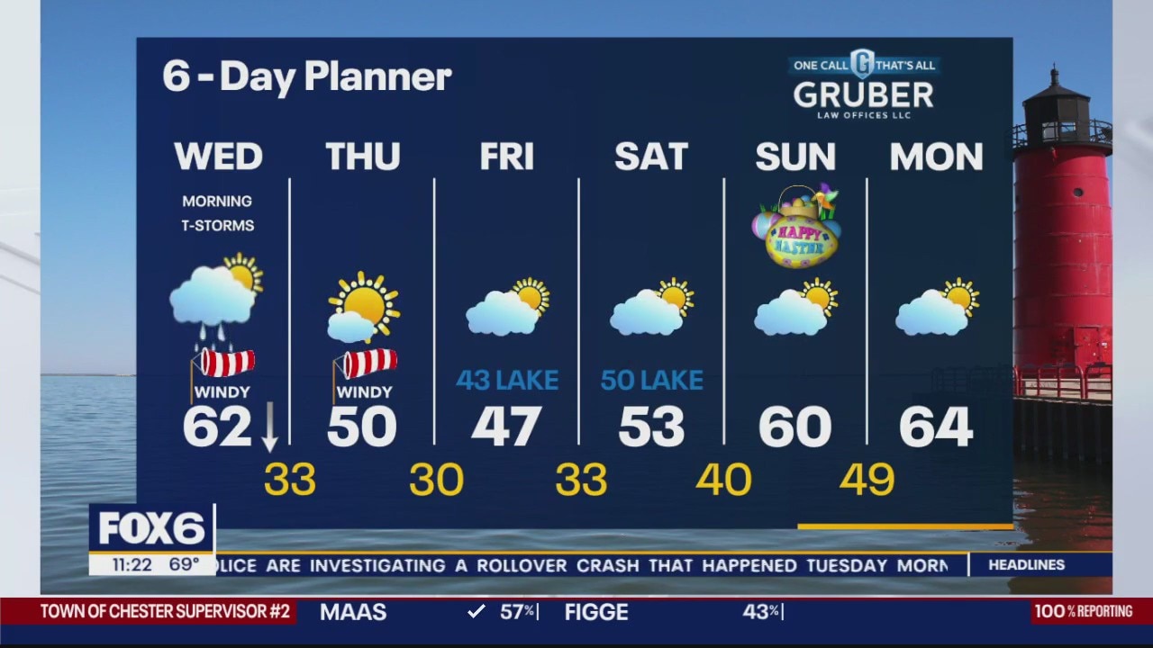
Weather Webcast with Tom Wachs
Areas of showers and t-storms overnight. Some could be strong with heavy rain. Another round of t-storms possible Wednesday morning before a cold front comes through mid-to-late morning. Morning temperatures in the 60s.
Areas of showers and t-storms overnight. Some could be strong with heavy rain. Another round of t-storms possible Wednesday morning before a cold front comes through mid-to-late morning. Morning temperatures in the 60s.

Weather Webcast with Tom Wachs
Round 2 of strong to severe t-storms likely late this evening overnight. Wind, hail and tornadoes possible. Warming into the 60s overnight. A third round of storms possible Wednesday morning.
Round 2 of strong to severe t-storms likely late this evening overnight. Wind, hail and tornadoes possible. Warming into the 60s overnight. A third round of storms possible Wednesday morning.