

Weather Webcast with Stephanie Barichello
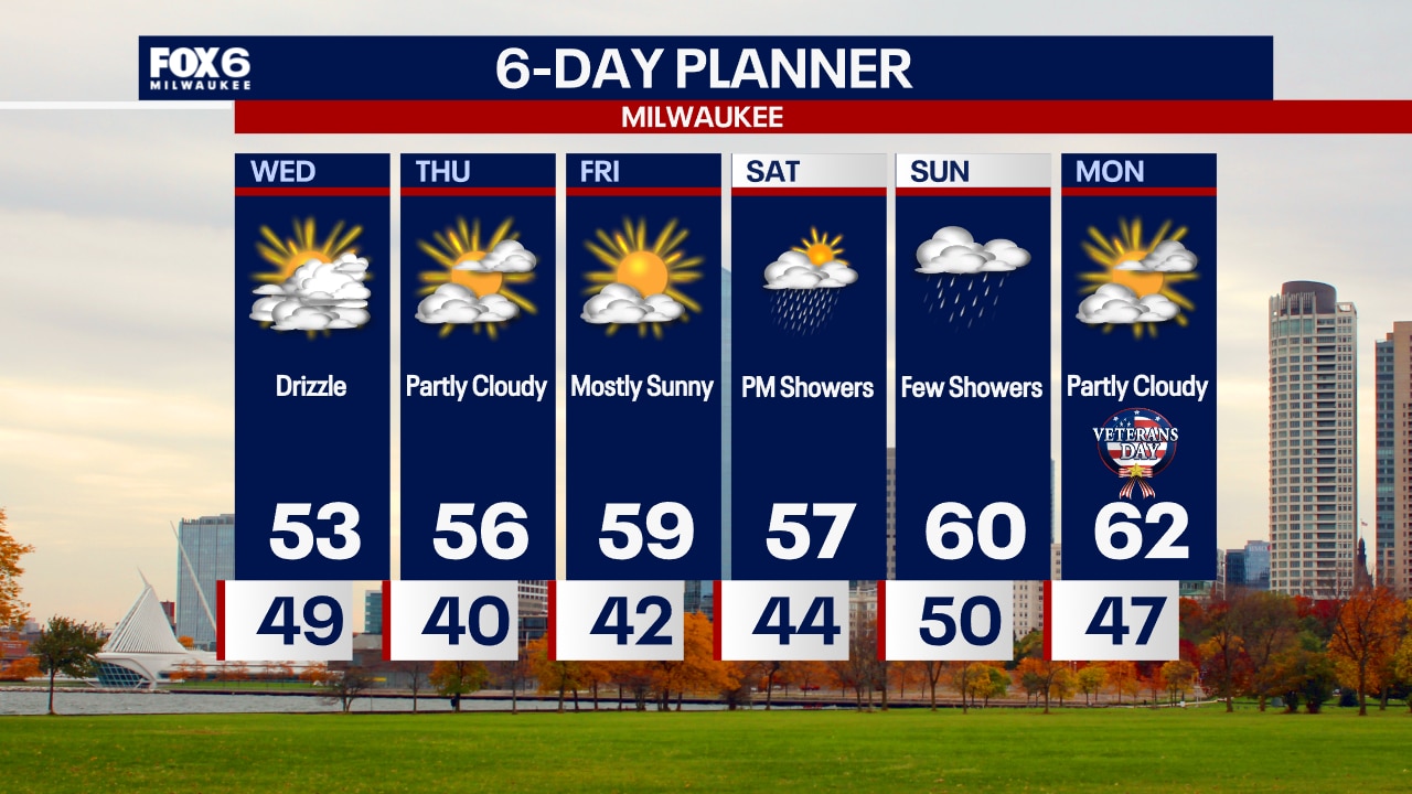
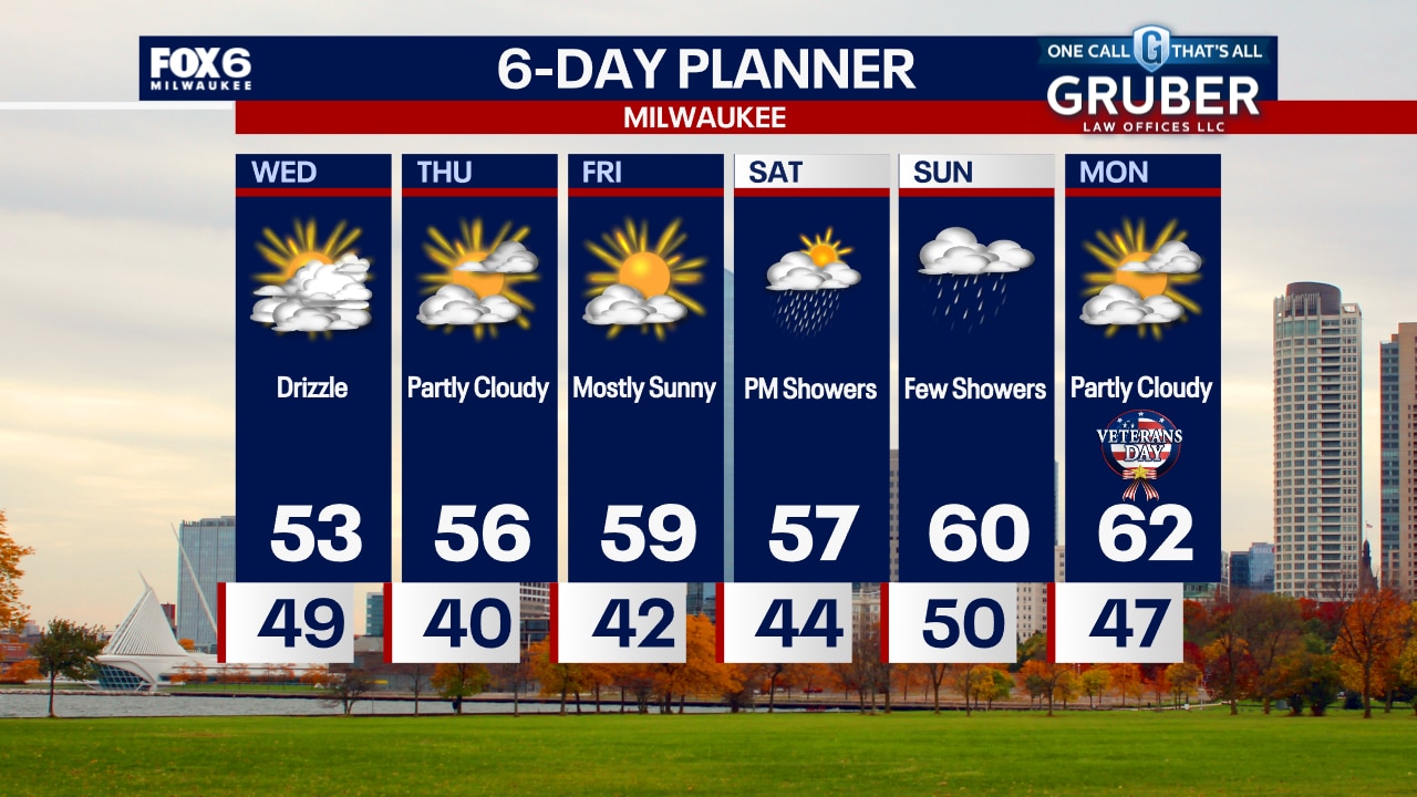
Drizzle this afternoon then clouds decrease overnight. Temperatures will reach into the low 50s today then drop into the 30s by morning. Sunny the rest of the week, then a chance for rain over the weekend.
Drizzle this afternoon then clouds decrease overnight. Temperatures will reach into the low 50s today then drop into the 30s by morning. Sunny the rest of the week, then a chance for rain over the weekend.

Weather webcast with Rob Haswell
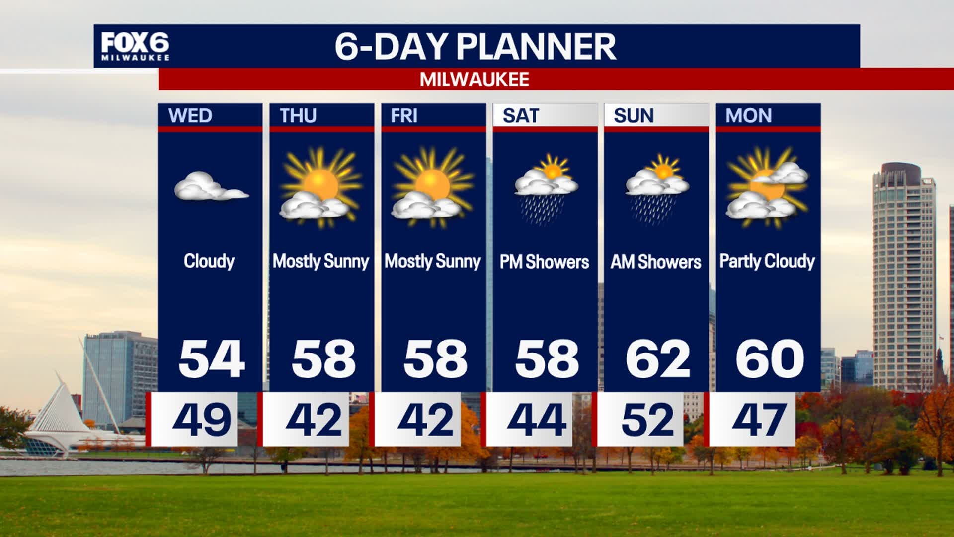
High pressure builds back into our area today with drier and cooler air. Highs will fall to the low 50s which is more typical for this time of year. We should see some partial clearing by the end of the day and clear out further overnight allowing us to cool into the upper 30s and low 40s into Thursday morning. A couple of pleasant days for Thursday and Friday with some sun and above average temperatures. Showers return for later Saturday into Sunday. We remain above the climate averages into early next week.
High pressure builds back into our area today with drier and cooler air. Highs will fall to the low 50s which is more typical for this time of year. We should see some partial clearing by the end of the day and clear out further overnight allowing us to cool into the upper 30s and low 40s into Thursday morning. A couple of pleasant days for Thursday and Friday with some sun and above average temperatures. Showers return for later Saturday into Sunday. We remain above the climate averages into early next week.
Weather Webcast with Chief Meteorologist Tom Wachs
Mostly cloudy overnight with temperatures dropping into the 40s. Mostly cloudy and much cooler on Wednesday with patchy drizzle. Highs in the low 50s.
Mostly cloudy overnight with temperatures dropping into the 40s. Mostly cloudy and much cooler on Wednesday with patchy drizzle. Highs in the low 50s.
Weather Webcast with Chief Meteorologist Tom Wachs
Rain will taper off this evening as a cold front comes through. Temperatures will drop into the 40s overnight. Mostly cloudy with patchy drizzle on Wednesday. Much cooler with highs in the low 50s.
Rain will taper off this evening as a cold front comes through. Temperatures will drop into the 40s overnight. Mostly cloudy with patchy drizzle on Wednesday. Much cooler with highs in the low 50s.

Weather Webcast with Stephanie Barichello
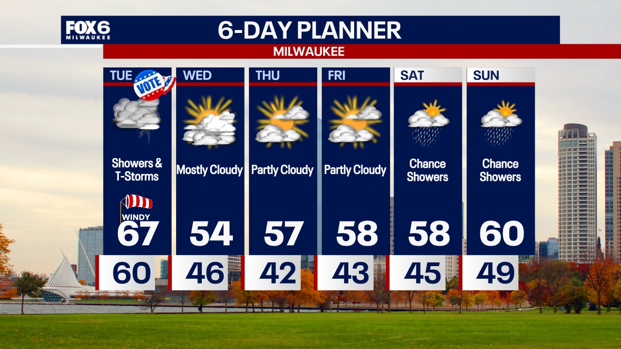
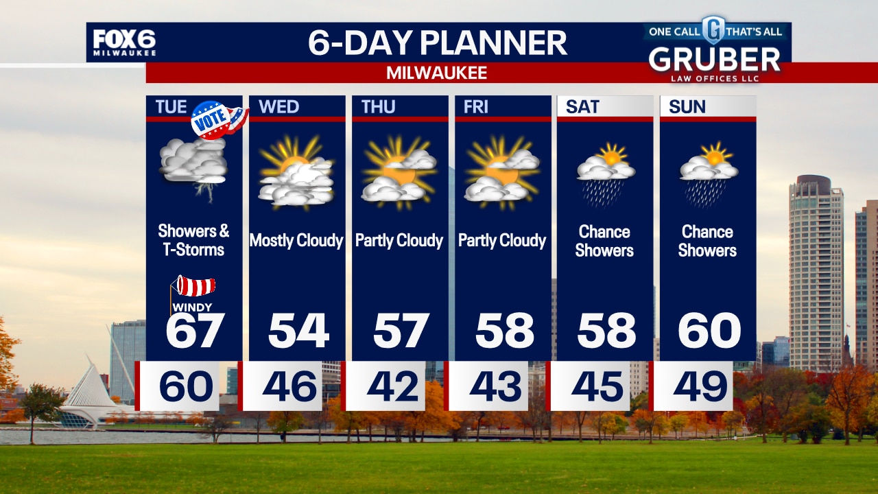
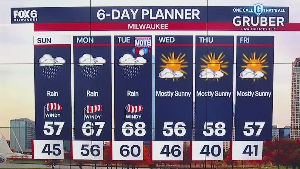
Scattered showers and thunderstorms expected through dinner time, so bring an umbrella to the polls if you'll be out. It'll also be windy and warm. Cooler Wednesday with highs in the 50s, then temperatures gradually climb to near 60 on Friday. Another round of rain showers expected this weekend.
Scattered showers and thunderstorms expected through dinner time, so bring an umbrella to the polls if you'll be out. It'll also be windy and warm. Cooler Wednesday with highs in the 50s, then temperatures gradually climb to near 60 on Friday. Another round of rain showers expected this weekend.
Weather webcast with Rob Haswell
Periods of rain today, heavy at times and a slight chance for thunderstorms as a low pressure system makes its way through our area. Very mild today with highs in the upper 60s once again. Cooler tonight with lows in the upper 30s and low 40s. A dry and more seasonal Wednesday with highs in the low 50s but we warm again late week with highs reaching near 60 by Friday. Our weekend is looking wetter and mild with highs in the upper 50s and a chance for showers through parts of both days.
Periods of rain today, heavy at times and a slight chance for thunderstorms as a low pressure system makes its way through our area. Very mild today with highs in the upper 60s once again. Cooler tonight with lows in the upper 30s and low 40s. A dry and more seasonal Wednesday with highs in the low 50s but we warm again late week with highs reaching near 60 by Friday. Our weekend is looking wetter and mild with highs in the upper 50s and a chance for showers through parts of both days.
Weather Webcast with Tom Wachs
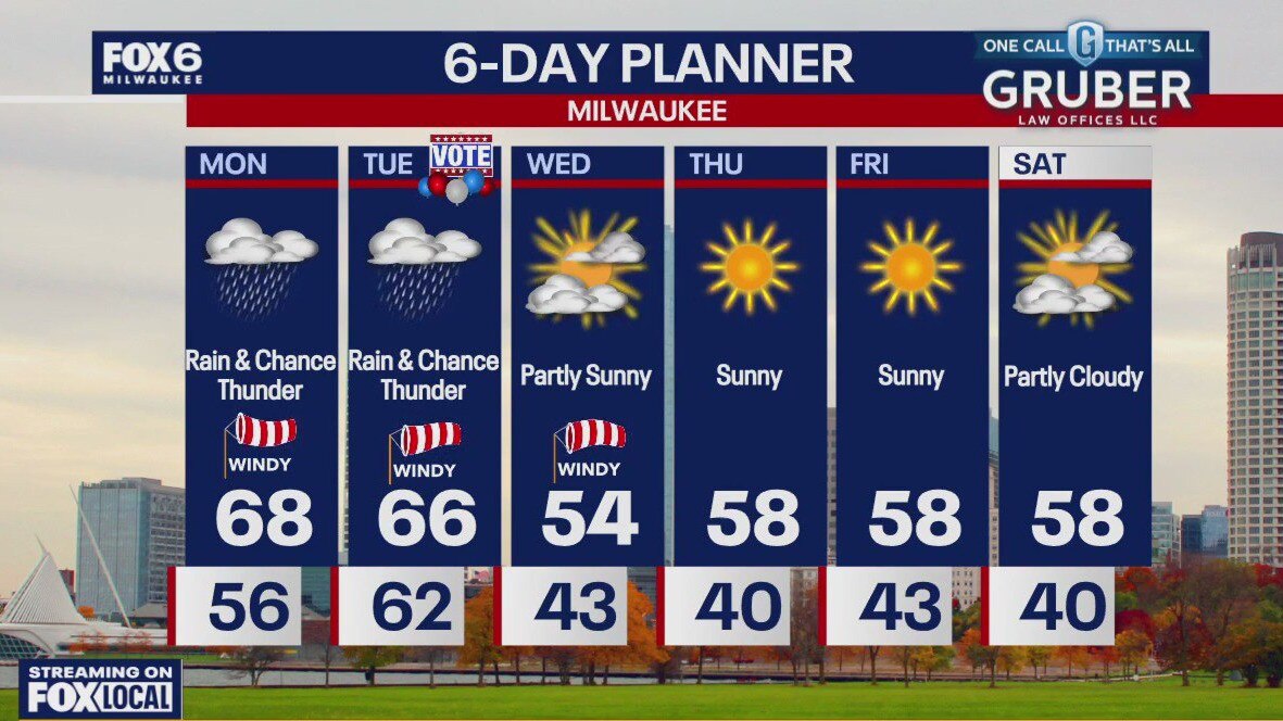
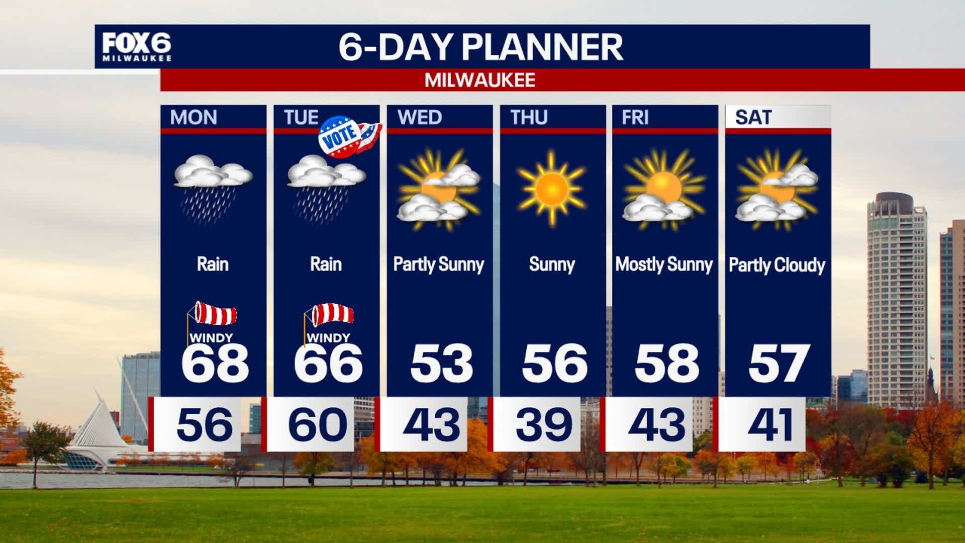
Rain and a few rumbles really picking up overnight with temperatures in the 60s. Rainy on Election Day with a few embedded t-storms. Highs in the 60s with a strong southerly wind.
Rain and a few rumbles really picking up overnight with temperatures in the 60s. Rainy on Election Day with a few embedded t-storms. Highs in the 60s with a strong southerly wind.
Weather Webcast with Tom Wachs
Scattered showers this evening will transition to heavy rain after 11pm. Rain and a few storms overnight. Rain and a few storms continue on Election Day with a windy high in the mid-60s.
Scattered showers this evening will transition to heavy rain after 11pm. Rain and a few storms overnight. Rain and a few storms continue on Election Day with a windy high in the mid-60s.

Weather Webcast with Stephanie Barichello
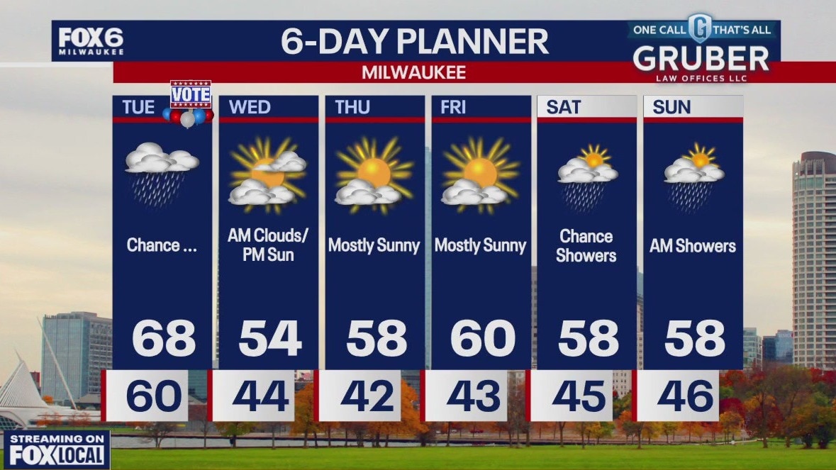
More rain is on the way tonight, potentially heavy in some far southeastern counties. Showers become scattered Tuesday morning, then a few thunderstorms will be possible in the afternoon. Strong, gusty wind will also be possible. Staying mild and muggy with temperatures in the upper 60s. Back to 50s and sunshine the rest of the week.
More rain is on the way tonight, potentially heavy in some far southeastern counties. Showers become scattered Tuesday morning, then a few thunderstorms will be possible in the afternoon. Strong, gusty wind will also be possible. Staying mild and muggy with temperatures in the upper 60s. Back to 50s and sunshine the rest of the week.
Weather webcast with Rob Haswell
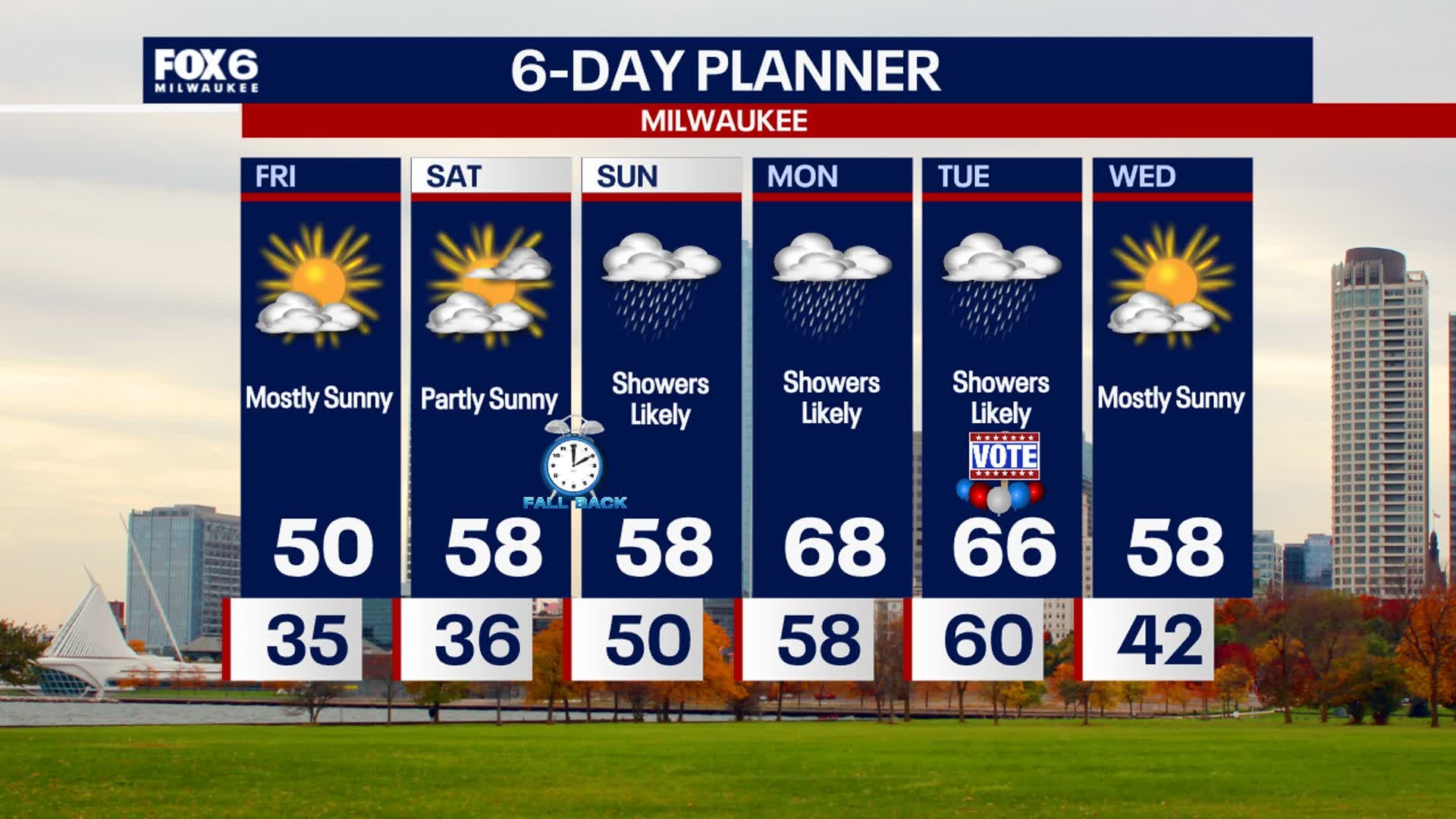
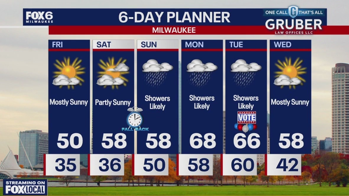
A warm front has pushed north of us this morning and will keep us seasonally mild with highs in the upper 60s. The low moving our way also brings rain, possibly heavier at times and a risk for thunderstorms today and tomorrow. We remain mild through Tuesday but temperatures return to near seasonal values Wednesday. We should dry up for a few days after tomorrow.
A warm front has pushed north of us this morning and will keep us seasonally mild with highs in the upper 60s. The low moving our way also brings rain, possibly heavier at times and a risk for thunderstorms today and tomorrow. We remain mild through Tuesday but temperatures return to near seasonal values Wednesday. We should dry up for a few days after tomorrow.
Weather Webcast with Holly Baker
The rain and windy conditions continue through election day.
The rain and windy conditions continue through election day.
Weather webcast with Lisa Michaels
Cloudy with an isolated shower in the morning. Rain chances increase during the afternoon and evening. More rain is on the way for Monday and Tuesday.
Cloudy with an isolated shower in the morning. Rain chances increase during the afternoon and evening. More rain is on the way for Monday and Tuesday.

Weather Webcast with Holly Baker.
More rain is on the way.
More rain is on the way.

Weather Webcast with Holly Baker
Cooler temperatures and dry conditions start the weekend.
Cooler temperatures and dry conditions start the weekend.
Weather Webcast with Stephanie Barichello
Sunny and cool today, then nearing 60 on Saturday. A soaking rain returns Sunday, and will continue at times into Monday and Tuesday.
Sunny and cool today, then nearing 60 on Saturday. A soaking rain returns Sunday, and will continue at times into Monday and Tuesday.
Weather webcast with Rob Haswell
Much colder today behind yesterday's passing cold front. High pressure builds back into the area to calm the wind and clear the sky. Sunny but chilly highs today near 50 and falling into the 30s overnight. We warm up a bit on Saturday with upper 50s likely and then warm well into the 60s early next week. Rain returns to the area Saturday night and we expect several rounds of showers and possible thunderstorms through later Tuesday.
Much colder today behind yesterday's passing cold front. High pressure builds back into the area to calm the wind and clear the sky. Sunny but chilly highs today near 50 and falling into the 30s overnight. We warm up a bit on Saturday with upper 50s likely and then warm well into the 60s early next week. Rain returns to the area Saturday night and we expect several rounds of showers and possible thunderstorms through later Tuesday.

Weather Webcast with Holly Baker
Windy conditions sweep through SE WI.
Windy conditions sweep through SE WI.
Weather Webcast with Stephanie Barichello
Very windy this afternoon with dropping temperatures, eventually into the 40s after sunset. Wind gusts could be up to 50mph at times. Sunny but cool Friday with highs in the low 50s, then around 60 on Saturday. Rainy conditions return Sunday and continue into early next week.
Very windy this afternoon with dropping temperatures, eventually into the 40s after sunset. Wind gusts could be up to 50mph at times. Sunny but cool Friday with highs in the low 50s, then around 60 on Saturday. Rainy conditions return Sunday and continue into early next week.
Weather webcast with Rob Haswell
A few showers this morning then drying up and getting very windy. A Wind Advisory is in place for our viewing area through 10pm with wind gusts near 50mph at times. With the passing cold front, temperatures will be mild early then fall rapidly into the low 50s by late afternoon and into the 30s overnight. Wind speeds will calm by Friday but much cooler air takes over with highs in the low 50s. A seasonally mild weekend on tap with highs in the upper 50s to near 60. A more active patter develops early next week with a few chances for showers.
A few showers this morning then drying up and getting very windy. A Wind Advisory is in place for our viewing area through 10pm with wind gusts near 50mph at times. With the passing cold front, temperatures will be mild early then fall rapidly into the low 50s by late afternoon and into the 30s overnight. Wind speeds will calm by Friday but much cooler air takes over with highs in the low 50s. A seasonally mild weekend on tap with highs in the upper 50s to near 60. A more active patter develops early next week with a few chances for showers.
Weather webcast with Lisa Michaels
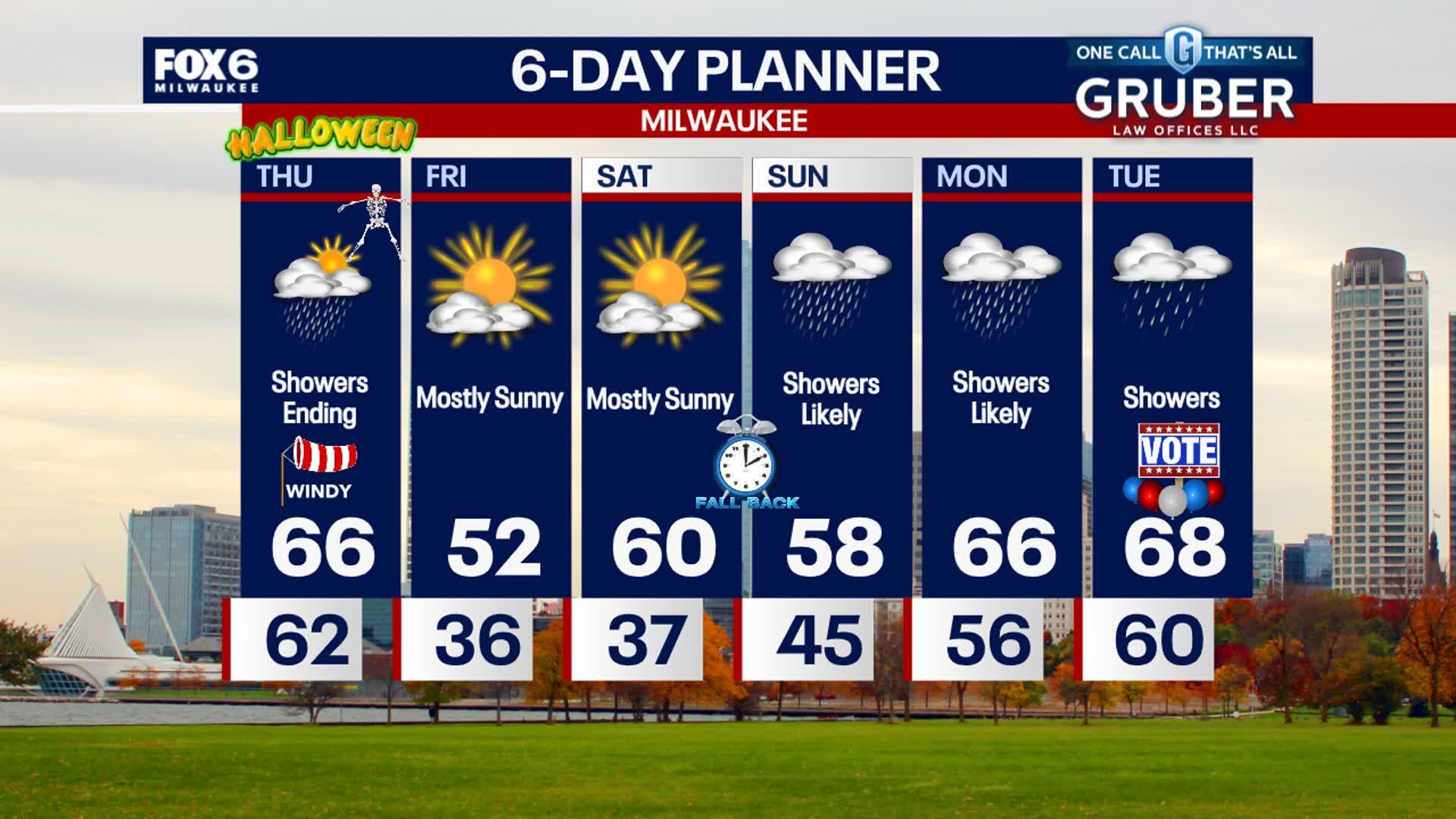
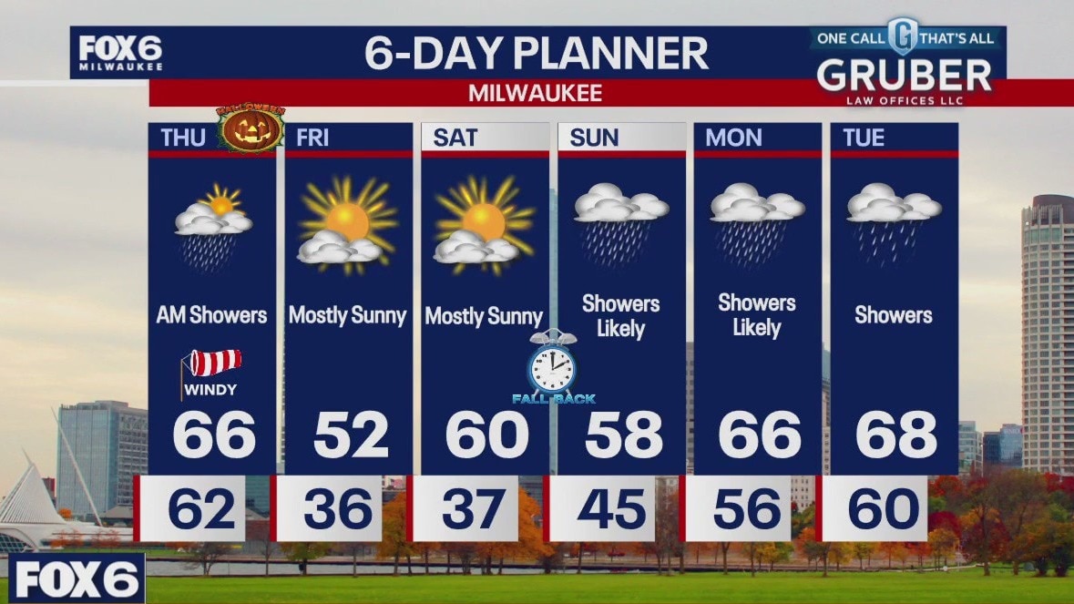
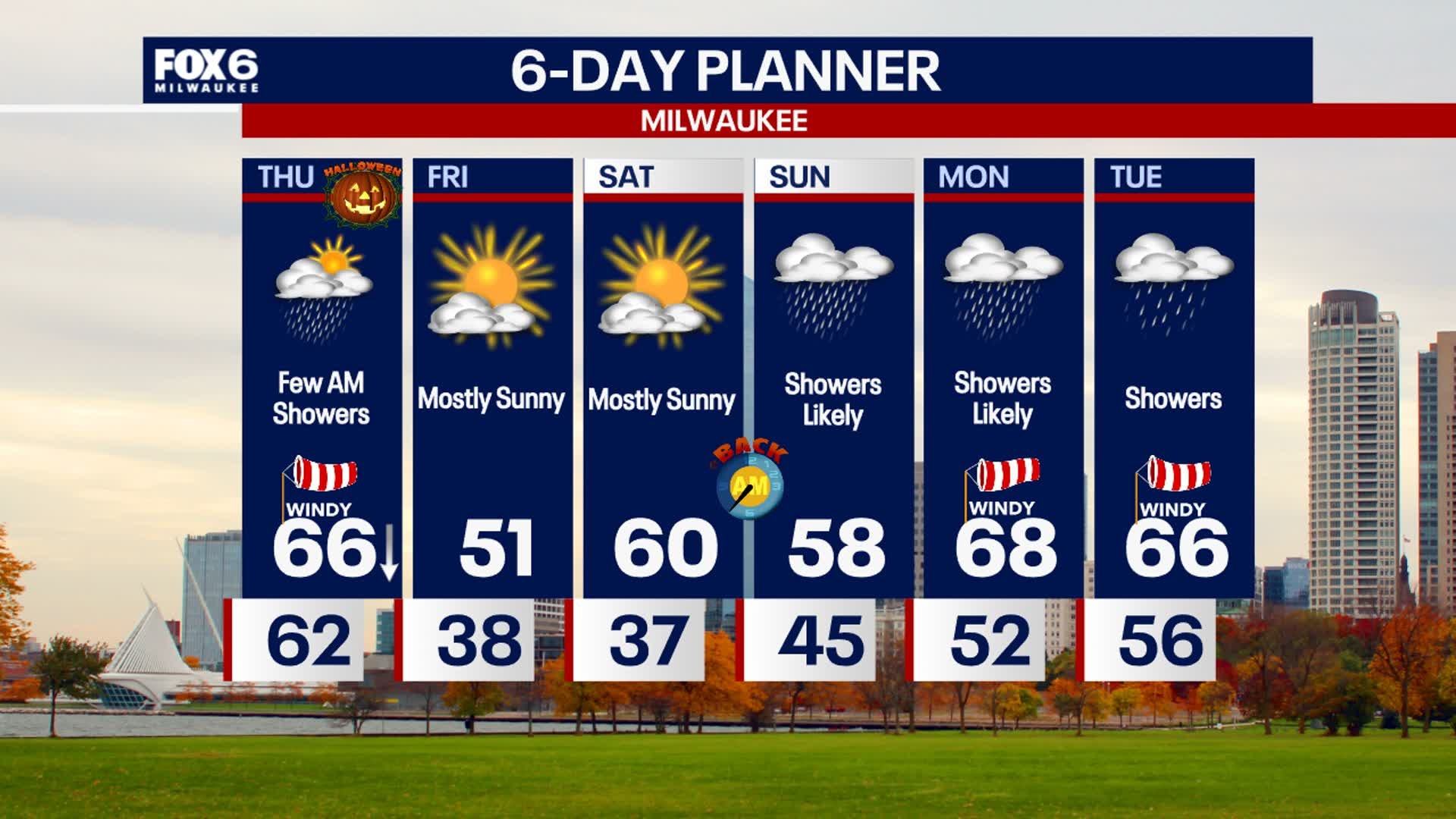
Strong winds continue tonight through Thursday. A wind advisory has been issued from 10AM to 10PM on Thursday for gusts up to 45mph. Rain and storms move into southeast Wisconsin late Wednesday night. Isolated strong to severe storms could bring damaging winds. Storms will weaken as it moves east towards the lake by Thursday morning. Early showers on Thursday are likely and clearing by the afternoon. Temperatures begin to drop on Halloween, Thursday, causing for a cool and windy trick-or-treat forecast.
Strong winds continue tonight through Thursday. A wind advisory has been issued from 10AM to 10PM on Thursday for gusts up to 45mph. Rain and storms move into southeast Wisconsin late Wednesday night. Isolated strong to severe storms could bring damaging winds. Storms will weaken as it moves east towards the lake by Thursday morning. Early showers on Thursday are likely and clearing by the afternoon. Temperatures begin to drop on Halloween, Thursday, causing for a cool and windy trick-or-treat forecast.