

Weather webcast with Rob Haswell
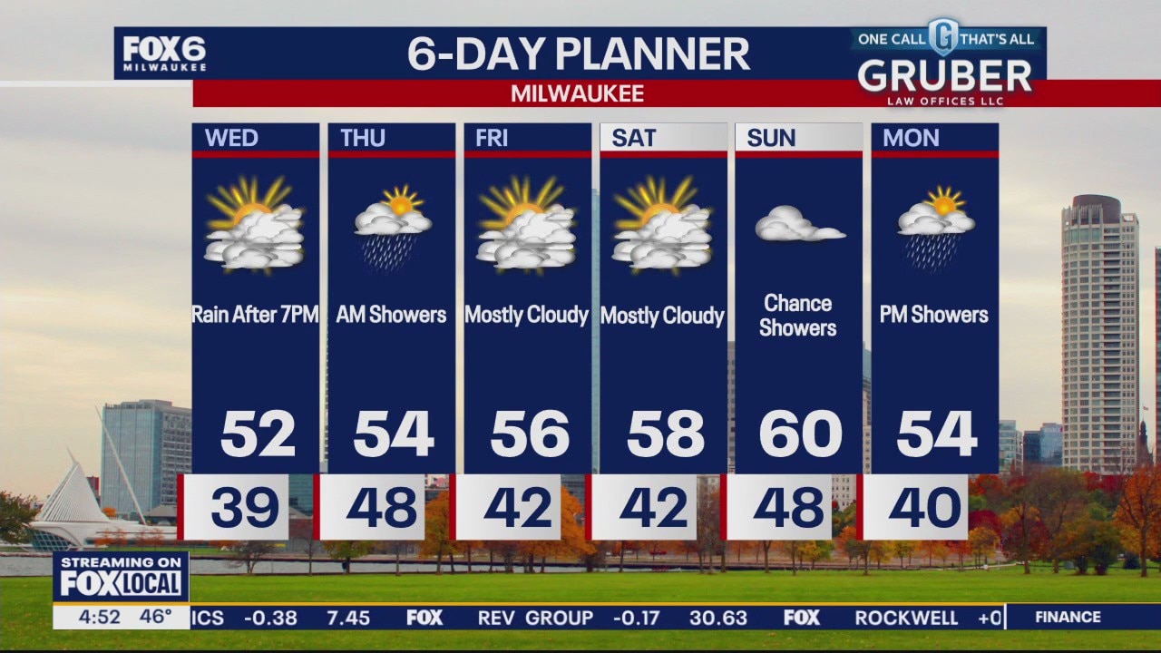
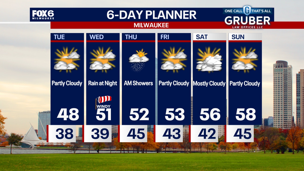
Cloudy for our Wednesday with rain arriving after 7pm. Highs will be in the low 50s today and we stay well into the 40s overnight. Rain persists overnight into the first half of the day Thursday before drying up. With a few hours of steady light to moderate rain, we could see up to 1 inch in some areas. Dry and seasonally mild for Friday and Saturday with highs reaching the upper 50s both days. Rain returns for Sunday and into Monday.
Cloudy for our Wednesday with rain arriving after 7pm. Highs will be in the low 50s today and we stay well into the 40s overnight. Rain persists overnight into the first half of the day Thursday before drying up. With a few hours of steady light to moderate rain, we could see up to 1 inch in some areas. Dry and seasonally mild for Friday and Saturday with highs reaching the upper 50s both days. Rain returns for Sunday and into Monday.
Weather Webcast with Chief Meteorologist Tom Wachs
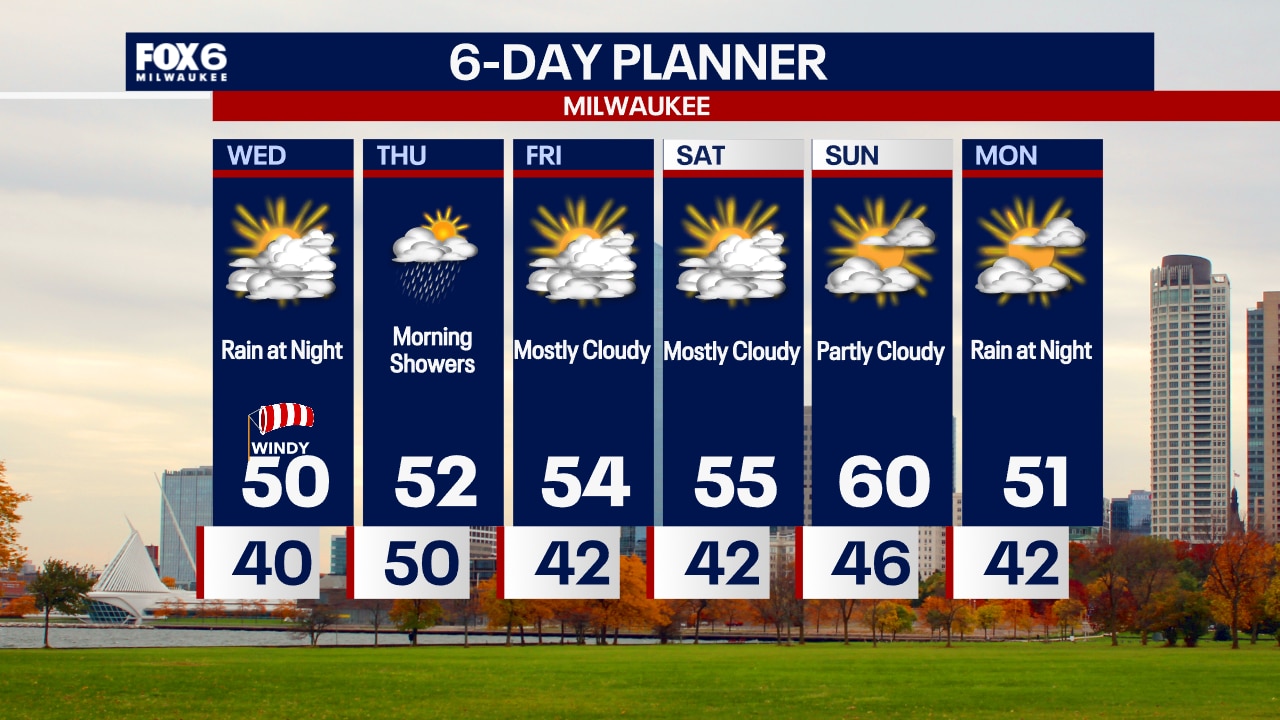
Quiet overnight with temperatures in the 30s to around 40 by sunrise. Increasing clouds and windy on Wednesday with a high around 50. Rain moves in from the south after 7pm Wednesday.
Quiet overnight with temperatures in the 30s to around 40 by sunrise. Increasing clouds and windy on Wednesday with a high around 50. Rain moves in from the south after 7pm Wednesday.

Weather Webcast with Chief Meteorologist Tom Wachs
Mostly clear to partly cloudy tonight with temperatures in the 30s to around 40. Increasing clouds on Wednesday with a windy high around 50. Rain moves in Wednesday night.
Mostly clear to partly cloudy tonight with temperatures in the 30s to around 40. Increasing clouds on Wednesday with a windy high around 50. Rain moves in Wednesday night.
Weather webcast with Rob Haswell
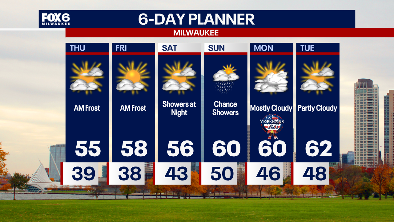
A cloudy start but we should see sunny breaks by the afternoon and seasonal highs in the upper 40s to near 50 degrees. We should be dry overnight and into early Wednesday but rain returns by Wednesday evening. Wednesday's highs will reach the low 50s. We dry up again Thursday afternoon through most of the weekend with the next chance of precipitation being later Sunday. A warm up starts Thursday and by the weekend we are in the upper 50s in most areas which is 8 to 10 degrees above the climate norms for the period.
A cloudy start but we should see sunny breaks by the afternoon and seasonal highs in the upper 40s to near 50 degrees. We should be dry overnight and into early Wednesday but rain returns by Wednesday evening. Wednesday's highs will reach the low 50s. We dry up again Thursday afternoon through most of the weekend with the next chance of precipitation being later Sunday. A warm up starts Thursday and by the weekend we are in the upper 50s in most areas which is 8 to 10 degrees above the climate norms for the period.
Weather Webcast with Chief Meteorologist Tom Wachs
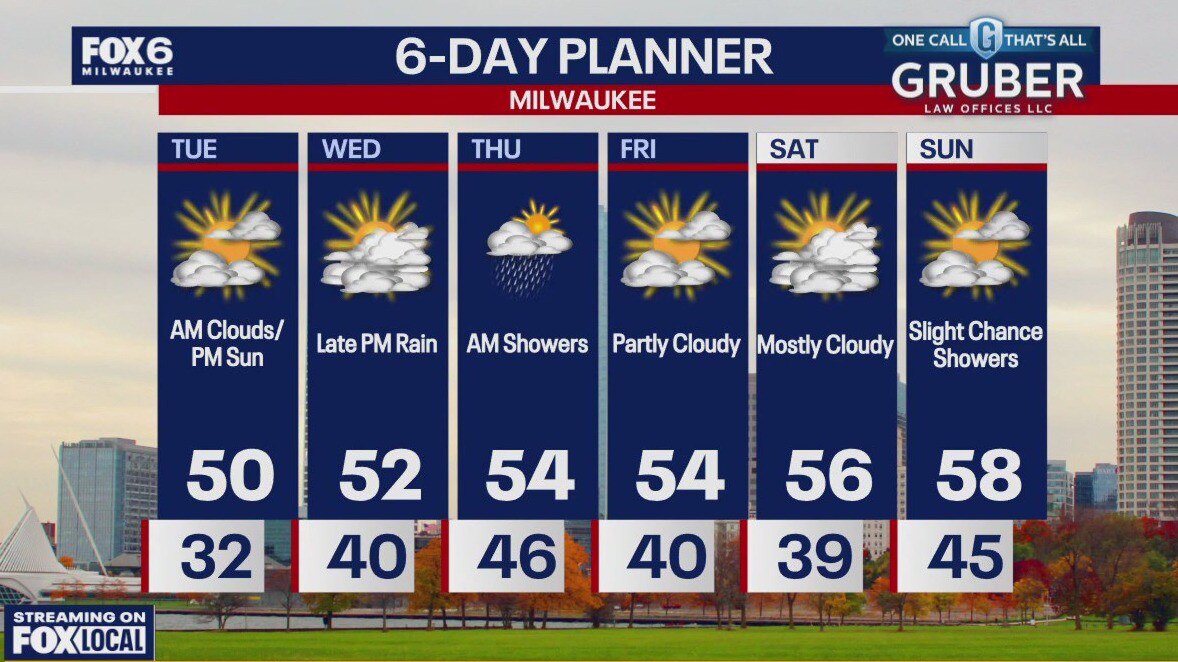
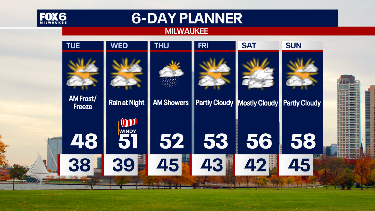
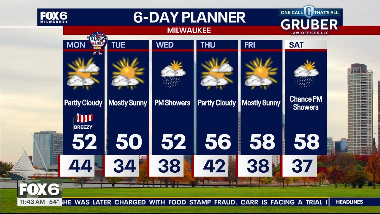
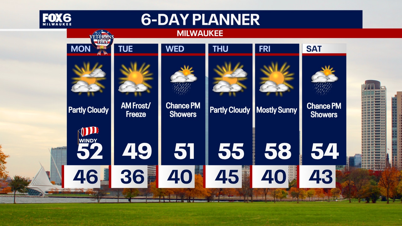
Frost is possible near the lake overnight with a freeze inland. Partly sunny, blustery and cool on Tuesday with highs in the 40s. Rain chances hold off until Wednesday night.
Frost is possible near the lake overnight with a freeze inland. Partly sunny, blustery and cool on Tuesday with highs in the 40s. Rain chances hold off until Wednesday night.
Weather Webcast with Chief Meteorologist Tom Wachs
A frost near the lake and a freeze inland is possible overnight as temperatures dip into the 30s. Partly sunny, blustery and cool again on Tuesday with highs in the 40s.
A frost near the lake and a freeze inland is possible overnight as temperatures dip into the 30s. Partly sunny, blustery and cool again on Tuesday with highs in the 40s.
Weather webcast with Lisa Michaels
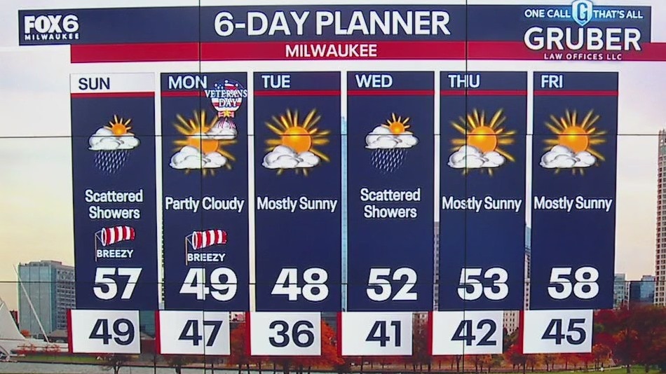
A cold front passes through our area today dropping temperatures from the low 50s early to the low 40s by late afternoon and into the low 30s overnight! The front will pass without any precipitation but will generate strong NW wind gusts in excess of 30mph at times. We will be near 50 on Tuesday with some sun but then warm a bit later this week, climbing to the upper 50s by Friday and into the weekend.
A cold front passes through our area today dropping temperatures from the low 50s early to the low 40s by late afternoon and into the low 30s overnight! The front will pass without any precipitation but will generate strong NW wind gusts in excess of 30mph at times. We will be near 50 on Tuesday with some sun but then warm a bit later this week, climbing to the upper 50s by Friday and into the weekend.

Weather webcast with Rob Haswell
A cold front passes through our area today dropping temperatures from the low 50s early to the low 40s by late afternoon and into the low 30s overnight! The front will pass without any precipitation but will generate strong NW wind gusts in excess of 30mph at times. We will be near 50 on Tuesday with some sun but then warm a bit later this week, climbing to the upper 50s by Friday and into the weekend. We can expect more rain by Wednesday afternoon and again by Sunday.
A cold front passes through our area today dropping temperatures from the low 50s early to the low 40s by late afternoon and into the low 30s overnight! The front will pass without any precipitation but will generate strong NW wind gusts in excess of 30mph at times. We will be near 50 on Tuesday with some sun but then warm a bit later this week, climbing to the upper 50s by Friday and into the weekend. We can expect more rain by Wednesday afternoon and again by Sunday.

Weather Webcast with Chief Meteorologist Tom Wachs
Partly sunny and windy on Monday with temperatures in the 40s to low 50s. Cool again on Tuesday before rain chances return on Wednesday afternoon.
Partly sunny and windy on Monday with temperatures in the 40s to low 50s. Cool again on Tuesday before rain chances return on Wednesday afternoon.
Weather Webcast with Chief Meteorologist Tom Wachs
Rain will taper off this evening with temperatures dropping into the 40s. Partly sunny & windy on Monday with highs in the low 50s.
Rain will taper off this evening with temperatures dropping into the 40s. Partly sunny & windy on Monday with highs in the low 50s.
Weather webcast with Lisa Michaels
Drizzle and fog will be the primary impacts Sunday morning. Rain and a few rumbles of thunder return by this late morning/afternoon. Activity will move out tonight.
Drizzle and fog will be the primary impacts Sunday morning. Rain and a few rumbles of thunder return by this late morning/afternoon. Activity will move out tonight.

Weather Webcast with Holly Baker
Rain pushes through SE WI tonight into Sunday.
Rain pushes through SE WI tonight into Sunday.

Weather webcast with Stephanie Barichello
Increasing clouds today with temperatures in the middle 50s. Rain showers move in this evening and last into early Sunday. Drizzle will continue at times Sunday, then a few more rain showers midday. It'll also be a windy day.
Increasing clouds today with temperatures in the middle 50s. Rain showers move in this evening and last into early Sunday. Drizzle will continue at times Sunday, then a few more rain showers midday. It'll also be a windy day.

Weather Webcast with Holly Baker
More rain returns late Saturday.
More rain returns late Saturday.
Weather webcast with Rob Haswell
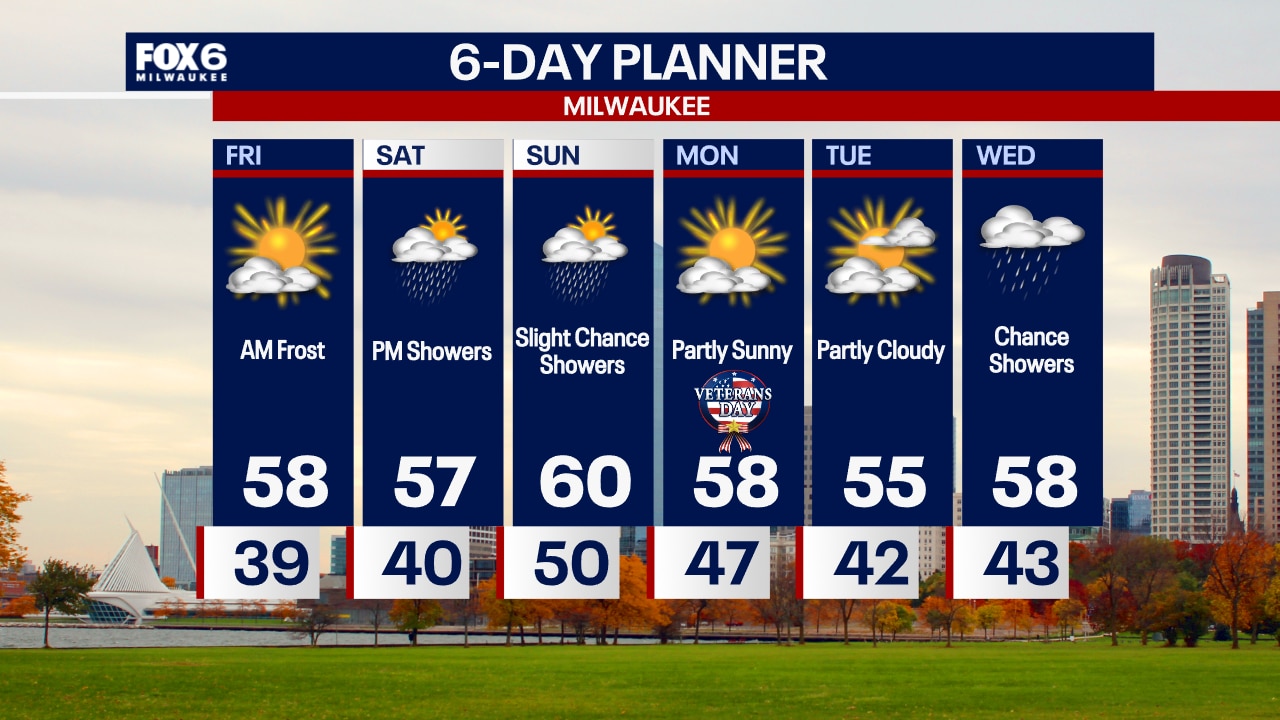
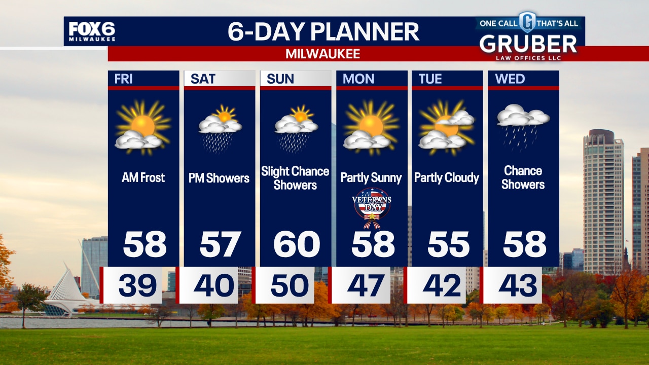
High pressure again dominates our forecast with clear conditions and seasonally mild temperatures. An approaching low brings more clouds overnight and through the day on Saturday with rain showers likely by early evening. Rain chances continue into Sunday but dry up by late in the day. We remain above average for temperatures over the weekend. A dry and mild start to next week with rain returning by Wednesday.
High pressure again dominates our forecast with clear conditions and seasonally mild temperatures. An approaching low brings more clouds overnight and through the day on Saturday with rain showers likely by early evening. Rain chances continue into Sunday but dry up by late in the day. We remain above average for temperatures over the weekend. A dry and mild start to next week with rain returning by Wednesday.
Weather Webcast with Chief Meteorologist Tom Wachs
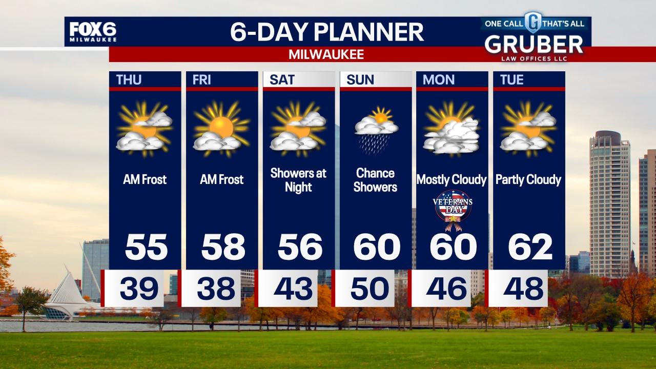
Clear skies with patchy frost overnight as temperatures drop into the 30s. Mostly sunny on Friday with highs in the upper 50s. Rain chances return Saturday afternoon/evening.
Clear skies with patchy frost overnight as temperatures drop into the 30s. Mostly sunny on Friday with highs in the upper 50s. Rain chances return Saturday afternoon/evening.
Weather Webcast with Chief Meteorologist Tom Wachs
Clear skies tonight with temperatures dropping into the 40s. Another day of sun on Friday with highs in the 50s.
Clear skies tonight with temperatures dropping into the 40s. Another day of sun on Friday with highs in the 50s.

Weather webcast with Rob Haswell
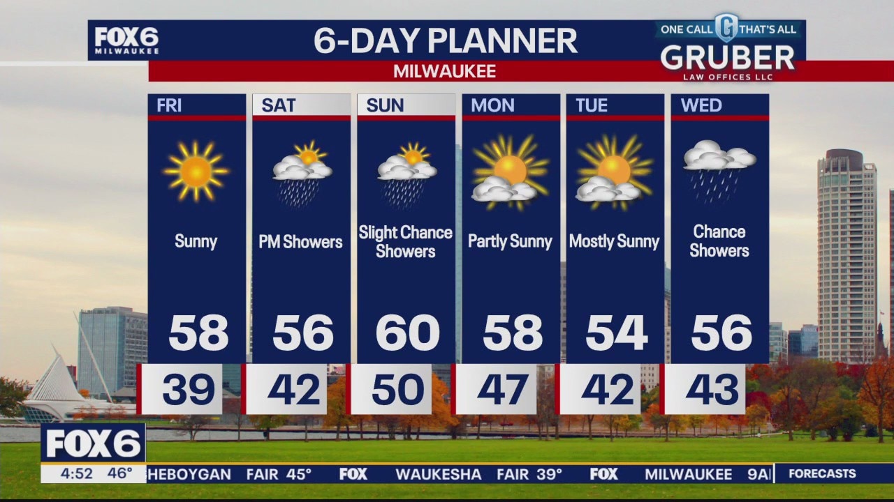
High pressure dominates our forecast for the next few days with ample sun and clear skies overnight. Highs will be a few degrees above seasonal averages hitting the mid to upper 50s today and tomorrow. Lows will be in the upper 30s. A stronger low arrives later Saturday with rain by Saturday evening lasting through Sunday afternoon. The weekend will be seasonally mild. We begin next week on a mild note.
High pressure dominates our forecast for the next few days with ample sun and clear skies overnight. Highs will be a few degrees above seasonal averages hitting the mid to upper 50s today and tomorrow. Lows will be in the upper 30s. A stronger low arrives later Saturday with rain by Saturday evening lasting through Sunday afternoon. The weekend will be seasonally mild. We begin next week on a mild note.
Weather Webcast with Chief Meteorologist Tom Wachs
Gradual clearing overnight with patchy frost and temperatures dropping into the 30s. Partly sunny on Thursday with highs in the mid-50s.
Gradual clearing overnight with patchy frost and temperatures dropping into the 30s. Partly sunny on Thursday with highs in the mid-50s.
Weather Webcast with Chief Meteorologist Tom Wachs
Gradual clearing tonight with patchy frost overnight. Temperatures dropping into the 30s overnight. Some sun returns on Thursday with highs in the mid-50s.
Gradual clearing tonight with patchy frost overnight. Temperatures dropping into the 30s overnight. Some sun returns on Thursday with highs in the mid-50s.