


Weather webcast with Lisa Michaels
Partly sunny skies on Sunday with high temps in the low 20s. Wind chills in the single digits to low teens. Clouds increase late Sunday afternoon.
Partly sunny skies on Sunday with high temps in the low 20s. Wind chills in the single digits to low teens. Clouds increase late Sunday afternoon.

Weather Webcast with Holly Baker
Cold temperatures continue with lake effect snow not too far away!
Cold temperatures continue with lake effect snow not too far away!

Weather webcast with Lisa Michaels
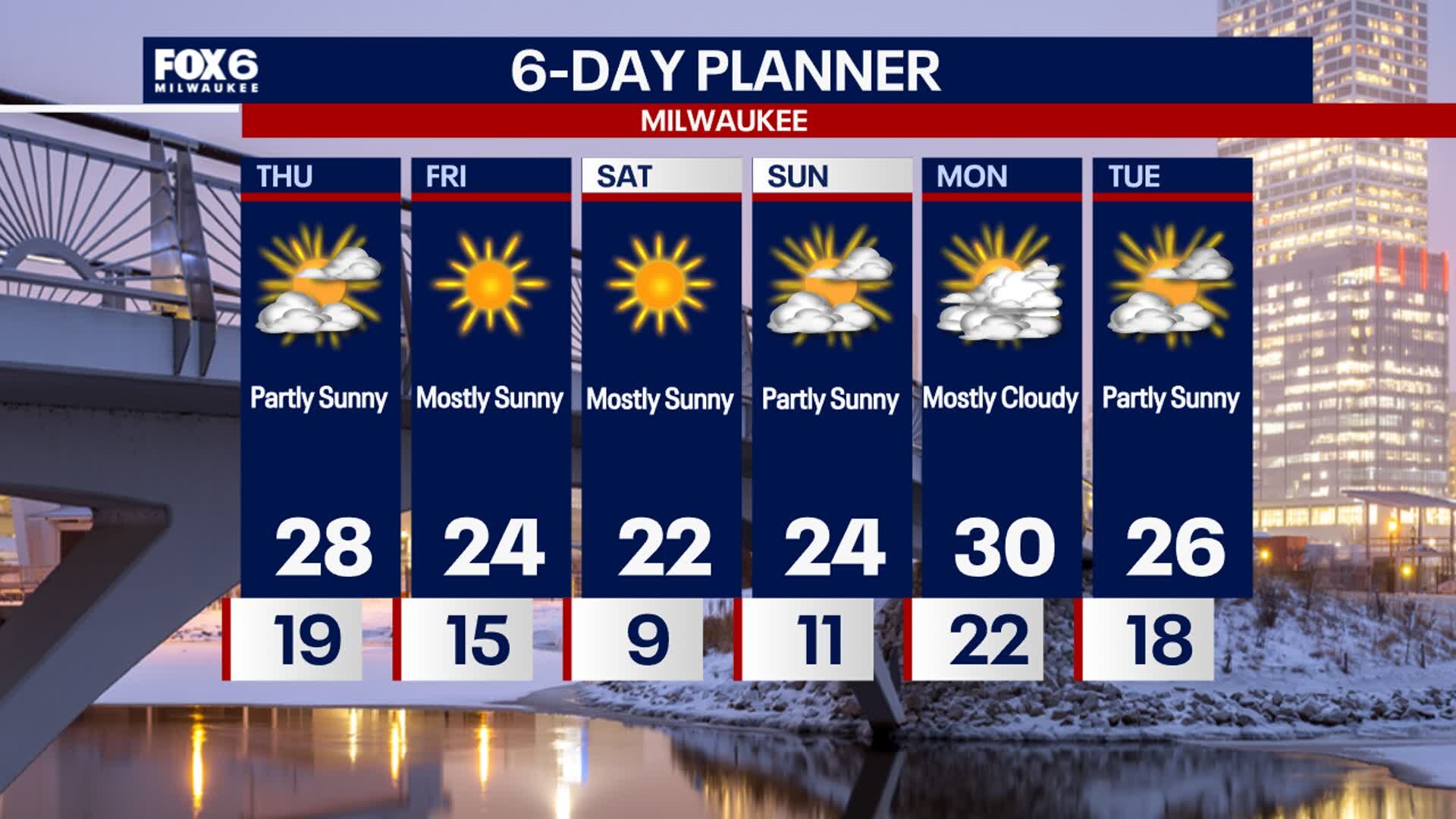
A very cold start to Saturday morning with wind chills ranging from -5? to -15? below zero. Mostly sunny during the day with highs temps in the upper teens but wind chills -5? to 5?. Partly sunny and still cold on Sunday with highs in the low 20s. A big low pressure system will stay south of Wisconsin Sunday, but as it moves east, winds will transition off of the lake and could bring lake effect snow late Sunday night into early Monday morning. Accumulating snowfall is possible. Sub-freezing high temperatures remain in the forecast for the rest of the week which is 5 to 10 degrees below average for this time of year.
A very cold start to Saturday morning with wind chills ranging from -5? to -15? below zero. Mostly sunny during the day with highs temps in the upper teens but wind chills -5? to 5?. Partly sunny and still cold on Sunday with highs in the low 20s. A big low pressure system will stay south of Wisconsin Sunday, but as it moves east, winds will transition off of the lake and could bring lake effect snow late Sunday night into early Monday morning. Accumulating snowfall is possible. Sub-freezing high temperatures remain in the forecast for the rest of the week which is 5 to 10 degrees below average for this time of year.

Webcast Weather with Holly Baker
Polar air sticks around for a few days.
Polar air sticks around for a few days.
Weather Webcast with Stephanie Barichello
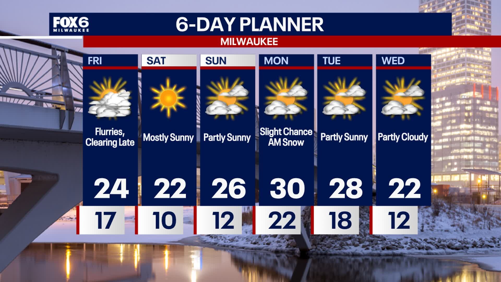
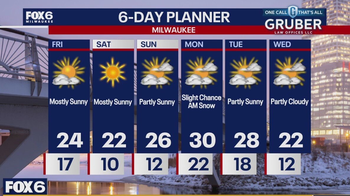
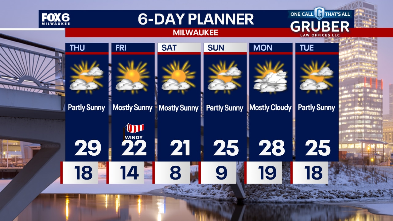
Flurries linger through mid-afternoon then decreasing clouds. It'll be windy and colder with temperatures in the 20s and wind chills in the single digits. Similar conditions on Saturday but more sunshine. A storm system with snow and ice stays south, keeping SE WI dry through next week. There is only a slight chance for lake-effect snow on Monday.
Flurries linger through mid-afternoon then decreasing clouds. It'll be windy and colder with temperatures in the 20s and wind chills in the single digits. Similar conditions on Saturday but more sunshine. A storm system with snow and ice stays south, keeping SE WI dry through next week. There is only a slight chance for lake-effect snow on Monday.
Weather webcast with Rob Haswell
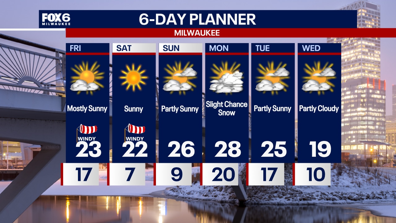
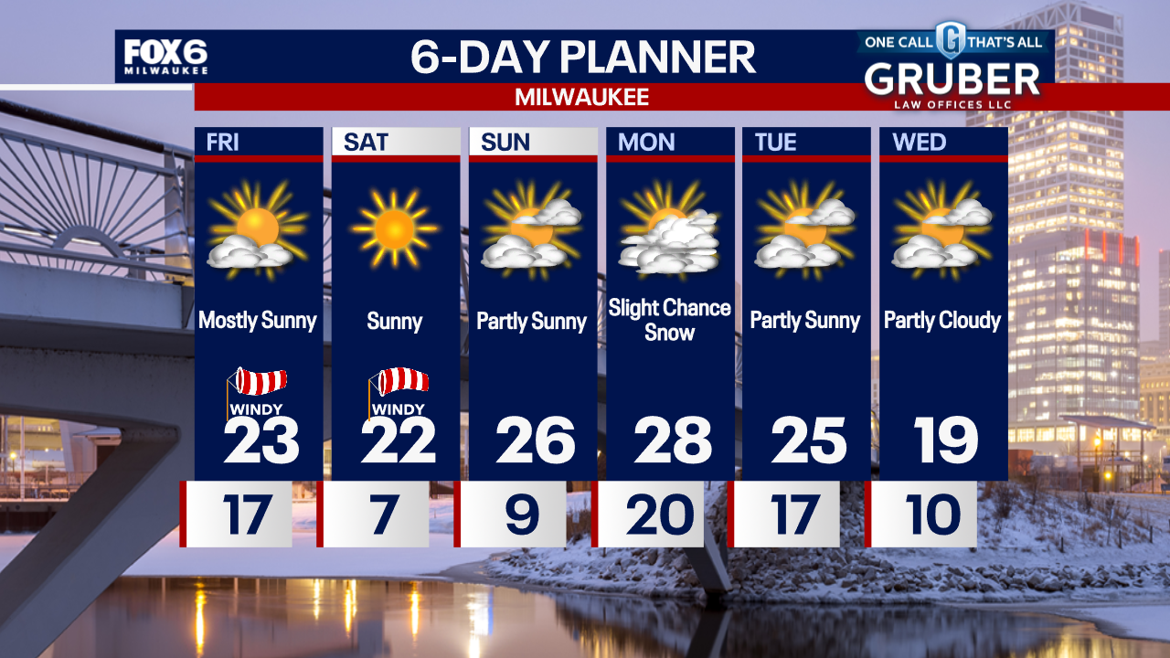
High pressure ushers in a chilly air mass today with highs in the low to mid 20s and feeling colder with a breezy NW wind. Clear conditions overnight will allow for significant cooling. Lows will dip into the single digits inland with wind chill readings -10 to -15 at times. A cold but mostly sunny weekend on tap. Light snow is possible late Sunday into early Monday. We stay cold well into next week.
High pressure ushers in a chilly air mass today with highs in the low to mid 20s and feeling colder with a breezy NW wind. Clear conditions overnight will allow for significant cooling. Lows will dip into the single digits inland with wind chill readings -10 to -15 at times. A cold but mostly sunny weekend on tap. Light snow is possible late Sunday into early Monday. We stay cold well into next week.
Weather Webcast with Chief Meteorologist Tom Wachs
A few flurries overnight with temperatures falling into the teens. Mostly sunny and windy on Friday with highs in the low 20s and wind chills in the teens all day.
A few flurries overnight with temperatures falling into the teens. Mostly sunny and windy on Friday with highs in the low 20s and wind chills in the teens all day.
Weather Webcast with Chief Meteorologist Tom Wachs
Partly cloudy tonight with temperatures dropping into the teens overnight. Mostly sunny and chilly on Friday with wind chills in the single digits all day.
Partly cloudy tonight with temperatures dropping into the teens overnight. Mostly sunny and chilly on Friday with wind chills in the single digits all day.
Weather Webcast with Stephanie Barichello
A few more clouds this afternoon thanks to snow passing south of us in IL. Temperatures remain in the middle and upper 20s. Dropping into the teens tonight then only low 20s Friday afternoon, but expect more sunshine. Similar conditions ahead this weekend.
A few more clouds this afternoon thanks to snow passing south of us in IL. Temperatures remain in the middle and upper 20s. Dropping into the teens tonight then only low 20s Friday afternoon, but expect more sunshine. Similar conditions ahead this weekend.

Weather webcast with Rob Haswell
Cooler air dominates our forecast for a few days. The high pressure ridge to our north helps push more active weather south. Other than a few flurries this morning, we are relatively precipitation free through the end of the week as a low passes through Illinois into Indiana. We stay cold through the longer range with each day being a few degrees below average. Extended range outlooks also remain cool with the 8-14 day temperature trend leaning toward cooler conditions through mid month.
Cooler air dominates our forecast for a few days. The high pressure ridge to our north helps push more active weather south. Other than a few flurries this morning, we are relatively precipitation free through the end of the week as a low passes through Illinois into Indiana. We stay cold through the longer range with each day being a few degrees below average. Extended range outlooks also remain cool with the 8-14 day temperature trend leaning toward cooler conditions through mid month.
Weather Webcast with Chief Meteorologist Tom Wachs
Scattered snow showers will taper off overnight with temperatures dropping into the teens. Partly sunny and chilly on Thursday with highs in the mid-to-upper 20s.
Scattered snow showers will taper off overnight with temperatures dropping into the teens. Partly sunny and chilly on Thursday with highs in the mid-to-upper 20s.

Weather Webcast with Chief Meteorologist Tom Wachs
Becoming partly cloudy tonight. Temperatures dropping into the teens. Partly sunny and chilly on Thursday with highs in the upper 20s.
Becoming partly cloudy tonight. Temperatures dropping into the teens. Partly sunny and chilly on Thursday with highs in the upper 20s.
Weather Webcast with Stephanie Barichello
Cloudy and cool today with temperatures in the 20s and wind chills in the teens. Clearing clouds tonight with lows in the teens, then sunshine returns on Thursday. Expect the cold to stick around through next week. There is a slight chance for snow Sunday night into Monday, although most looks to stay south of us in IL.
Cloudy and cool today with temperatures in the 20s and wind chills in the teens. Clearing clouds tonight with lows in the teens, then sunshine returns on Thursday. Expect the cold to stick around through next week. There is a slight chance for snow Sunday night into Monday, although most looks to stay south of us in IL.
Weather webcast with Lisa Michaels
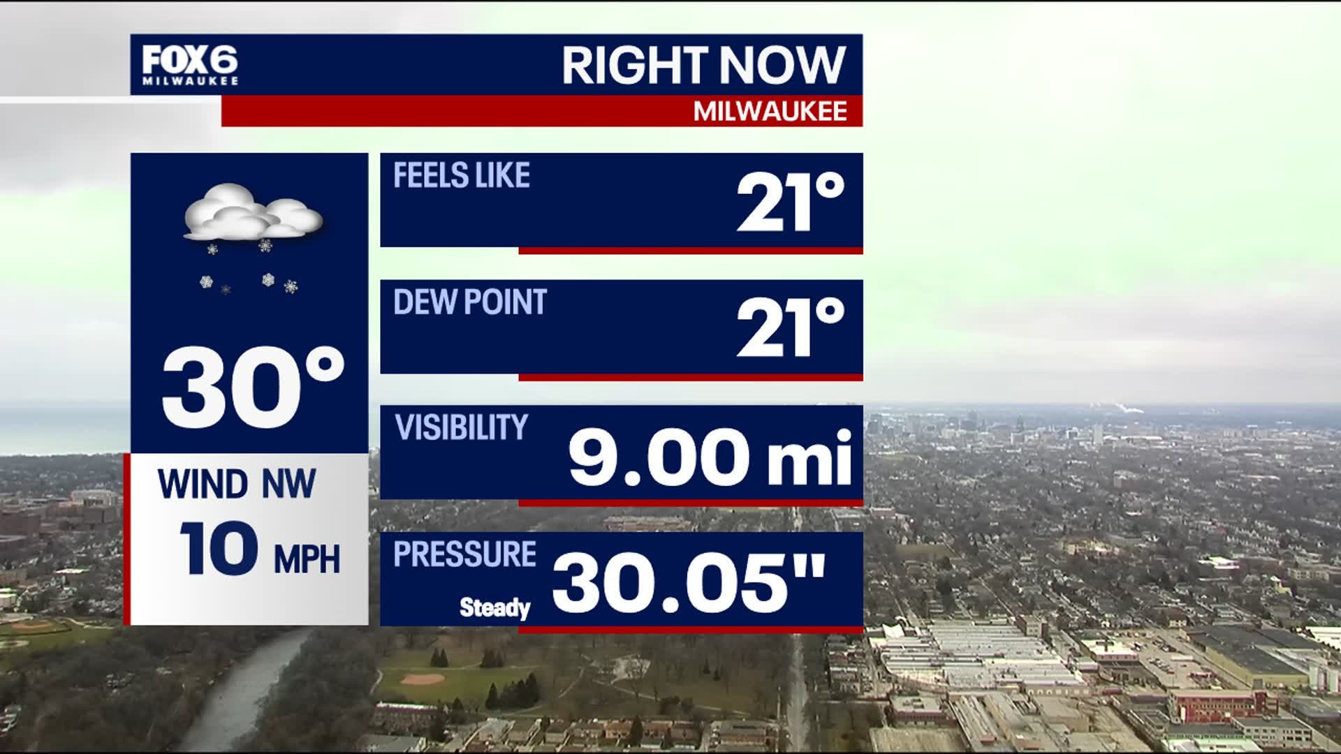
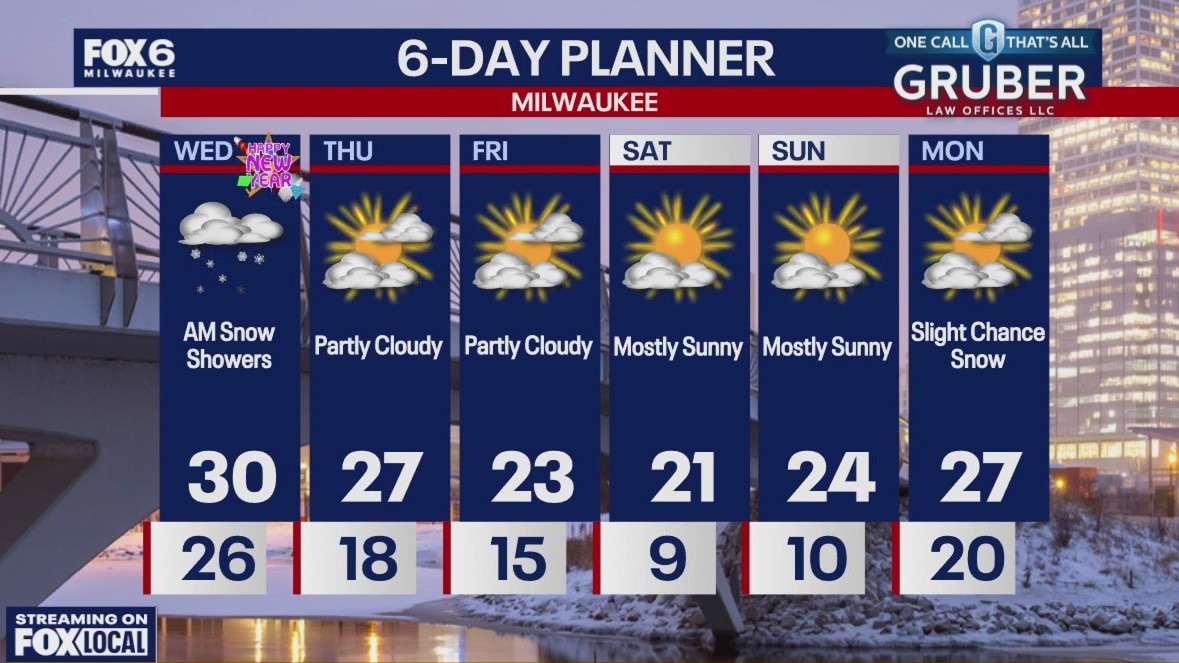
Drizzle, flurries, and a light snow shower early Wednesday morning to start 2025. High temps for the first day of the year will be near 30F. Clouds will decrease later today into tonight. Cold air remains in place for southeast Wisconsin for a long period of time. Highs will be in the 20s with lows dipping into the single digits by the end of the week.
Drizzle, flurries, and a light snow shower early Wednesday morning to start 2025. High temps for the first day of the year will be near 30F. Clouds will decrease later today into tonight. Cold air remains in place for southeast Wisconsin for a long period of time. Highs will be in the 20s with lows dipping into the single digits by the end of the week.
Weather Webcast with Chief Meteorologist Tom Wachs
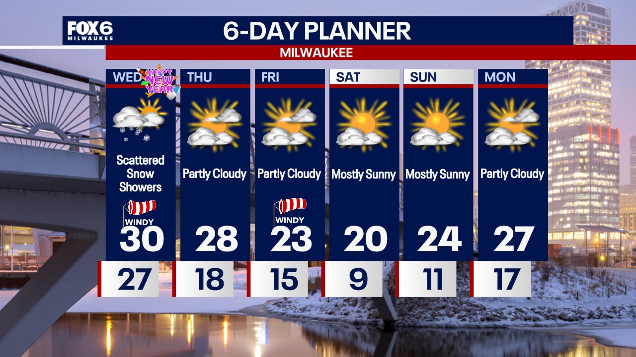
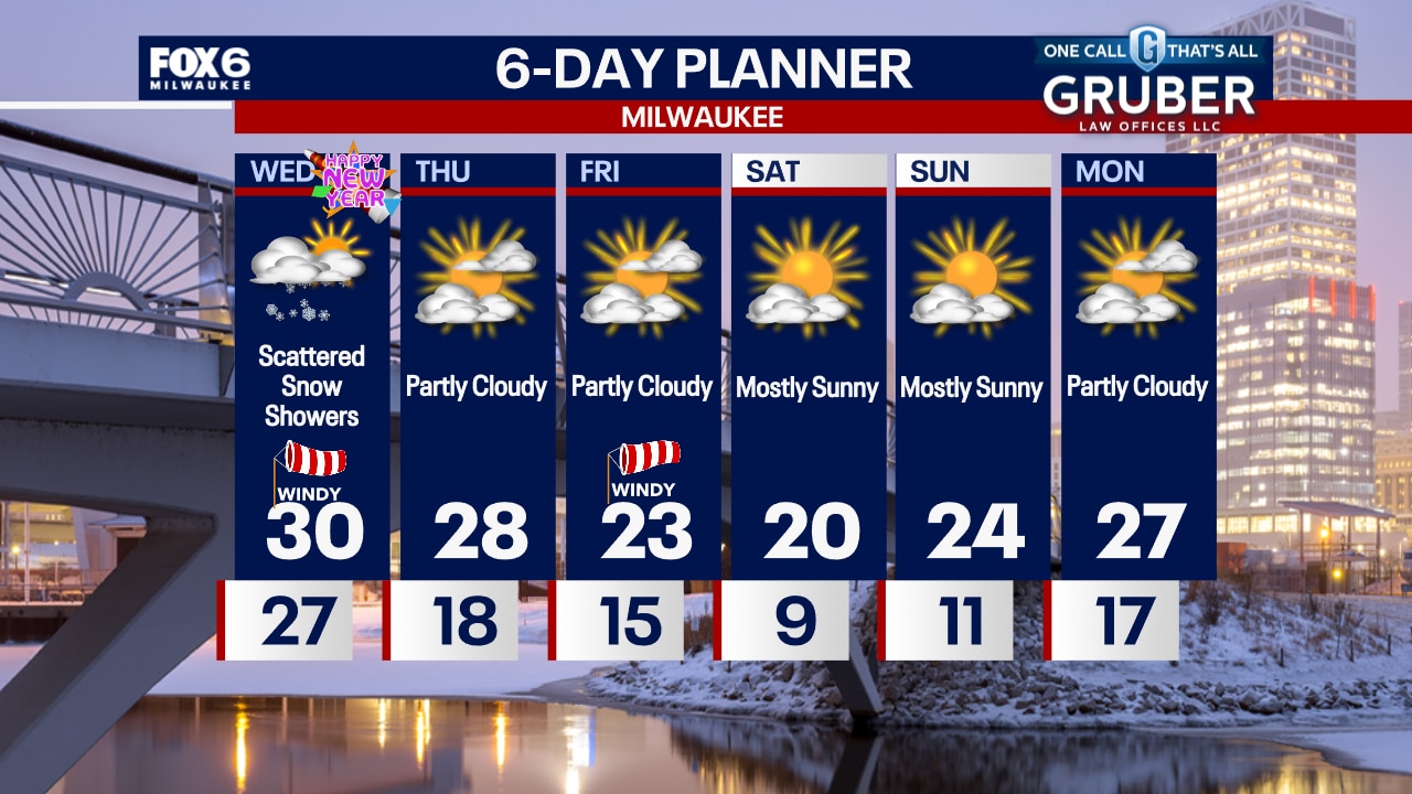
Areas of freezing drizzle and scattered snow showers will be possible overnight as we welcome 2025. Temperatures in the 20s overnight. Mostly cloudy with scattered snow showers on Wednesday. Windy with a high around 30 and afternoon wind chills in the teens.
Areas of freezing drizzle and scattered snow showers will be possible overnight as we welcome 2025. Temperatures in the 20s overnight. Mostly cloudy with scattered snow showers on Wednesday. Windy with a high around 30 and afternoon wind chills in the teens.
Weather Webcast with Chief Meteorologist Tom Wachs
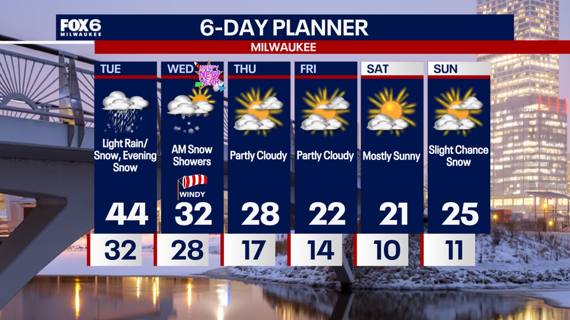
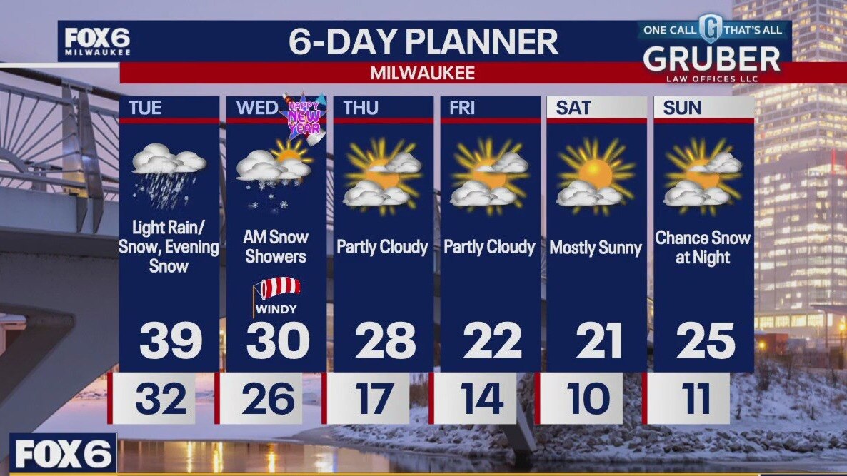
Scattered snow showers late this evening and overnight. Temperatures dropping below freezing. Scattered snow showers again on New Year's Day with a windy high around 30.
Scattered snow showers late this evening and overnight. Temperatures dropping below freezing. Scattered snow showers again on New Year's Day with a windy high around 30.
Weather Webcast with Stephanie Barichello
Light rain and snow continue this afternoon, then some spotty light snow expected tonight and tomorrow morning. There could be a dusting in spots, including on pavement, so be cautious traveling for New Year's Eve celebrations. Colder in the new year, with highs in the 20s and lows in the teens.
Light rain and snow continue this afternoon, then some spotty light snow expected tonight and tomorrow morning. There could be a dusting in spots, including on pavement, so be cautious traveling for New Year's Eve celebrations. Colder in the new year, with highs in the 20s and lows in the teens.
Weather webcast with Lisa Michaels
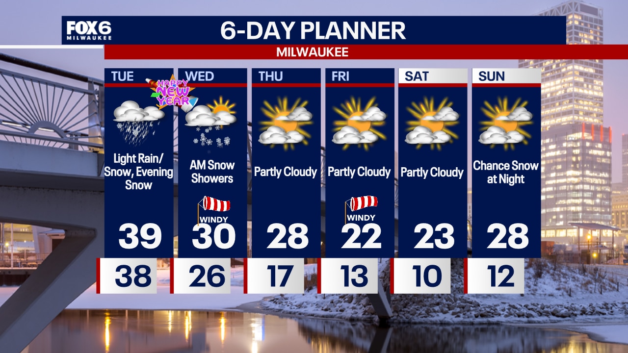
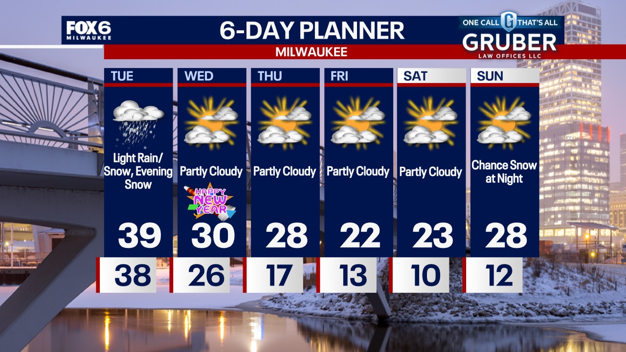
Rain/snow mix near the Wisconsin-Illinois border in the morning. This will spread north through the day and changing over all to snow by tonight. A dusting to a tenth of an inch expected. Highs in the upper 30s Tuesday with northeast winds 10-15mph and increasing over night. Morning snow showers for the first day of 2025. Decreasing clouds. Highs back below freezing Wednesday through next week. Long term, sub-freezing temps will be the new normal.
Rain/snow mix near the Wisconsin-Illinois border in the morning. This will spread north through the day and changing over all to snow by tonight. A dusting to a tenth of an inch expected. Highs in the upper 30s Tuesday with northeast winds 10-15mph and increasing over night. Morning snow showers for the first day of 2025. Decreasing clouds. Highs back below freezing Wednesday through next week. Long term, sub-freezing temps will be the new normal.
Weather Webcast with Chief Meteorologist Tom Wachs
Light rain/snow showers possible overnight into Tuesday. Highs in the 30s on Tuesday. A dusting of snow is possible for New Year's Eve on Tuesday night. A few slick spots are possible.
Light rain/snow showers possible overnight into Tuesday. Highs in the 30s on Tuesday. A dusting of snow is possible for New Year's Eve on Tuesday night. A few slick spots are possible.
Weather Webcast with Chief Meteorologist Tom Wachs
Light rain/snow showers are possible overnight and off-and-on on Tuesday. Temperatures in the 30s tonight and low 40s on Tuesday. A dusting of snow is possible on Tuesday night for New Year's Eve.
Light rain/snow showers are possible overnight and off-and-on on Tuesday. Temperatures in the 30s tonight and low 40s on Tuesday. A dusting of snow is possible on Tuesday night for New Year's Eve.