

Weather Webcast with Holly Baker
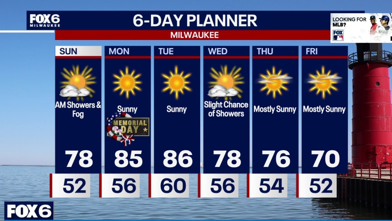
Warmer temperatures continue for Memorial Day.
Warmer temperatures continue for Memorial Day.
Weather webcast with Chief Meteorologist Rob Haswell
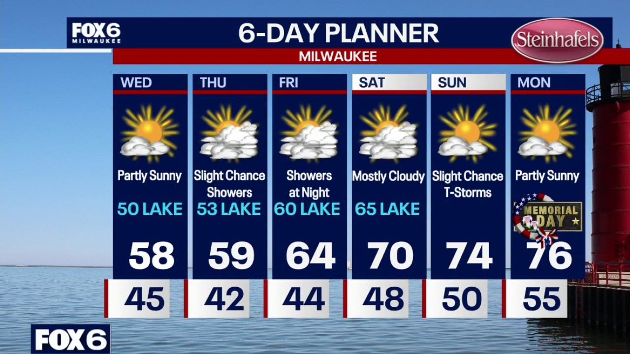
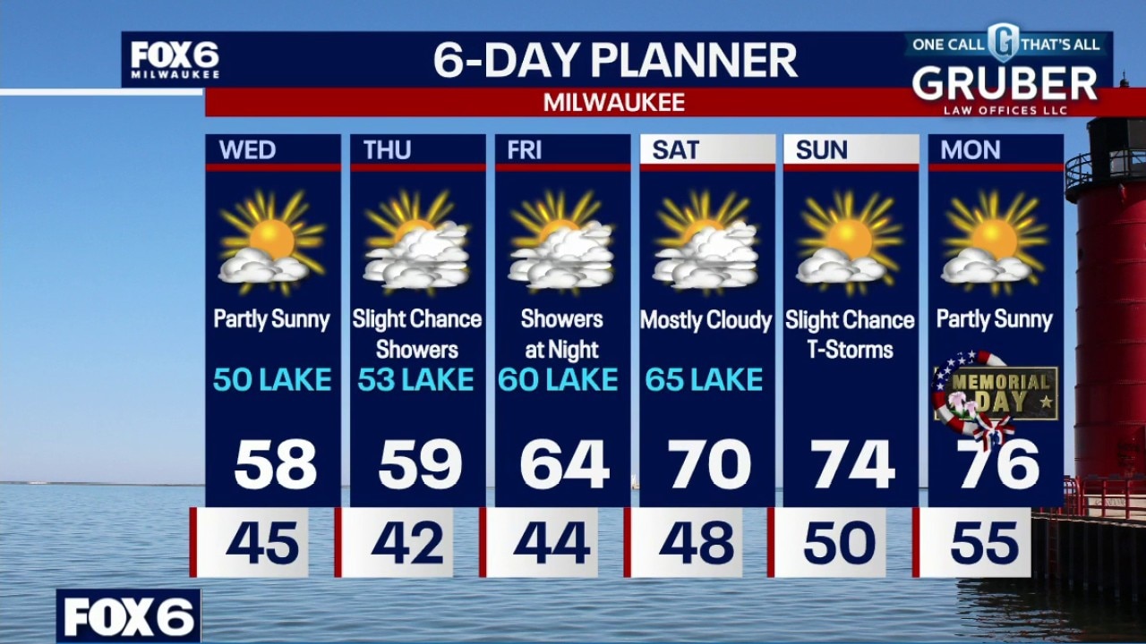
Southern Wisconsin is finally starting to turn the corner toward a much warmer pattern heading into Memorial Day weekend. Another cool day Saturday near Lake Michigan, inland areas should climb back to near 70 with scattered showers and a few isolated thunderstorms developing later this evening and overnight.
Southern Wisconsin is finally starting to turn the corner toward a much warmer pattern heading into Memorial Day weekend. Another cool day Saturday near Lake Michigan, inland areas should climb back to near 70 with scattered showers and a few isolated thunderstorms developing later this evening and overnight.
Weather Webcast with Holly Baker
Warmer temperatures are ahead.
Warmer temperatures are ahead.
Weather Webcast with Stephanie Barichello
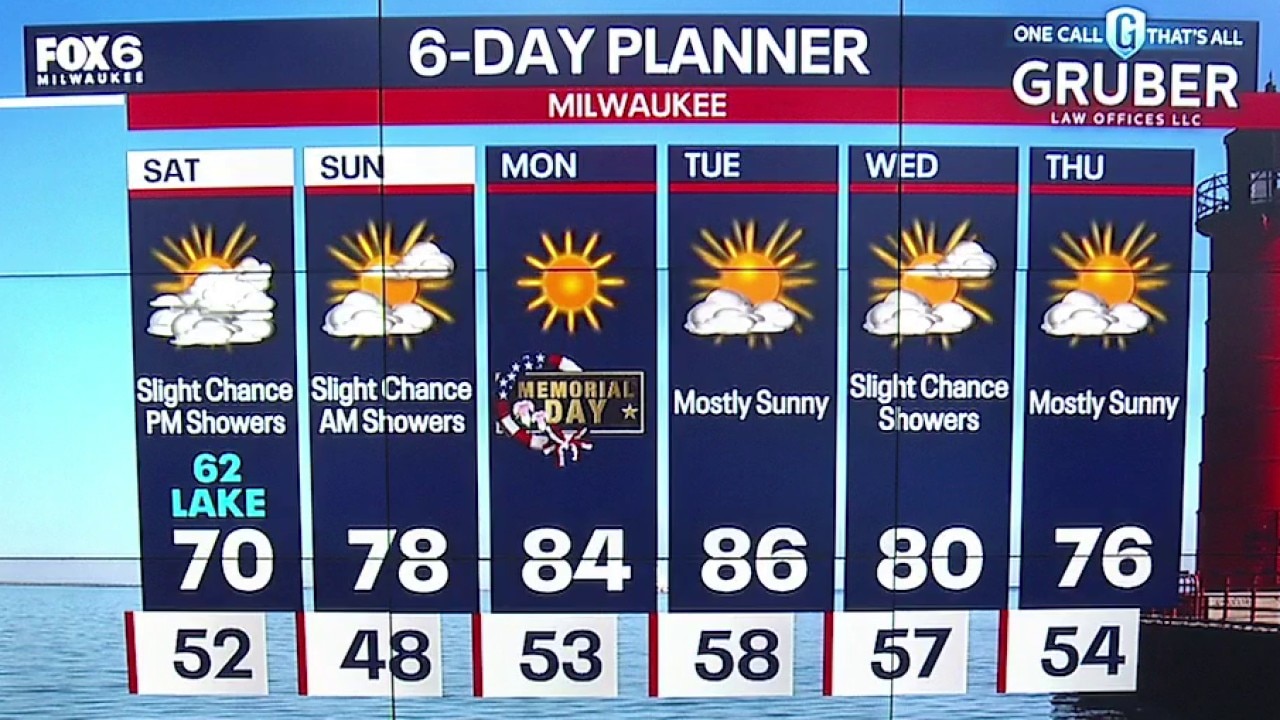
Warming up over the holiday weekend with slight chances of rain, mainly Saturday night through Sunday morning. Cooling a bit mid to late next week.
Warming up over the holiday weekend with slight chances of rain, mainly Saturday night through Sunday morning. Cooling a bit mid to late next week.
Weather webcast with Stephanie Barichello
We are still stuck in a cool easterly flow, keeping temperatures a little below average while clouds hang around for Friday. Dangerous swim conditions, with life-threatening currents and waves continue into Saturday along much of the Lake Michigan shoreline.
We are still stuck in a cool easterly flow, keeping temperatures a little below average while clouds hang around for Friday. Dangerous swim conditions, with life-threatening currents and waves continue into Saturday along much of the Lake Michigan shoreline.
Weather webcast with Rob Haswell
We are still stuck in a cool easterly flow, keeping temperatures a little below average while clouds hang around for Friday. Dangerous swim conditions, with life-threatening currents and waves continue into Saturday along much of the Lake Michigan shoreline.
We are still stuck in a cool easterly flow, keeping temperatures a little below average while clouds hang around for Friday. Dangerous swim conditions, with life-threatening currents and waves continue into Saturday along much of the Lake Michigan shoreline.

Weather Webcast with Chief Meteorologist Tom Wachs
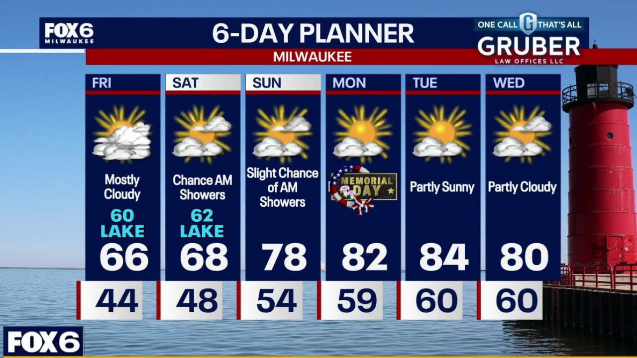
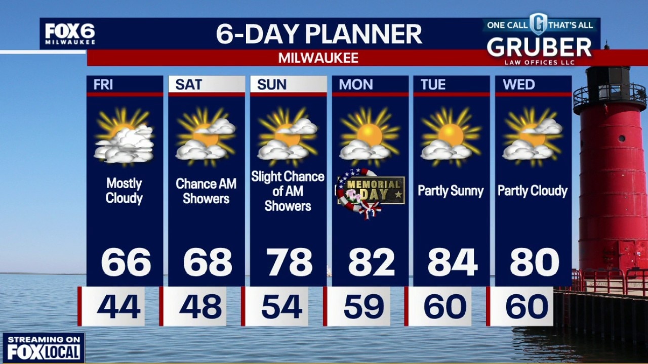
Mostly cloudy overnight with temperatures in the 40s. Mostly cloudy and windy on Friday with highs in the mid-60s inland, around 60 near the lake.
Mostly cloudy overnight with temperatures in the 40s. Mostly cloudy and windy on Friday with highs in the mid-60s inland, around 60 near the lake.
Weather Webcast with Chief Meteorologist Tom Wachs
Mostly cloudy overnight with temperatures in the 40s. Mostly cloudy and windy on Friday with highs in the mid-60s inland, around 60 near the lake.
Mostly cloudy overnight with temperatures in the 40s. Mostly cloudy and windy on Friday with highs in the mid-60s inland, around 60 near the lake.
Weather Webcast with Chief Meteorologist Tom Wachs
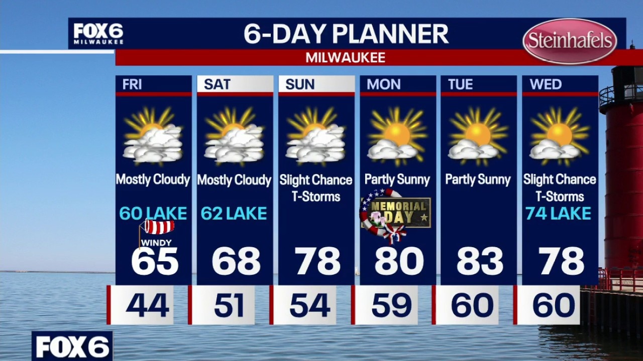
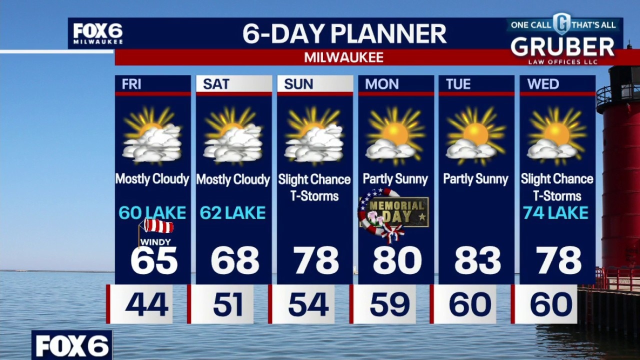
Mostly cloudy tonight with temperatures in the 40s near the lake, dropping into the 40s inland. Mostly cloudy and windy on Friday with highs in the mid-60s inland, around 60 near the lake.
Mostly cloudy tonight with temperatures in the 40s near the lake, dropping into the 40s inland. Mostly cloudy and windy on Friday with highs in the mid-60s inland, around 60 near the lake.
Weather webcast with meteorologist Holly Baker
Clouds hang tough Thursday and cooler north-east winds off Lake Michigan keep temperatures below normal, especially near the lakeshore. A stray sprinkle is possible but most of the area stays dry thanks to very dry low-level air.
Clouds hang tough Thursday and cooler north-east winds off Lake Michigan keep temperatures below normal, especially near the lakeshore. A stray sprinkle is possible but most of the area stays dry thanks to very dry low-level air.
Weather webcast with Rob Haswell
Clouds hang tough Thursday and cooler northeast winds off Lake Michigan keep temperatures below normal, especially near the lakeshore. A stray sprinkle is possible but most of the area stays dry thanks to very dry low-level air.
Clouds hang tough Thursday and cooler northeast winds off Lake Michigan keep temperatures below normal, especially near the lakeshore. A stray sprinkle is possible but most of the area stays dry thanks to very dry low-level air.
Weather Webcast with Chief Meteorologist Tom Wachs
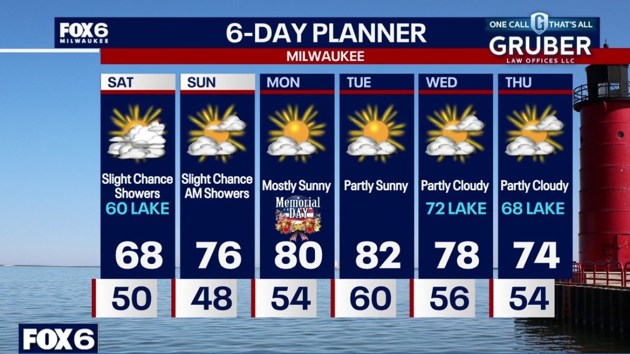
Cool overnight with temperatures dropping through the 40s. Mostly cloudy and cool again on Thursday with a few midday light rain showers possible. Highs in the low 50s near the lake, upper 50s inland. Mostly cloudy on Friday with a slight chance for rain showers. Highs in the upper 50s near the lake, low 60s inland.
Cool overnight with temperatures dropping through the 40s. Mostly cloudy and cool again on Thursday with a few midday light rain showers possible. Highs in the low 50s near the lake, upper 50s inland. Mostly cloudy on Friday with a slight chance for rain showers. Highs in the upper 50s near the lake, low 60s inland.
Weather Webcast with Chief Meteorologist Tom Wachs
Partly cloudy and crisp tonight with temperatures dropping through the 40s and settling in the low 40s by sunrise. Mostly cloudy and cool again on Thursday with a few midday light rain showers possible. Highs in the low 50s near the lake, upper 50s inland.
Partly cloudy and crisp tonight with temperatures dropping through the 40s and settling in the low 40s by sunrise. Mostly cloudy and cool again on Thursday with a few midday light rain showers possible. Highs in the low 50s near the lake, upper 50s inland.
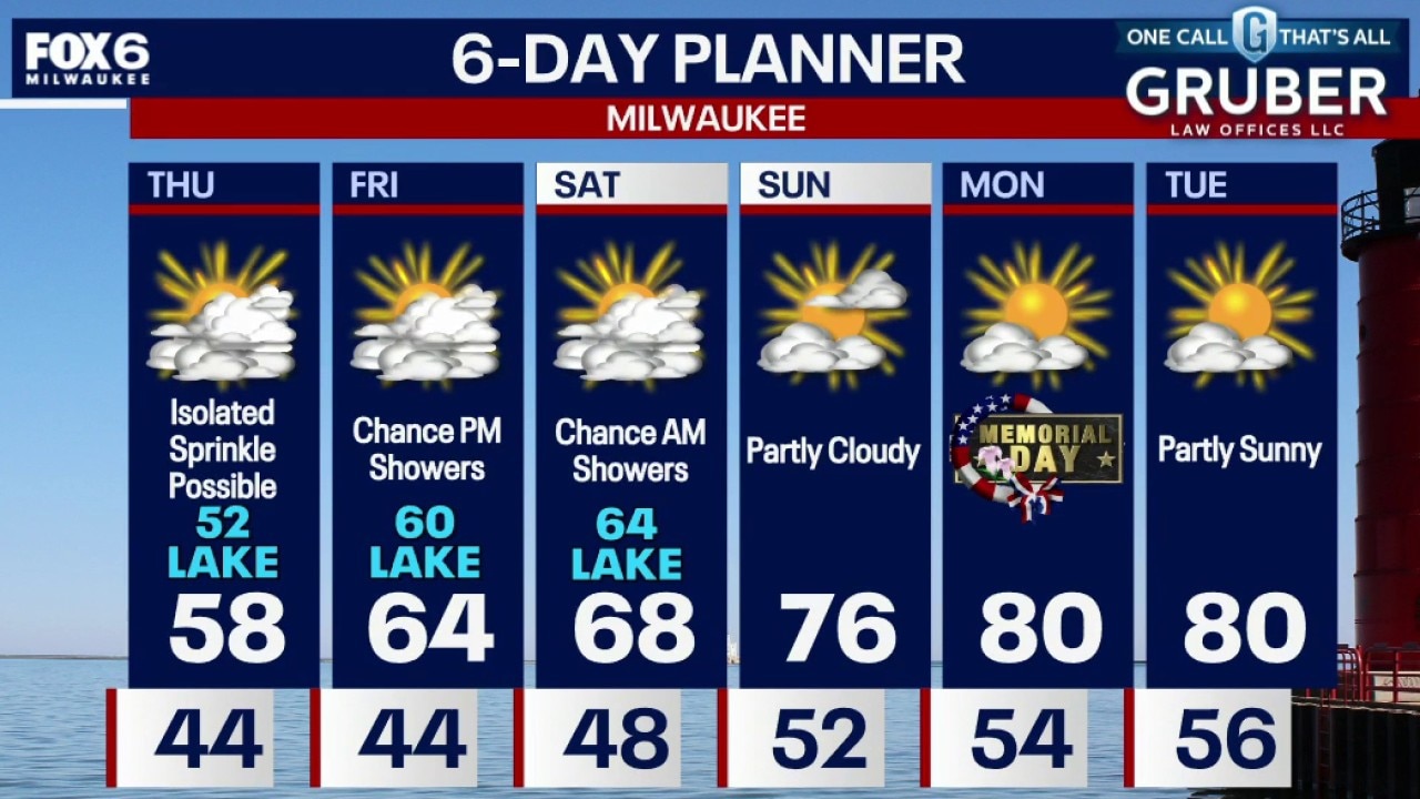
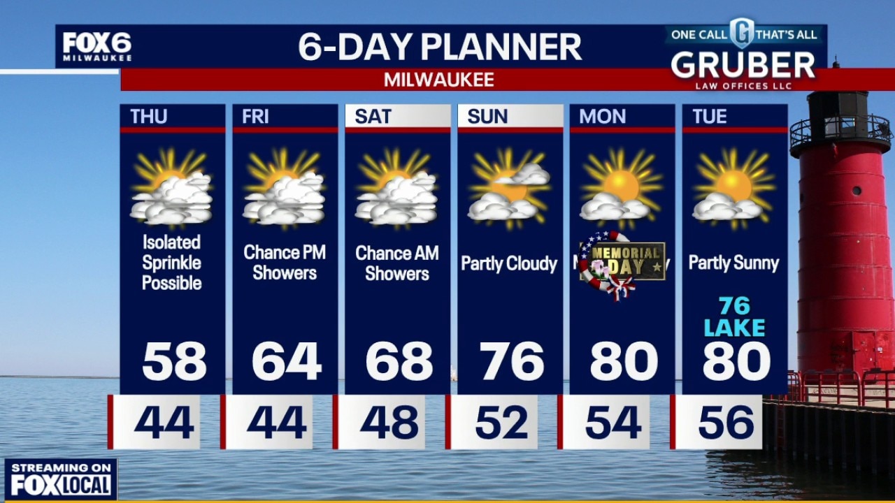
Weather Webcast with Stephanie Barichello
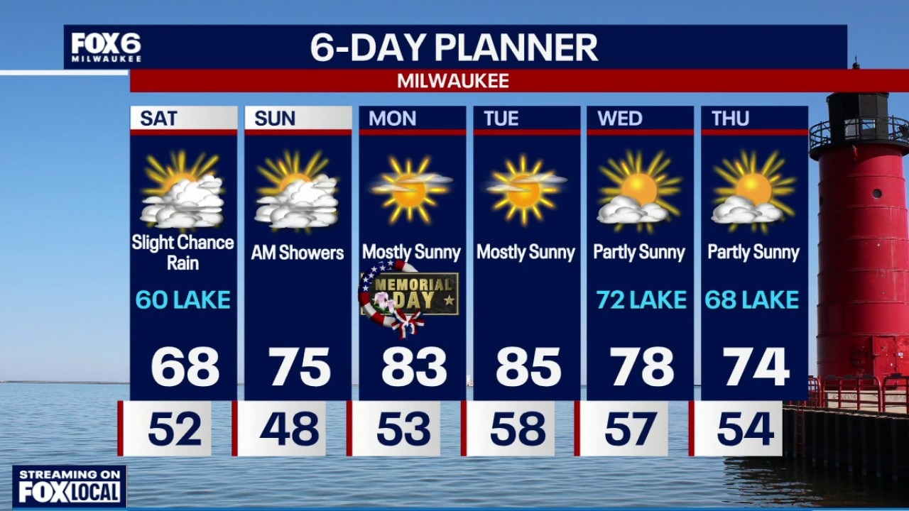
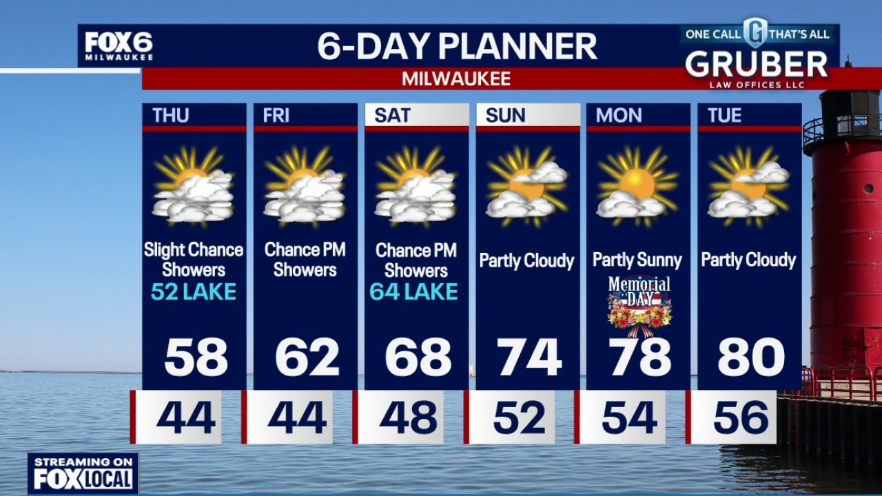
Cool tonight with lows in the 40s, then more 50s ahead Thursday with a slight chance of showers. Beginning to warm Friday and Saturday, then 70s return for the rest of the holiday weekend. There are slight chances of rain starting Friday night but Memorial Day itself looks dry and warm.
Cool tonight with lows in the 40s, then more 50s ahead Thursday with a slight chance of showers. Beginning to warm Friday and Saturday, then 70s return for the rest of the holiday weekend. There are slight chances of rain starting Friday night but Memorial Day itself looks dry and warm.
Weather webcast with Stephanie Barichello
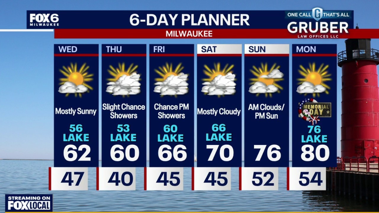
The midweek forecast keeps southern Wisconsin stuck in a cool onshore flow pattern, with highs mainly in the 50s near Lake Michigan and low 60s farther inland.
The midweek forecast keeps southern Wisconsin stuck in a cool onshore flow pattern, with highs mainly in the 50s near Lake Michigan and low 60s farther inland.
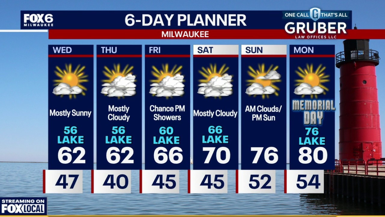
Weather webcast with Rob Haswell
The midweek forecast keeps southern Wisconsin stuck in a cool onshore flow pattern, with highs mainly in the 50s near Lake Michigan and low 60s farther inland.
The midweek forecast keeps southern Wisconsin stuck in a cool onshore flow pattern, with highs mainly in the 50s near Lake Michigan and low 60s farther inland.
Weather Webcast with Chief Meteorologist Tom Wachs
Gradual clearing overnight with temperatures dropping into the 40s. Partly sunny and brisk on Wednesday. Highs in the upper 50s inland, around 50 near the lake. Chilly again on Thursday with morning lows in the low 40s and highs in the 50s, coolest near the lake. Mostly cloudy on Thursday with a slight chance for a rain shower.
Gradual clearing overnight with temperatures dropping into the 40s. Partly sunny and brisk on Wednesday. Highs in the upper 50s inland, around 50 near the lake. Chilly again on Thursday with morning lows in the low 40s and highs in the 50s, coolest near the lake. Mostly cloudy on Thursday with a slight chance for a rain shower.
Weather Webcast with Chief Meteorologist Tom Wachs
Gradual clearing tonight with temperatures dropping into the 50s this evening and 40s overnight.
Gradual clearing tonight with temperatures dropping into the 50s this evening and 40s overnight.
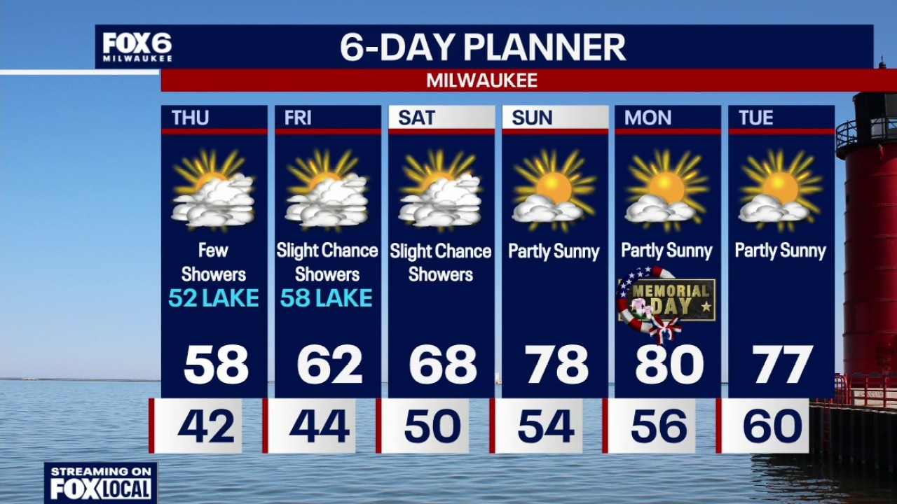
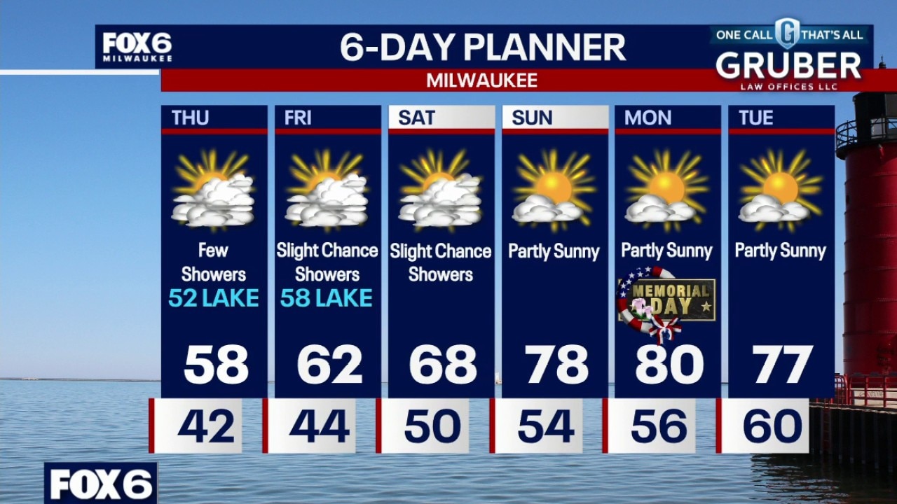
Weather webcast with Stephanie Barichello
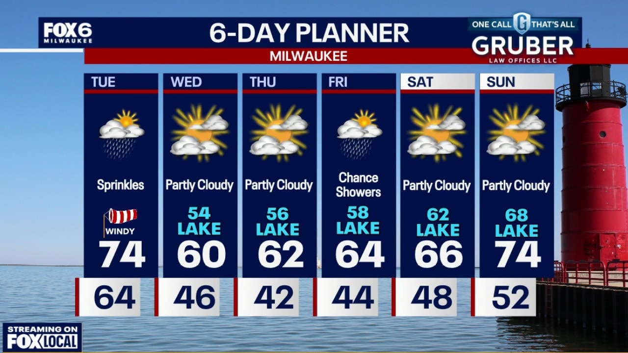
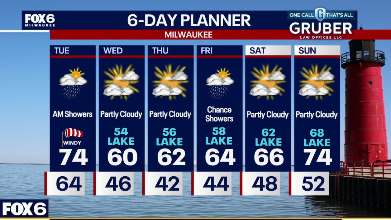
Another round of showers and a few thunderstorms moving through the area Tuesday morning. A couple stronger storms cannot be ruled out, but the overall severe weather threat looks very limited.
Another round of showers and a few thunderstorms moving through the area Tuesday morning. A couple stronger storms cannot be ruled out, but the overall severe weather threat looks very limited.
Weather webcast with Rob Haswell
Another round of showers and a few thunderstorms moving through the area Tuesday morning. A couple stronger storms cannot be ruled out, but the overall severe weather threat looks very limited.
Another round of showers and a few thunderstorms moving through the area Tuesday morning. A couple stronger storms cannot be ruled out, but the overall severe weather threat looks very limited.