


Weather webcast with Stephanie Barichello
Sunny and much colder for the start to astronomical winter today! Temperatures will reach into the 20s this afternoon.
Sunny and much colder for the start to astronomical winter today! Temperatures will reach into the 20s this afternoon.

Weather webcast with Holly Baker
Skies will be clear tonight with breezy winds. Temperatures will be cooler in the 20s on Sunday with mostly sunny skies. Another chance for light snow will be likely on Monday.
Skies will be clear tonight with breezy winds. Temperatures will be cooler in the 20s on Sunday with mostly sunny skies. Another chance for light snow will be likely on Monday.

Weather webcast with Stephanie Barichello
Mostly cloudy and windy today with a few flurries or light snow showers through midday. Temperatures reach into the middle 30s. Clearing skies this evening and overnight with dropping temperatures back into the low teens by Sunday morning.
Mostly cloudy and windy today with a few flurries or light snow showers through midday. Temperatures reach into the middle 30s. Clearing skies this evening and overnight with dropping temperatures back into the low teens by Sunday morning.

Weather webcast with Holly Baker
Skies will be mostly cloudy tonight with temperatures rising. There is a chance for a wintry mix that will transition over into snow on Saturday with a high near 40.
Skies will be mostly cloudy tonight with temperatures rising. There is a chance for a wintry mix that will transition over into snow on Saturday with a high near 40.

Weather webcast with Holly Baker
Skies will be mostly cloudy tonight with temperatures rising. There is a chance for a wintry mix that will transition over into snow on Saturday with a high near 40
Skies will be mostly cloudy tonight with temperatures rising. There is a chance for a wintry mix that will transition over into snow on Saturday with a high near 40

Weather webcast with Stephanie Barichello
Early morning flurries then some sunshine today, but much colder and windy. Temperatures will stay in the teens much of the day with colder wind chills, then climb overnight into the 20s.
Early morning flurries then some sunshine today, but much colder and windy. Temperatures will stay in the teens much of the day with colder wind chills, then climb overnight into the 20s.

Weather webcast with Tom Wachs
A flash freeze is likely tonight, meaning the temperature will drop below freezing this evening causing water from rain/snow melt to turn to ice. Snow showers are also possible, although the risk for "snow squalls" has decreased. Temperatures will drop into the teens overnight.
A flash freeze is likely tonight, meaning the temperature will drop below freezing this evening causing water from rain/snow melt to turn to ice. Snow showers are also possible, although the risk for "snow squalls" has decreased. Temperatures will drop into the teens overnight.
Weather webcast with Holly Baker
Rain showers expected this morning and midday with mild temperatures in the mid to upper 40s. Temperatures drop during the afternoon and rain will change to scattered snow showers.
Rain showers expected this morning and midday with mild temperatures in the mid to upper 40s. Temperatures drop during the afternoon and rain will change to scattered snow showers.

Weather webcast with Stephanie Barichello
Rain showers expected this morning and midday with mild temperatures in the mid to upper 40s.
Rain showers expected this morning and midday with mild temperatures in the mid to upper 40s.

Weather webcast with Stephanie Barichello
Partly cloudy morning with temperatures in the upper 20s to low 30s. Mostly sunny Wednesday with mild temperatures in the upper 30s.
Partly cloudy morning with temperatures in the upper 20s to low 30s. Mostly sunny Wednesday with mild temperatures in the upper 30s.

Weather webcast with Lisa Michaels
Partly cloudy morning with temperatures in the upper 20s to low 30s. Mostly sunny Wednesday with mild temperatures in the upper 30s.
Partly cloudy morning with temperatures in the upper 20s to low 30s. Mostly sunny Wednesday with mild temperatures in the upper 30s.

Weather Webcast with Chief Meteorologist Tom Wachs
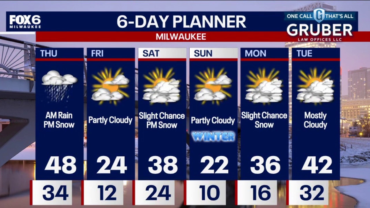
Partly cloudy and mild overnight with temperatures in the 20s to around 30 by sunrise. Partly sunny and mild again on Wednesday with highs in the upper 30s. Rain will move in on Thursday morning with a windy high in the low 40s. Rain will mix with or change to snow as the system moves out on Thursday night. Little, if any accumulation. BUT a freeze/icy conditions likely Thursday night as temperatures drop below freezing. Very cold on Friday, back up to 40 on Saturday and 20s again on Sunday. No major storms through Christmas with temperatures in the 30s/40s.
Partly cloudy and mild overnight with temperatures in the 20s to around 30 by sunrise. Partly sunny and mild again on Wednesday with highs in the upper 30s. Rain will move in on Thursday morning with a windy high in the low 40s. Rain will mix with or change to snow as the system moves out on Thursday night. Little, if any accumulation. BUT a freeze/icy conditions likely Thursday night as temperatures drop below freezing. Very cold on Friday, back up to 40 on Saturday and 20s again on Sunday. No major storms through Christmas with temperatures in the 30s/40s.

Tuesday evening weathercast
Rain and snow are likely on Thursday ahead of another cooldown, with a fairly sunny start to the winter.
Rain and snow are likely on Thursday ahead of another cooldown, with a fairly sunny start to the winter.

Tuesday evening weathercast
Southern Wisconsin will see milder weather through early Thursday, with highs in the mid to upper 30s and breezy southwest winds Tuesday and Wednesday. Dry conditions continue through Wednesday evening.
Southern Wisconsin will see milder weather through early Thursday, with highs in the mid to upper 30s and breezy southwest winds Tuesday and Wednesday. Dry conditions continue through Wednesday evening.

Weather webcast with Lisa Michaels
Southern Wisconsin will see milder weather through early Thursday, with highs in the mid to upper 30s and breezy southwest winds Tuesday and Wednesday. Dry conditions continue through Wednesday evening.
Southern Wisconsin will see milder weather through early Thursday, with highs in the mid to upper 30s and breezy southwest winds Tuesday and Wednesday. Dry conditions continue through Wednesday evening.

Weather webcast with Holly Baker
Partly cloudy and mild tonight with temperatures in the 30s. Temperatures will drop into the 20s to around 30 by sunrise.
Partly cloudy and mild tonight with temperatures in the 30s. Temperatures will drop into the 20s to around 30 by sunrise.

Weather webcast with Rob Haswell
Southern Wisconsin will see milder weather through early Thursday, with highs in the mid to upper 30s and breezy southwest winds Tuesday and Wednesday. Dry conditions continue through Wednesday evening.
Southern Wisconsin will see milder weather through early Thursday, with highs in the mid to upper 30s and breezy southwest winds Tuesday and Wednesday. Dry conditions continue through Wednesday evening.

Weather Webcast with Chief Meteorologist Tom Wachs
Clear and cold overnight with temperatures in the teens. Increasing clouds on Tuesday with drizzle possible by afternoon. Blustery with highs above freezing, in the mid-30s.
Clear and cold overnight with temperatures in the teens. Increasing clouds on Tuesday with drizzle possible by afternoon. Blustery with highs above freezing, in the mid-30s.

Weather Webcast with Chief Meteorologist Tom Wachs
Clearing and cold tonight with temperatures dipping into the low teens by sunrise. Increasing clouds on Tuesday with some afternoon drizzle possible. It will be the first day above freezing in six days with highs in the mid-30s.
Clearing and cold tonight with temperatures dipping into the low teens by sunrise. Increasing clouds on Tuesday with some afternoon drizzle possible. It will be the first day above freezing in six days with highs in the mid-30s.