


Weather Webcast with Tom Wachs
Rainy and windy overnight with temperatures around 35-40. More rain and wind on Wednesday with highs in the low 40s. Rain will change to sleet and snow late Wednesday evening.
Rainy and windy overnight with temperatures around 35-40. More rain and wind on Wednesday with highs in the low 40s. Rain will change to sleet and snow late Wednesday evening.

Weather Webcast with Tom Wachs
Rainy and windy late this evening and overnight. The rain will get lighter midday Wednesday before picking up Wed. evening. Heavy snow late Wednesday night.
Rainy and windy late this evening and overnight. The rain will get lighter midday Wednesday before picking up Wed. evening. Heavy snow late Wednesday night.

Weather Webcast with Meteorologist Stephanie Barichello
Windy today with evening rain showers that'll last on and off throughout Wednesday. Slushy snow expected Wednesday night with a few inches of accumulation possible by Thursday morning. Light snow will then be possible Friday and Saturday.
Windy today with evening rain showers that'll last on and off throughout Wednesday. Slushy snow expected Wednesday night with a few inches of accumulation possible by Thursday morning. Light snow will then be possible Friday and Saturday.

Weather webcast with Rob Haswell
Cloudy and mild today ahead of a strong low moving our way from Colorado today. Temperatures will warm to the low 40s today and stay in the mid to upper 30s even overnight. A strong SE wind will gust to near 40mph today and tomorrow as the strong low moves into the area. We can expect rain starting late this evening an continuing overnight and through Wednesday with well over an inch of rain is possible through late Wednesday.
Cloudy and mild today ahead of a strong low moving our way from Colorado today. Temperatures will warm to the low 40s today and stay in the mid to upper 30s even overnight. A strong SE wind will gust to near 40mph today and tomorrow as the strong low moves into the area. We can expect rain starting late this evening an continuing overnight and through Wednesday with well over an inch of rain is possible through late Wednesday.

Weather Webcast with Tom Wachs
Cloudy skies overnight with temperatures in the 30s. The wind will pick up on Tuesday with highs around 40. Steady rain moves in Tuesday night into Wednesday.
Cloudy skies overnight with temperatures in the 30s. The wind will pick up on Tuesday with highs around 40. Steady rain moves in Tuesday night into Wednesday.

Weather Webcast with Tom Wachs
Cloudy tonight with temperatures in the 30s. Windy on Tuesday with a few afternoon light rain showers. Steady rain moves in later Tuesday night & Wednesday.
Cloudy tonight with temperatures in the 30s. Windy on Tuesday with a few afternoon light rain showers. Steady rain moves in later Tuesday night & Wednesday.
Weather Webcast with Meteorologist Stephanie Barichello
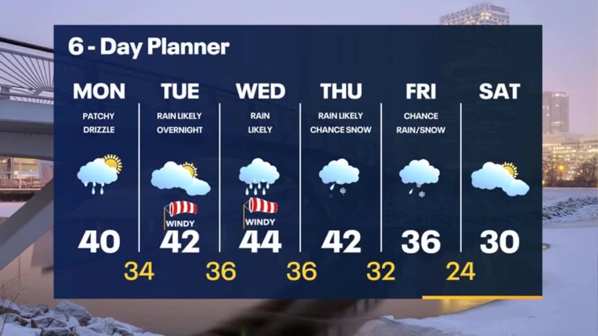
Patchy light rain and snow will continue at times this afternoon then drying overnight. Windy Tuesday with a soaking rain at night, then scattered rain showers on Wednesday. Rain/snow mix Thursday then mainly light snow on Friday as this big system exits.
Patchy light rain and snow will continue at times this afternoon then drying overnight. Windy Tuesday with a soaking rain at night, then scattered rain showers on Wednesday. Rain/snow mix Thursday then mainly light snow on Friday as this big system exits.

Weather webcast with Rob Haswell
An elongated area of high pressure is stretched across our area today. This high isn't sufficient to clear us up but should mostly keep us dry. The east and northeast wind around this high-pressure ridge could generate some light drizzle as that wind comes in across Lake Michigan today. Highs today will be near 40 and we should warm a degree or two tomorrow ahead of a stronger storm low to our west.
An elongated area of high pressure is stretched across our area today. This high isn't sufficient to clear us up but should mostly keep us dry. The east and northeast wind around this high-pressure ridge could generate some light drizzle as that wind comes in across Lake Michigan today. Highs today will be near 40 and we should warm a degree or two tomorrow ahead of a stronger storm low to our west.

Weather Webcast with Meteorologist Eric Manges
FOX6 News at 9 offers the day's news. weather, and sports in southeast Wisconsin, the nation, and the world.
FOX6 News at 9 offers the day's news. weather, and sports in southeast Wisconsin, the nation, and the world.
Weather Webcast with Meteorologist Eric Manges
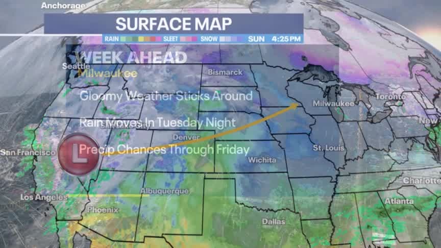
More gloom and rain is on the way this week
More gloom and rain is on the way this week

Weather Webcast with Meteorologist Lisa Michaels
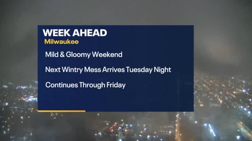
Periods of light drizzle and fog early Sunday morning. Otherwise, cloudy with highs in the mid to upper 30s again. A potent storm system will move in Tuesday bringing rain and breezy winds Tuesday and Wednesday. Late Wednesday we could see a switch over to a wintry mix heading into Thursday. Cold air on the back side will transition any precip to snow by Friday. Temperatures stay seasonable at least until the end of the week.
Periods of light drizzle and fog early Sunday morning. Otherwise, cloudy with highs in the mid to upper 30s again. A potent storm system will move in Tuesday bringing rain and breezy winds Tuesday and Wednesday. Late Wednesday we could see a switch over to a wintry mix heading into Thursday. Cold air on the back side will transition any precip to snow by Friday. Temperatures stay seasonable at least until the end of the week.
Weather Webcast with Meteorologist Eric Manges
Cloudy and dreary weather isn't going anywhere
Cloudy and dreary weather isn't going anywhere

Weather Webcast with Meteorologist Lisa Michaels
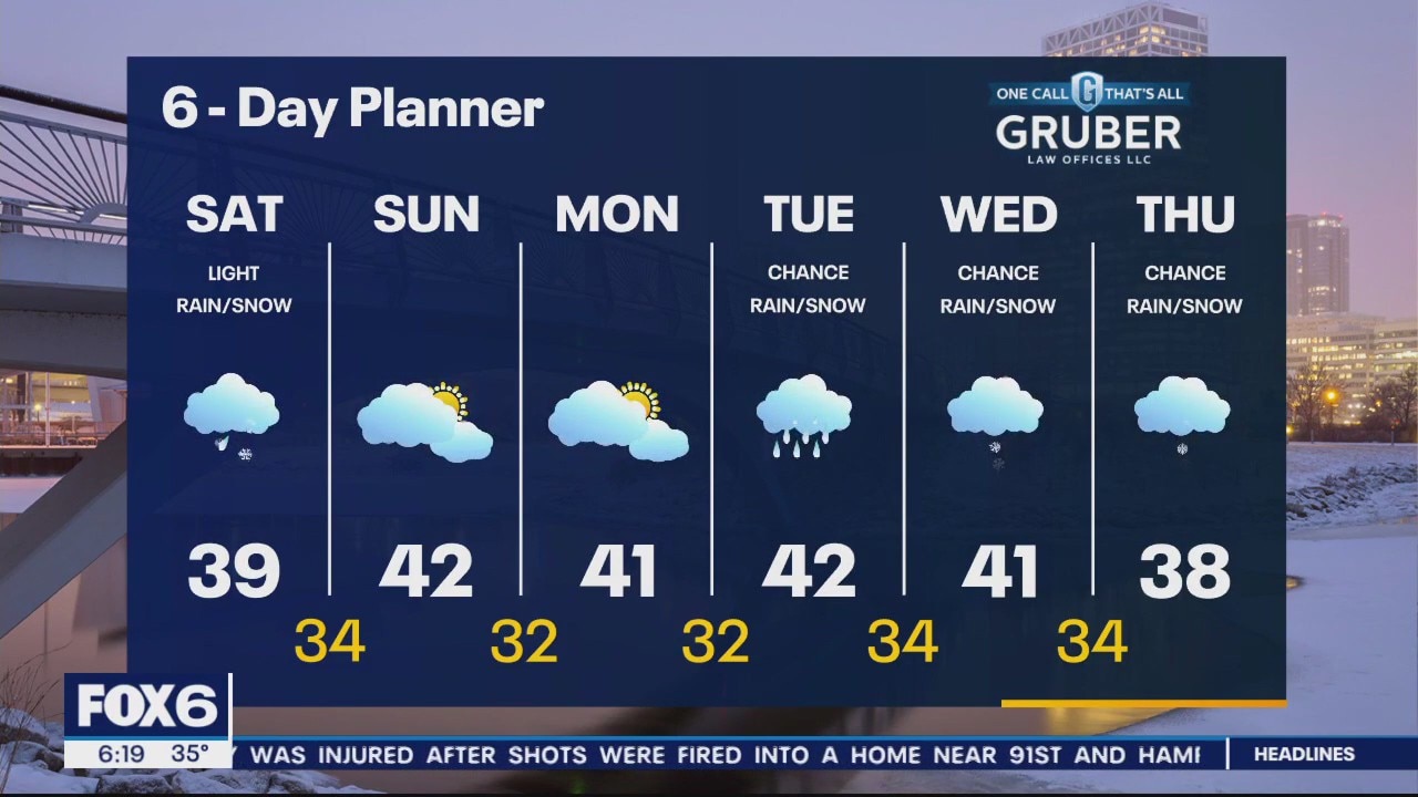
Mild temperatures will continue to help melt snow today. Highs will remain in the upper 30s with a chance for drizzle/fog/and a few snowflakes. High pressure moves in on Sunday causing for a drier day. Temperatures back into the lower 40s for high temperatures next week. Another system looks to bring us rain/snow late Tuesday into Thursday next week.
Mild temperatures will continue to help melt snow today. Highs will remain in the upper 30s with a chance for drizzle/fog/and a few snowflakes. High pressure moves in on Sunday causing for a drier day. Temperatures back into the lower 40s for high temperatures next week. Another system looks to bring us rain/snow late Tuesday into Thursday next week.
Weather Webcast with Meteorologist Eric Manges
FOX6 News at 6 offers the day's news, weather, and sports in southeast Wisconsin.
FOX6 News at 6 offers the day's news, weather, and sports in southeast Wisconsin.

Weather Webcast With Lisa Michaels
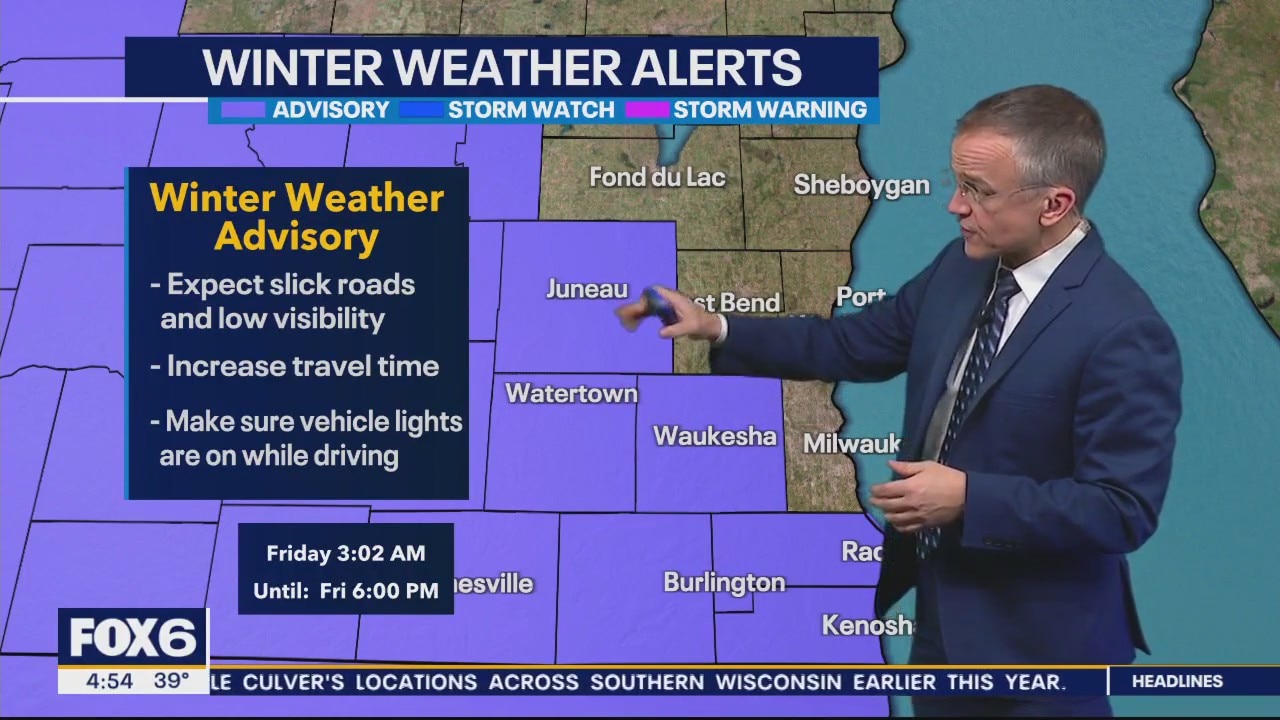
A Winter Weather Advisory is in effect for parts of our viewing area. A low passes over our area today bringing a swath of wet snow and wintry mix to our area. Some spots may see 2-5" of slushy wet accumulation. Conditions will improve later this afternoon and early evening. Afternoon temperatures will be in the mid to upper 30s and fall to the low to mid 30s overnight. Some icing is possible in spots that fall to or below freezing. A few more rain and snow showers are possible on Saturday with a mild high near 40. We dry up on Sunday and Monday and stay seasonally mild in the low 40s. Chances for rain and snow return but Tuesday and Wednesday.
A Winter Weather Advisory is in effect for parts of our viewing area. A low passes over our area today bringing a swath of wet snow and wintry mix to our area. Some spots may see 2-5" of slushy wet accumulation. Conditions will improve later this afternoon and early evening. Afternoon temperatures will be in the mid to upper 30s and fall to the low to mid 30s overnight. Some icing is possible in spots that fall to or below freezing. A few more rain and snow showers are possible on Saturday with a mild high near 40. We dry up on Sunday and Monday and stay seasonally mild in the low 40s. Chances for rain and snow return but Tuesday and Wednesday.
Weather webcast with Rob Haswell
A Winter Weather Advisory is in effect for parts of our viewing area. A low passes over our area today bringing a swath of wet snow and wintry mix to our area. Some spots may see 2-4" of slushy wet accumulation. Conditions will improve later this afternoon and early evening. Afternoon temperatures will be in the mid to upper 30s and fall to the low to mid 30s overnight. Some icing is possible in spots that fall to or below freezing.
A Winter Weather Advisory is in effect for parts of our viewing area. A low passes over our area today bringing a swath of wet snow and wintry mix to our area. Some spots may see 2-4" of slushy wet accumulation. Conditions will improve later this afternoon and early evening. Afternoon temperatures will be in the mid to upper 30s and fall to the low to mid 30s overnight. Some icing is possible in spots that fall to or below freezing.

Weather Webcast with Tom Wachs
Rain/snow starts mid-morning and changes to heavy snow in Milwaukee by midday. Expect low visibility, slow travel and 1-3" of accumulation. Heaviest 9am-2pm. Precipitation gradually tapers off later in the day.
Rain/snow starts mid-morning and changes to heavy snow in Milwaukee by midday. Expect low visibility, slow travel and 1-3" of accumulation. Heaviest 9am-2pm. Precipitation gradually tapers off later in the day.

Weather Webcast with Tom Wachs
Dry tonight with temperatures in the upper 20s to low 30s. Snow moves in on Friday morning and really picks up by midday. It will be tough to see on the roads in spots midday Friday.
Dry tonight with temperatures in the upper 20s to low 30s. Snow moves in on Friday morning and really picks up by midday. It will be tough to see on the roads in spots midday Friday.

Weather webcast with Rob Haswell
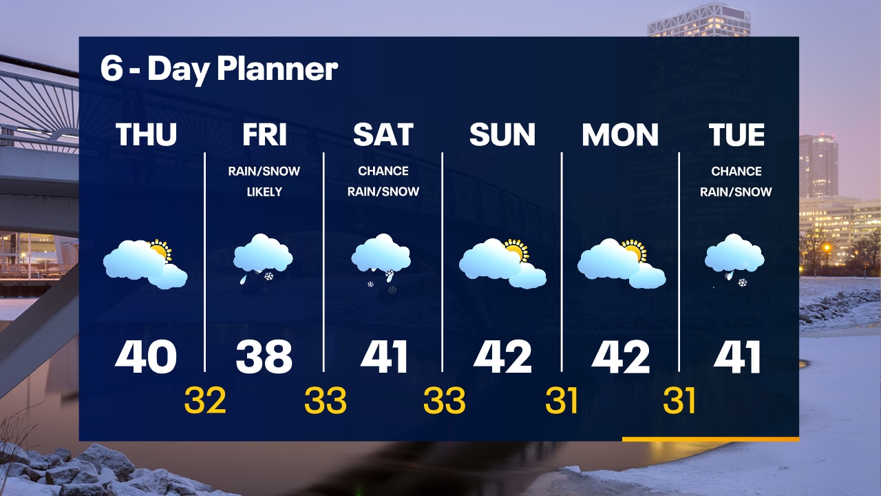
High pressure continues to dominate our forecast but without clearing our clouds. The position of the high creates a flow of drier air from the east today and tonight. Highs today will be near 40 and temperatures fall to the low 30s tonight. The flow of drier air will hold back the onset of precipitation until Friday morning and will help to minimize any accumulations. A slushy inch is possible in the metro areas with a lot of rain mixing in.
High pressure continues to dominate our forecast but without clearing our clouds. The position of the high creates a flow of drier air from the east today and tonight. Highs today will be near 40 and temperatures fall to the low 30s tonight. The flow of drier air will hold back the onset of precipitation until Friday morning and will help to minimize any accumulations. A slushy inch is possible in the metro areas with a lot of rain mixing in.
Weather Webcast with Tom Wachs
Cloudy skies overnight. Slim chance for a lake effect snow shower. Temperatures in the upper 20s. Mostly cloudy on Thursday with a high around 40. Rain/snow moves in Friday morning.
Cloudy skies overnight. Slim chance for a lake effect snow shower. Temperatures in the upper 20s. Mostly cloudy on Thursday with a high around 40. Rain/snow moves in Friday morning.