

Weather Webcast with Tom Wachs
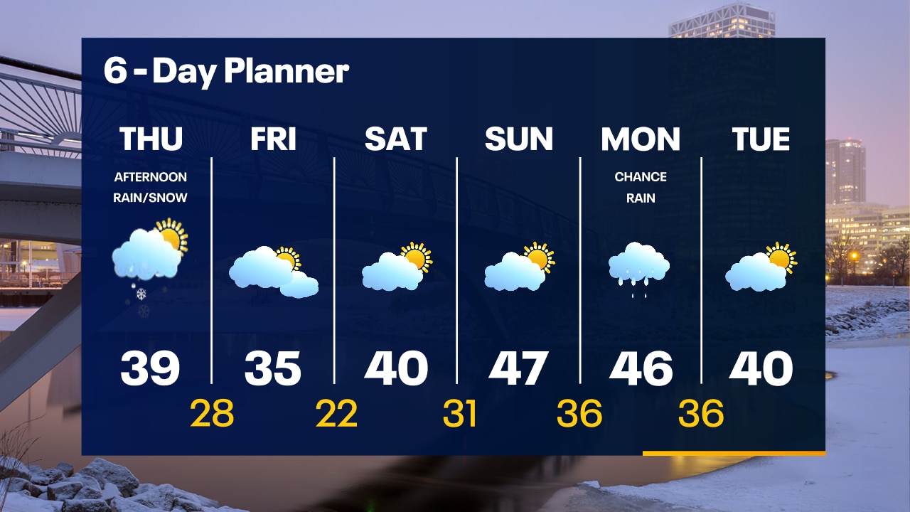
Areas of fog overnight with temperatures in the 30s. Mostly cloudy on Thursday and breezy. Scattered afternoon and evening rain/snow showers. Highs in the upper 30s.
Areas of fog overnight with temperatures in the 30s. Mostly cloudy on Thursday and breezy. Scattered afternoon and evening rain/snow showers. Highs in the upper 30s.

Weather Webcast with Tom Wachs
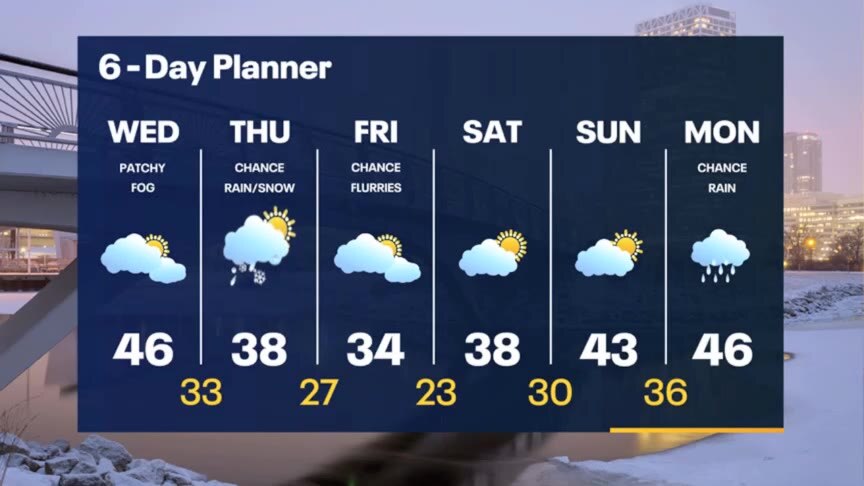
Patchy dense fog tonight with temperatures in the 30s. Mostly cloudy on Thursday with scattered afternoon and evening rain/snow showers. Highs in the upper 30s.
Patchy dense fog tonight with temperatures in the 30s. Mostly cloudy on Thursday with scattered afternoon and evening rain/snow showers. Highs in the upper 30s.
Weather Webcast with Meteorologist Stephanie Barichello
More fog and clouds this afternoon with temperatures in the 40s. Cooler Thursday with some light rain/snow possible at times then sunshine returns later Friday into the weekend. 40s are back by Sunday.
More fog and clouds this afternoon with temperatures in the 40s. Cooler Thursday with some light rain/snow possible at times then sunshine returns later Friday into the weekend. 40s are back by Sunday.

Weather webcast with Lisa Michaels
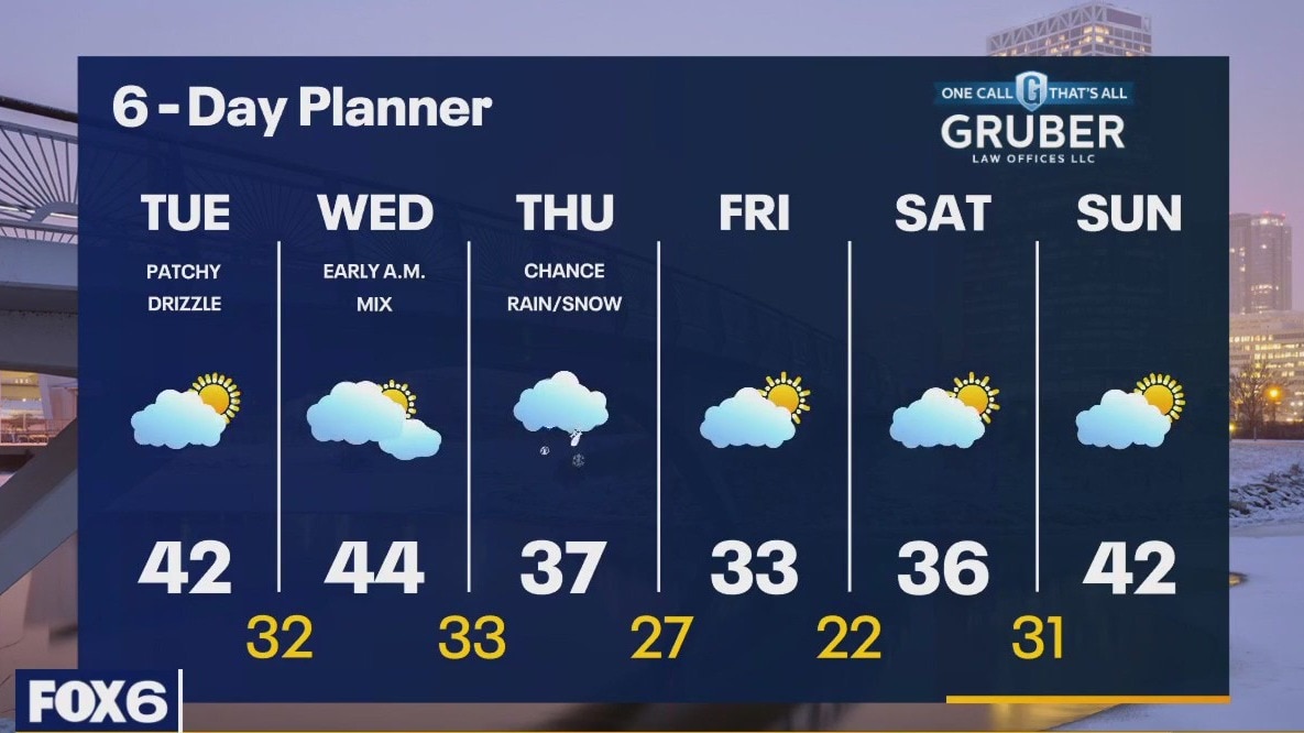
A wintry mix is possible this morning causing slick roads. Fog will also impact the morning commute. Mostly cloudy skies in the morning today turning to partly cloudy by the afternoon. Mild temps with highs in the 40s. A few rain/snow showers possible on Thursday. Highs in the upper 30s and breezy. Cooler air drives in behind a system on Friday with highs in the lower 30s, but warm temperatures return quickly by the weekend with partly cloudy skies.
A wintry mix is possible this morning causing slick roads. Fog will also impact the morning commute. Mostly cloudy skies in the morning today turning to partly cloudy by the afternoon. Mild temps with highs in the 40s. A few rain/snow showers possible on Thursday. Highs in the upper 30s and breezy. Cooler air drives in behind a system on Friday with highs in the lower 30s, but warm temperatures return quickly by the weekend with partly cloudy skies.
Weather Webcast with Tom Wachs
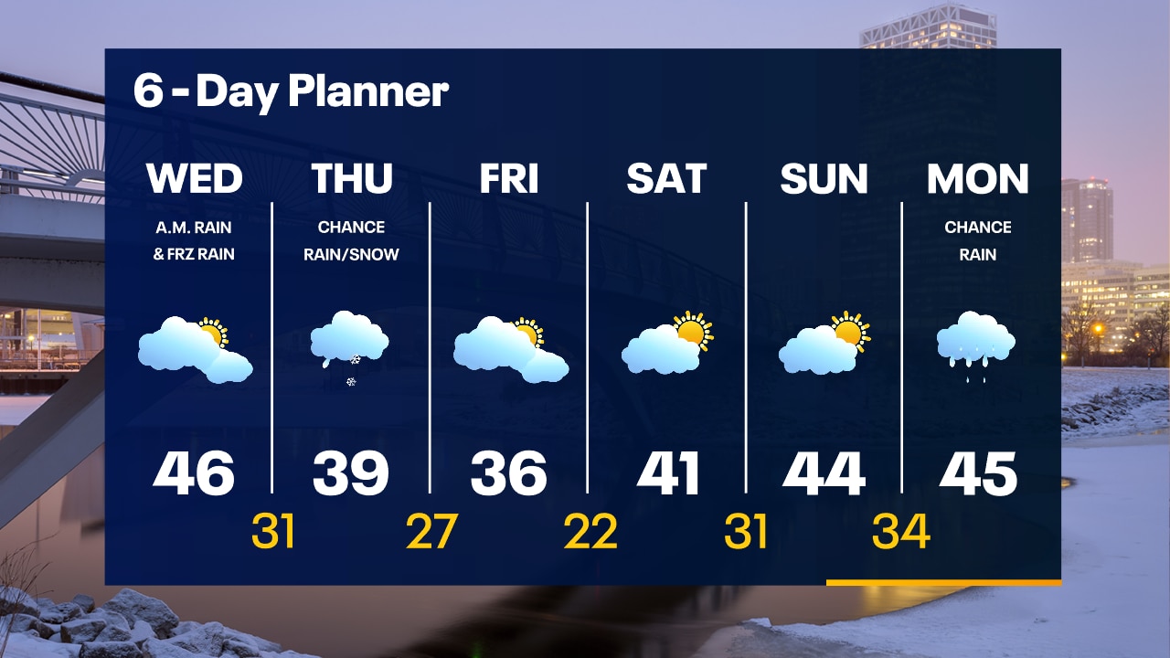
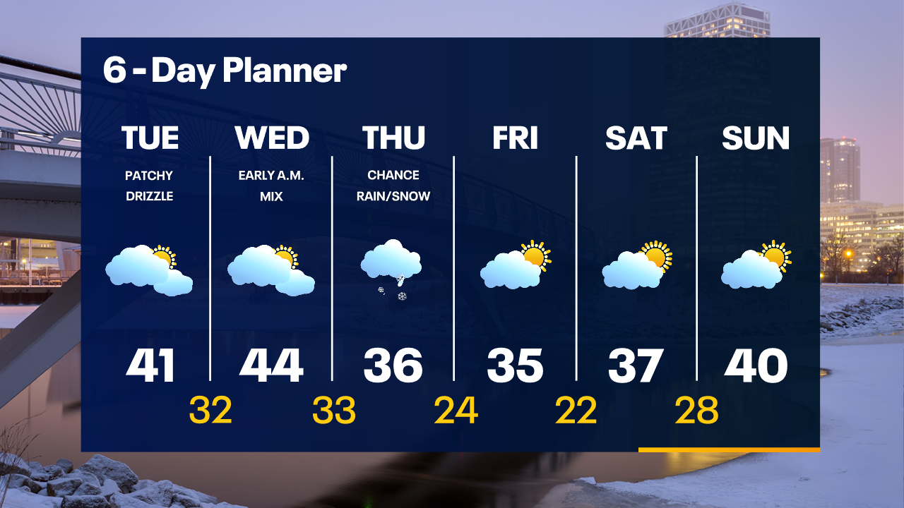
Slick roads possible overnight into Wednesday morning. Freezing fog and rain/freezing rain likely overnight. The precipitation ends by 8-9am. Mild on Wednesday afternoon with highs in the 40s.
Slick roads possible overnight into Wednesday morning. Freezing fog and rain/freezing rain likely overnight. The precipitation ends by 8-9am. Mild on Wednesday afternoon with highs in the 40s.
Weather Webcast with Tom Wachs
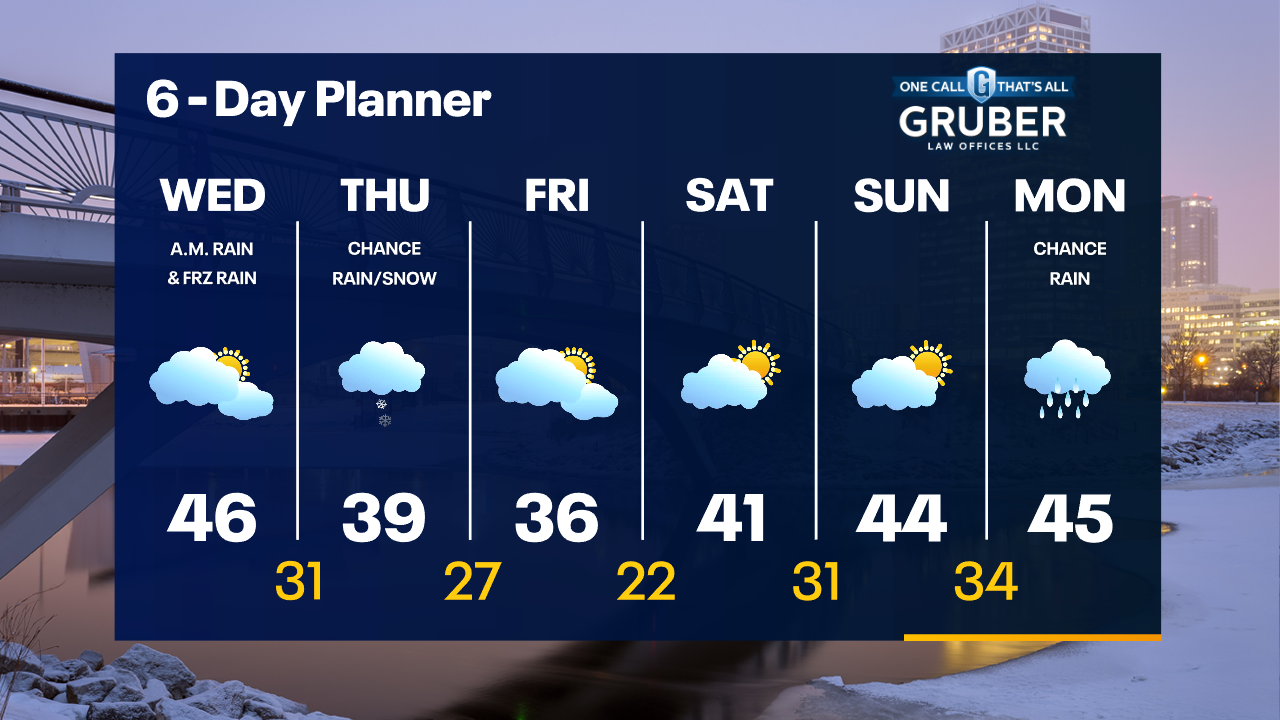
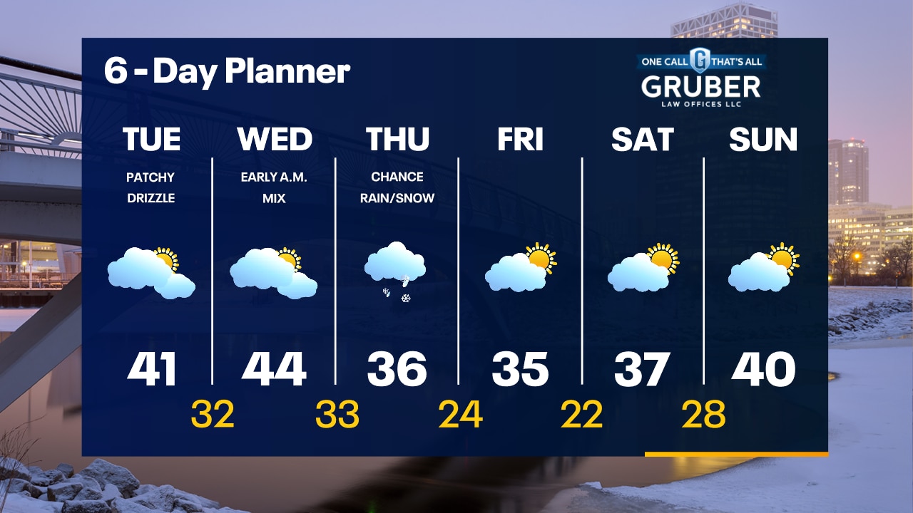
Patchy fog this evening with rain and freezing rain overnight. It could be slick in spots for the morning commute on Wednesday. Precipitation ends by 8-9am with a mild Wednesday afternoon expected.
Patchy fog this evening with rain and freezing rain overnight. It could be slick in spots for the morning commute on Wednesday. Precipitation ends by 8-9am with a mild Wednesday afternoon expected.

Weather Webcast with Meteorologist Stephanie Barichello
Some sun this afternoon then clouds return this evening along with another round of wintry mix Wednesday morning. Still a chance southern counties see more rain/snow Thursday then more sun over the weekend.
Some sun this afternoon then clouds return this evening along with another round of wintry mix Wednesday morning. Still a chance southern counties see more rain/snow Thursday then more sun over the weekend.
Weather webcast with Lisa Michaels
Fog, frost, and possible freezing drizzle this morning. Slick spots are more favorable for areas inland. Mostly cloudy to partly cloudy today with highs back in the lower 40s. Another chance of a light wintry mix heading into Wednesday morning. Temperatures cool down slightly near the end of the week but look to bounce back into the 40s by Sunday.
Fog, frost, and possible freezing drizzle this morning. Slick spots are more favorable for areas inland. Mostly cloudy to partly cloudy today with highs back in the lower 40s. Another chance of a light wintry mix heading into Wednesday morning. Temperatures cool down slightly near the end of the week but look to bounce back into the 40s by Sunday.
Weather Webcast with Tom Wachs
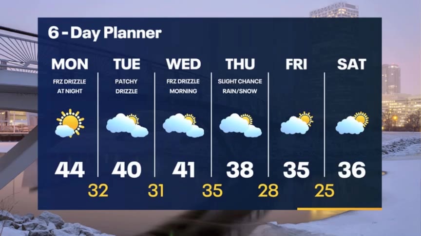
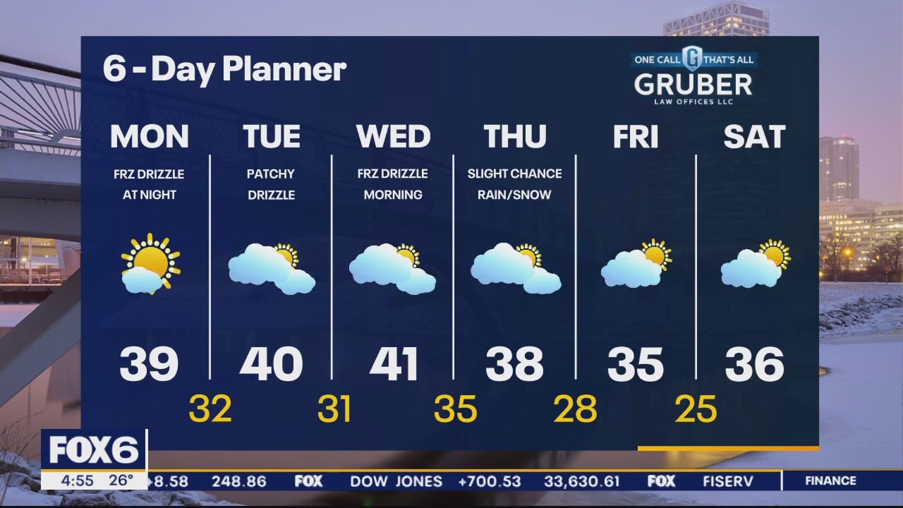
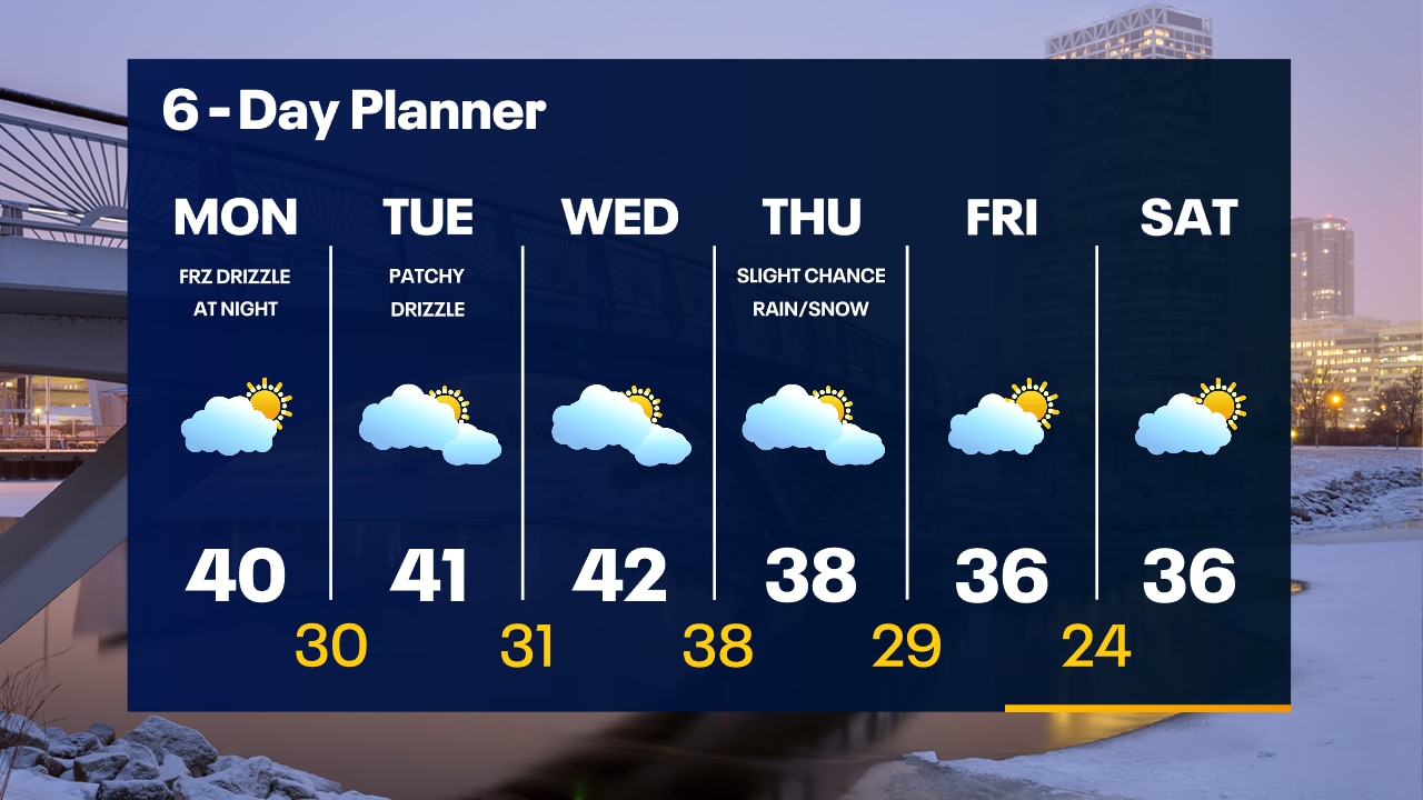
Patchy drizzle or freezing drizzle overnight. Temperatures in the 30s. Mostly cloudy and mild on Tuesday with areas of drizzle. Highs in the low 40s.
Patchy drizzle or freezing drizzle overnight. Temperatures in the 30s. Mostly cloudy and mild on Tuesday with areas of drizzle. Highs in the low 40s.
Weather Webcast with Tom Wachs
Patchy drizzle tonight with some freezing drizzle possible where temperatures drop below freezing. Temperatures will drop through the 30s tonight. Patchy drizzle on Tuesday with a high around 40.
Patchy drizzle tonight with some freezing drizzle possible where temperatures drop below freezing. Temperatures will drop through the 30s tonight. Patchy drizzle on Tuesday with a high around 40.
Weather Webcast with Meteorologist Stephanie Barichello
Sunny today then a chance for drizzle tonight and tomorrow. Still around 40 Tuesday and Wednesday. Some light wintry mix possible again Wednesday morning.
Sunny today then a chance for drizzle tonight and tomorrow. Still around 40 Tuesday and Wednesday. Some light wintry mix possible again Wednesday morning.
Weather webcast with Lisa Michaels
A crisp morning with temperatures in the 20s. Partly sunny on Monday with a mild high close to 40F. Freezing drizzle possible at night. Above average temperatures stay around this week in the upper 30s to lower 40s. Chance for rain/snow Thursday with cooler temps back by the weekend.
A crisp morning with temperatures in the 20s. Partly sunny on Monday with a mild high close to 40F. Freezing drizzle possible at night. Above average temperatures stay around this week in the upper 30s to lower 40s. Chance for rain/snow Thursday with cooler temps back by the weekend.
Weather Webcast with Tom Wachs
Clearing skies tonight and chilly with temperatures in the 20s. Partly sunny and warmer on Monday with a high around 40. Freezing drizzle is possible Monday night.
Clearing skies tonight and chilly with temperatures in the 20s. Partly sunny and warmer on Monday with a high around 40. Freezing drizzle is possible Monday night.

Weather Webcast with Meteorologist Lisa Michaels
Clouds stick around today with peaks of sunshine possible. Due to this highs will be in the lower 30s. Added clouds will keep temperatures in the mid to upper 20s tonight into Monday morning. Chances of precipitation late Thursday with light snow early Friday. Most of the impacts will be south and east. The long term temperature outlook keeps us well above average into the end of January.
Clouds stick around today with peaks of sunshine possible. Due to this highs will be in the lower 30s. Added clouds will keep temperatures in the mid to upper 20s tonight into Monday morning. Chances of precipitation late Thursday with light snow early Friday. Most of the impacts will be south and east. The long term temperature outlook keeps us well above average into the end of January.
Weather Webcast with Meteorologist Eric Manges
Staying mild and dry for the most part until our next rain/snow chance Thursday night into Friday early morning
Staying mild and dry for the most part until our next rain/snow chance Thursday night into Friday early morning
Weather Webcast with Meteorologist Lisa Michaels
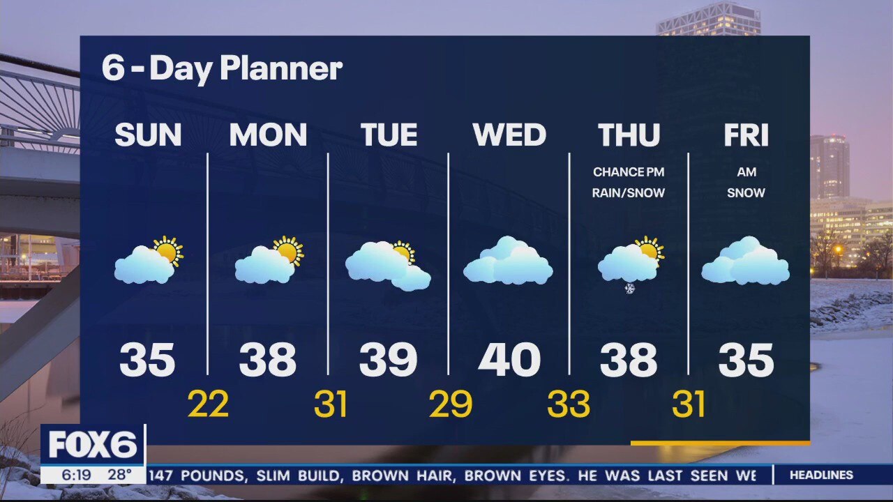
Sunshine will show today, but mostly cloudy skies to partly cloudy skies will remain in some areas south. Temperatures will be closer to average today in the lower 30s but will warm above average in the middle 30s by Sunday. Above average temps looks to be around much of next week in the upper 30s. Next chance of precipitation will be on Thursday late. Rain transitioning into snow is possible.
Sunshine will show today, but mostly cloudy skies to partly cloudy skies will remain in some areas south. Temperatures will be closer to average today in the lower 30s but will warm above average in the middle 30s by Sunday. Above average temps looks to be around much of next week in the upper 30s. Next chance of precipitation will be on Thursday late. Rain transitioning into snow is possible.
Weather Webcast with Meteorologist Eric Manges
FOX6 News at 6 offers the day's news, weather, and sports in southeast Wisconsin.
FOX6 News at 6 offers the day's news, weather, and sports in southeast Wisconsin.

Weather Webcast with Meteorologist Stephanie Barichello
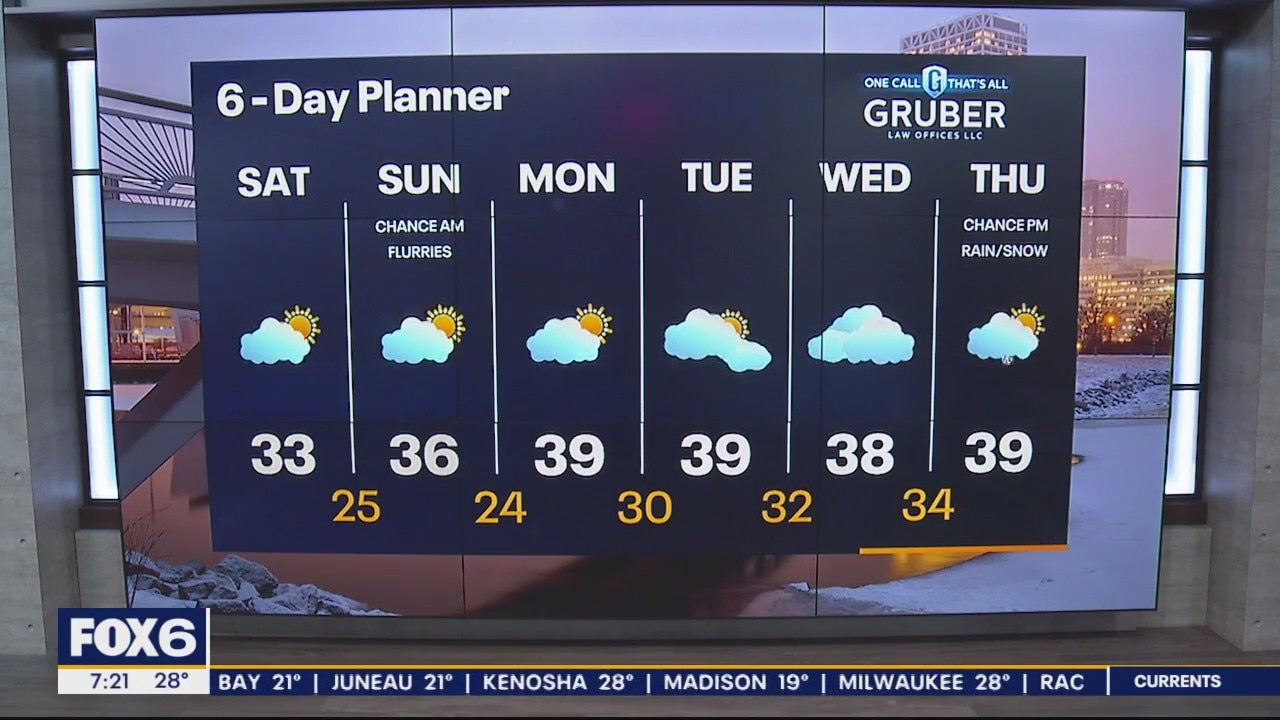
Another cloudy day but the sun will return...tomorrow! A cold start to Saturday otherwise a relatively mild weekend ahead. Only a slight chance for a few flurries early Sunday.
Another cloudy day but the sun will return...tomorrow! A cold start to Saturday otherwise a relatively mild weekend ahead. Only a slight chance for a few flurries early Sunday.

Weather webcast with Rob Haswell
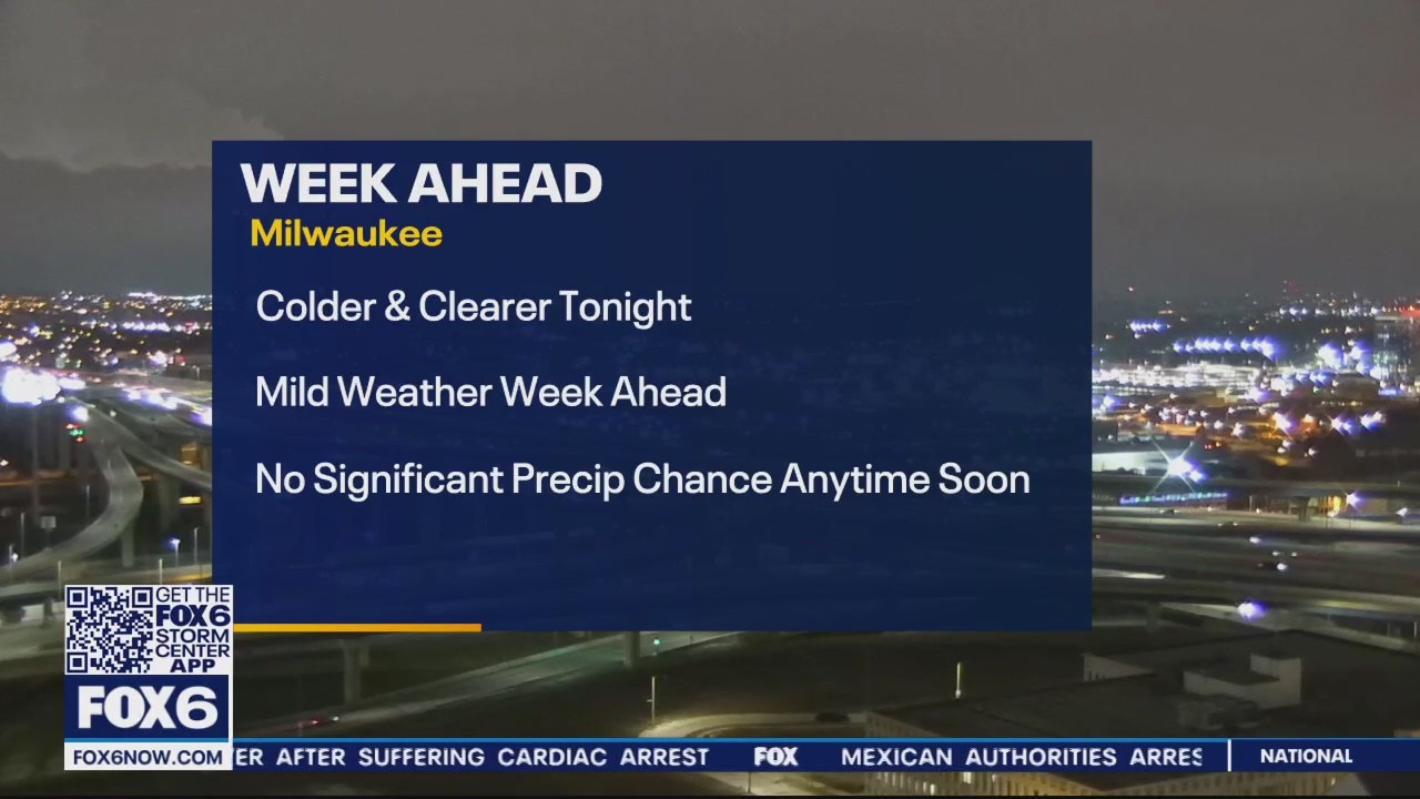
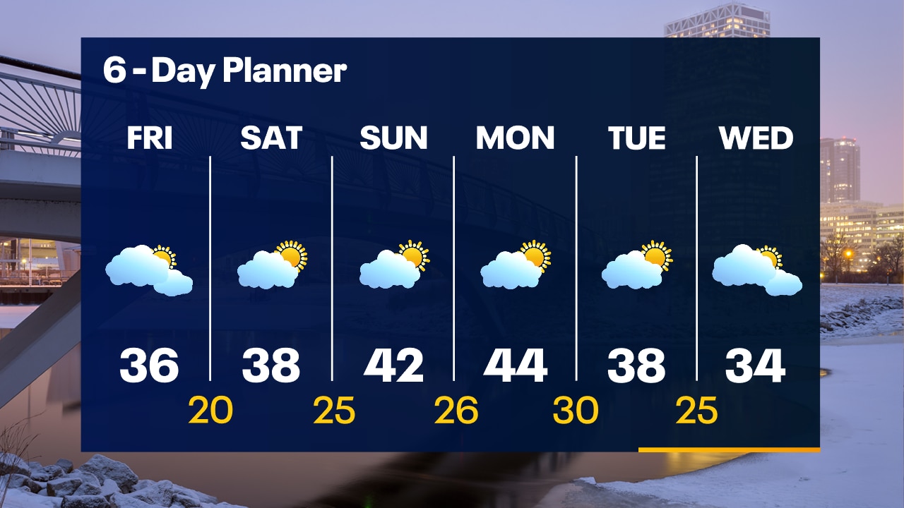
Our stubborn low finally makes its exit allowing high pressure to take over our forecast for several days ahead. We start cloudy and mild and should get some sunny breaks this afternoon with highs in the mid 30s likely. Partly cloudy again through the weekend with dry conditions. Highs will be in the upper 30s Saturday and low 40s Sunday. We stay in the 40s Monday and Tuesday with a slight cool down by Wednesday.
Our stubborn low finally makes its exit allowing high pressure to take over our forecast for several days ahead. We start cloudy and mild and should get some sunny breaks this afternoon with highs in the mid 30s likely. Partly cloudy again through the weekend with dry conditions. Highs will be in the upper 30s Saturday and low 40s Sunday. We stay in the 40s Monday and Tuesday with a slight cool down by Wednesday.
Weather Webcast with Tom Wachs
Flurries coming to an end overnight with temperatures falling into the 20s. Mostly cloudy on Friday with highs in the 30s. Peeks of the sun are possible late in the day Friday.
Flurries coming to an end overnight with temperatures falling into the 20s. Mostly cloudy on Friday with highs in the 30s. Peeks of the sun are possible late in the day Friday.