

Weather Webcast with Meteorologist Stephanie Barichello
Sunny and warm both today and tomorrow, then rain chances return Friday through the weekend.
Sunny and warm both today and tomorrow, then rain chances return Friday through the weekend.
Weather webcast with Rob Haswell
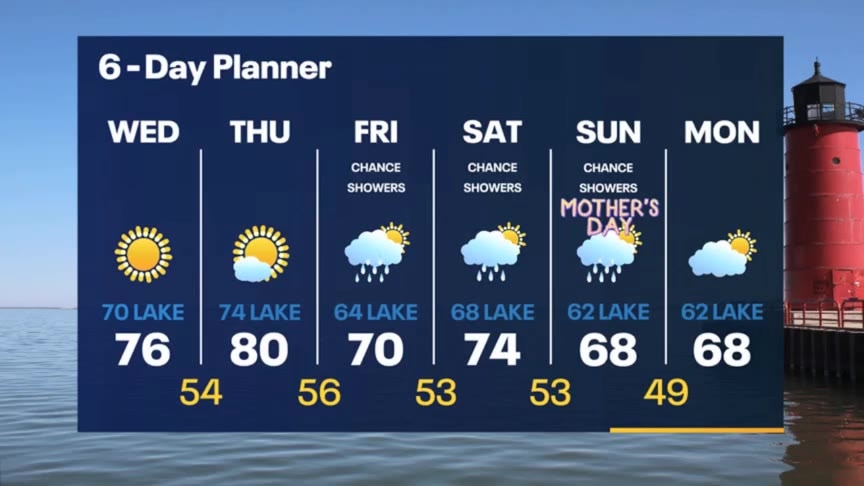
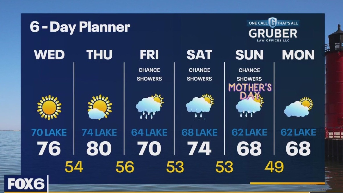
High pressure in place to give us another clear and calm day! High temperatures will reach the mid to upper 70s inland but stay near 70 lakeside with a steady southeast lake. Warming even further tomorrow with highs near 80 inland and low to mid 70s lakeside. Rain chances and cooler temperatures return on Friday and continue into the weekend including Mother's Day Sunday.
High pressure in place to give us another clear and calm day! High temperatures will reach the mid to upper 70s inland but stay near 70 lakeside with a steady southeast lake. Warming even further tomorrow with highs near 80 inland and low to mid 70s lakeside. Rain chances and cooler temperatures return on Friday and continue into the weekend including Mother's Day Sunday.

Weather Webcast with Tom Wachs
Partly cloudy and mild overnight. Temperatures in the mid-to-upper 40s by sunrise. Partly sunny and warm on Wednesday with highs in the middle 70s Wauwatosa and west, upper 60s near the lake.
Partly cloudy and mild overnight. Temperatures in the mid-to-upper 40s by sunrise. Partly sunny and warm on Wednesday with highs in the middle 70s Wauwatosa and west, upper 60s near the lake.

Weather Webcast with Tom Wachs
Partly cloudy and mild tonight. Temperatures dropping through the 50s and settling in the 40s overnight. Partly sunny and beautiful on Wednesday with highs in the mid-70s inland, upper 60s near the lake.
Partly cloudy and mild tonight. Temperatures dropping through the 50s and settling in the 40s overnight. Partly sunny and beautiful on Wednesday with highs in the mid-70s inland, upper 60s near the lake.
Weather Webcast with Meteorologist Stephanie Barichello
Plenty of sunshine today with temperatures in the 60s. We jump into the 70s Wednesday and Thursday, then rain chances return over the weekend.
Plenty of sunshine today with temperatures in the 60s. We jump into the 70s Wednesday and Thursday, then rain chances return over the weekend.

Weather webcast with Rob Haswell
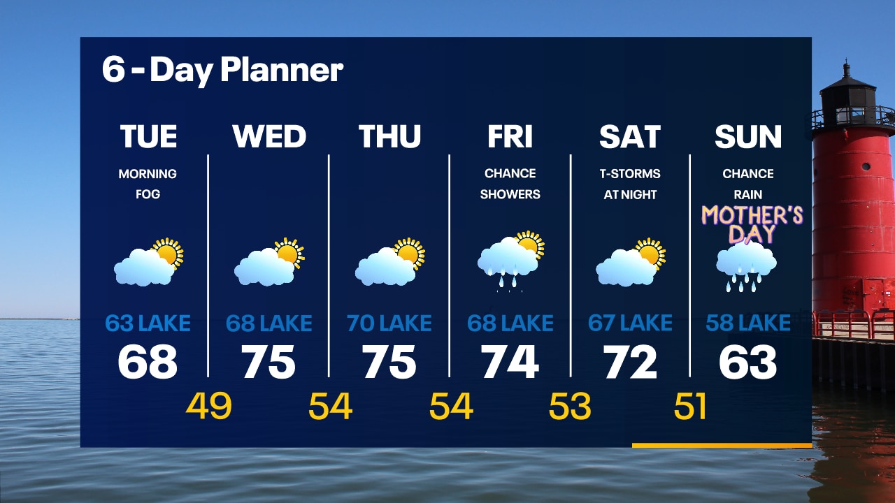
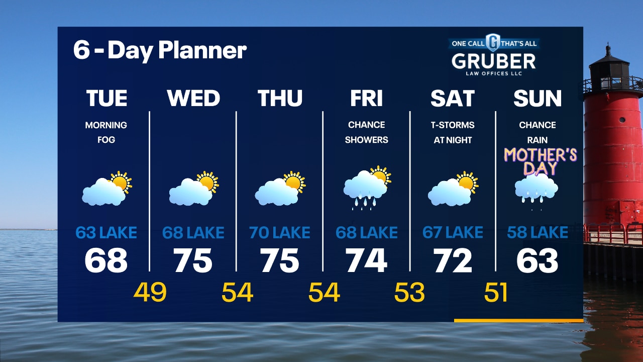
Dense Fog Advisory until 10am. Some areas may have less than 1/4 visibility. Drive with extra care. We clear to mostly sunny conditions this afternoon with highs near 70 inland and in the low 60s near the lake. We stay dry and mostly sunny Wednesday with slightly warming highs but again cooler near the lake. Rain chances return on Friday. Thunderstorms are possible Saturday night with a chilly rain on Sunday.
Dense Fog Advisory until 10am. Some areas may have less than 1/4 visibility. Drive with extra care. We clear to mostly sunny conditions this afternoon with highs near 70 inland and in the low 60s near the lake. We stay dry and mostly sunny Wednesday with slightly warming highs but again cooler near the lake. Rain chances return on Friday. Thunderstorms are possible Saturday night with a chilly rain on Sunday.
Weather Webcast with Tom Wachs
Areas of dense fog overnight with temperatures in the 40s. Morning fog followed by partly sunny skies on Tuesday. Warmer with highs in the 60s.
Areas of dense fog overnight with temperatures in the 40s. Morning fog followed by partly sunny skies on Tuesday. Warmer with highs in the 60s.
Weather Webcast with Tom Wachs
Rain tapering off tonight but the fog will stick around. Temperatures dropping into the 40s. Morning dense fog on Tuesday otherwise the sun returns with highs in the 60s.
Rain tapering off tonight but the fog will stick around. Temperatures dropping into the 40s. Morning dense fog on Tuesday otherwise the sun returns with highs in the 60s.

Weather Webcast with Meteorologist Stephanie Barichello
Rainy and cool today then sunny and back to 60s tomorrow. Quiet midweek, then a chance for rain returns Friday into the weekend.
Rainy and cool today then sunny and back to 60s tomorrow. Quiet midweek, then a chance for rain returns Friday into the weekend.
Weather webcast with Lisa Michaels
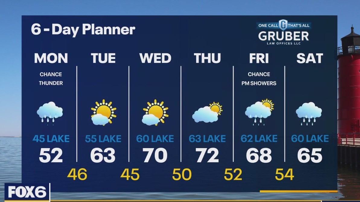
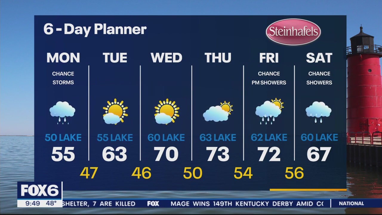
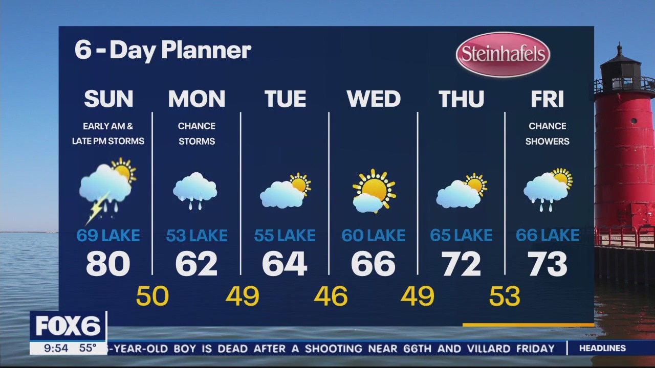
Rain increases through the day. Otherwise, cloudy and cool with highs ranging from the mid 40s near the lake to the mid 50s inland. Better weather arrives Tuesday with more sunshine and warming temps. Best day of the week will be Wednesday and Thursday with high temps in the low 70s. The next widespread chance of rain returns mainly Friday PM through Saturday.
Rain increases through the day. Otherwise, cloudy and cool with highs ranging from the mid 40s near the lake to the mid 50s inland. Better weather arrives Tuesday with more sunshine and warming temps. Best day of the week will be Wednesday and Thursday with high temps in the low 70s. The next widespread chance of rain returns mainly Friday PM through Saturday.
Weather Webcast with Meteorologist Eric Manges
From one of the nicest days of the year to a cruel lake breeze we stay cooler to start Monday
From one of the nicest days of the year to a cruel lake breeze we stay cooler to start Monday
Weather Webcast with Meteorologist Eric Manges
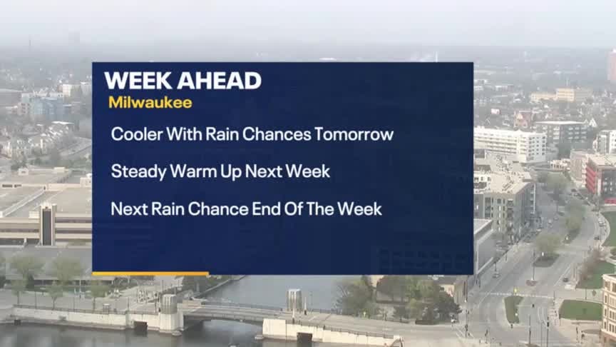
Much cooler with rain tomorrow but a steady warm-up this week.
Much cooler with rain tomorrow but a steady warm-up this week.
Weather Webcast with Meteorologist Lisa Michaels
Clouds will gradually clear today allowing sunshine to arrive. Highs in the upper 70s to low 80s. Storms re-enter the forecast tonight into early Monday. Scattered rain Monday with isolated rumbles of thunder. Coolest day of the week in the upper 50s.
Clouds will gradually clear today allowing sunshine to arrive. Highs in the upper 70s to low 80s. Storms re-enter the forecast tonight into early Monday. Scattered rain Monday with isolated rumbles of thunder. Coolest day of the week in the upper 50s.
Weather Webcast with Meteorologist Eric Manges
Storm chances early tomorrow morning and late tomorrow night into Monday
Storm chances early tomorrow morning and late tomorrow night into Monday

Weather Webcast with Meteorologist Eric Manges
Chance of storms both tonight and late Sunday night
Chance of storms both tonight and late Sunday night

Weather Webcast with Meteorologist Lisa Michaels
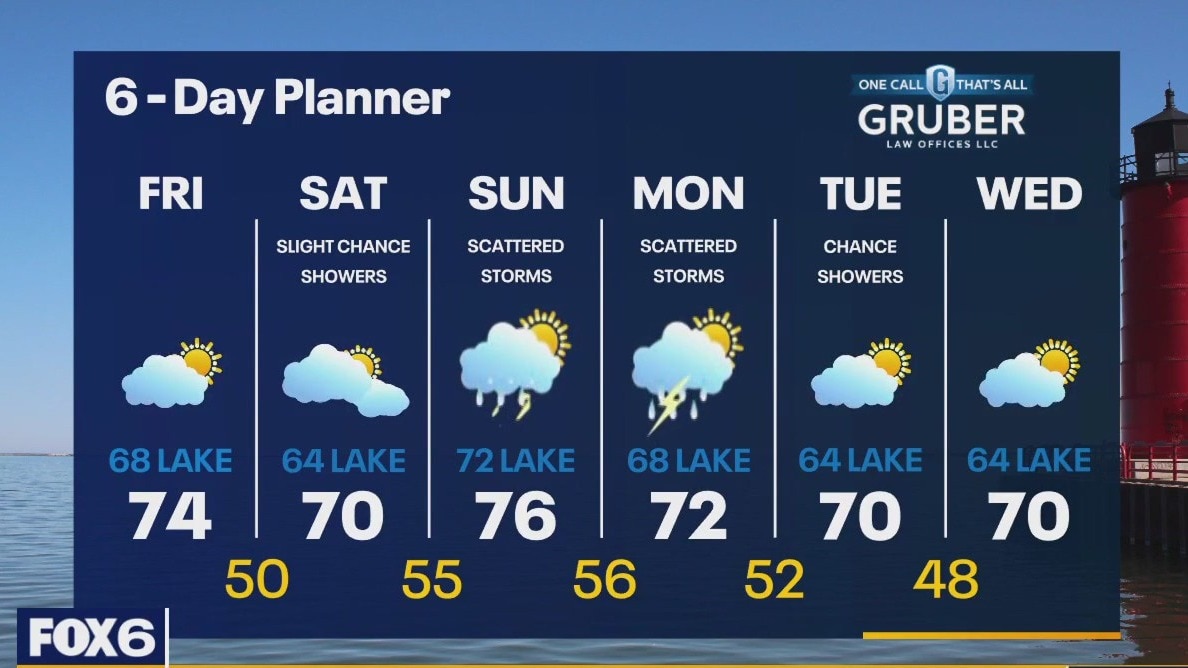
Light scattered rain and drizzle Saturday morning. Mild with temperatures starting in the 50s and warming into the upper 60s to low 70s inland. Another round of rain/storms arrives tonight into the predawn hours of Sunday. Isolated storms could be strong with hail.
Light scattered rain and drizzle Saturday morning. Mild with temperatures starting in the 50s and warming into the upper 60s to low 70s inland. Another round of rain/storms arrives tonight into the predawn hours of Sunday. Isolated storms could be strong with hail.

Weather Webcast with Meteorologist Eric Manges
Few rain chances Saturday but especially Sunday and Monday. Otherwise we're looking warm!
Few rain chances Saturday but especially Sunday and Monday. Otherwise we're looking warm!

Weather Webcast with Meteorologist Stephanie Barichello
A beautiful Friday afternoon ahead then some spotty rain chances over the weekend, but there will be plenty of dry time still. Temperatures will remain in the 60s and 70s.
A beautiful Friday afternoon ahead then some spotty rain chances over the weekend, but there will be plenty of dry time still. Temperatures will remain in the 60s and 70s.
Weather webcast with Rob Haswell
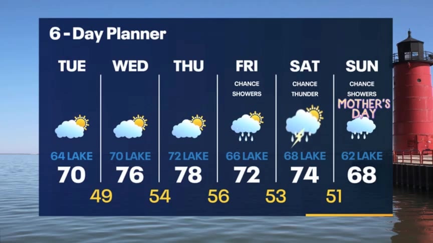
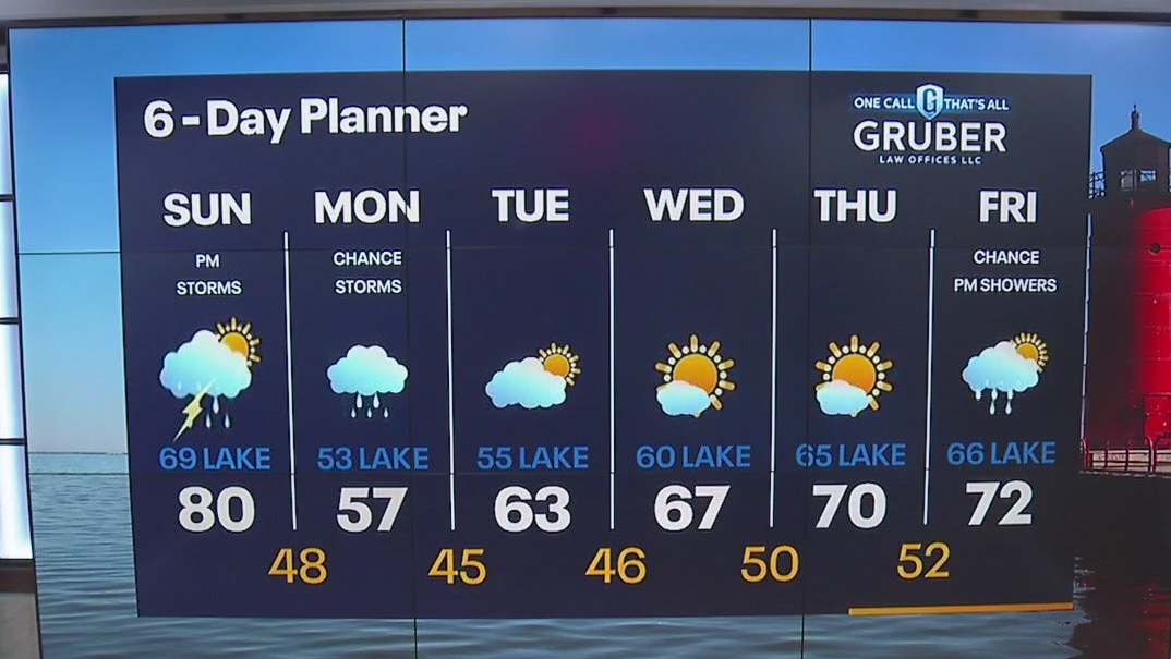
Partly sunny and warm today with highs in the low to mid 70s inland and upper 60s near Lake Michigan. A few chances for showers and thunderstorms this weekend with rain and thunderstorms likely by Sunday. We stay mild into next week with another chance for rain Monday and Tuesday. We should dry up on Wednesday and stay mild for the longer range.
Partly sunny and warm today with highs in the low to mid 70s inland and upper 60s near Lake Michigan. A few chances for showers and thunderstorms this weekend with rain and thunderstorms likely by Sunday. We stay mild into next week with another chance for rain Monday and Tuesday. We should dry up on Wednesday and stay mild for the longer range.

Weather Webcast with Meteorologist Eric Manges
Warmer weather is here to stay and it's about time
Warmer weather is here to stay and it's about time