

Weather Webcast with Tom Wachs
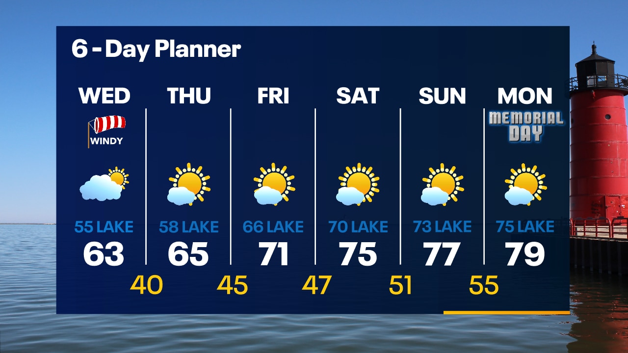
A cold front will move through overnight ushering in big changes on Wednesday. Windy and chilly with highs in the 50s near the lake and low 60s inland.
A cold front will move through overnight ushering in big changes on Wednesday. Windy and chilly with highs in the 50s near the lake and low 60s inland.
Weather Webcast with Tom Wachs
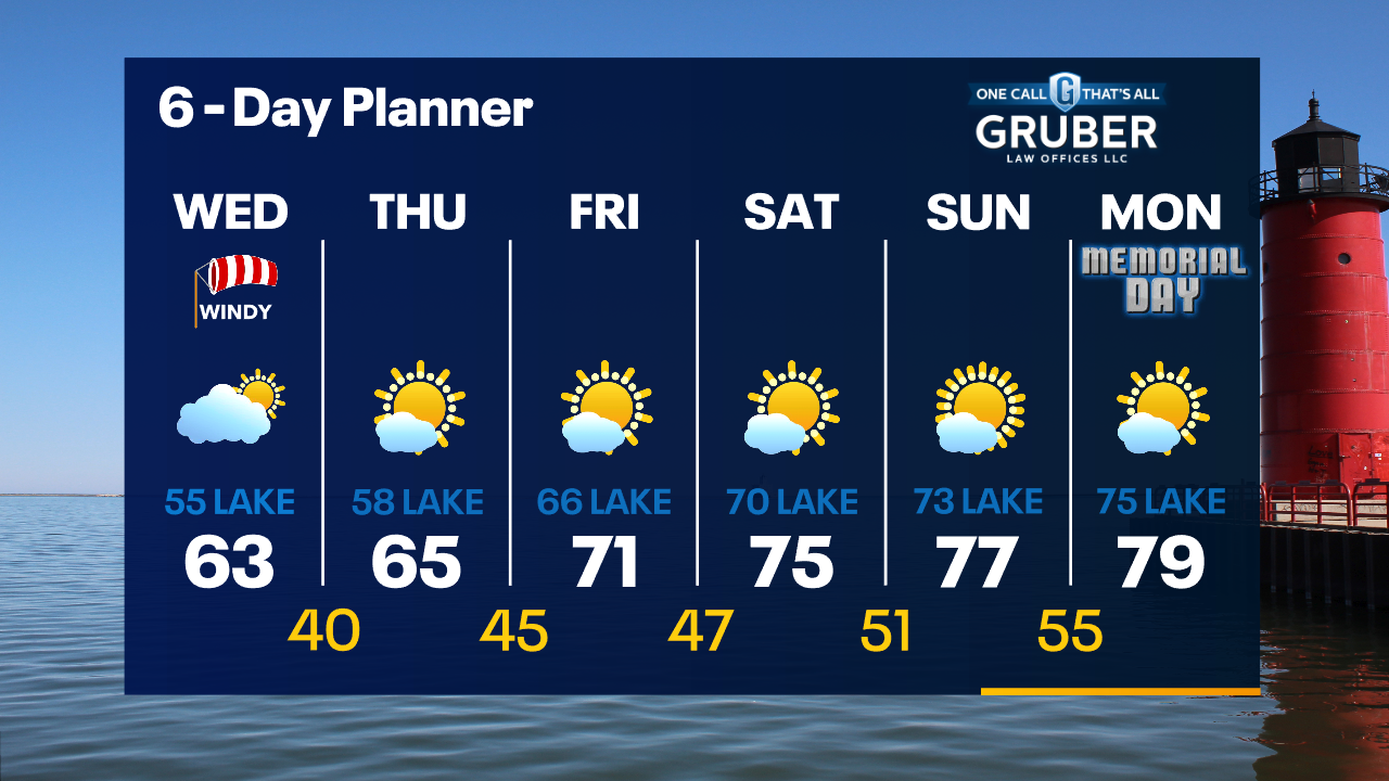
Clear and quiet tonight with temperatures dropping through the 60s and into the 50s overnight. Much cooler on Wednesday with highs in the 50s/60s with a strong NE wind.
Clear and quiet tonight with temperatures dropping through the 60s and into the 50s overnight. Much cooler on Wednesday with highs in the 50s/60s with a strong NE wind.
Weather Webcast with Meteorologist Eric Manges
Much cooler air tomorrow thanks to a "Back-Door" cold front
Much cooler air tomorrow thanks to a "Back-Door" cold front

Weather Webcast with Meteorologist Eric Manges
Staying summer like today but much cooler Wednesday and Thursday
Staying summer like today but much cooler Wednesday and Thursday
Weather webcast with Rob Haswell
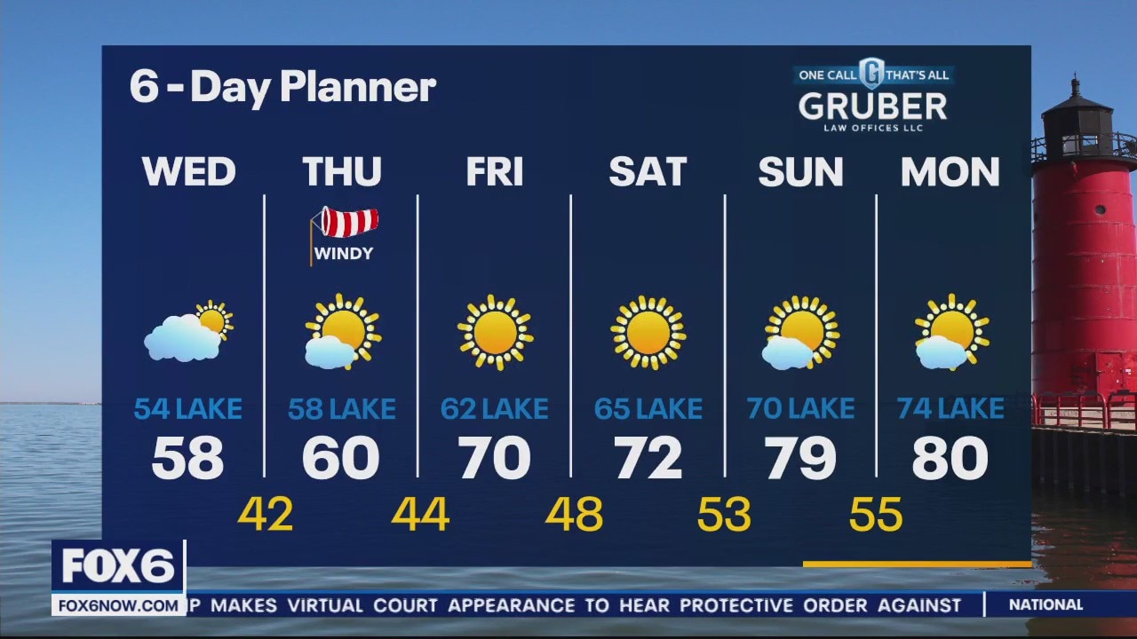
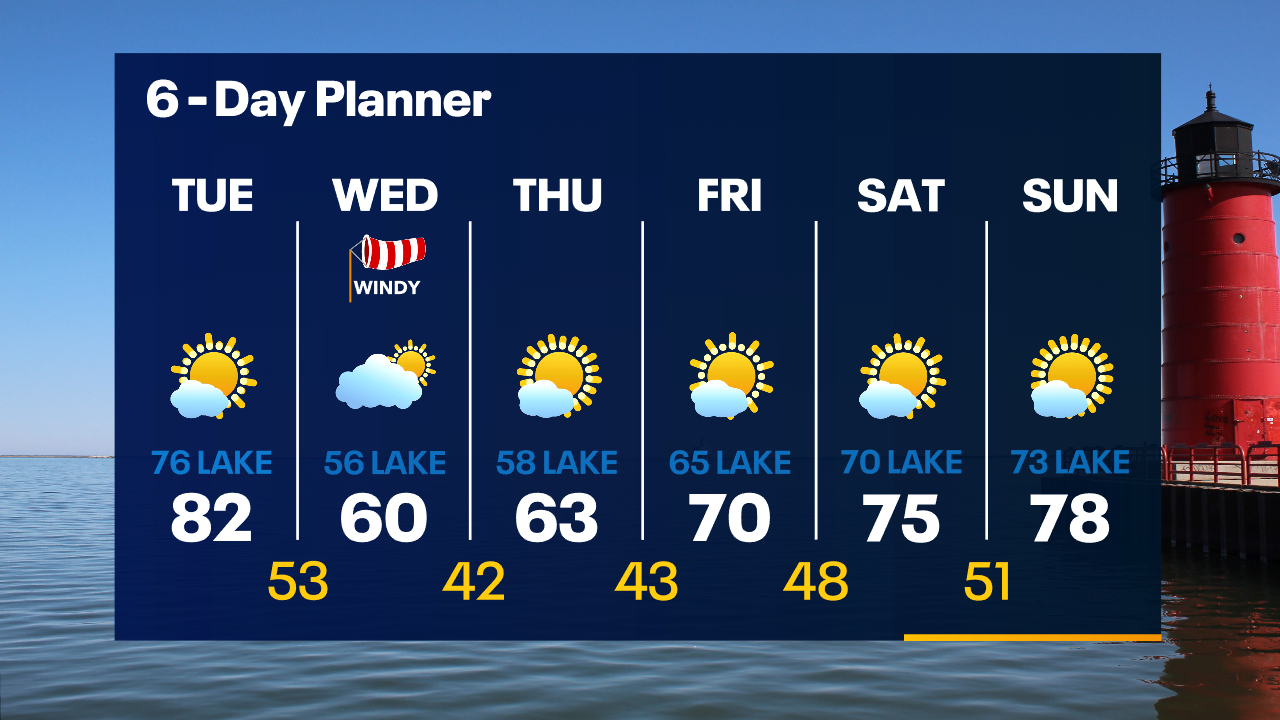
High pressure continues to be the big weather maker today keeping us sunny and mild with a strong south and southeast wind. Highs today will get to near 82 but stay in the 70s near the lake. A stronger lake breeze develops later in the afternoon to further drop temperatures. A strong "backdoor cold front" passes through on Wednesday dropping our highs into the 50s and low 60s and feeling much colder with a strong NE wind developing.
High pressure continues to be the big weather maker today keeping us sunny and mild with a strong south and southeast wind. Highs today will get to near 82 but stay in the 70s near the lake. A stronger lake breeze develops later in the afternoon to further drop temperatures. A strong "backdoor cold front" passes through on Wednesday dropping our highs into the 50s and low 60s and feeling much colder with a strong NE wind developing.

Weather Webcast with Tom Wachs
Clear skies overnight with temperatures dropping into the 50s. Mostly sunny and warmer on Tuesday with highs in the low 80s inland, mid-70s near the lake. Much cooler on Wednesday.
Clear skies overnight with temperatures dropping into the 50s. Mostly sunny and warmer on Tuesday with highs in the low 80s inland, mid-70s near the lake. Much cooler on Wednesday.
Weather Webcast with Tom Wachs
Clear skies tonight with temperatures falling through the 60s this evening and settling in the 50s overnight. Warm and sunny on Tuesday with highs in the 80s, 70s along the lake. Big cool down Wednesday.
Clear skies tonight with temperatures falling through the 60s this evening and settling in the 50s overnight. Warm and sunny on Tuesday with highs in the 80s, 70s along the lake. Big cool down Wednesday.

Weather webcast with Rob Haswell
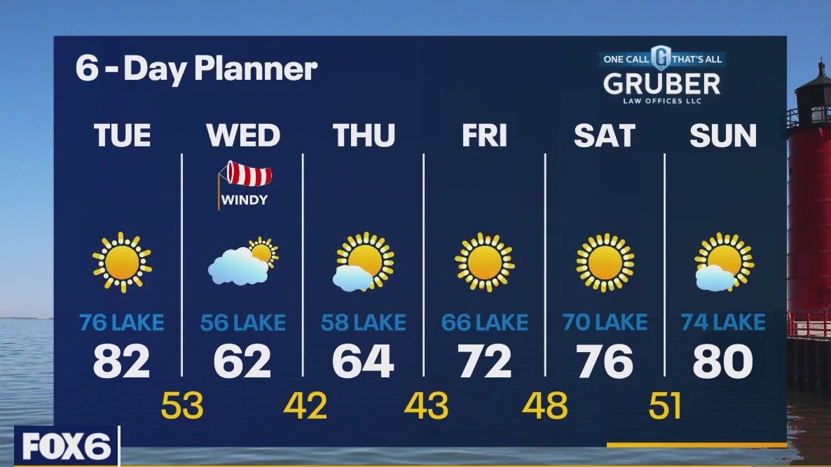
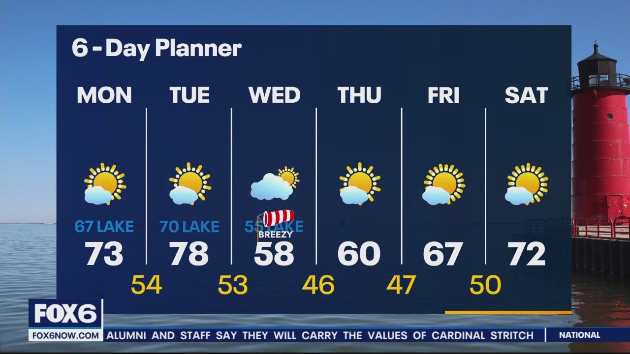
High pressure moving across the area for the next day or two will deliver sunshine and comfortable temperatures. Highs today will be near 80 inland but in the 70s lakeside. We will hit the 80s again Tuesday inland but again stay cooler near the lake. We cool down for a couple of days in the middle of the week before warming back up in time for our holiday weekend. We should stay dry all week.
High pressure moving across the area for the next day or two will deliver sunshine and comfortable temperatures. Highs today will be near 80 inland but in the 70s lakeside. We will hit the 80s again Tuesday inland but again stay cooler near the lake. We cool down for a couple of days in the middle of the week before warming back up in time for our holiday weekend. We should stay dry all week.
Weather Webcast with Meteorologist Eric Manges
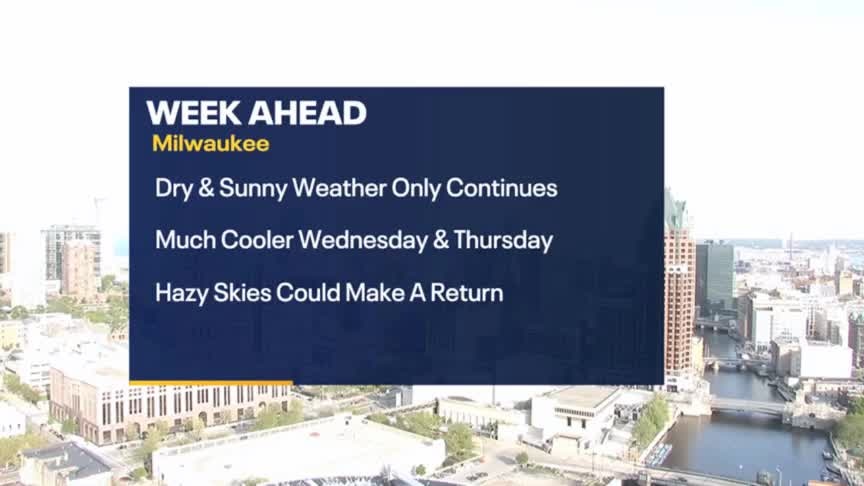
Sunshine and warm weather continues to start the week but a drop come Wednesday
Sunshine and warm weather continues to start the week but a drop come Wednesday
Weather Webcast with Meteorologist Eric Manges
Nice weather continues to start the week but a big cool down Wednesday and Thursday
Nice weather continues to start the week but a big cool down Wednesday and Thursday
Weather webcast with Lisa Michaels
A sunny and calm weather weekend ahead with air quality improving. Temperatures will stay in the 70s for the long term. Highs will be pushing 80F heading into Tuesday. A long dry stretch of weather is here to stay this upcoming week!
A sunny and calm weather weekend ahead with air quality improving. Temperatures will stay in the 70s for the long term. Highs will be pushing 80F heading into Tuesday. A long dry stretch of weather is here to stay this upcoming week!

Weather Webcast with Meteorologist Eric Manges
A long stretch of sunshine heading into the weekend and ya better get use to it
A long stretch of sunshine heading into the weekend and ya better get use to it
Weather webcast with Rob Haswell
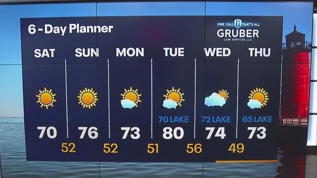
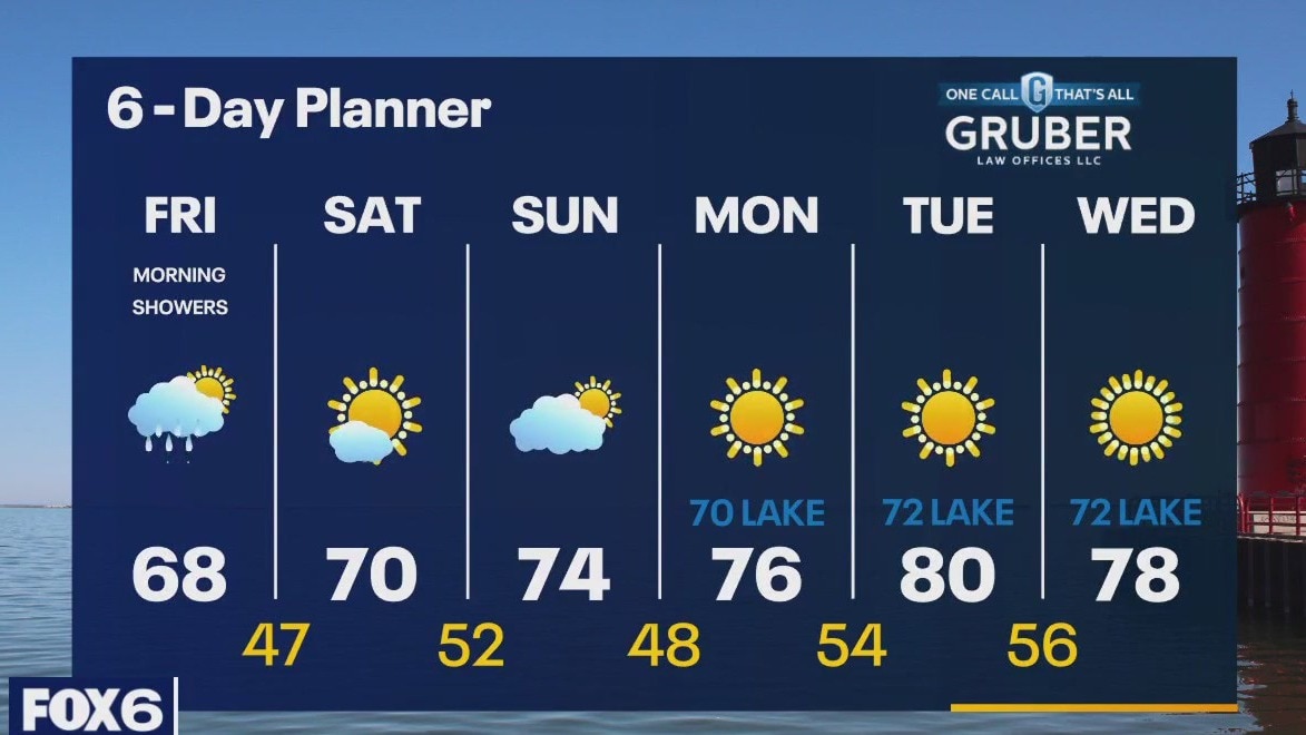
A cold front passing through brings us some rain this morning. Temperatures will recover to the upper 60s by the end of the day. An Air Quality Advisory has been issued for our area due to the wildfire smoke in the air today. A sunny stretch starts this weekend. Weekend temperatures will max out in the low 70s. We warm up next week with upper 70s and low 80s inland but cooler temperatures lakeside.
A cold front passing through brings us some rain this morning. Temperatures will recover to the upper 60s by the end of the day. An Air Quality Advisory has been issued for our area due to the wildfire smoke in the air today. A sunny stretch starts this weekend. Weekend temperatures will max out in the low 70s. We warm up next week with upper 70s and low 80s inland but cooler temperatures lakeside.

Weather Webcast with Meteorologist Eric Manges
Hazy skies continue into tomorrow with air quality concerns but some rain is possible Friday morning
Hazy skies continue into tomorrow with air quality concerns but some rain is possible Friday morning
Weather Webcast With Lisa Michaels
High pressure retreats to the east today allowing a cold front to move in from the west. Cold front will bring rain around midnight into the first half of Friday. Isolated rumbles of thunder possible. Amounts one tenth to quarter inch.
High pressure retreats to the east today allowing a cold front to move in from the west. Cold front will bring rain around midnight into the first half of Friday. Isolated rumbles of thunder possible. Amounts one tenth to quarter inch.

Weather webcast with Rob Haswell
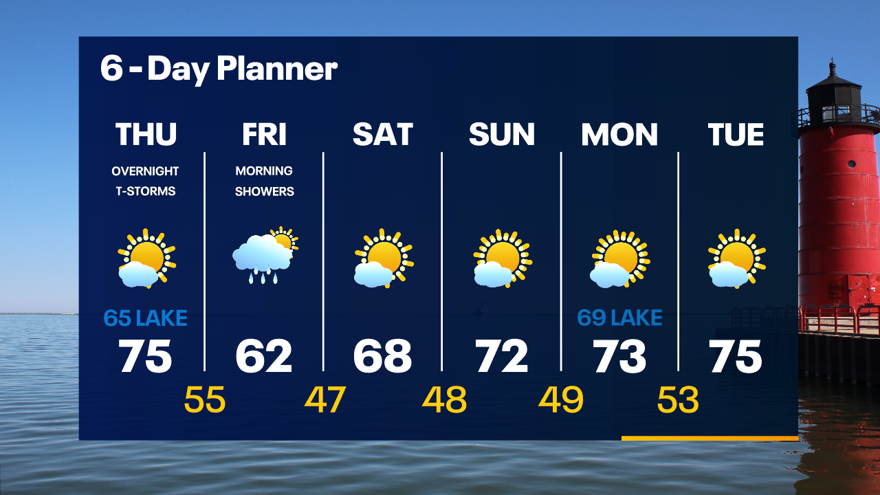
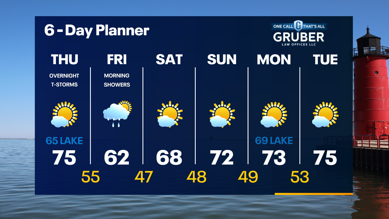
High pressure retreats to the east today allowing a cold front to move in from the west. Ahead of that front, we warm into the low 70s but remain in the 60s lakeside with a breeze over the lake. As the front moves through we can expect some showers with a slight chance of thunderstorms. We dry up by Friday afternoon and we stay dry with ample sun through the weekend.
High pressure retreats to the east today allowing a cold front to move in from the west. Ahead of that front, we warm into the low 70s but remain in the 60s lakeside with a breeze over the lake. As the front moves through we can expect some showers with a slight chance of thunderstorms. We dry up by Friday afternoon and we stay dry with ample sun through the weekend.
Weather Webcast with Tom Wachs
Mostly clear and chilly overnight with temperatures in the upper 30s to low 40s by sunrise. Mostly sunny with wildfire smoke in the sky Thursday. Highs in the mid-70s inland, mid-60s near the lake. T-Storms late Thursday night.
Mostly clear and chilly overnight with temperatures in the upper 30s to low 40s by sunrise. Mostly sunny with wildfire smoke in the sky Thursday. Highs in the mid-70s inland, mid-60s near the lake. T-Storms late Thursday night.
Weather Webcast with Tom Wachs
Mostly clear with wildfire smoke in the sky tonight. Temperatures dropping into the 40s. Mostly sunny with some wildfire smoke in the sky Thursday. Highs in the mid-70s inland, mid-60s near the lake. T-storms late Thursday night.
Mostly clear with wildfire smoke in the sky tonight. Temperatures dropping into the 40s. Mostly sunny with some wildfire smoke in the sky Thursday. Highs in the mid-70s inland, mid-60s near the lake. T-storms late Thursday night.
Weather Webcast with Meteorologist Eric Manges
Rain to end the week but finally a sunny and warm weekend
Rain to end the week but finally a sunny and warm weekend
Weather webcast with Rob Haswell
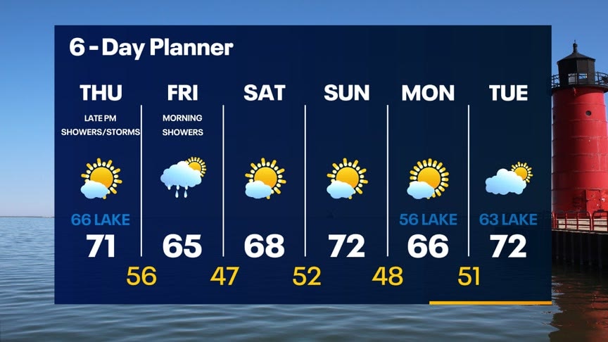
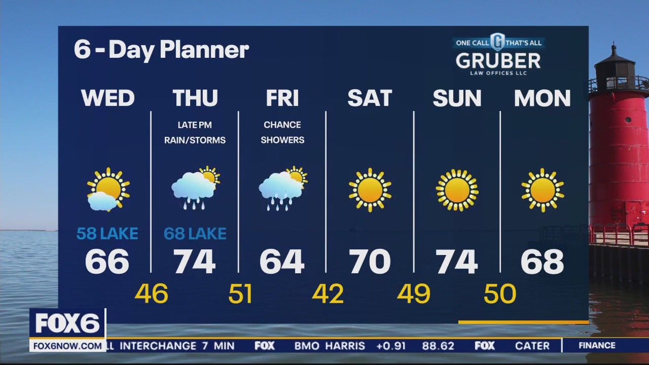
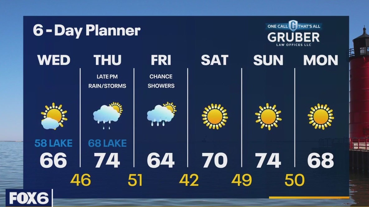
High pressure builds in from the north today to keep us dry and bring some sun. We start our a bit chilly but warm to the upper 60s inland and upper 50s lakeside this afternoon. Ahead of an approaching low on Thursday we warm into the mid 70s with upper 60s lakeside. Rain arrives late Thursday evening with a slight chance for thunderstorms overnight. Rain tapers off through the day on Friday with a dry and sunny weekend in store.
High pressure builds in from the north today to keep us dry and bring some sun. We start our a bit chilly but warm to the upper 60s inland and upper 50s lakeside this afternoon. Ahead of an approaching low on Thursday we warm into the mid 70s with upper 60s lakeside. Rain arrives late Thursday evening with a slight chance for thunderstorms overnight. Rain tapers off through the day on Friday with a dry and sunny weekend in store.