

Weather webcast with Rob Haswell
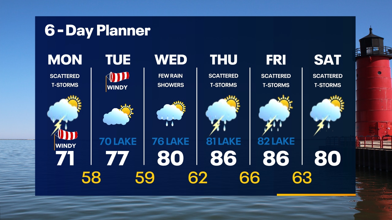
Air Quality Alert for all of SE WI until Noon Thursday. Wildfire smoke remains in the unhealthy range today but should improve later today and tomorrow. Scattered showers and thunderstorms this morning with another round possible later today and tonight. There is a possibility of strong to severe storms. Highs today will be in the mid to upper 80s and dewpoints will rise to the upper 60s for a very sticky day.
Air Quality Alert for all of SE WI until Noon Thursday. Wildfire smoke remains in the unhealthy range today but should improve later today and tomorrow. Scattered showers and thunderstorms this morning with another round possible later today and tonight. There is a possibility of strong to severe storms. Highs today will be in the mid to upper 80s and dewpoints will rise to the upper 60s for a very sticky day.

Weather Webcast with Tom Wachs
T-Storms are possible overnight with smoky skies and temperatures in the 60s. Warm and humid on Thursday with highs in the mid-80s. Scattered afternoon/evening t-storms possible.
T-Storms are possible overnight with smoky skies and temperatures in the 60s. Warm and humid on Thursday with highs in the mid-80s. Scattered afternoon/evening t-storms possible.
Weather Webcast with Tom Wachs
Wildfire smoke will get worse this evening with temperatures falling into the 60s. A line of t-storms could move into SE WI after 3am.
Wildfire smoke will get worse this evening with temperatures falling into the 60s. A line of t-storms could move into SE WI after 3am.
Weather Webcast with Meteorologist Eric Manges
Wildfire smoke still a concern until Thursday afternoon then storm chances return
Wildfire smoke still a concern until Thursday afternoon then storm chances return

Weather webcast with Rob Haswell
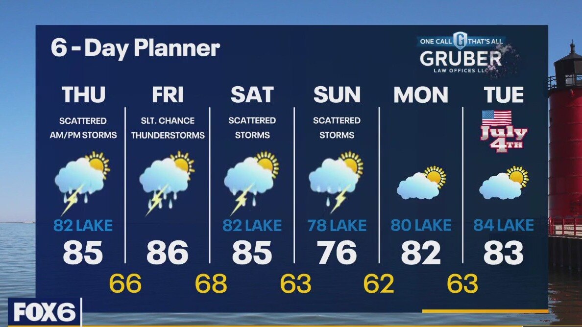
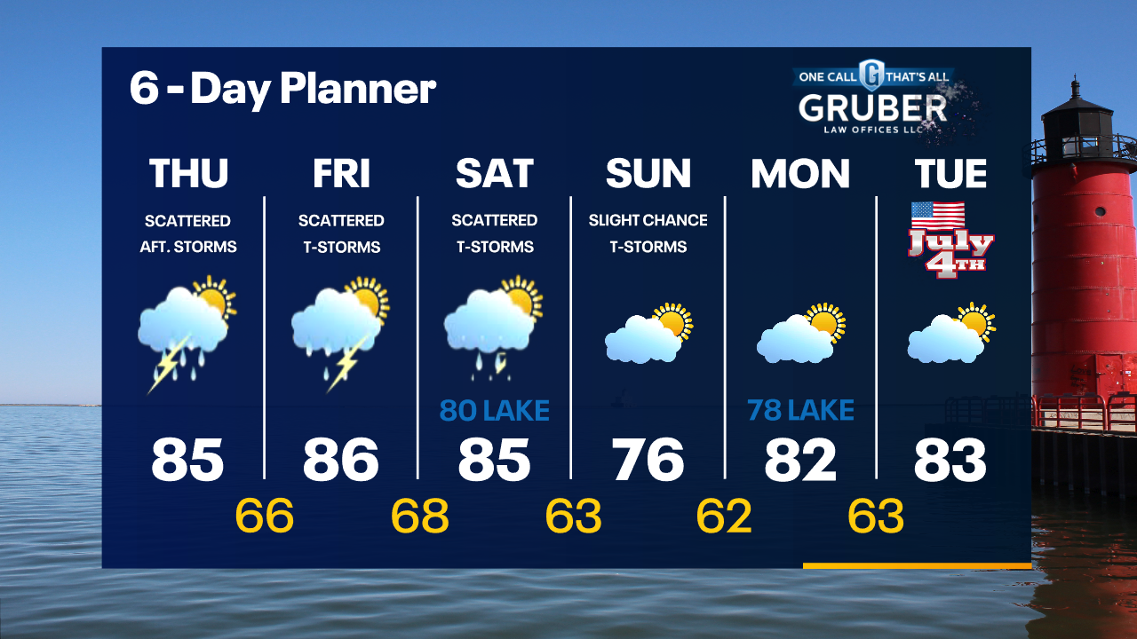
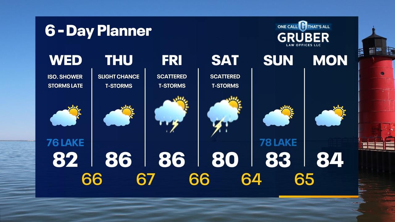
Air Quality Alert for all of SE WI until Noon Thursday. Another smoky day with highs in the low 80s inland and mid to upper 70s lakeside. There is a slight chance for a few showers today. Rain and thunderstorms are possible overnight and through parts of the day on Thursday. There is a Marginal to Slight risk of severe storms during this time. We continue with a chance for showers and thunderstorms from Friday through the weekend. None of those days will be complete wash outs.
Air Quality Alert for all of SE WI until Noon Thursday. Another smoky day with highs in the low 80s inland and mid to upper 70s lakeside. There is a slight chance for a few showers today. Rain and thunderstorms are possible overnight and through parts of the day on Thursday. There is a Marginal to Slight risk of severe storms during this time. We continue with a chance for showers and thunderstorms from Friday through the weekend. None of those days will be complete wash outs.
Weather Webcast with Tom Wachs
Smoky skies continue for the next few days but conditions will gradually improve. Highs in the 70s lakeside, 80s inland on Wednesday with an isolated rain shower. T-Storms are possible late Wednesday night.
Smoky skies continue for the next few days but conditions will gradually improve. Highs in the 70s lakeside, 80s inland on Wednesday with an isolated rain shower. T-Storms are possible late Wednesday night.
Weather Webcast with Tom Wachs
Wildfire smoke continues tonight. It will get a little better Wednesday and a little better again on Thursday. T-Storm chances return late Wednesday night.
Wildfire smoke continues tonight. It will get a little better Wednesday and a little better again on Thursday. T-Storm chances return late Wednesday night.

Weather Webcast with Meteorologist Eric Manges
Wildfire smoke concerns through Thursday afternoon
Wildfire smoke concerns through Thursday afternoon
Weather webcast with Rob Haswell
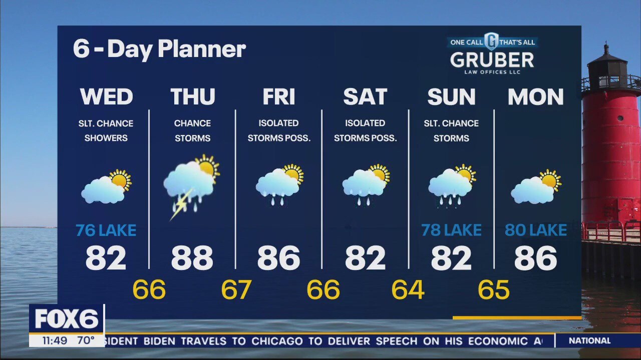
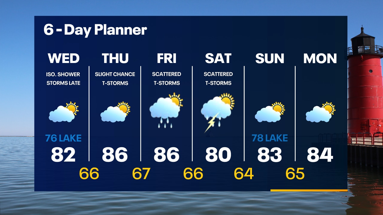
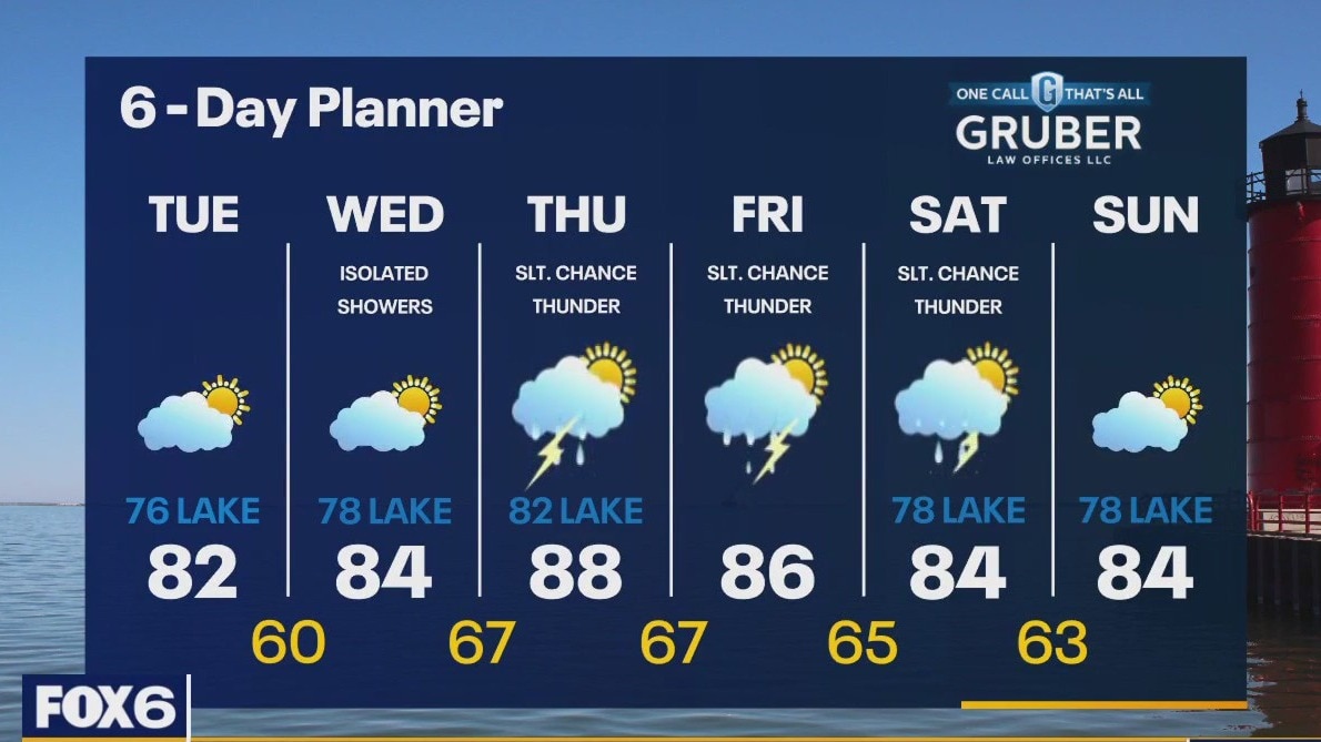
Air Quality Alert for all of SE WI until Noon Thursday Another smoky day today with reduced visibility in some areas as a result. A dry day today with high pressure moving over the region. We warm into the low 80s inland but stay in the mid to upper 70s lakeside with a breeze off of Lake Michigan this afternoon. Chances for showers continue with slight chances for thunderstorms through Thursday and into the weekend. However, none of those days will be all day wash outs.
Air Quality Alert for all of SE WI until Noon Thursday Another smoky day today with reduced visibility in some areas as a result. A dry day today with high pressure moving over the region. We warm into the low 80s inland but stay in the mid to upper 70s lakeside with a breeze off of Lake Michigan this afternoon. Chances for showers continue with slight chances for thunderstorms through Thursday and into the weekend. However, none of those days will be all day wash outs.
Weather Webcast with Tom Wachs
Smoky skies are forecast to continue for the next several days. Mostly sunny, but smoky on Tuesday. Highs in the 80s inland, 70s near the lake.
Smoky skies are forecast to continue for the next several days. Mostly sunny, but smoky on Tuesday. Highs in the 80s inland, 70s near the lake.

Weather Webcast with Tom Wachs
Rain ending this evening but wildfire smoke will continue into Thursday. Mostly sunny and warmer on Tuesday with highs in the 80s inland, 70s near the lake.
Rain ending this evening but wildfire smoke will continue into Thursday. Mostly sunny and warmer on Tuesday with highs in the 80s inland, 70s near the lake.

Weather webcast with Rob Haswell
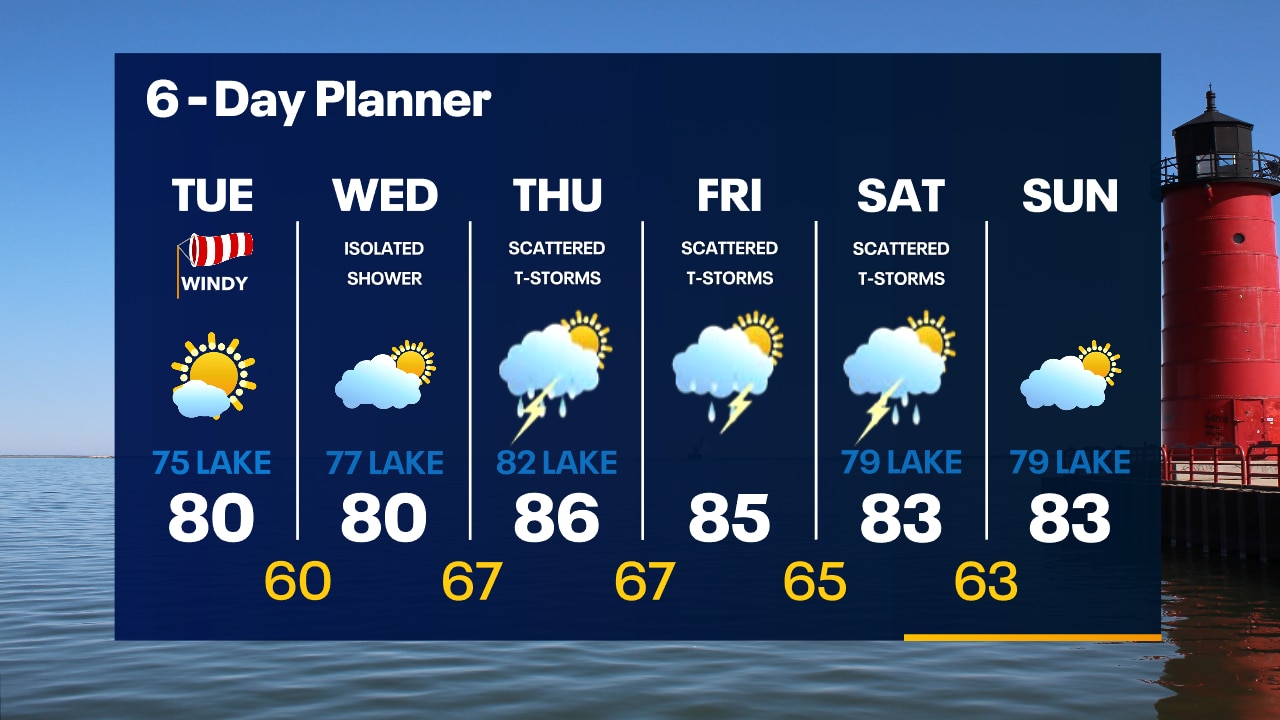
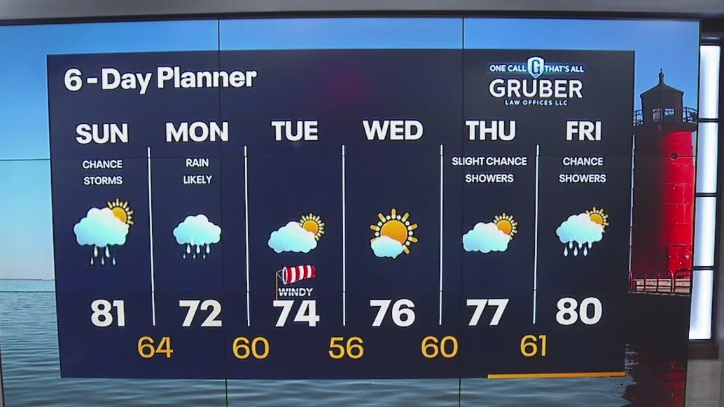
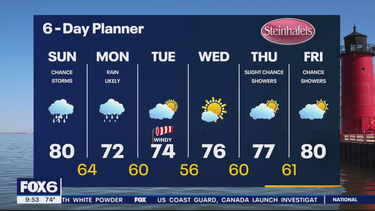
A low to our east will continue to provide a few showers and a chance for isolated thunderstorms today. Highs will be in the low to mid 70s today and feel cooler with a strong NW wind. We should dry up and warm up Tuesday with highs in the upper 78s with cooler conditions lakeside. We warm back to the 80s later this week with a chance for showers and thunderstorms returning though no total wash-outs.
A low to our east will continue to provide a few showers and a chance for isolated thunderstorms today. Highs will be in the low to mid 70s today and feel cooler with a strong NW wind. We should dry up and warm up Tuesday with highs in the upper 78s with cooler conditions lakeside. We warm back to the 80s later this week with a chance for showers and thunderstorms returning though no total wash-outs.
Weather Webcast with Tom Wachs
Rain showers tapering off overnight with temperatures in the 60s. Scattered rain showers and t-storms on Monday with a windy high in the low 70s.
Rain showers tapering off overnight with temperatures in the 60s. Scattered rain showers and t-storms on Monday with a windy high in the low 70s.
Weather Webcast with Tom Wachs
Scattered showers and t-storms will taper off overnight only to redevelop again on Monday. Temperatures in the 60s overnight. Windy and cooler Monday with off-and-on storms and highs in the low 70s.
Scattered showers and t-storms will taper off overnight only to redevelop again on Monday. Temperatures in the 60s overnight. Windy and cooler Monday with off-and-on storms and highs in the low 70s.
Weather Webcast with Meteorologist Lisa Michaels
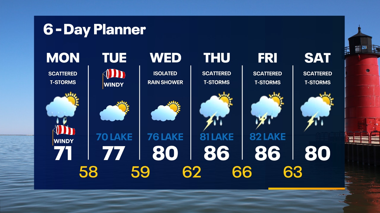
Scattered storms move in tonight and continue through early Sunday morning. Rain and storm potential continues on and off through Sunday. Mostly just rain Monday with cooler air rushing in behind this system.
Scattered storms move in tonight and continue through early Sunday morning. Rain and storm potential continues on and off through Sunday. Mostly just rain Monday with cooler air rushing in behind this system.
Weather Webcast with Meteorologist Eric Manges
Storms Sunday possible and rain mostly Monday followed by cooler temps next week
Storms Sunday possible and rain mostly Monday followed by cooler temps next week
Weather Webcast with Meteorologist Eric Manges
Storm chances tonight and Sunday with rain potential lasting into Monday night
Storm chances tonight and Sunday with rain potential lasting into Monday night
Weather Webcast with Meteorologist Lisa Michaels
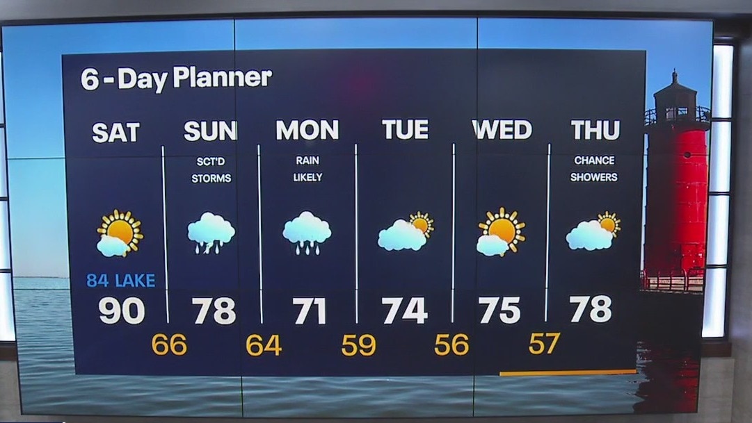
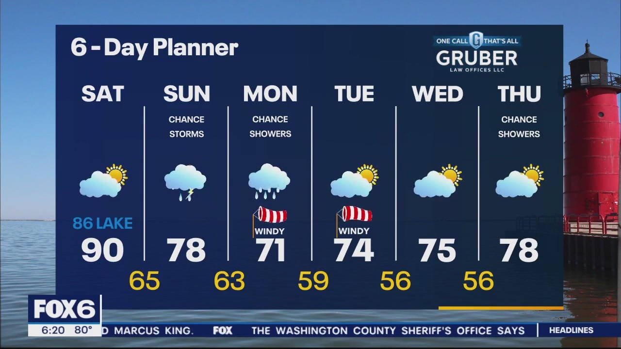
Air Quality Alert for All of SE WI until 11pm Today The warmest day of the week is Saturday with high temps in the upper 80s to low 90s. Storm potential returns Sunday and transitions to mostly rain on Monday.
Air Quality Alert for All of SE WI until 11pm Today The warmest day of the week is Saturday with high temps in the upper 80s to low 90s. Storm potential returns Sunday and transitions to mostly rain on Monday.

Weather Webcast with Meteorologist Eric Manges
Hot weather Saturday then storms Sunday and dreary rain on Monday
Hot weather Saturday then storms Sunday and dreary rain on Monday
Weather Webcast with Meteorologist Eric Manges
Storms finally back in the forecast Sunday and rain chances lasting into Monday
Storms finally back in the forecast Sunday and rain chances lasting into Monday