

Weather Webcast with Lisa Michaels
Mostly clear tonight with temps dripping into the low to mid 40s by Thursday morning. Areas of moderate to dense fog are possible during the start of Thursday. Mostly sunny skies Thursday with highs in the upper 60s to 70 degrees. Warmer temperatures return by Friday in the upper 70s. Next chance of rain arrives by Saturday. Tonight: Mostly Clear
Mostly clear tonight with temps dripping into the low to mid 40s by Thursday morning. Areas of moderate to dense fog are possible during the start of Thursday. Mostly sunny skies Thursday with highs in the upper 60s to 70 degrees. Warmer temperatures return by Friday in the upper 70s. Next chance of rain arrives by Saturday. Tonight: Mostly Clear
Weather Webcast with Stephanie Barichello
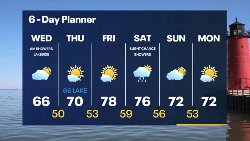
After an eventful morning of waterspout sightings, we enjoy sunshine the rest of the afternoon. Temperatures will be cool in the 60s. Even colder tomorrow morning with lows in the 40s, possibly even 30s, then we jump into the upper 70s by Friday.
After an eventful morning of waterspout sightings, we enjoy sunshine the rest of the afternoon. Temperatures will be cool in the 60s. Even colder tomorrow morning with lows in the 40s, possibly even 30s, then we jump into the upper 70s by Friday.
Weather webcast with Rob Haswell
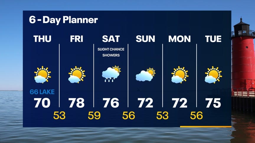
Some fog this morning with a Dense Fog Advisory in effect for Waukesha, Walworth and Jefferson counties. A few early sprinkles are also possible before high pressure helps to clear things out. Highs today will stay in the 60s but should warm to near 70 tomorrow and well into the 70s Friday and Saturday. Our next chance for showers comes on Saturday but we dry up again Sunday and Monday.
Some fog this morning with a Dense Fog Advisory in effect for Waukesha, Walworth and Jefferson counties. A few early sprinkles are also possible before high pressure helps to clear things out. Highs today will stay in the 60s but should warm to near 70 tomorrow and well into the 70s Friday and Saturday. Our next chance for showers comes on Saturday but we dry up again Sunday and Monday.

Weather Webcast With Lisa Michaels
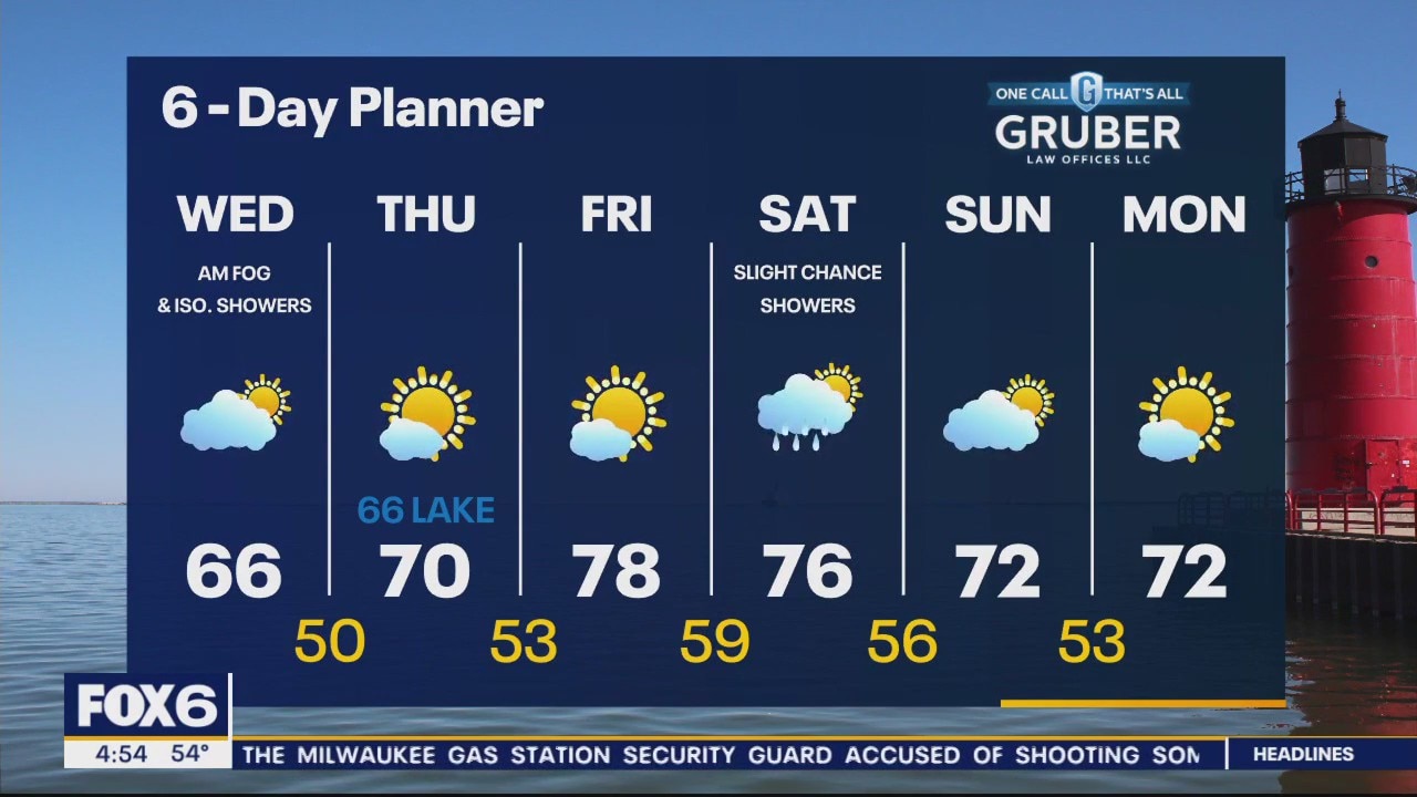
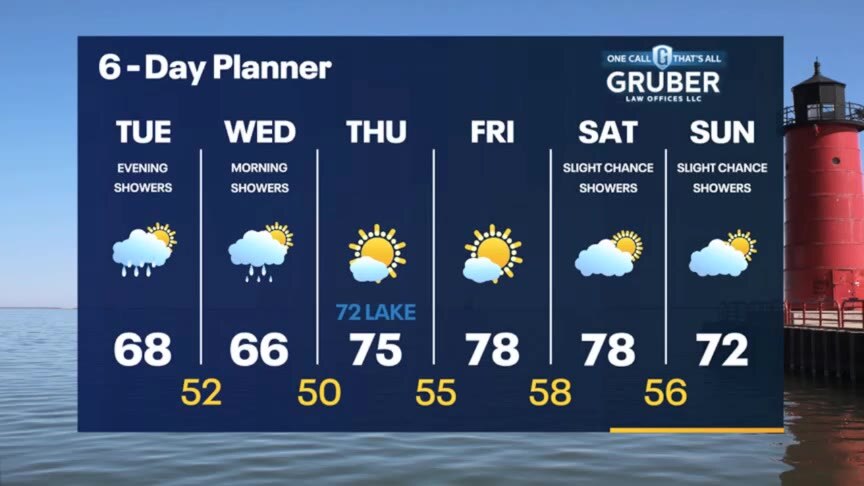
A relatively weak system moves through overnight with a chance for a few showers/storms tonight into early tomorrow morning. Clouds/showers linger into early Wednesday. Temps will begin the day in the low to mid 50s. High temps stay in the 60s through Wednesday, but warm back to the mid to upper 70s Thursday and Friday. We should be in the mid 70s to start the weekend with low 70s by Sunday and only a slight chance of showers.
A relatively weak system moves through overnight with a chance for a few showers/storms tonight into early tomorrow morning. Clouds/showers linger into early Wednesday. Temps will begin the day in the low to mid 50s. High temps stay in the 60s through Wednesday, but warm back to the mid to upper 70s Thursday and Friday. We should be in the mid 70s to start the weekend with low 70s by Sunday and only a slight chance of showers.
Weather webcast with Rob Haswell
We are in between areas of low pressure for much of the daylight hours today with partly cloudy conditions and highs in the upper 60s. A relatively weak low moves through overnight with a chance for a few showers tonight into early tomorrow morning. Highs dip a little Wednesday but warm back to the mid to upper 70s Thursday and Friday. We should be in the mid 70s to start the weekend with low 70s by Sunday and only a slight chance of showers.
We are in between areas of low pressure for much of the daylight hours today with partly cloudy conditions and highs in the upper 60s. A relatively weak low moves through overnight with a chance for a few showers tonight into early tomorrow morning. Highs dip a little Wednesday but warm back to the mid to upper 70s Thursday and Friday. We should be in the mid 70s to start the weekend with low 70s by Sunday and only a slight chance of showers.
Weather Webcast with Stephanie Barichello
Rain ends this evening, then another round is possible Tuesday evening into Wednesday morning. Quiet then the rest of the week.
Rain ends this evening, then another round is possible Tuesday evening into Wednesday morning. Quiet then the rest of the week.
Weather Webcast With Lisa Michaels
Isolated rain/drizzle this afternoon. Highs in the low to mid 60s. A few more showers will be possible Tuesday late afternoon through early Wednesday. Some sun Tuesday afternoon, but more is in store later this week. Temperatures stay in the 60s through midweek then gradually rise in the 70s by the weekend.
Isolated rain/drizzle this afternoon. Highs in the low to mid 60s. A few more showers will be possible Tuesday late afternoon through early Wednesday. Some sun Tuesday afternoon, but more is in store later this week. Temperatures stay in the 60s through midweek then gradually rise in the 70s by the weekend.

Weather webcast with Lisa Michaels
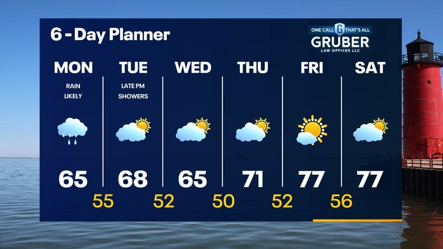
Steady rain through Monday. It will taper off this afternoon/evening. Amounts can range from 0.2" to over 0.5". Highs in the low to mid 60s on Monday under cloudy skies. A few more showers will be possible Tuesday afternoon then sunshine returns Wednesday. Temperatures stay in the 60s through midweek then gradually rise in the 70s by the weekend.
Steady rain through Monday. It will taper off this afternoon/evening. Amounts can range from 0.2" to over 0.5". Highs in the low to mid 60s on Monday under cloudy skies. A few more showers will be possible Tuesday afternoon then sunshine returns Wednesday. Temperatures stay in the 60s through midweek then gradually rise in the 70s by the weekend.

Weather Webcast with Stephanie Barichello
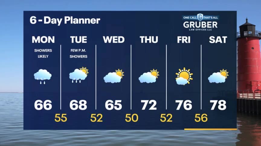
Rain showers arrive early Monday morning and continue at times through the evening. It'll also be a cool day in the 60s. A few more showers Tuesday night then a quiet forecast though the weekend.
Rain showers arrive early Monday morning and continue at times through the evening. It'll also be a cool day in the 60s. A few more showers Tuesday night then a quiet forecast though the weekend.
Weather Webcast with Stephanie Barichello
After a beautiful weekend, a steady rain returns Monday. It'll be a dreary and cool day in the 60s. Only a slight chance for showers late in the day Tuesday then sunshine takes over the rest of the week.
After a beautiful weekend, a steady rain returns Monday. It'll be a dreary and cool day in the 60s. Only a slight chance for showers late in the day Tuesday then sunshine takes over the rest of the week.

Weather Webcast With Rob Haswell
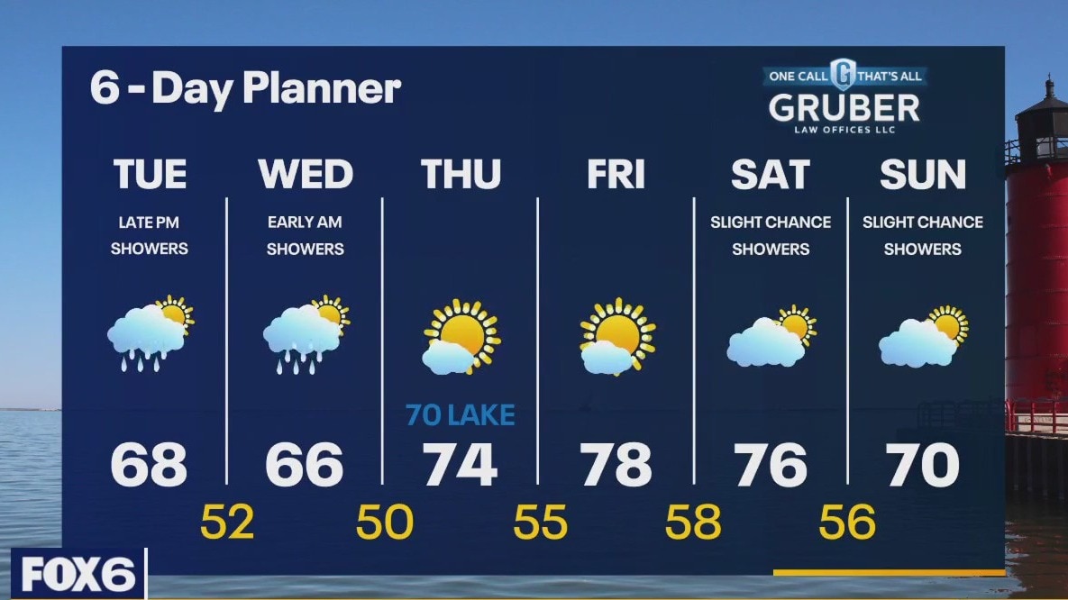
A low passing over our area today will help to generate a few showers this morning with a steadier rain developing tonight and into Monday. Highs today hit the low to mid 70s but fall to the 60s Monday and Tuesday on the backside of this passing system. We should dry up on Wednesday and stay cooler but a warm up returns later next week.
A low passing over our area today will help to generate a few showers this morning with a steadier rain developing tonight and into Monday. Highs today hit the low to mid 70s but fall to the 60s Monday and Tuesday on the backside of this passing system. We should dry up on Wednesday and stay cooler but a warm up returns later next week.
Weather Webcast With Lisa Michaels
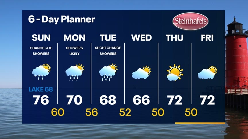
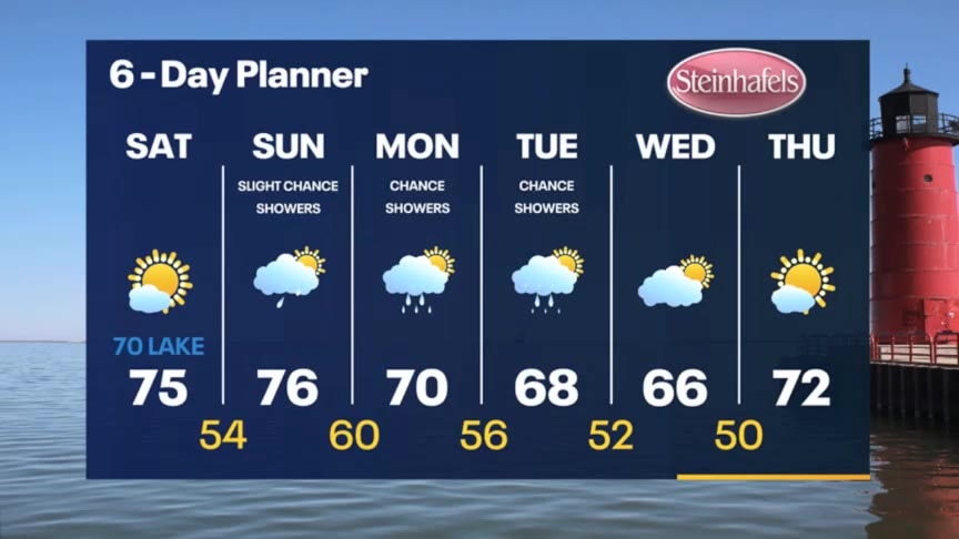
Partly cloudy skies tonight. Temps in the low to mid 50s Sunday morning. A northeast wind will keep things a little cooler near the lake Sunday. Highs in the low 70s with upper 60s near the lake. An approaching low will bring rain showers and a slight chance for thunderstorms later Sunday into Monday with lingering showers on Tuesday. We should return to sun and seasonal temperatures by late next week.
Partly cloudy skies tonight. Temps in the low to mid 50s Sunday morning. A northeast wind will keep things a little cooler near the lake Sunday. Highs in the low 70s with upper 60s near the lake. An approaching low will bring rain showers and a slight chance for thunderstorms later Sunday into Monday with lingering showers on Tuesday. We should return to sun and seasonal temperatures by late next week.

Weather webcast with Rob Haswell
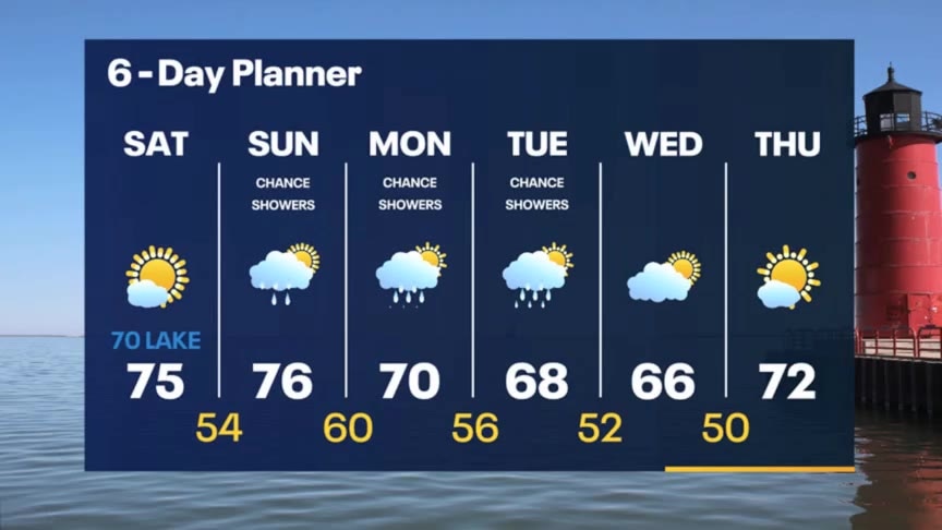
High pressure dominates the Great Lakes region again today with ample sunshine and highs warming slightly to the low to mid 70s. A northeast wind will keep things a little cooler near Lake Michigan today and again tomorrow. An approaching low will bring rain showers and a slight chance for thunderstorms later Sunday into Monday with lingering showers on Tuesday.
High pressure dominates the Great Lakes region again today with ample sunshine and highs warming slightly to the low to mid 70s. A northeast wind will keep things a little cooler near Lake Michigan today and again tomorrow. An approaching low will bring rain showers and a slight chance for thunderstorms later Sunday into Monday with lingering showers on Tuesday.
Weather Webcast with Stephanie Barichello
Sunny and pleasant Sunday then a slight chance for showers on Sunday. Better chance for rain Monday and Tuesday.
Sunny and pleasant Sunday then a slight chance for showers on Sunday. Better chance for rain Monday and Tuesday.
Weather Webcast with Stephanie Barichello
Clearing tonight and cooling into the 40s and 50s by morning! It'll be a refreshing start to the weekend! Sunny with highs in the 70s Saturday then a few showers will be possible at times Sunday. Better chance for rain Monday into Tuesday.
Clearing tonight and cooling into the 40s and 50s by morning! It'll be a refreshing start to the weekend! Sunny with highs in the 70s Saturday then a few showers will be possible at times Sunday. Better chance for rain Monday into Tuesday.

Weather webcast with Rob Haswell
High pressure builds over our area today bringing more dry air and eventually clearing things up with ample sun on the way by the weekend. For today we start cloudy with some patchy drizzle but should see some sunny breaks before the day is over and continue to clear overnight. A sunny Saturday with highs in the 70s kicks off our weekend. We get cloudier on Sunday with a slight chance for a few showers overnight but mostly dry during the day. A chance for showers and a slight chance of thunderstorms returns on Monday into Tuesday.
High pressure builds over our area today bringing more dry air and eventually clearing things up with ample sun on the way by the weekend. For today we start cloudy with some patchy drizzle but should see some sunny breaks before the day is over and continue to clear overnight. A sunny Saturday with highs in the 70s kicks off our weekend. We get cloudier on Sunday with a slight chance for a few showers overnight but mostly dry during the day. A chance for showers and a slight chance of thunderstorms returns on Monday into Tuesday.
Weather Webcast with Tom Wachs
Cloudy skies overnight with temperatures in the upper 50s to low 60s. Mostly cloudy on Friday with highs in the mid-to-upper 60s. 70s return this weekend.
Cloudy skies overnight with temperatures in the upper 50s to low 60s. Mostly cloudy on Friday with highs in the mid-to-upper 60s. 70s return this weekend.
Weather Webcast with Tom Wachs
Cloudy skies tonight with temperatures dropping through the 60s. Mostly cloudy and cool again on Friday with highs in the mid-to-upper 60s.
Cloudy skies tonight with temperatures dropping through the 60s. Mostly cloudy and cool again on Friday with highs in the mid-to-upper 60s.
Weather Webcast with Stephanie Barichello
Cloudy, cool and comfortable today with temperatures in the 60s. Similar Friday but the sunshine returns! We'll heat up a bit more over the weekend, especially Sunday, then cooling back into the 70s early next week.
Cloudy, cool and comfortable today with temperatures in the 60s. Similar Friday but the sunshine returns! We'll heat up a bit more over the weekend, especially Sunday, then cooling back into the 70s early next week.
Weather webcast with Rob Haswell
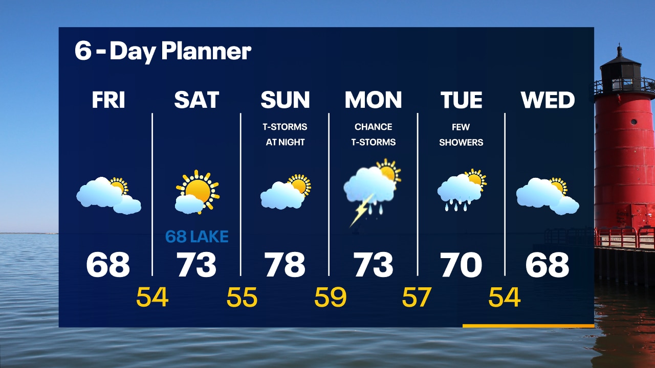
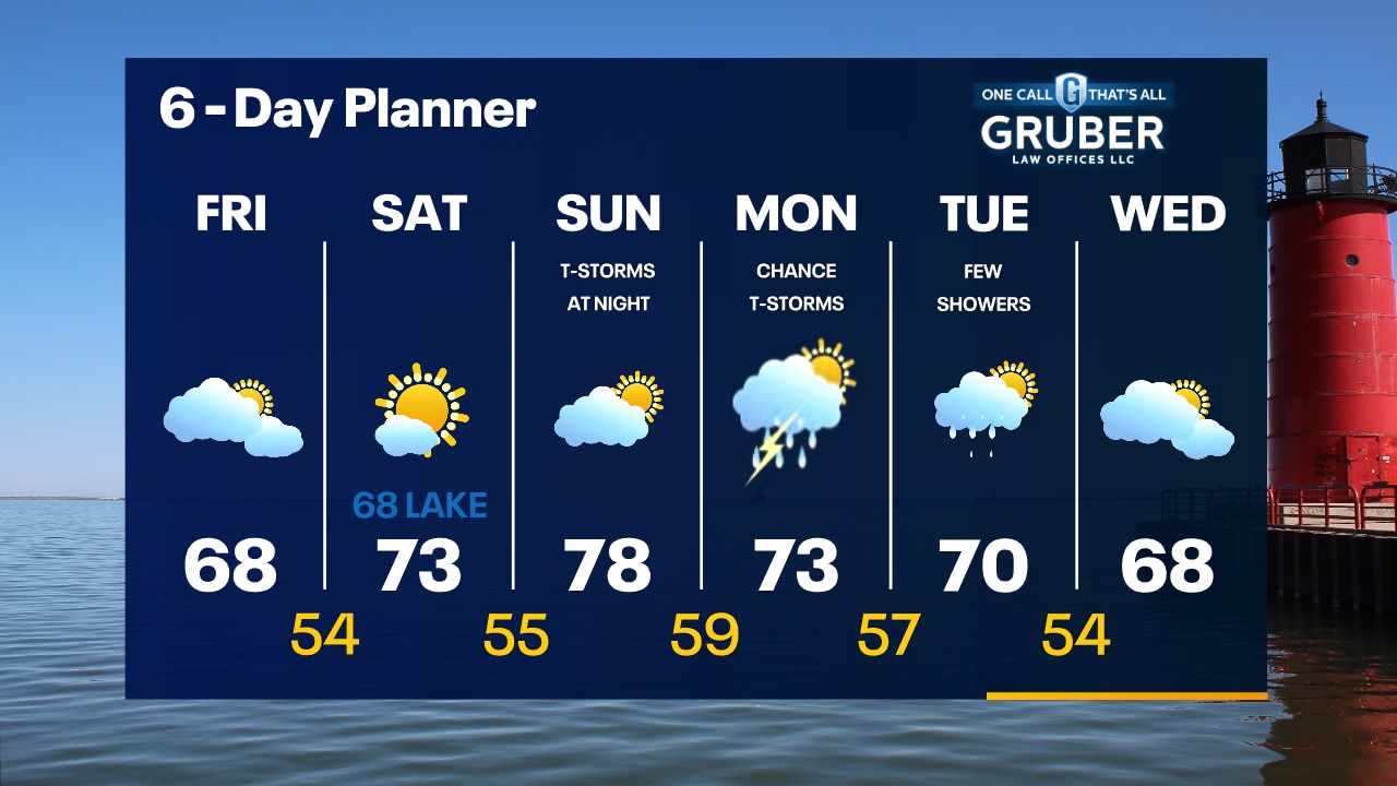
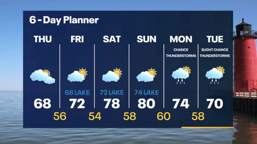
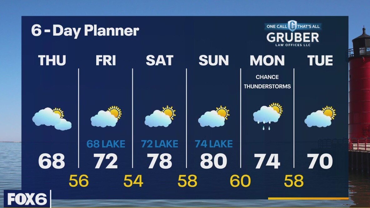
High pressure builds in today along with cooler and far less humid air. Temperatures fall into the mid to upper 60s this afternoon. We stay cloudy most of the day and clear overnight into Friday. Friday's highs will be slightly warmer - in the low 70s. We should return to the upper 70s and near 80 this weekend but a steady wind off the lake will keep us in the low 70s near Lake Michigan. Our next chance for rain arrives Monday and Tuesday.
High pressure builds in today along with cooler and far less humid air. Temperatures fall into the mid to upper 60s this afternoon. We stay cloudy most of the day and clear overnight into Friday. Friday's highs will be slightly warmer - in the low 70s. We should return to the upper 70s and near 80 this weekend but a steady wind off the lake will keep us in the low 70s near Lake Michigan. Our next chance for rain arrives Monday and Tuesday.