


Weather Webcast with Tom Wachs
Mostly cloudy tonight with a few off-and-on rain showers later this evening and overnight. This trend continues on Tuesday with highs in the upper 60s.
Mostly cloudy tonight with a few off-and-on rain showers later this evening and overnight. This trend continues on Tuesday with highs in the upper 60s.

Weather webcast with Lisa Michaels
An area of low pressure slowly moves from the NW to the SE over our area today and tomorrow bringing periods of rain and a few chances for thunderstorms. Highs today will be in the upper 60s to low 70s and cool to the mid to upper 60s Tuesday and Wednesday. We dry up by Thursday and temperatures start to warm up with highs returning to the upper 70s to near 80 by the weekend. Above average temperatures remain in place through early October.
An area of low pressure slowly moves from the NW to the SE over our area today and tomorrow bringing periods of rain and a few chances for thunderstorms. Highs today will be in the upper 60s to low 70s and cool to the mid to upper 60s Tuesday and Wednesday. We dry up by Thursday and temperatures start to warm up with highs returning to the upper 70s to near 80 by the weekend. Above average temperatures remain in place through early October.

Weather webcast with Rob Haswell
An area of low pressure slowly moves from the NW to the SE over our area today and tomorrow bringing periods of rain and a few chances for thunderstorms. Highs today will be in the upper 60s to low 70s and cool to the mid to upper 60s Tuesday and Wednesday. We dry up by Thursday and temperatures start to warm up with highs returning to the upper 70s to near 80 by the weekend. Above average temperatures remain in place through early October.
An area of low pressure slowly moves from the NW to the SE over our area today and tomorrow bringing periods of rain and a few chances for thunderstorms. Highs today will be in the upper 60s to low 70s and cool to the mid to upper 60s Tuesday and Wednesday. We dry up by Thursday and temperatures start to warm up with highs returning to the upper 70s to near 80 by the weekend. Above average temperatures remain in place through early October.

Weather Webcast with Tom Wachs
A few rain showers are possible overnight with temperatures in the 60s. Spotty rain showers continue in the forecast Monday, otherwise mostly cloudy with a high around 70.
A few rain showers are possible overnight with temperatures in the 60s. Spotty rain showers continue in the forecast Monday, otherwise mostly cloudy with a high around 70.

Weather Webcast with Tom Wachs
Mostly cloudy tonight with a few rain showers possible overnight. Temperatures dropping through the 60s. Mostly cloudy on Monday with a slight chance for rain showers. High around 70.
Mostly cloudy tonight with a few rain showers possible overnight. Temperatures dropping through the 60s. Mostly cloudy on Monday with a slight chance for rain showers. High around 70.

Weather Webcast with Meteorologist Lisa Michaels
Partly cloudy skies Sunday with highs in the low 70s. A few showers possible this afternoon especially in areas closer to I-90. Due to a cut-off low, additional rain chances are possible Monday through early Wednesday next week.
Partly cloudy skies Sunday with highs in the low 70s. A few showers possible this afternoon especially in areas closer to I-90. Due to a cut-off low, additional rain chances are possible Monday through early Wednesday next week.

Weather Webcast with Meteorologist Eric Manges
Cloudy to end the weekend and start next week but a couple rain chances
Cloudy to end the weekend and start next week but a couple rain chances

Weather Webcast with Meteorologist Lisa Michaels
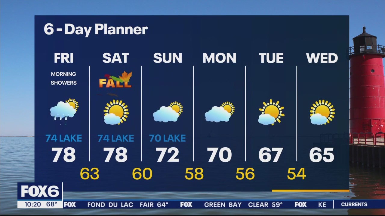
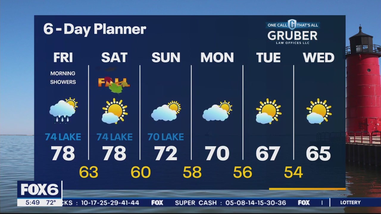
Stray morning drizzle or showers possible. Decreasing clouds today into partly cloudy/mostly sunny skies. Highs in the low to mid 70s Saturday. 70F near the lake with a southeast wind 5-10mph. Spotty rain potential Sunday through Wednesday next week.
Stray morning drizzle or showers possible. Decreasing clouds today into partly cloudy/mostly sunny skies. Highs in the low to mid 70s Saturday. 70F near the lake with a southeast wind 5-10mph. Spotty rain potential Sunday through Wednesday next week.

Weather Webcast with Meteorologist Eric Manges
Fall color is still a few weeks away but peaks of it are showing up North
Fall color is still a few weeks away but peaks of it are showing up North

Weather Webcast with Meteorologist Eric Manges
How in the world did Flamingos end up in Wisconsin? Hurricane Idalia the likely cause.
How in the world did Flamingos end up in Wisconsin? Hurricane Idalia the likely cause.

Weather Webcast with Stephanie Barichello
Partly sunny this afternoon with some rain passing west of us. Similar conditions Saturday and Sunday, although temperatures will cool a bit by Sunday. Pleasant next week.
Partly sunny this afternoon with some rain passing west of us. Similar conditions Saturday and Sunday, although temperatures will cool a bit by Sunday. Pleasant next week.
Weather webcast with Rob Haswell
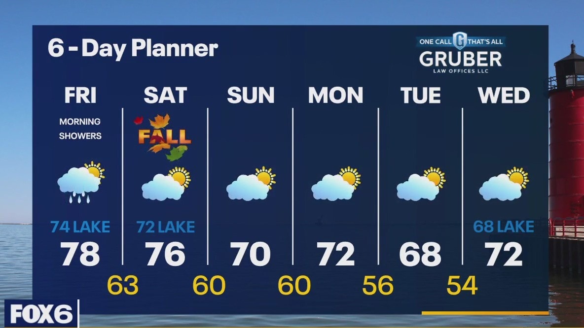
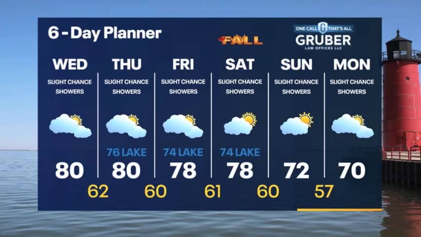
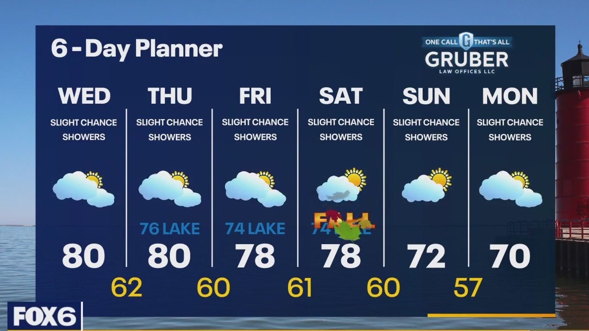
We spend the next few days between two larger areas of low pressure with a narrow ridge or high pressure in between. After a few showers this morning we dry up and should stay mostly dry through the weekend. Temperatures will be in the mid to upper 70s inland and low 70s lakeside today and tomorrow and then fall to the upper 60s and low 70s early next week. Warmer than average air returns late next week into early October.
We spend the next few days between two larger areas of low pressure with a narrow ridge or high pressure in between. After a few showers this morning we dry up and should stay mostly dry through the weekend. Temperatures will be in the mid to upper 70s inland and low 70s lakeside today and tomorrow and then fall to the upper 60s and low 70s early next week. Warmer than average air returns late next week into early October.
Weather Webcast with Meteorologist Eric Manges
Few showers tonight but we start off fall on a warm note
Few showers tonight but we start off fall on a warm note
Weather Webcast with Meteorologist Eric Manges
Warm into the weekend but starting Fall on the cooler side of things next week
Warm into the weekend but starting Fall on the cooler side of things next week
Weather webcast wit Rob Haswell
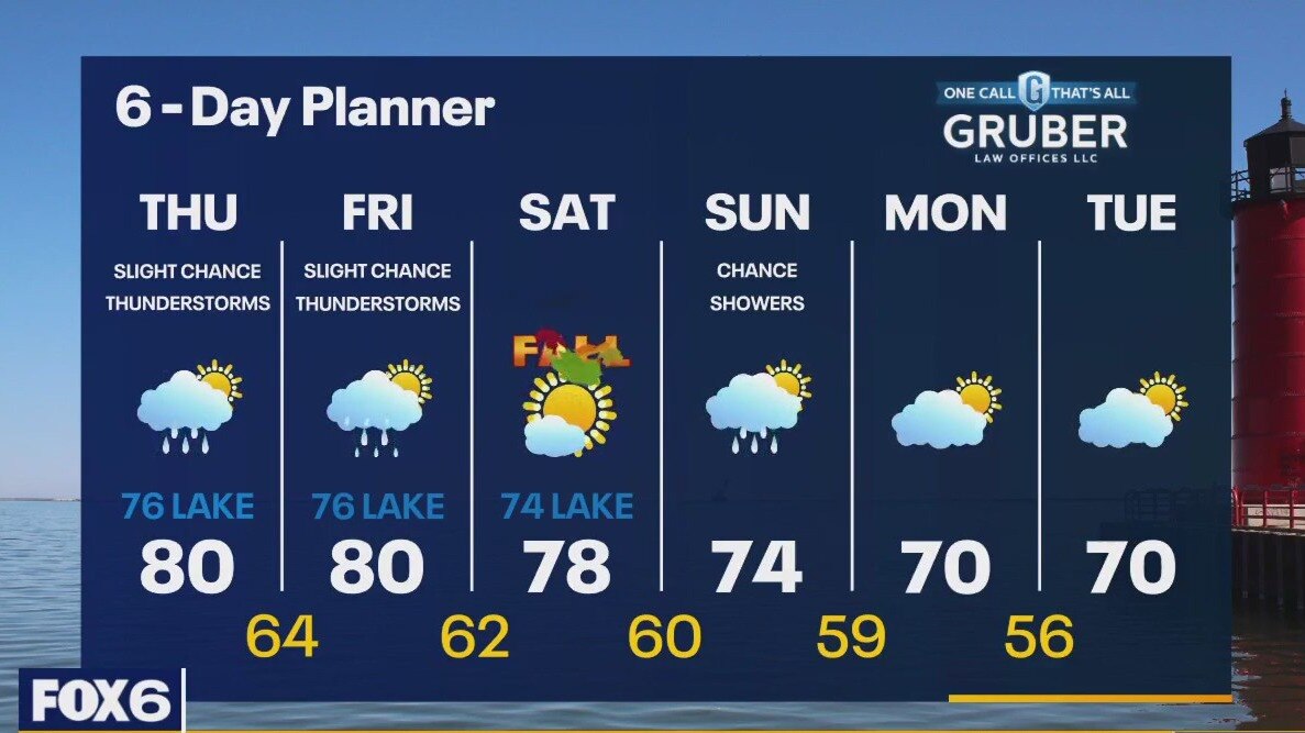
Mostly cloudy today but warm with highs in the upper 70s and low 80s. Cooler conditions are expected lakeside with a breeze off Lake Michigan. Showers are possible today - particularly south of I-94. There is a slight chance for thunderstorms. We continue with a chance for showers tonight into tomorrow morning but should dry up Friday afternoon and evening. Highs on Friday will again reach near 80 with cooler conditions lakeside. We stay warm and humid through Saturday but start to cool Sunday and into early next week.
Mostly cloudy today but warm with highs in the upper 70s and low 80s. Cooler conditions are expected lakeside with a breeze off Lake Michigan. Showers are possible today - particularly south of I-94. There is a slight chance for thunderstorms. We continue with a chance for showers tonight into tomorrow morning but should dry up Friday afternoon and evening. Highs on Friday will again reach near 80 with cooler conditions lakeside. We stay warm and humid through Saturday but start to cool Sunday and into early next week.
Weather Webcast with Tom Wachs
Mostly cloudy overnight with temperatures falling through the 60s. Mostly cloudy on Thursday with a slight chance for a t-storm. Highs around 80 inland, upper 70s near the lake.
Mostly cloudy overnight with temperatures falling through the 60s. Mostly cloudy on Thursday with a slight chance for a t-storm. Highs around 80 inland, upper 70s near the lake.
Weather Webcast with Tom Wachs
Mostly cloudy tonight with temperatures dropping into the 60s. Mostly cloudy with a slight chance for a t-storm on Thursday. High around 80 inland, upper 70s near the lake.
Mostly cloudy tonight with temperatures dropping into the 60s. Mostly cloudy with a slight chance for a t-storm on Thursday. High around 80 inland, upper 70s near the lake.
Weather Webcast with Stephanie Barichello
A stray shower or thunderstorm will be possible today and throughout the extended forecast. Temperatures will be warmer, in the 70s and 80s, through the rest of the week. Cooling to more normal numbers by the weekend.
A stray shower or thunderstorm will be possible today and throughout the extended forecast. Temperatures will be warmer, in the 70s and 80s, through the rest of the week. Cooling to more normal numbers by the weekend.
Weather webcast with Rob Haswell
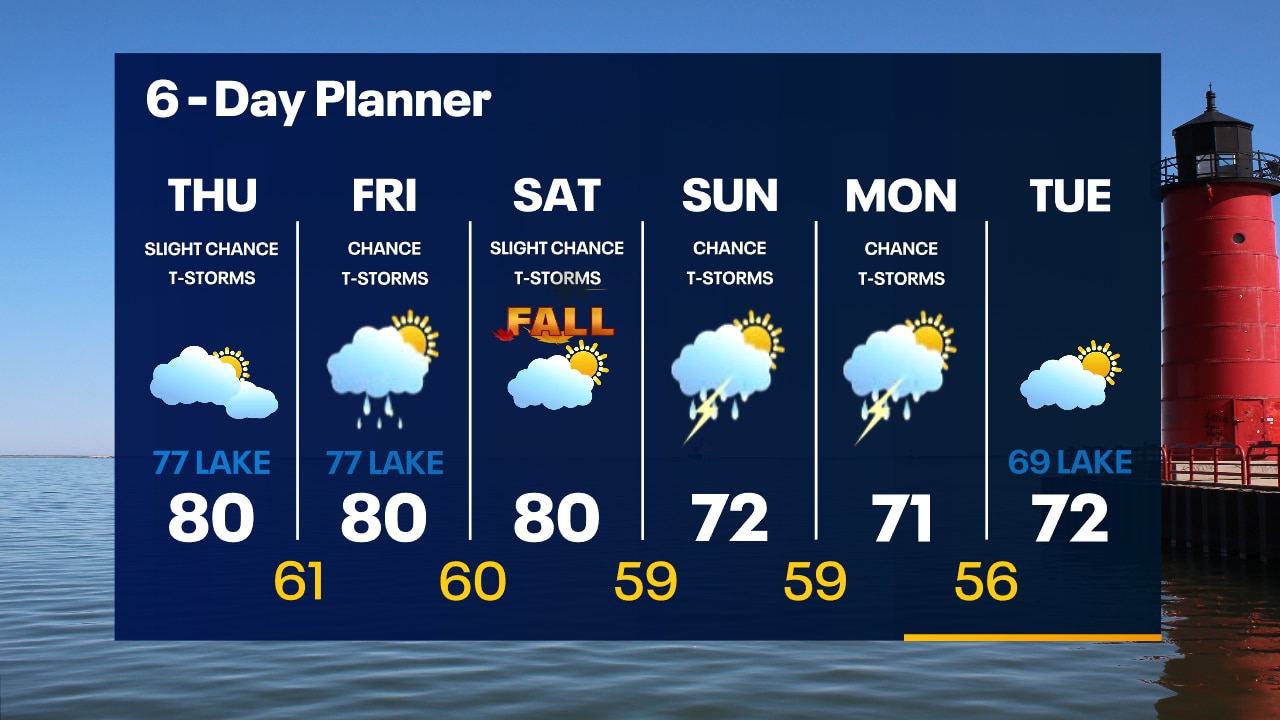
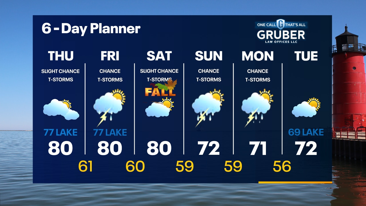
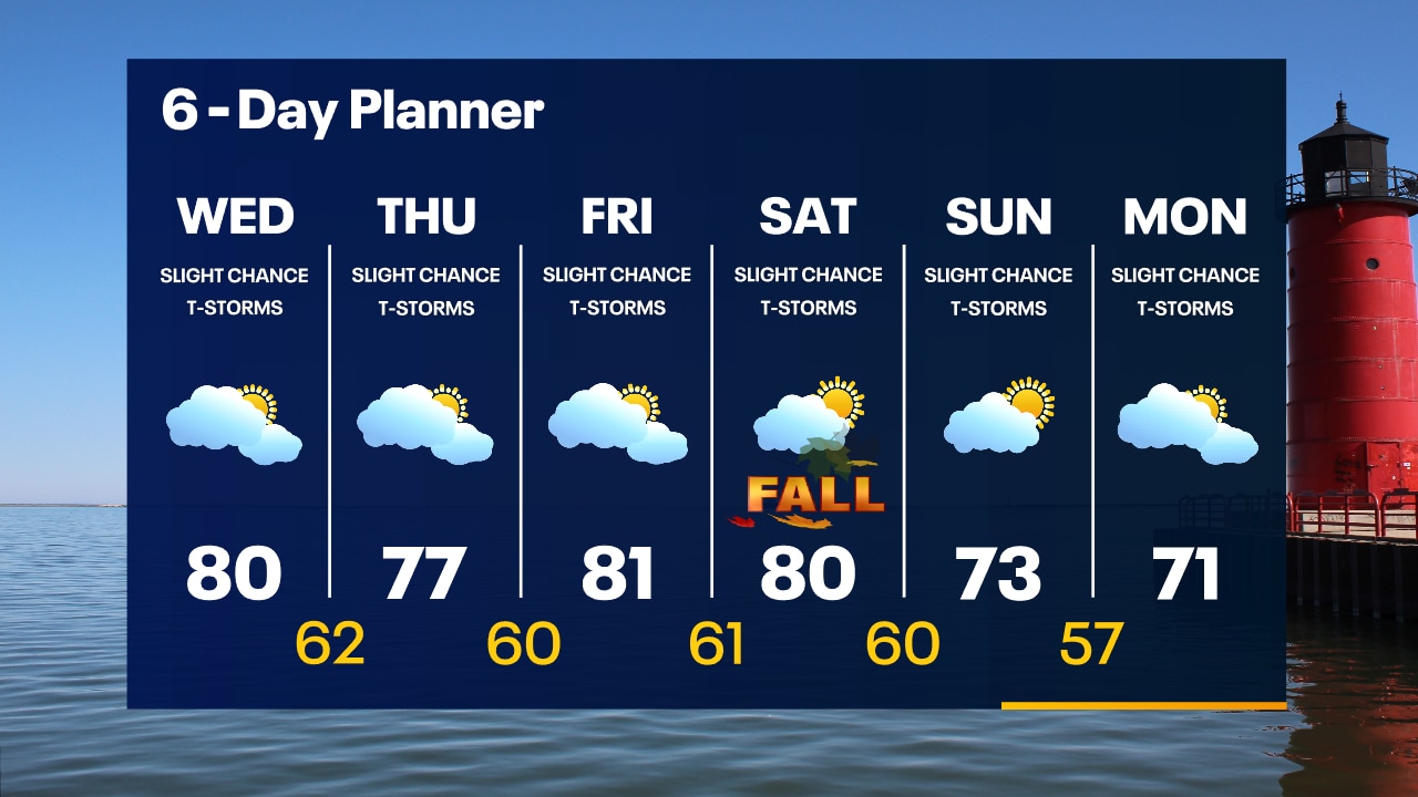
We are behind a warm front today with highs surging to near 80 after spending 3 days in the 60s. The atmosphere will be somewhat unstable for the next few days with a slight chance for showers or thunderstorms today through the weekend. Temperatures will stay above average through Saturday and then cool slightly early next week. Warmer air looks to return next week.
We are behind a warm front today with highs surging to near 80 after spending 3 days in the 60s. The atmosphere will be somewhat unstable for the next few days with a slight chance for showers or thunderstorms today through the weekend. Temperatures will stay above average through Saturday and then cool slightly early next week. Warmer air looks to return next week.
Weather Webcast with Tom Wachs
Partly cloudy overnight with temperatures in the 50s. Mostly cloudy, warm and humid on Wednesday with a high around 80. Only a slight chance for a t-storm.
Partly cloudy overnight with temperatures in the 50s. Mostly cloudy, warm and humid on Wednesday with a high around 80. Only a slight chance for a t-storm.