

Weather Webcast with Meteorologist Stephanie Barichello
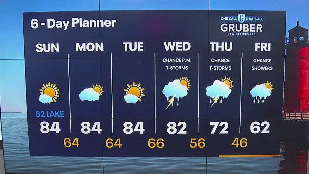
Sunny, warm and a bit humid again today. Temperatures will top out in the low 80s, coolest lakeside. We drop into the 60s tonight then jump back into the 80s again Monday into Tuesday. Clouds increase Wednesday and rain is possible late in the day. There is also a chance for showers Thursday and Friday.
Sunny, warm and a bit humid again today. Temperatures will top out in the low 80s, coolest lakeside. We drop into the 60s tonight then jump back into the 80s again Monday into Tuesday. Clouds increase Wednesday and rain is possible late in the day. There is also a chance for showers Thursday and Friday.
Weather Webcast with Tom Wachs
Mostly clear to partly cloudy overnight with temperatures in the 60s. Another warm and humid day Sunday with mostly sunny skies and highs in the 80s. It will turn cooler near the lake in the afternoon.
Mostly clear to partly cloudy overnight with temperatures in the 60s. Another warm and humid day Sunday with mostly sunny skies and highs in the 80s. It will turn cooler near the lake in the afternoon.

Weather Webcast with Tom Wachs
Mostly clear tonight with temperatures dropping through the 60s. Mostly sunny, warm and humid again on Sunday with highs in the 80s.
Mostly clear tonight with temperatures dropping through the 60s. Mostly sunny, warm and humid again on Sunday with highs in the 80s.
Weather Webcast with Meteorologist Lisa Michaels
Morning temps in the 50s with patchy fog starting Saturday. Mostly sunny skies this weekend with high temps in the low 80s. October begins Sunday-temps will be 10F to 15F at least above average heading into the first week of the month.
Morning temps in the 50s with patchy fog starting Saturday. Mostly sunny skies this weekend with high temps in the low 80s. October begins Sunday-temps will be 10F to 15F at least above average heading into the first week of the month.
Weather Webcast with Stephanie Barichello
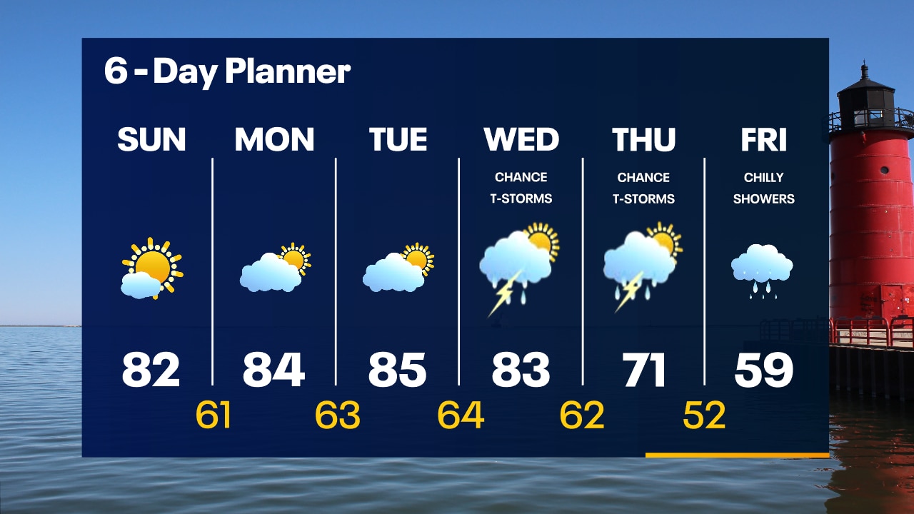
Unseasonably warm temperatures on the way this weekend with some humidity. Next chance for rain arrives late Wednesday, which will then drop temperatures back to normal Thursday.
Unseasonably warm temperatures on the way this weekend with some humidity. Next chance for rain arrives late Wednesday, which will then drop temperatures back to normal Thursday.
Weather webcast with Lisa Michaels
Partly cloudy Friday turning to partly sunny during the afternoon. Highs in the low to mid 70s. Above average temps return to the 80s this weekend and into the first week of October. Chance of rain next Wednesday followed by a big cool down!
Partly cloudy Friday turning to partly sunny during the afternoon. Highs in the low to mid 70s. Above average temps return to the 80s this weekend and into the first week of October. Chance of rain next Wednesday followed by a big cool down!
Weather webcast with Lisa Michaels
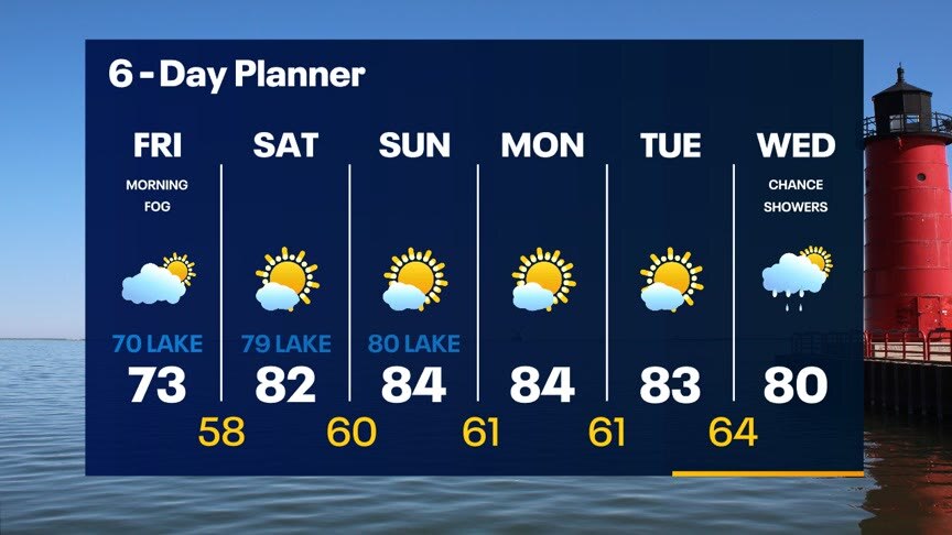
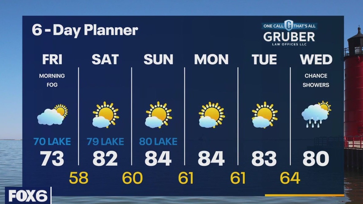
Patchy to dense fog this morning especially for inland areas. Dense fog advisory until 10 a.m.. Partly cloudy Friday turning to partly sunny during the afternoon. Highs in the low to mid 70s. Above average temps return to the 80s this weekend and into the first week of October. Chance of rain next Wednesday followed by a big cool down!
Patchy to dense fog this morning especially for inland areas. Dense fog advisory until 10 a.m.. Partly cloudy Friday turning to partly sunny during the afternoon. Highs in the low to mid 70s. Above average temps return to the 80s this weekend and into the first week of October. Chance of rain next Wednesday followed by a big cool down!
Weather Webcast with Tom Wachs
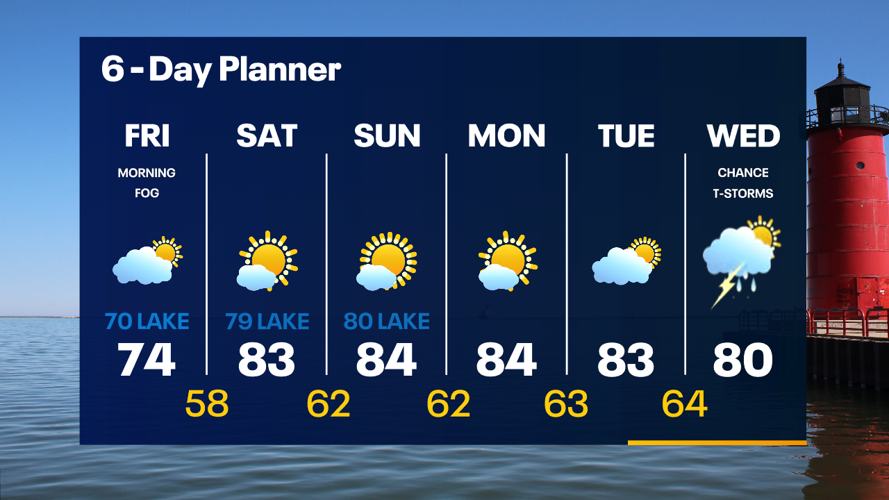
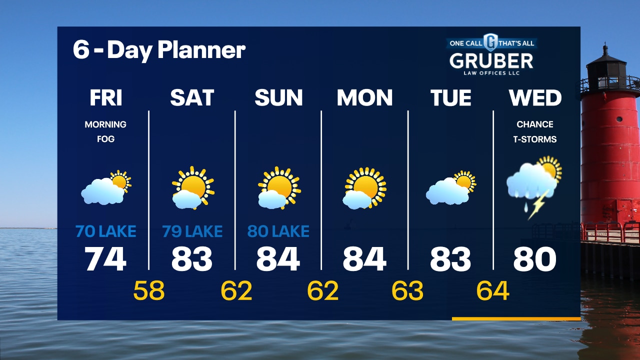
Areas of dense fog away from the lake overnight with temperatures in the 50s. Morning fog on Friday otherwise partly sunny with highs in the low-to-mid 70s, coolest near the lake.
Areas of dense fog away from the lake overnight with temperatures in the 50s. Morning fog on Friday otherwise partly sunny with highs in the low-to-mid 70s, coolest near the lake.
Weather Webcast with Tom Wachs
Clearing skies tonight with temperatures dropping into the 50s. Dense fog is possible inland overnight. Partly sunny on Friday with highs in the 70s. 80s return this weekend.
Clearing skies tonight with temperatures dropping into the 50s. Dense fog is possible inland overnight. Partly sunny on Friday with highs in the 70s. 80s return this weekend.
Weather Webcast with Stephanie Barichello
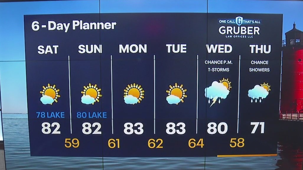
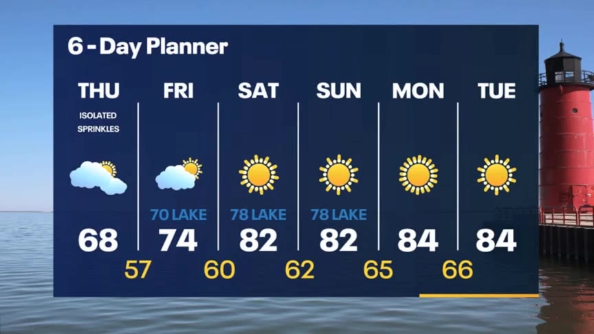
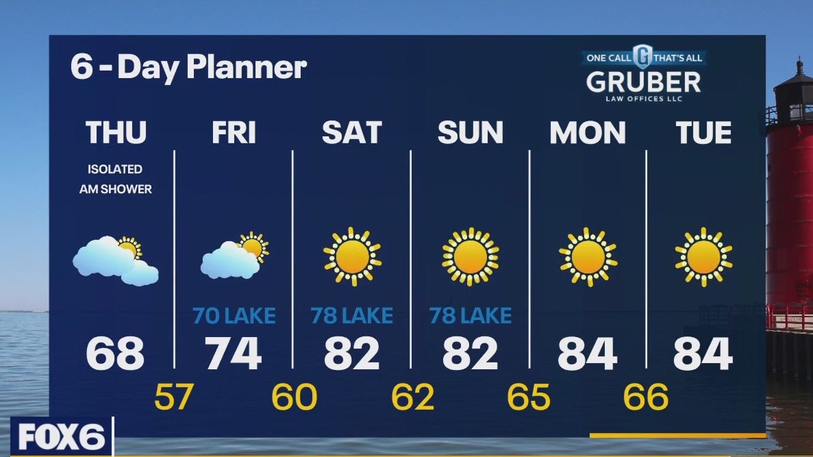
Sprinkles end today but we stay mostly cloudy. Better chance for some sunshine Friday and especially over the weekend. Warming up big time by the weekend with 80s both days, which will last through early next week.
Sprinkles end today but we stay mostly cloudy. Better chance for some sunshine Friday and especially over the weekend. Warming up big time by the weekend with 80s both days, which will last through early next week.
Weather webcast with Rob Haswell
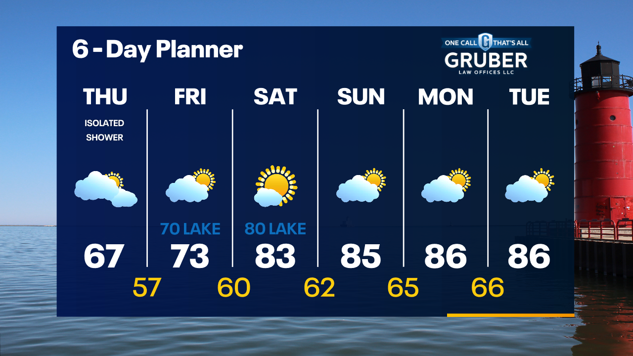
We finally get behind that persistent low today with slowly clearing conditions. Temperatures remain on the cooler side with highs in the upper 60s today but will warm steadily in the days ahead. We should be in the upper 70s and low 80s through the weekend and into the middle of next week. We stay mostly dry for several days.
We finally get behind that persistent low today with slowly clearing conditions. Temperatures remain on the cooler side with highs in the upper 60s today but will warm steadily in the days ahead. We should be in the upper 70s and low 80s through the weekend and into the middle of next week. We stay mostly dry for several days.

Weather Webcast with Tom Wachs
Patchy fog overnight with an isolated rain shower possible. Mostly cloudy and cool again on Thursday with a stray rain shower possible. Highs in the 60s.
Patchy fog overnight with an isolated rain shower possible. Mostly cloudy and cool again on Thursday with a stray rain shower possible. Highs in the 60s.
Weather Webcast with Tom Wachs
Scattered light rain showers this evening tapering off overnight. Patchy fog overnight as well. An isolated shower is possible Thursday but the big story is the weekend warm up.
Scattered light rain showers this evening tapering off overnight. Patchy fog overnight as well. An isolated shower is possible Thursday but the big story is the weekend warm up.

Weather Webcast with Stephanie Barichello
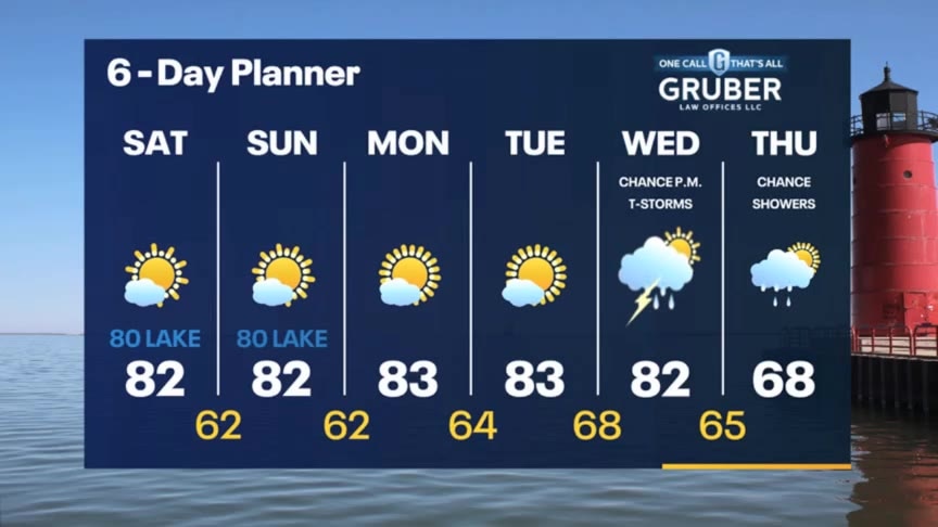
Scattered showers continue today then we dry out Thursday. Sunny Friday into the weekend and really warming up. 80s expected by Saturday.
Scattered showers continue today then we dry out Thursday. Sunny Friday into the weekend and really warming up. 80s expected by Saturday.
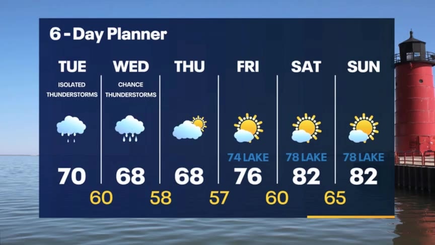
Weather webcast with Rob Haswell
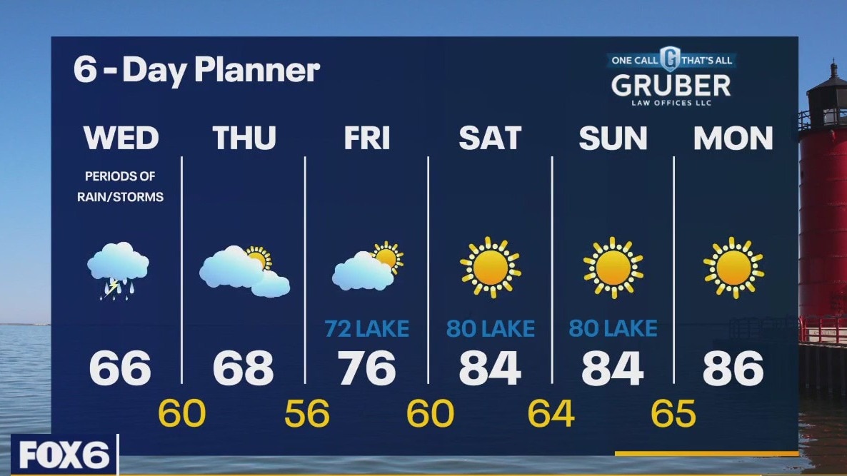
Another wet day with rounds of rain and a chance for thunderstorms. We will be cooler today with highs in the low to mid 60s. A strong SE-E wind will cause high waves and strong currents resulting in a Beach Hazards Statement until 10pm. We dry up after a few early showers Thursday and start warming up Friday with highs returning to the 80s by the weekend. We stay much warmer than average through the middle of next week.
Another wet day with rounds of rain and a chance for thunderstorms. We will be cooler today with highs in the low to mid 60s. A strong SE-E wind will cause high waves and strong currents resulting in a Beach Hazards Statement until 10pm. We dry up after a few early showers Thursday and start warming up Friday with highs returning to the 80s by the weekend. We stay much warmer than average through the middle of next week.
Weather Webcast with Tom Wachs
Scattered showers and a few rumbles of thunder overnight. Temperatures in the 60s. Another day with scattered showers and t-storms on Wednesday with highs in the 60s.
Scattered showers and a few rumbles of thunder overnight. Temperatures in the 60s. Another day with scattered showers and t-storms on Wednesday with highs in the 60s.
Weather Webcast with Tom Wachs
Scattered showers and t-storms will redevelop over Lake Michigan later tonight and move northwest into our area. Scattered showers and t-storms continue in the forecast on Wednesday.
Scattered showers and t-storms will redevelop over Lake Michigan later tonight and move northwest into our area. Scattered showers and t-storms continue in the forecast on Wednesday.
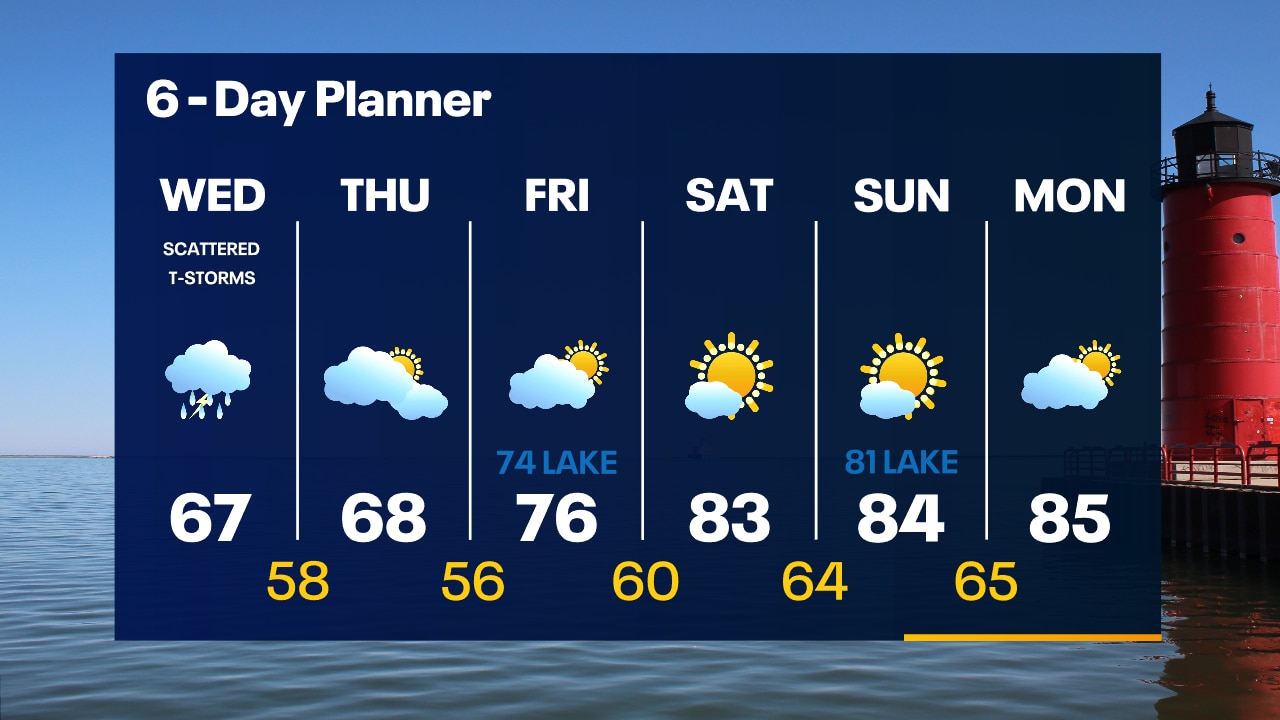
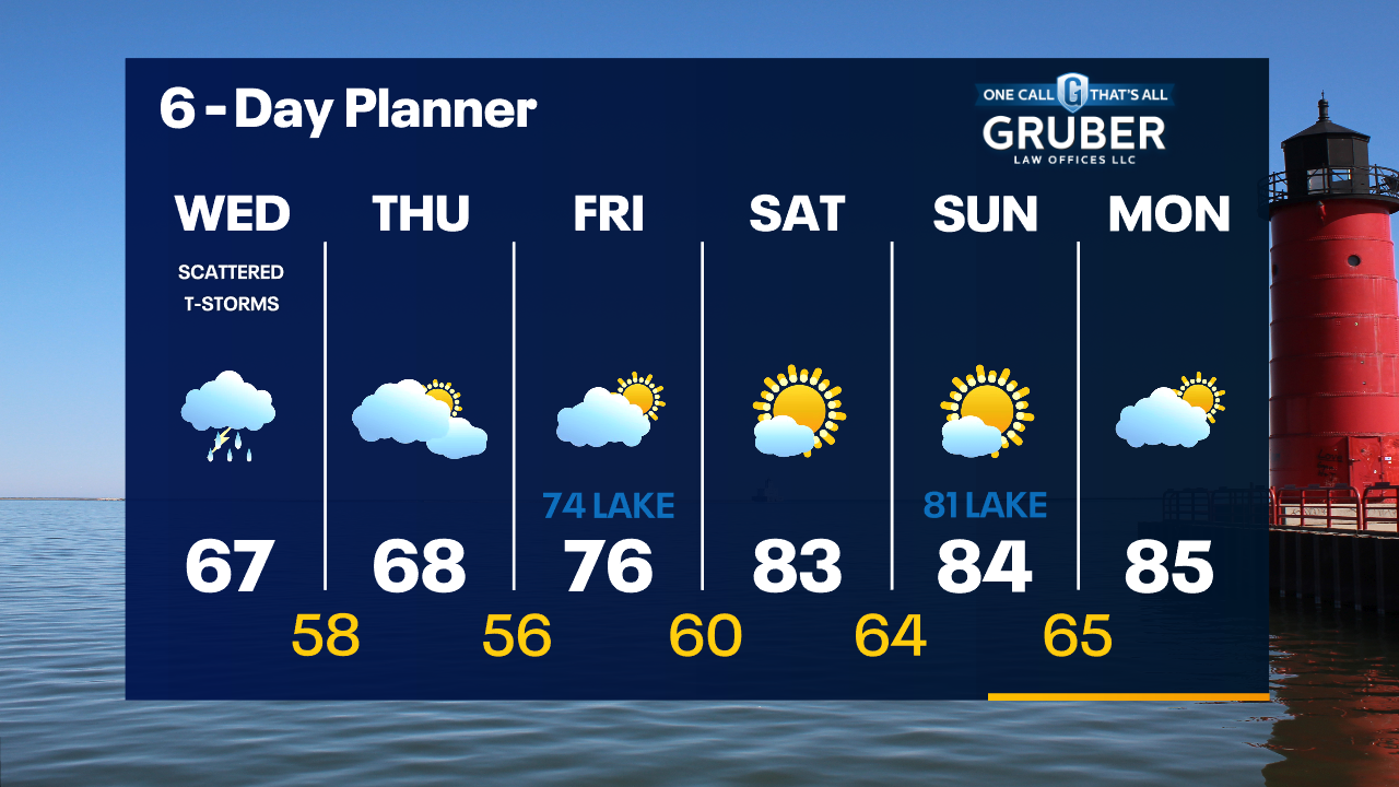
Weather Webcast with Stephanie Barichello
Scattered showers expected this afternoon and evening with temperatures around 70. Another soggy and dreary day Wednesday then improving conditions Thursday. Warming by the weekend with 80s inland.
Scattered showers expected this afternoon and evening with temperatures around 70. Another soggy and dreary day Wednesday then improving conditions Thursday. Warming by the weekend with 80s inland.
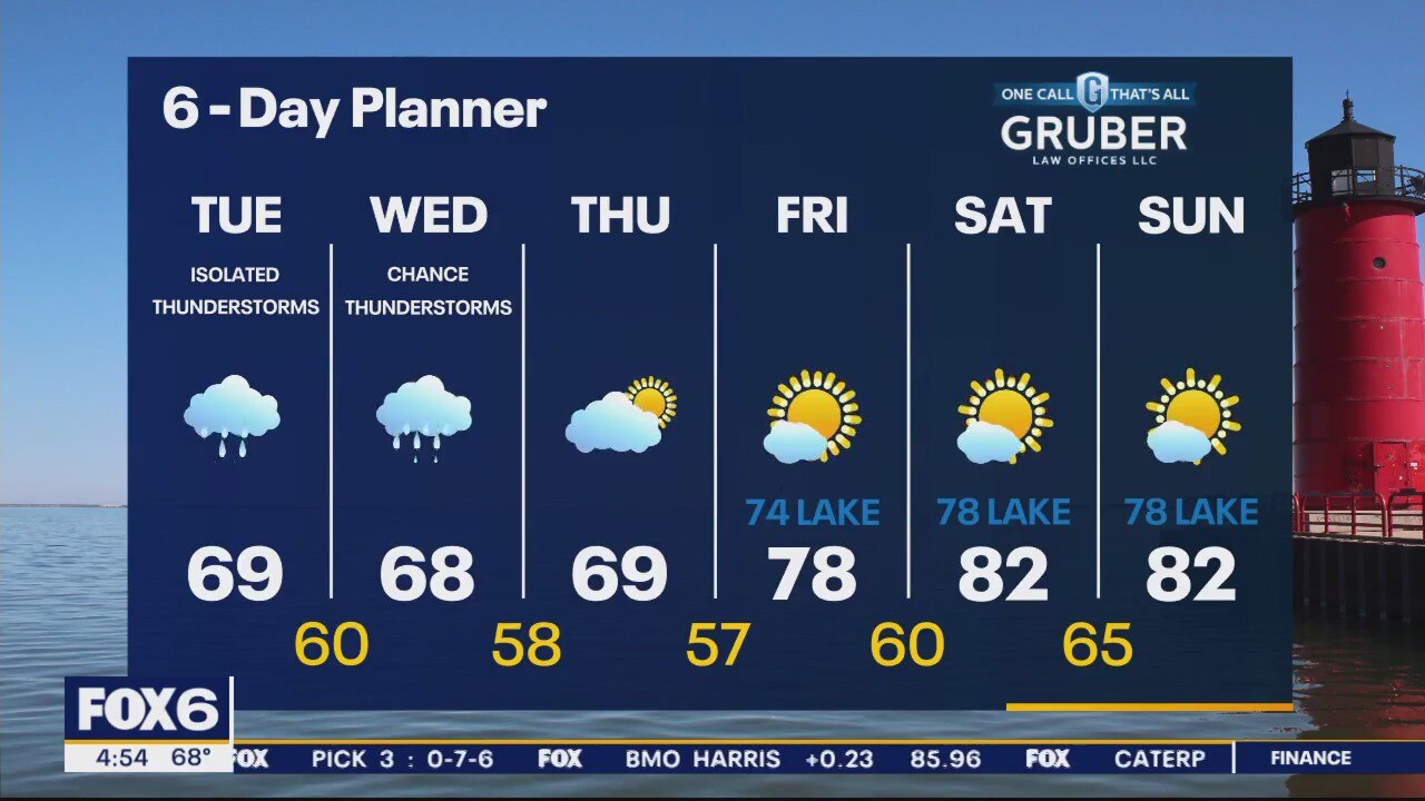
Weather webcast with Rob Haswell
Another day with this slow-moving low-pressure system. Periods of rain and thunderstorms are likely. Highs today will be in the upper 60s to near 70. The breeze will pick up out of the SE and will generate high waves and strong currents. A Beach Hazards Statement goes into effect this evening through Wednesday evening. More showers on Wednesday then drying up and warming up by the weekend!
Another day with this slow-moving low-pressure system. Periods of rain and thunderstorms are likely. Highs today will be in the upper 60s to near 70. The breeze will pick up out of the SE and will generate high waves and strong currents. A Beach Hazards Statement goes into effect this evening through Wednesday evening. More showers on Wednesday then drying up and warming up by the weekend!
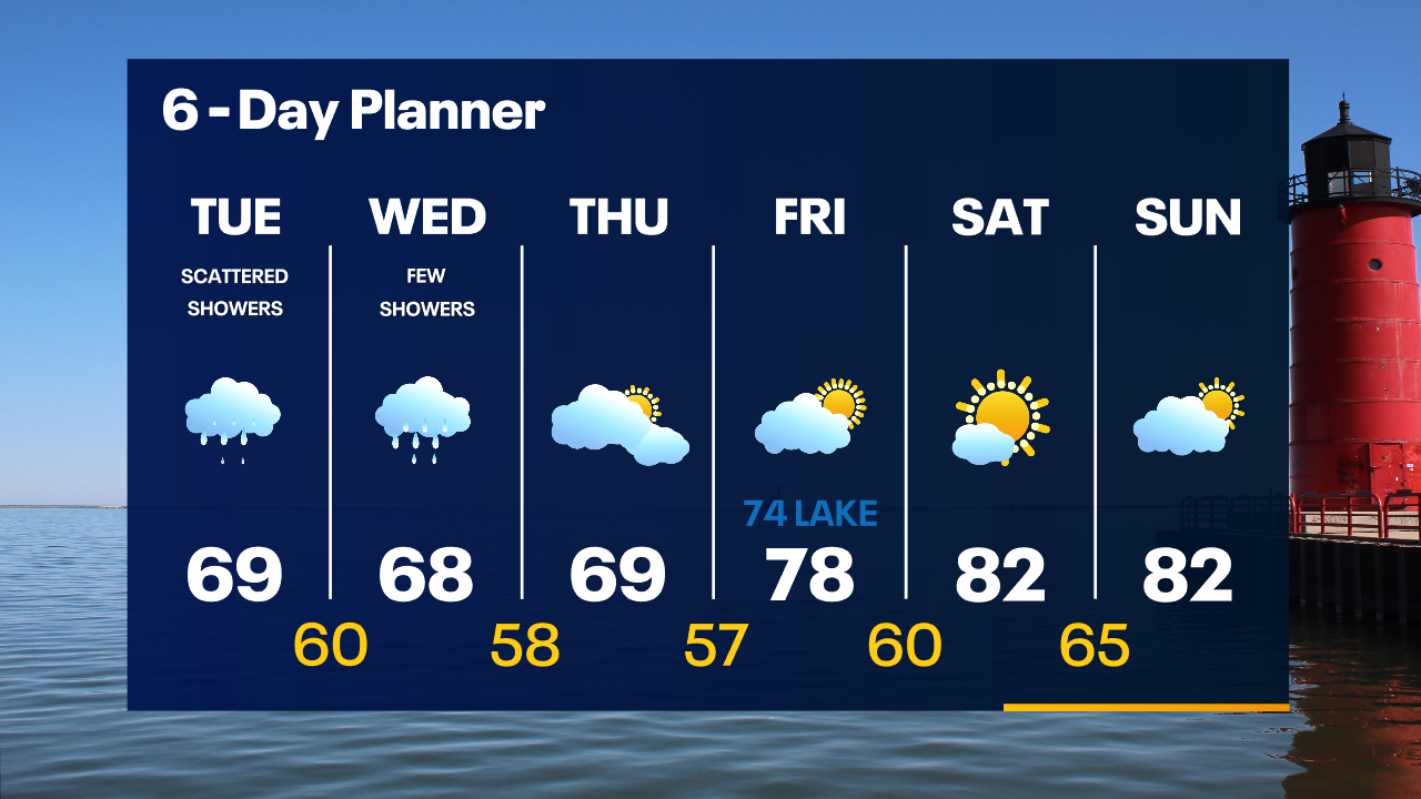
Weather Webcast with Tom Wachs
Soggy conditions Tuesday morning with spotty showers Tuesday afternoon. Highs in the upper 60s. A few more rain showers are possible Wednesday before the sun returns late in the week.
Soggy conditions Tuesday morning with spotty showers Tuesday afternoon. Highs in the upper 60s. A few more rain showers are possible Wednesday before the sun returns late in the week.