

Weather webcast with Rob Haswell
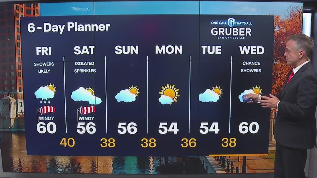
We are now behind the last of the two cold fronts with the main low pressure system to our far north. This low has become what is known as a "cut-off" low meaning it will sit nearly station for a while and spring in periods of showers later today and possibly sprinkles tomorrow. Highs will fall into the 50s and near 60 today and stay in the mid 50s for the weekend. Sun takes over for Monday giving us a sunny holiday but clearer conditions increase the risk for front - mostly inland - from Sunday night through Tuesday night.
We are now behind the last of the two cold fronts with the main low pressure system to our far north. This low has become what is known as a "cut-off" low meaning it will sit nearly station for a while and spring in periods of showers later today and possibly sprinkles tomorrow. Highs will fall into the 50s and near 60 today and stay in the mid 50s for the weekend. Sun takes over for Monday giving us a sunny holiday but clearer conditions increase the risk for front - mostly inland - from Sunday night through Tuesday night.
Weather Webcast with Tom Wachs
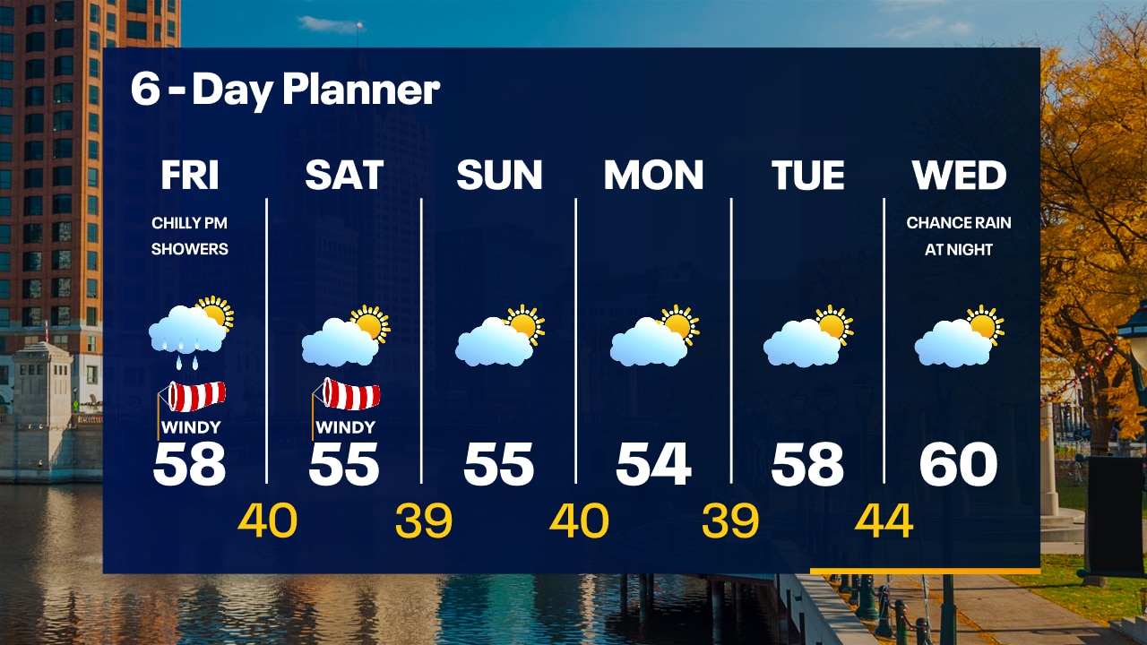
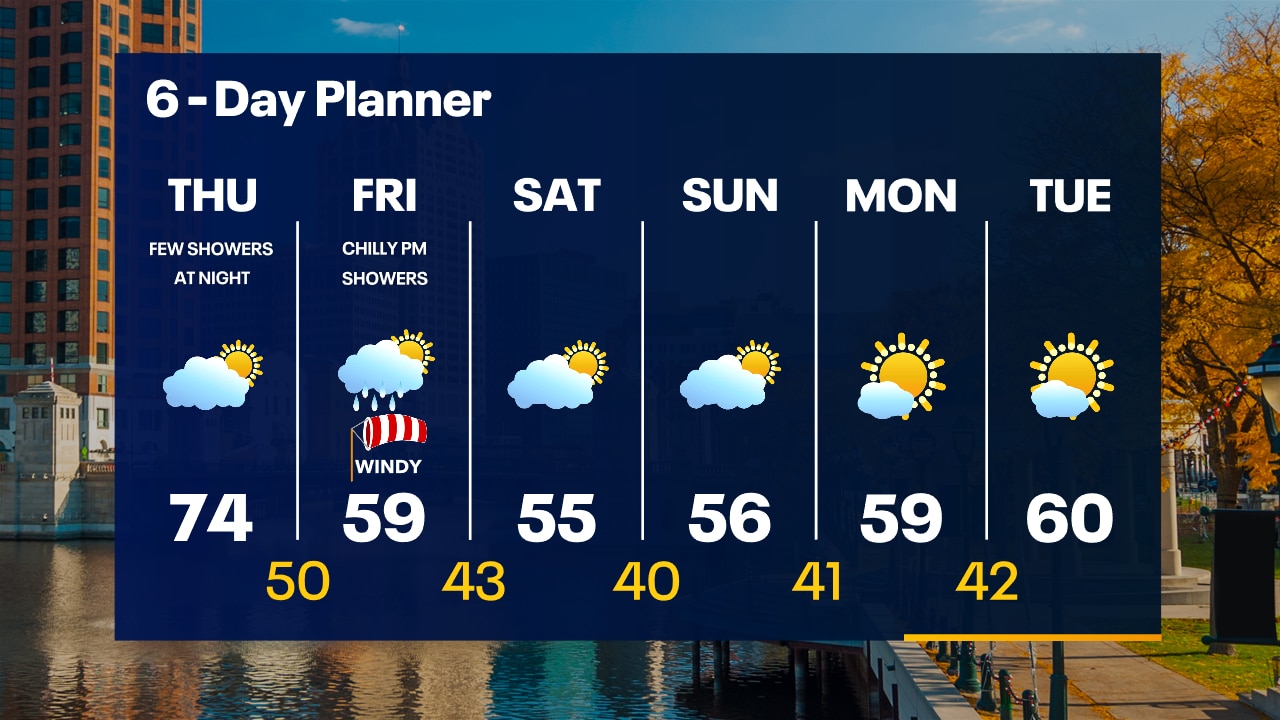
Clearing skies overnight with temperatures dropping into the 40s by sunrise. Morning sun and afternoon rain showers Friday. Windy and cool with highs in the 50s.
Clearing skies overnight with temperatures dropping into the 40s by sunrise. Morning sun and afternoon rain showers Friday. Windy and cool with highs in the 50s.
Weather Webcast with Tom Wachs
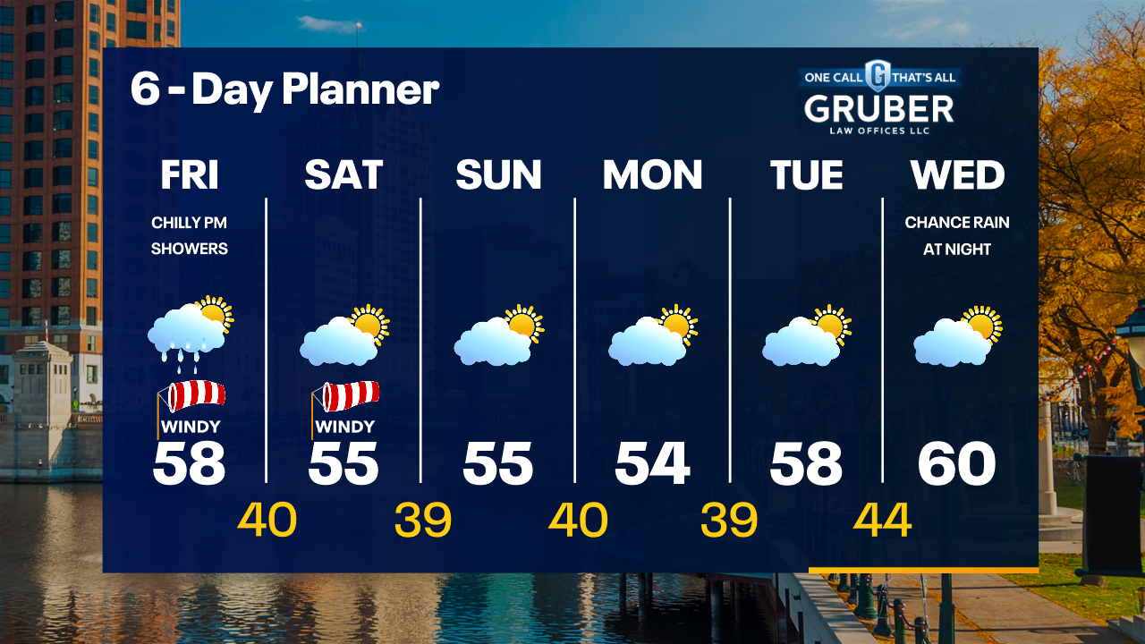
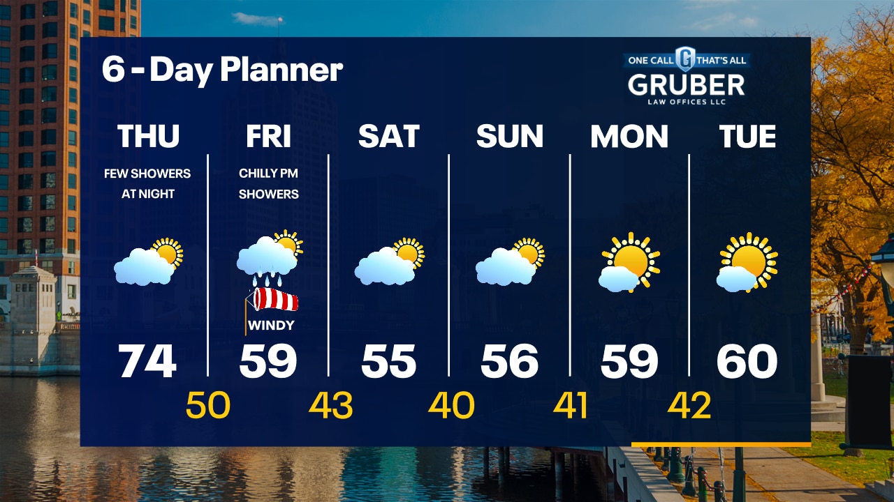
A few spotty rain showers are possible through 10pm otherwise partly cloudy overnight. Temperatures dropping into the 40s overnight. AM Sun/PM showers on Friday with a blustery high in the 50s.
A few spotty rain showers are possible through 10pm otherwise partly cloudy overnight. Temperatures dropping into the 40s overnight. AM Sun/PM showers on Friday with a blustery high in the 50s.
Weather Webcast with Stephanie Barichello
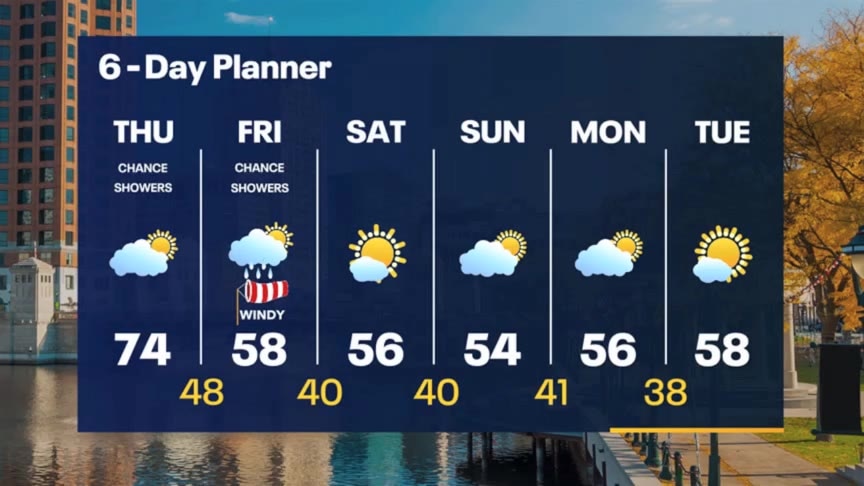
Partly sunny today with temperatures in the 70s then we drop into the 50s starting tomorrow, and lasting through the extended forecast. There is a chance for rain Friday then a nice stretch of sunshine.
Partly sunny today with temperatures in the 70s then we drop into the 50s starting tomorrow, and lasting through the extended forecast. There is a chance for rain Friday then a nice stretch of sunshine.
Weather webcast with Rob Haswell
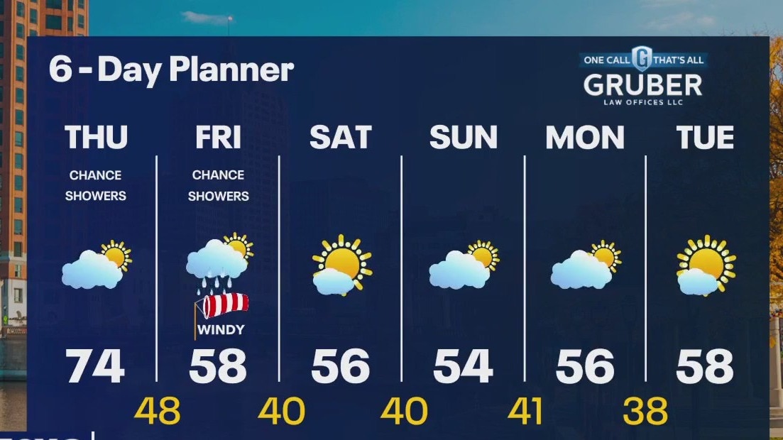
The first of two cold fronts is laying across far SE Wisconsin this morning. Showers will move along that front early today and then clear as the front moves out over the lake and off to the east later today. A second cold front arrives tonight and brings even cooler air for Friday and the weekend with highs falling from the 70s today to the 50s for Friday and into next week. Showers are possible today and again tomorrow afternoon but after that we dry up for a long stretch.
The first of two cold fronts is laying across far SE Wisconsin this morning. Showers will move along that front early today and then clear as the front moves out over the lake and off to the east later today. A second cold front arrives tonight and brings even cooler air for Friday and the weekend with highs falling from the 70s today to the 50s for Friday and into next week. Showers are possible today and again tomorrow afternoon but after that we dry up for a long stretch.
Weather Webcast with Tom Wachs
Decreasing clouds overnight with temperatures falling into the 50s. Partly sunny on Thursday with highs in the 70s. A few showers are possible Thursday night.
Decreasing clouds overnight with temperatures falling into the 50s. Partly sunny on Thursday with highs in the 70s. A few showers are possible Thursday night.
Weather Webcast with Tom Wachs
Mostly cloudy with a slight chance for an evening rain shower. Temperatures will drop into the upper 50s overnight. Partly sunny on Thursday with highs in the 70s.
Mostly cloudy with a slight chance for an evening rain shower. Temperatures will drop into the upper 50s overnight. Partly sunny on Thursday with highs in the 70s.
Weather Webcast with Stephanie Barichello
One more day in the 80s then temperatures gradually drop the rest of the week. There is a slight chance for showers today and again late Friday. Sunshine returns over the weekend with highs in the 50s!
One more day in the 80s then temperatures gradually drop the rest of the week. There is a slight chance for showers today and again late Friday. Sunshine returns over the weekend with highs in the 50s!

Weather webcast with Rob Haswell
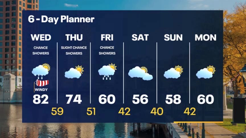
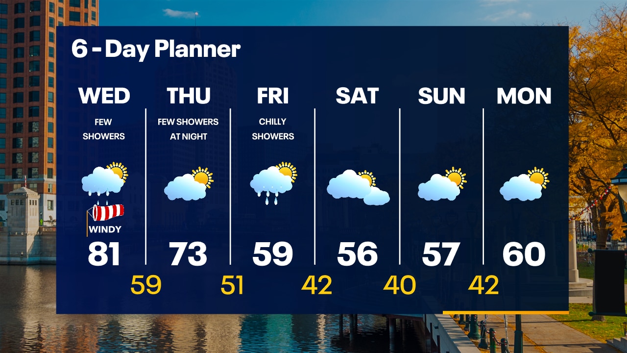
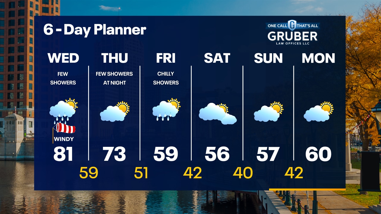
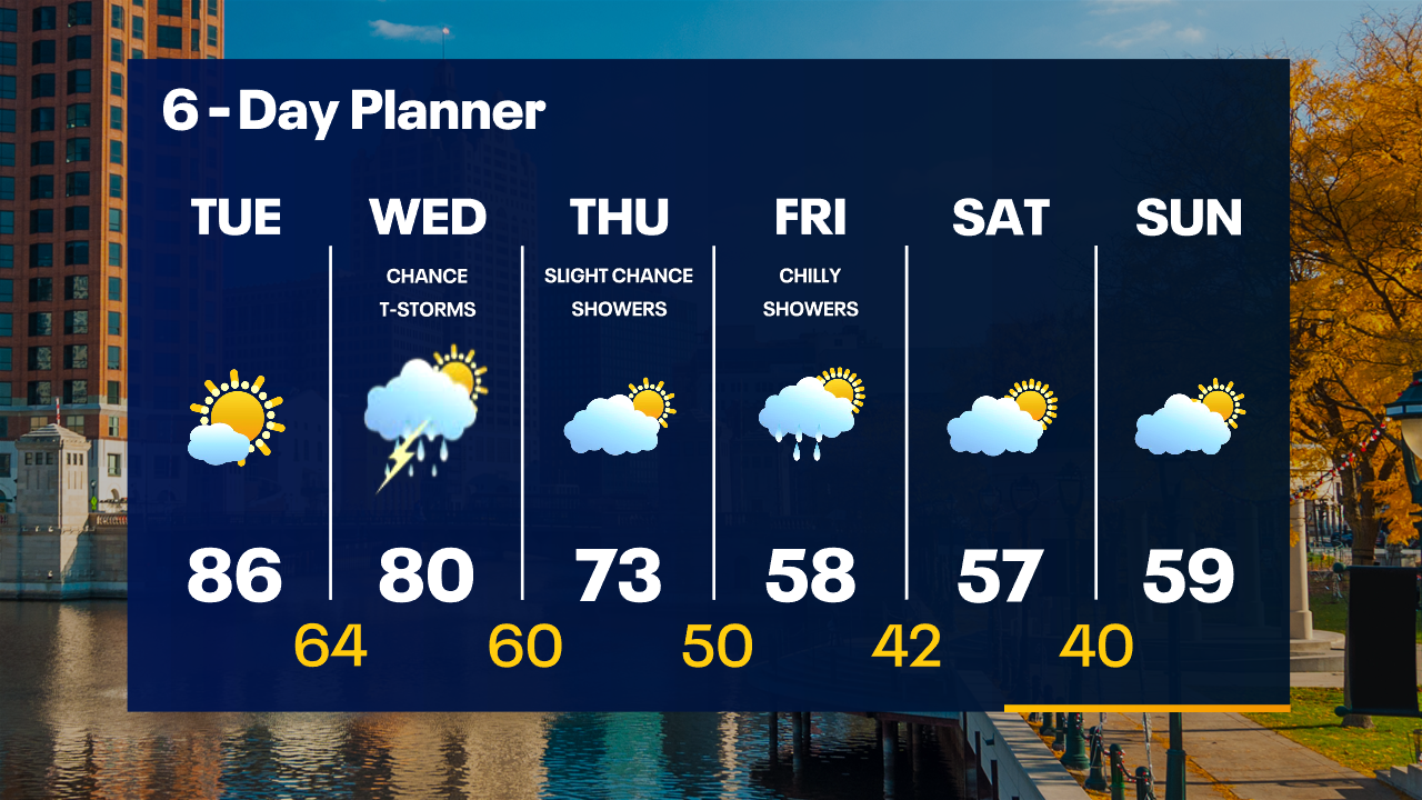
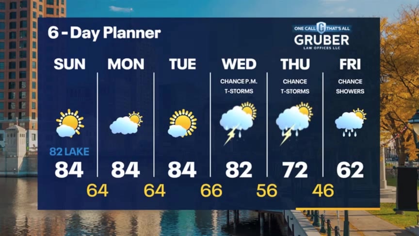
Tracking a cold front today that should clear our area by later this evening. Ahead of this front, we will warm to the low 80s with increasingly cloudy conditions and a chance for showers. There is a slight chance for thunderstorms. There is a chance for showers Thursday and again Friday. We get windy this weekend. Another cold front clears our area later Thursday further dropping temperatures, with highs falling into the upper 50s and low 60s through the weekend.
Tracking a cold front today that should clear our area by later this evening. Ahead of this front, we will warm to the low 80s with increasingly cloudy conditions and a chance for showers. There is a slight chance for thunderstorms. There is a chance for showers Thursday and again Friday. We get windy this weekend. Another cold front clears our area later Thursday further dropping temperatures, with highs falling into the upper 50s and low 60s through the weekend.
Weather Webcast with Tom Wachs
Increasing clouds overnight with temperatures in the 60s. Mostly cloudy with spotty rain showers on Wednesday. It will be windy, warm and humid with a high in the low 80s.
Increasing clouds overnight with temperatures in the 60s. Mostly cloudy with spotty rain showers on Wednesday. It will be windy, warm and humid with a high in the low 80s.
Weather Webcast with Tom Wachs
Increasing clouds tonight with temperatures dropping into the 60s. Mostly cloudy, windy, warm and humid on Wednesday. Highs in the low 80s. A few rain showers are possible during the day Wednesday.
Increasing clouds tonight with temperatures dropping into the 60s. Mostly cloudy, windy, warm and humid on Wednesday. Highs in the low 80s. A few rain showers are possible during the day Wednesday.

Weather Webcast with Stephanie Barichello
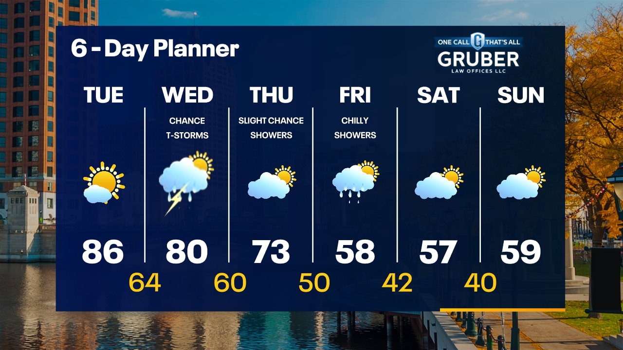
More sunshine and warmth today. We're flirting with the record high of 86?. A chance for afternoon showers or storms Wednesday then chilly rain showers on Friday. Only 50s heading into the weekend!
More sunshine and warmth today. We're flirting with the record high of 86?. A chance for afternoon showers or storms Wednesday then chilly rain showers on Friday. Only 50s heading into the weekend!
Weather webcast with Rob Haswell
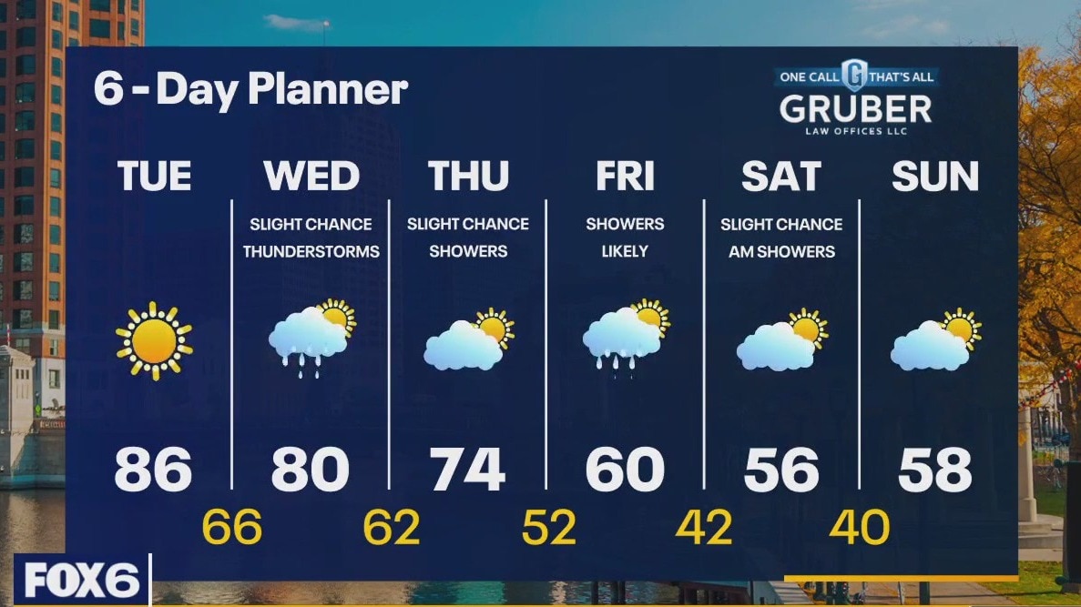
A strong area of high pressure to our east continues to control our forecast keeping us clear and warm. After some patchy morning fog, we will see sunny conditions with highs warming into the mid 80s today. An approaching cold front brings a chance for rain and thunderstorms tomorrow, but we stay ahead of the front long enough to once again reach the 80s. After the front passes, we cool to the 70s Thursday and continue to cool into the 50s by the weekend.
A strong area of high pressure to our east continues to control our forecast keeping us clear and warm. After some patchy morning fog, we will see sunny conditions with highs warming into the mid 80s today. An approaching cold front brings a chance for rain and thunderstorms tomorrow, but we stay ahead of the front long enough to once again reach the 80s. After the front passes, we cool to the 70s Thursday and continue to cool into the 50s by the weekend.
Weather Webcast with Tom Wachs
Clear skies overnight with temperatures in the 60s. Mostly sunny, warm and humid on Tuesday with a near-record high around 86.
Clear skies overnight with temperatures in the 60s. Mostly sunny, warm and humid on Tuesday with a near-record high around 86.
Weather Webcast with Tom Wachs
Clear skies tonight with temperatures dropping into the 60s. Mostly sunny, warm and humid on Tuesday with a record-tying high of 86.
Clear skies tonight with temperatures dropping into the 60s. Mostly sunny, warm and humid on Tuesday with a record-tying high of 86.

Weather Webcast with Stephanie Barichello
A couple more warm days then a drastic drop in temperatures by Friday.
A couple more warm days then a drastic drop in temperatures by Friday.

Weather webcast with Lisa Michaels
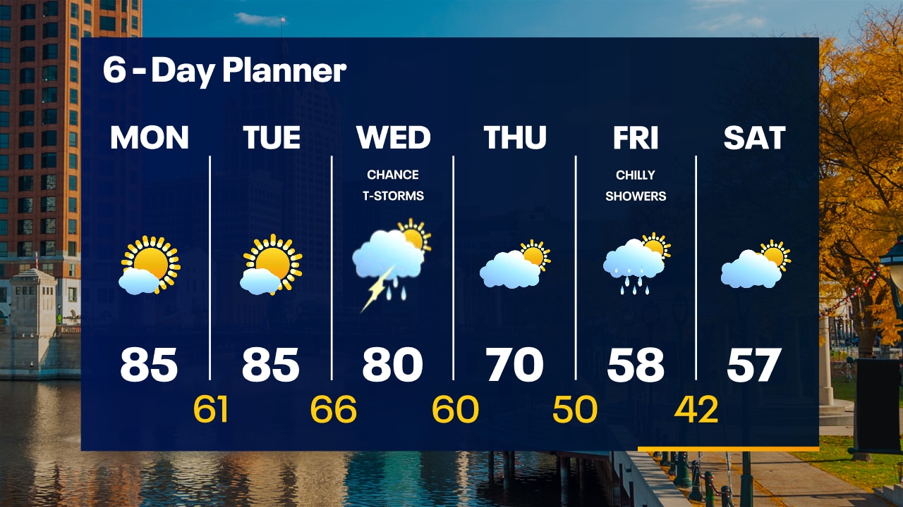
Mostly clear skies with isolated fog Monday morning. Temps in the 50s and low 60s. Mostly sunny, warm and humid again on Monday as high pressure continues to dominate our weather. Highs in the mid-80s. More of the same on Tuesday with highs in the mid-80s. Scattered t-storm chances return on Wednesday with a high around 80. Cooling into the 70s on Thursday behind a cold front, but the big push of chilly air arrives Friday and Saturday with highs in the 50s.
Mostly clear skies with isolated fog Monday morning. Temps in the 50s and low 60s. Mostly sunny, warm and humid again on Monday as high pressure continues to dominate our weather. Highs in the mid-80s. More of the same on Tuesday with highs in the mid-80s. Scattered t-storm chances return on Wednesday with a high around 80. Cooling into the 70s on Thursday behind a cold front, but the big push of chilly air arrives Friday and Saturday with highs in the 50s.
Weather Webcast with Tom Wachs
Patchy fog overnight with temperatures in the 60s. Mostly sunny, warm and humid again on Monday with highs in the mid-80s.
Patchy fog overnight with temperatures in the 60s. Mostly sunny, warm and humid again on Monday with highs in the mid-80s.

Weather Webcast with Tom Wachs
Clear skies tonight with temperatures falling into the 60s. Another sunny, warm and humid day on Monday with highs in the 80s.
Clear skies tonight with temperatures falling into the 60s. Another sunny, warm and humid day on Monday with highs in the 80s.
Weather Webcast with Stephanie Barichello
Another sunny and unseasonably warm day ahead to ring in October! 80s expected through mid-week then rain showers will drop us back to 60s by Friday.
Another sunny and unseasonably warm day ahead to ring in October! 80s expected through mid-week then rain showers will drop us back to 60s by Friday.