


Weather webcast with Lisa Michaels
Partly sunny Saturday with high temps in the upper 20s to low 30s. Wind chills remain in the teens. Winds increasing out of the southwest that could be breezy near the lake.
Partly sunny Saturday with high temps in the upper 20s to low 30s. Wind chills remain in the teens. Winds increasing out of the southwest that could be breezy near the lake.

Webcast Weather with Holly Baker
Warmer temperatures are on the way.
Warmer temperatures are on the way.

Weather webcast with Lisa Michaels
Morning wind chills -5 to 5 at times. Sunny Friday with high temps in the mid to upper 20s. Dry & warming into the 30s by the weekend with upper 30s by Sunday.
Morning wind chills -5 to 5 at times. Sunny Friday with high temps in the mid to upper 20s. Dry & warming into the 30s by the weekend with upper 30s by Sunday.

Weather Webcast with Chief Meteorologist Tom Wachs
Clear and cold overnight with wind chills between 0 and -5 by morning. Abundant sunshine on Friday with highs in the upper 20s. Getting even warmer this weekend with highs in the 30s.
Clear and cold overnight with wind chills between 0 and -5 by morning. Abundant sunshine on Friday with highs in the upper 20s. Getting even warmer this weekend with highs in the 30s.
Weather Webcast with Chief Meteorologist Tom Wachs
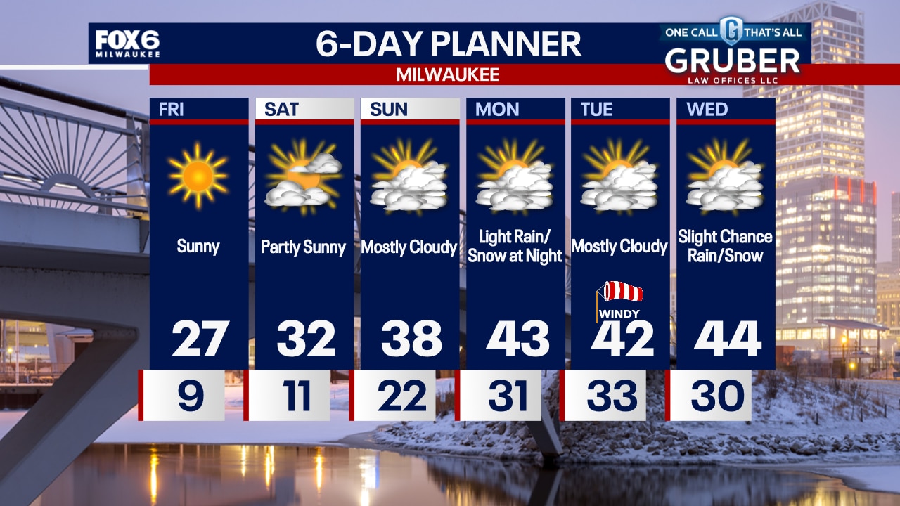
Clear and cold tonight with wind chills around 0 to -5 by morning. Abundant sunshine on Friday with highs in the mid-to-upper 20s. Getting even warmer this weekend.
Clear and cold tonight with wind chills around 0 to -5 by morning. Abundant sunshine on Friday with highs in the mid-to-upper 20s. Getting even warmer this weekend.

Weather webcast with Holly Baker
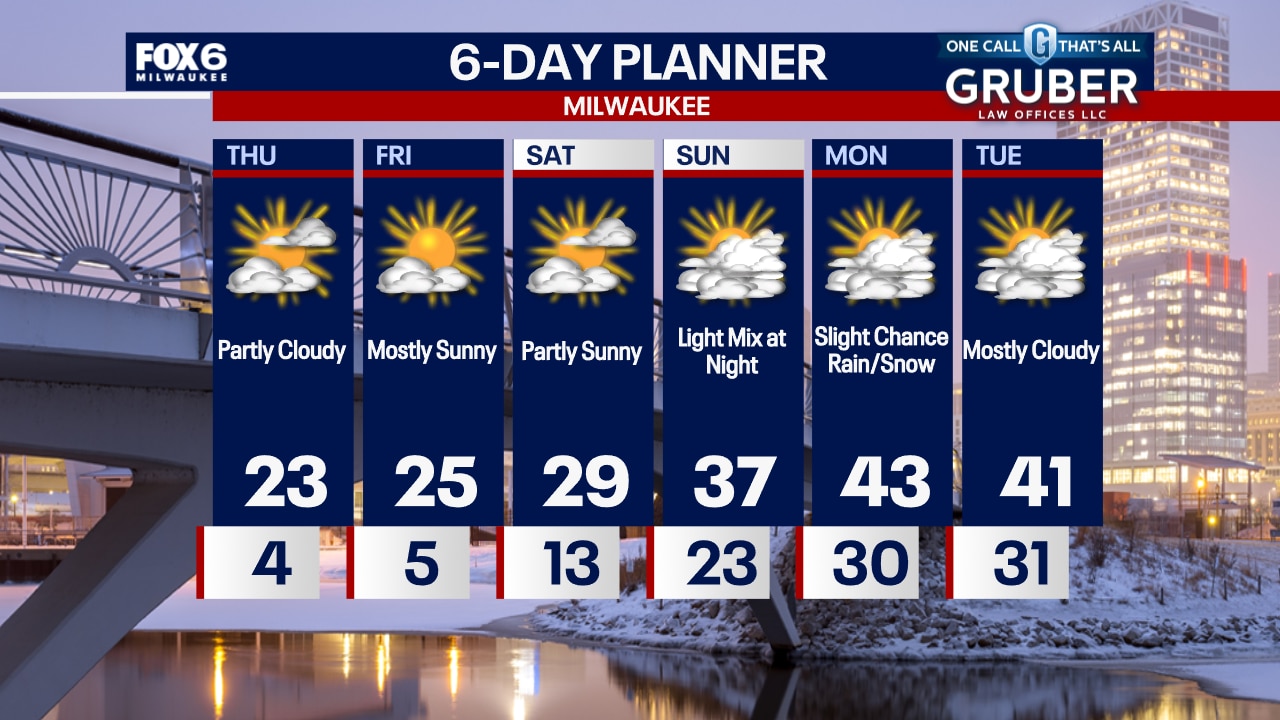
Skies will be partly sunny today. Wind chill values still could be low in the single digits. Mostly sunny with temperatures slightly warmer for Friday.
Skies will be partly sunny today. Wind chill values still could be low in the single digits. Mostly sunny with temperatures slightly warmer for Friday.
Weather Webcast with Chief Meteorologist Tom Wachs
Cold again tonight with wind chills between 0 and -15. Becoming partly cloudy on Thursday with a blustery high in the low 20s and afternoon wind chills in the single digits to low teens.
Cold again tonight with wind chills between 0 and -15. Becoming partly cloudy on Thursday with a blustery high in the low 20s and afternoon wind chills in the single digits to low teens.
Weather webcast with Lisa Michaels
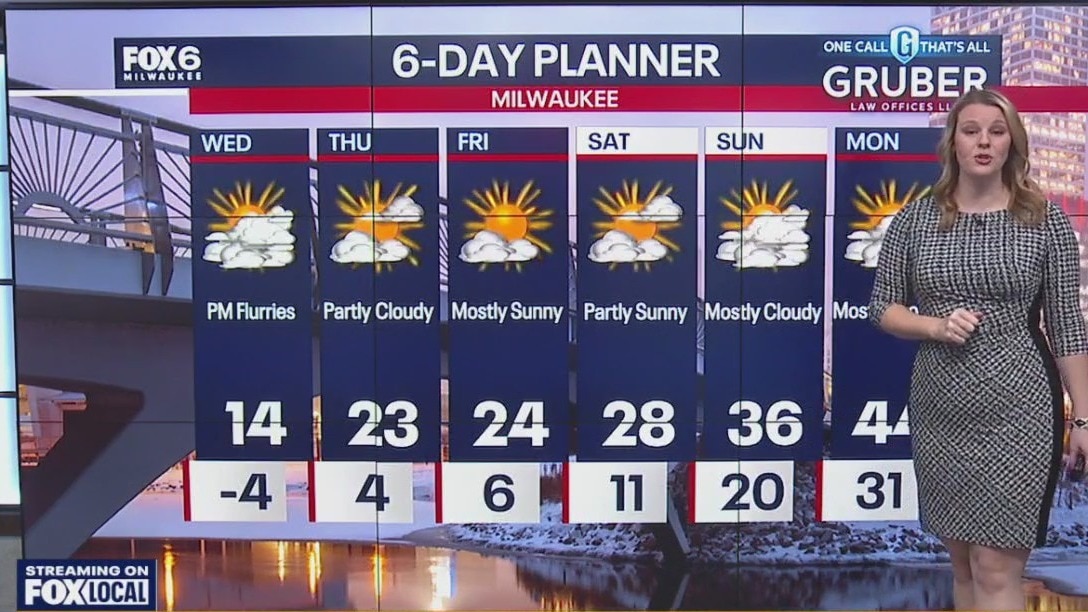
Increasing clouds & cold again tonight. Wind chills dropping as low as -20°F near the lake by morning, -28°F inland.
Increasing clouds & cold again tonight. Wind chills dropping as low as -20°F near the lake by morning, -28°F inland.

Weather webcast with Lisa Michaels
Increasing clouds & cold again tonight. Wind chills dropping as low as -20?F near the lake by morning, -28?F inland.
Increasing clouds & cold again tonight. Wind chills dropping as low as -20?F near the lake by morning, -28?F inland.

Weather webcast with Lisa Michaels
Increasing clouds & cold again tonight. Wind chills dropping as low as -20 near the lake by morning, -28 inland.
Increasing clouds & cold again tonight. Wind chills dropping as low as -20 near the lake by morning, -28 inland.
Weather Webcast with Chief Meteorologist Tom Wachs
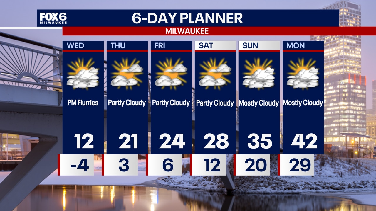
A Cold Weather Advisory is in effect until 10am Wednesday. AM wind chills -20 to -28. Another bitterly cold day on Wednesday with a slow climb out of this through the end of the week.
A Cold Weather Advisory is in effect until 10am Wednesday. AM wind chills -20 to -28. Another bitterly cold day on Wednesday with a slow climb out of this through the end of the week.

Weather webcast with Chief Meteorologist Rob Haswell
A Cold Weather Advisory is in effect until Noon Tuesday. Morning lows will be sub-zero and feel colder than -20 at times. Highs will reach 10 degrees with ample sun.
A Cold Weather Advisory is in effect until Noon Tuesday. Morning lows will be sub-zero and feel colder than -20 at times. Highs will reach 10 degrees with ample sun.

Weather webcast with Lisa Michaels
Mostly clear skies tonight with temps dropping below zero. A Cold Weather Advisory is in effect from 9PM Monday until Tuesday 12PM. Wind chills will be 20 to 29 below zero. We will be dry majority of the week. However, there is a slight chance for flurries on Wednesday night. A slight warm up arrives by the end of the week with highs back in the mid 20s and 30s by the weekend.
Mostly clear skies tonight with temps dropping below zero. A Cold Weather Advisory is in effect from 9PM Monday until Tuesday 12PM. Wind chills will be 20 to 29 below zero. We will be dry majority of the week. However, there is a slight chance for flurries on Wednesday night. A slight warm up arrives by the end of the week with highs back in the mid 20s and 30s by the weekend.

Weather webcast with Rob Haswell
A bitterly cold stretch begins Monday and continues through most of the week. A Cold Weather Advisory is in place today with another set for tomorrow. Wind chills at times will be 20 to 25 below zero.
A bitterly cold stretch begins Monday and continues through most of the week. A Cold Weather Advisory is in place today with another set for tomorrow. Wind chills at times will be 20 to 25 below zero.

Weather Webcast with Holly Baker
A cold weather advisory will be in effect at midnight until 11am Monday.
A cold weather advisory will be in effect at midnight until 11am Monday.

Weather webcast with Lisa Michaels
Lingering light snow showers for the first half of Sunday. A trace up to half an inch of new accumulation is possible. Colder temperatures swing into Wisconsin Sunday with highs in the mid 20s early then falling into the low 20s by the afternoon.
Lingering light snow showers for the first half of Sunday. A trace up to half an inch of new accumulation is possible. Colder temperatures swing into Wisconsin Sunday with highs in the mid 20s early then falling into the low 20s by the afternoon.

Weather Webcast with Holly Baker
Light snow lingers for another day.
Light snow lingers for another day.

Weather webcast with Lisa Michaels
A Winter Weather Advisory has been extended through 6 p.m. Saturday. Additional snow can accumulate 1-3" with isolated 4" if a heavier band sets up near the lake. Lingering light snow showers possible on Sunday which could bring minor accumulations less than 1".
A Winter Weather Advisory has been extended through 6 p.m. Saturday. Additional snow can accumulate 1-3" with isolated 4" if a heavier band sets up near the lake. Lingering light snow showers possible on Sunday which could bring minor accumulations less than 1".

Weather Webcast with Holly Baker
Tracking more snow in the area.
Tracking more snow in the area.

Weather webcast with Lisa Michaels
A Winter Weather Advisory is in effect from 6pm Friday until 6am on Saturday. Snow could accumulate 3-5" tonight. More accumulating snowfall on Saturday and Sunday. Winter weather headlines could be extended into the weekend. Highs in the low 30s on Saturday and getting colder in the mid 20s on Sunday. Much colder air arrives for early next week with sub-zero lows and highs in the single digits. Cold weather headlines could be issued Sunday night into early next week with wind chills double digits below zero.
A Winter Weather Advisory is in effect from 6pm Friday until 6am on Saturday. Snow could accumulate 3-5" tonight. More accumulating snowfall on Saturday and Sunday. Winter weather headlines could be extended into the weekend. Highs in the low 30s on Saturday and getting colder in the mid 20s on Sunday. Much colder air arrives for early next week with sub-zero lows and highs in the single digits. Cold weather headlines could be issued Sunday night into early next week with wind chills double digits below zero.