


Weather Webcast with Chief Meteorologist Tom Wachs
Clearing skies overnight. Temperatures dropping into the single digits inland, low teens near the lake. Partly sunny and cold on Thursday with highs in the low 20s. Light snow is possible after 8pm Thursday night.
Clearing skies overnight. Temperatures dropping into the single digits inland, low teens near the lake. Partly sunny and cold on Thursday with highs in the low 20s. Light snow is possible after 8pm Thursday night.

Weather Webcast with Chief Meteorologist Tom Wachs
Cold tonight with temperatures dropping into the single digits to around 10 by morning. Increasing clouds and chilly on Thursday with highs in the low 20s. Snow is possible on Thursday night.
Cold tonight with temperatures dropping into the single digits to around 10 by morning. Increasing clouds and chilly on Thursday with highs in the low 20s. Snow is possible on Thursday night.

Wisconsin Weather Experts | December 10, 2025
Wisconsin's Weather Experts have the latest statewide forecast, extended outlook and more.
Wisconsin's Weather Experts have the latest statewide forecast, extended outlook and more.

Weather webcast with Lisa Michaels
Light snow and pockets of freezing drizzle move through southern Wisconsin Wednesday morning, tapering off by late morning as colder air and gusty north winds settle in.
Light snow and pockets of freezing drizzle move through southern Wisconsin Wednesday morning, tapering off by late morning as colder air and gusty north winds settle in.
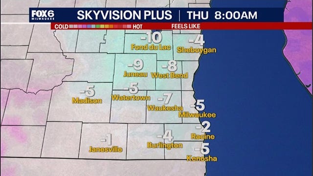

Dangerous cold returns to Wisconsin: –15° to –30° wind chills possible
Wisconsin is heading into one of its coldest stretches of the season as a surge of Arctic air arrives late this week.
Wisconsin is heading into one of its coldest stretches of the season as a surge of Arctic air arrives late this week.

Wisconsin snowfall totals: Overnight Tuesday into Wednesday
The National Weather Service collected snowfall data from the winter weather that impacted southeast Wisconsin from Tuesday into Wednesday morning.
The National Weather Service collected snowfall data from the winter weather that impacted southeast Wisconsin from Tuesday into Wednesday morning.

Weather webcast with Rob Haswell
Light snow and pockets of freezing drizzle move through southern Wisconsin this morning, tapering off by late morning as colder air and gusty north winds settle in.
Light snow and pockets of freezing drizzle move through southern Wisconsin this morning, tapering off by late morning as colder air and gusty north winds settle in.

Weather Webcast with Chief Meteorologist Tom Wachs
A wintry mix (snow north) will transition to all snow again overnight. Gusty winds out of the north after 6am means a SLOW AM commute. Snow and wind on Wednesday AM will mean low visibility on the roads along with icy patches with falling temperatures. Please use caution.
A wintry mix (snow north) will transition to all snow again overnight. Gusty winds out of the north after 6am means a SLOW AM commute. Snow and wind on Wednesday AM will mean low visibility on the roads along with icy patches with falling temperatures. Please use caution.


Wisconsin winter weather advisory Tuesday into Wednesday morning
The NWS expanded a winter weather advisory that now impacts most of southeast Wisconsin from Tuesday into Wednesday morning, Dec. 10.
The NWS expanded a winter weather advisory that now impacts most of southeast Wisconsin from Tuesday into Wednesday morning, Dec. 10.


Milwaukee Weather: Snow and rain return to Wisconsin
Winter Weather Advisory until 6am on Wednesday for Ozaukee, Washington, Dodge, Jefferson, Fond du Lac and Sheboygan Co. Any rain that developed will change back to snow overnight. VERY windy after 6am, gusts to 40mph. Snow through 11am Wednesday with low visibility. and icy patches (re-freeze with the colder air). Scattered PM snow showers.
Winter Weather Advisory until 6am on Wednesday for Ozaukee, Washington, Dodge, Jefferson, Fond du Lac and Sheboygan Co. Any rain that developed will change back to snow overnight. VERY windy after 6am, gusts to 40mph. Snow through 11am Wednesday with low visibility. and icy patches (re-freeze with the colder air). Scattered PM snow showers.

Weather Webcast with Chief Meteorologist Tom Wachs
A mix of sleet, freezing rain, rain and snow tonight. Greatest snow accumulation north of Milwaukee, switching to rain in Milwaukee late this evening. Slick spots are possible all night. Everyone changes to snow on Wednesday morning with strong winds as well.
A mix of sleet, freezing rain, rain and snow tonight. Greatest snow accumulation north of Milwaukee, switching to rain in Milwaukee late this evening. Slick spots are possible all night. Everyone changes to snow on Wednesday morning with strong winds as well.

Wisconsin Weather Experts | Dec. 9, 2025
Wisconsin's Weather Experts have the latest statewide forecast, extended outlook and more.
Wisconsin's Weather Experts have the latest statewide forecast, extended outlook and more.

Weather webcast with Stephanie Barichello
Light snow and pockets of freezing drizzle will give way to a stronger storm tonight, bringing 2 to 5 inches of snow and some mixed precipitation into early Wednesday.
Light snow and pockets of freezing drizzle will give way to a stronger storm tonight, bringing 2 to 5 inches of snow and some mixed precipitation into early Wednesday.

Weather webcast with Rob Haswell
Light snow and pockets of freezing drizzle will give way to a stronger storm tonight, bringing 2 to 5 inches of snow and some mixed precipitation into early Wednesday.
Light snow and pockets of freezing drizzle will give way to a stronger storm tonight, bringing 2 to 5 inches of snow and some mixed precipitation into early Wednesday.
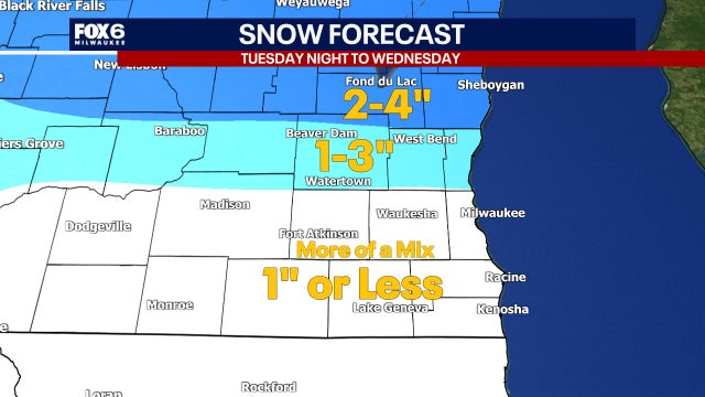

Winter weather advisory for southeast Wisconsin; what you need to know
The National Weather Service has issued a winter weather advisory for the northern half of the FOX6 viewing area from 6 p.m. Tuesday, Dec. 9 through 6 a.m. Wednesday, Dec. 10.
The National Weather Service has issued a winter weather advisory for the northern half of the FOX6 viewing area from 6 p.m. Tuesday, Dec. 9 through 6 a.m. Wednesday, Dec. 10.
Milwaukee Weather - Snow overnight with another storm Tuesday night
Winter Weather Advisory 6pm Tuesday to 6am Wednesday for Ozaukee, Washington, Dodge, Fond du Lac and Sheboygan Co. Cloudy and blustery tonight with snow between 12am-5am. 0.5"-1.0" possible, a little higher north and lower toward the IL border. Morning freezing drizzle is possible on Tuesday, otherwise cloudy and blustery. Highs in the mid-30s.
Winter Weather Advisory 6pm Tuesday to 6am Wednesday for Ozaukee, Washington, Dodge, Fond du Lac and Sheboygan Co. Cloudy and blustery tonight with snow between 12am-5am. 0.5"-1.0" possible, a little higher north and lower toward the IL border. Morning freezing drizzle is possible on Tuesday, otherwise cloudy and blustery. Highs in the mid-30s.
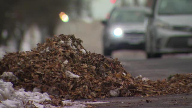

Snow preventing Milwaukee DPW from clearing leaves, residents frustrated
Frozen, snow-covered leaves are piling up on Milwaukee streets, and many residents are getting frustrated.
Frozen, snow-covered leaves are piling up on Milwaukee streets, and many residents are getting frustrated.

Weather Webcast with Chief Meteorologist Tom Wachs
Light snow through 5am, generally less than 0.5" expected. Some freezing drizzle is possible in the morning, otherwise dry on Tuesday. A wintry mix moves in after 6-7pm with rain/sleet/snow possible on Tuesday night.
Light snow through 5am, generally less than 0.5" expected. Some freezing drizzle is possible in the morning, otherwise dry on Tuesday. A wintry mix moves in after 6-7pm with rain/sleet/snow possible on Tuesday night.

Snowy leaf piles frustrating for Milwaukee residents
Right now frozen, snow-covered leaves are piling up on Milwaukee streets, and many residents are getting frustrated.
Right now frozen, snow-covered leaves are piling up on Milwaukee streets, and many residents are getting frustrated.

Weather Webcast with Chief Meteorologist Tom Wachs
Snow between 12am-5am on Tuesday. 0.5"-1.0" of snow possible. Storm system #2 will be stronger on Tuesday night and Wednesday morning with a wintry mix likely.
Snow between 12am-5am on Tuesday. 0.5"-1.0" of snow possible. Storm system #2 will be stronger on Tuesday night and Wednesday morning with a wintry mix likely.