

Weather Webcast with Meteorologist Stephanie Barichello
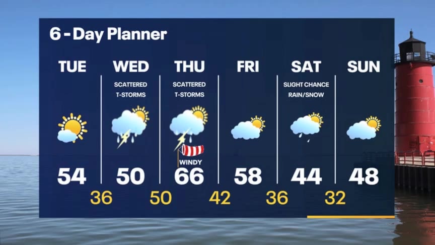
Sunny and quiet today then expect a few rounds of thunderstorms Wednesday into Thursday. Cooling back into the 40s this weekend.
Sunny and quiet today then expect a few rounds of thunderstorms Wednesday into Thursday. Cooling back into the 40s this weekend.

Lyrid meteor shower: When it peaks and how to watch it
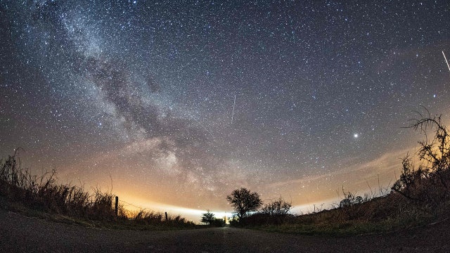
NASA says the Lyrids are one of the oldest known meteor showers
NASA says the Lyrids are one of the oldest known meteor showers
Weather webcast with Rob Haswell
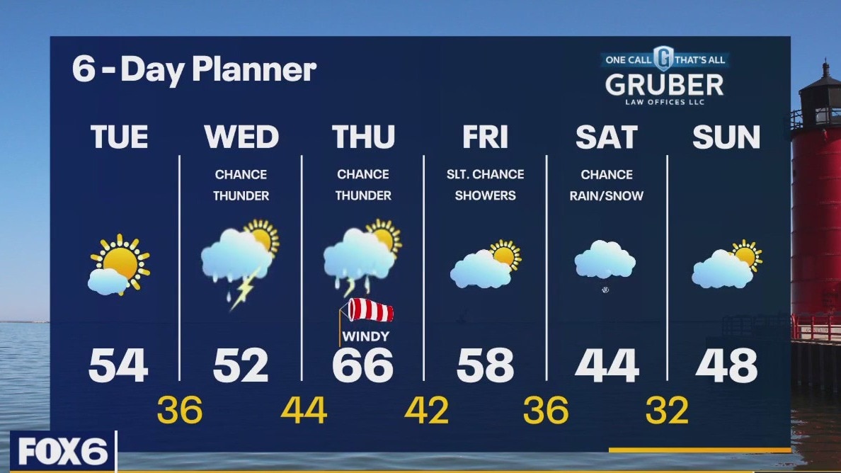
High pressure builds across the area today bringing sun and seasonal temperatures. Highs will reach the low to mid 50s. A low and its warm front approach on Wednesday with increasingly cloudy conditions and a chance for rain and thunderstorms. As the love moves through Thursday we can again expect rain and thunderstorms with warmer temperatures. We calm down Friday and should cool down again this weekend.
High pressure builds across the area today bringing sun and seasonal temperatures. Highs will reach the low to mid 50s. A low and its warm front approach on Wednesday with increasingly cloudy conditions and a chance for rain and thunderstorms. As the love moves through Thursday we can again expect rain and thunderstorms with warmer temperatures. We calm down Friday and should cool down again this weekend.
Weather Webcast with Meteorologist Eric Manges
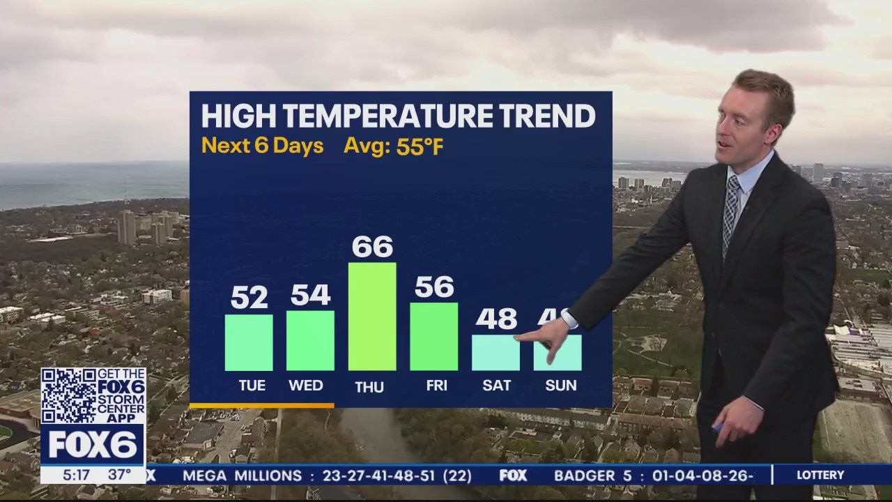
Today was a harsh reminder of the weather mid-April can bring and we don't get much better anytime soon.
Today was a harsh reminder of the weather mid-April can bring and we don't get much better anytime soon.
Weather Webcast with Meteorologist Stephanie Barichello
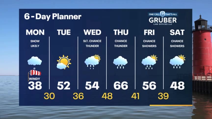
Light snow possible at times this afternoon then sunshine returns on Tuesday. A fairly active forecast going forward with rain chances from Wednesday through the weekend. Temperatures will mainly stay in the 50s.
Light snow possible at times this afternoon then sunshine returns on Tuesday. A fairly active forecast going forward with rain chances from Wednesday through the weekend. Temperatures will mainly stay in the 50s.
Weather webcast with Rob Haswell
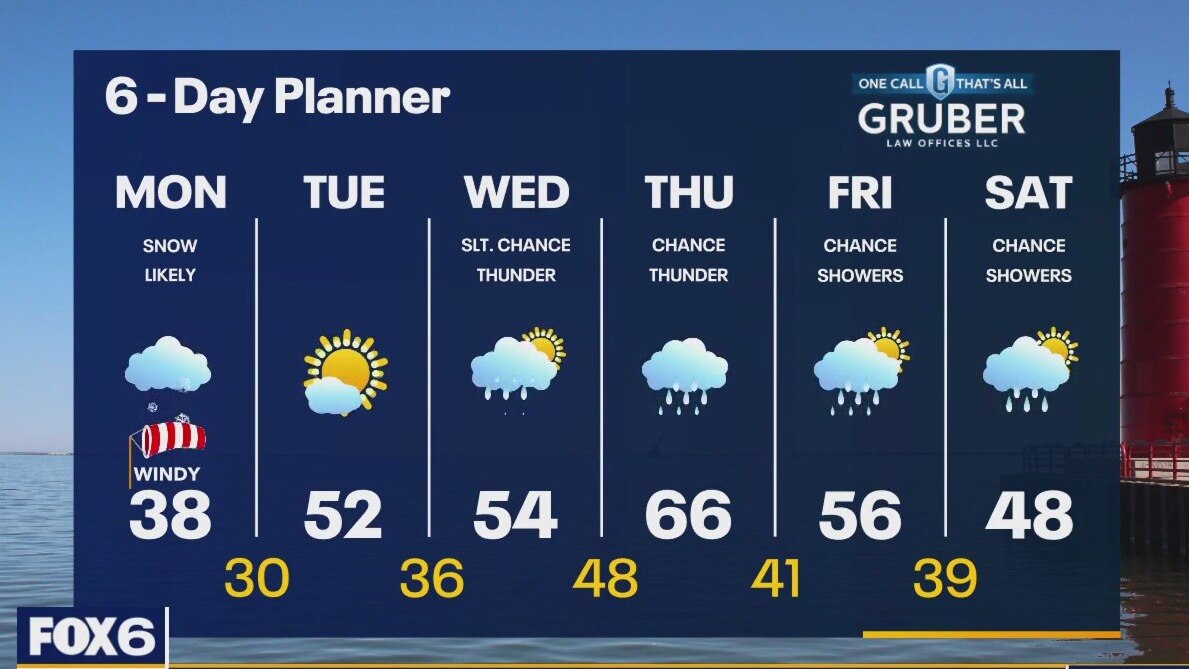
A surface low slowly moves across WI and east into MI today. Much colder air on the backside of this low is producing snow. A light snow is likely this morning tapering to snow showers this afternoon. Light accumulations are possible in our area with heavier snowfall to our west. We clear overnight and get back to sun by Tuesday. Highs will go from the upper 30s today to the low 50s tomorrow melting any snow that remains. A warm front arrives later this week causing rain and thunderstorms and pushing temperatures into the 60s.
A surface low slowly moves across WI and east into MI today. Much colder air on the backside of this low is producing snow. A light snow is likely this morning tapering to snow showers this afternoon. Light accumulations are possible in our area with heavier snowfall to our west. We clear overnight and get back to sun by Tuesday. Highs will go from the upper 30s today to the low 50s tomorrow melting any snow that remains. A warm front arrives later this week causing rain and thunderstorms and pushing temperatures into the 60s.
Weather Webcast with Tom Wachs
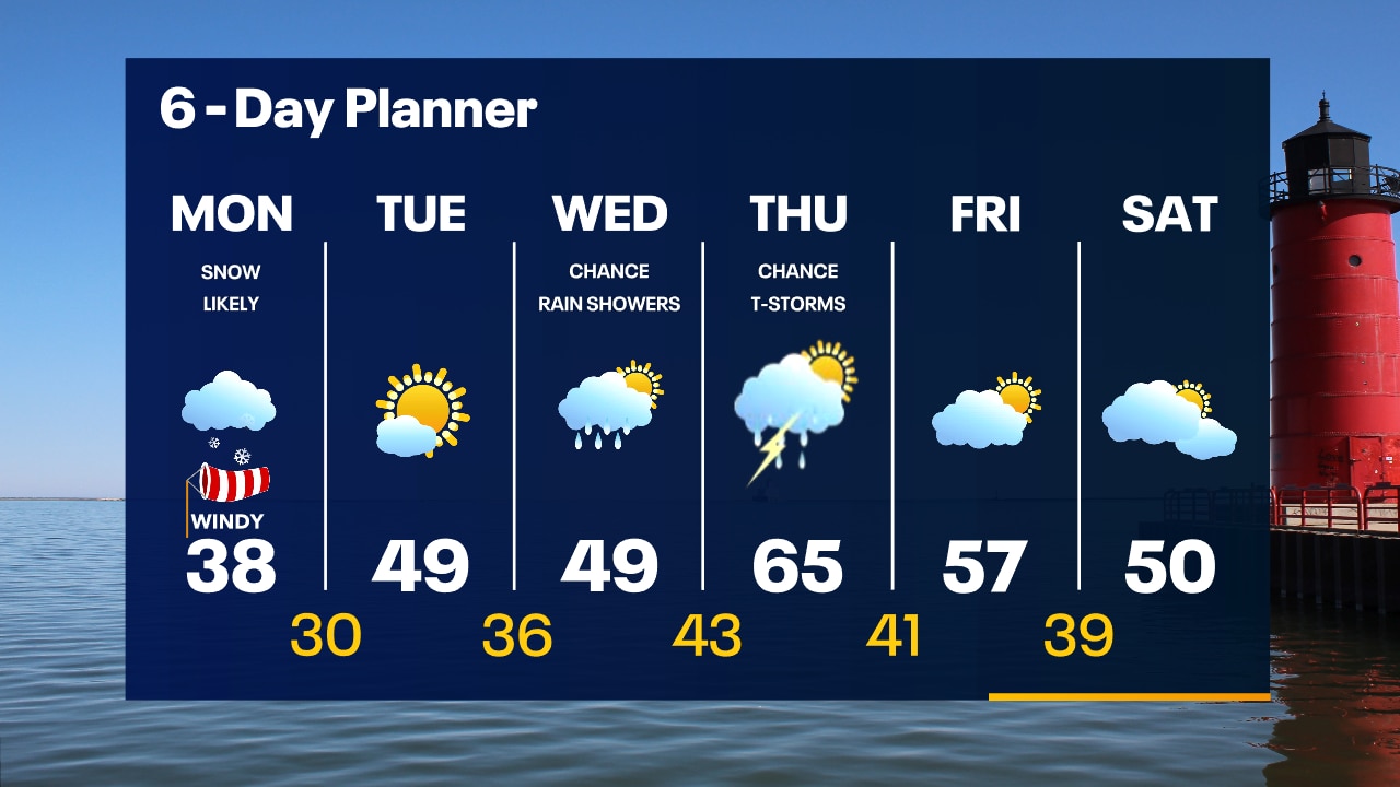
Snowy and windy overnight. Temperatures in the upper 20s to low 30s. Snowy for the morning commute Monday. Most of the snow will be on the grass. 1" or less Milwaukee.
Snowy and windy overnight. Temperatures in the upper 20s to low 30s. Snowy for the morning commute Monday. Most of the snow will be on the grass. 1" or less Milwaukee.

From 85° to 8.5" of snow...winter storm hits western Wisconsin
From 85° to 8.5" of snow...western Wisconsin was getting walloped by winter weather on Sunday.
From 85° to 8.5" of snow...western Wisconsin was getting walloped by winter weather on Sunday.
Weather Webcast with Tom Wachs
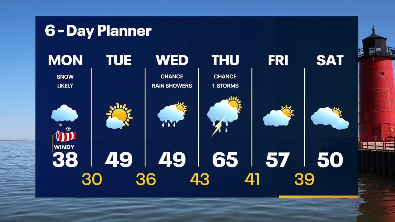
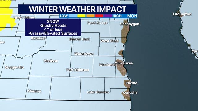
Rain changing to snow tonight. Windy. Temperatures dropping through the 30s. Off-and-on snow showers Monday. Windy and cold. 1" or less Milwaukee, 1-3" farther inland, mainly on the grass.
Rain changing to snow tonight. Windy. Temperatures dropping through the 30s. Off-and-on snow showers Monday. Windy and cold. 1" or less Milwaukee, 1-3" farther inland, mainly on the grass.

Snow hits southeastern Wisconsin in spring
Snow will continue through the morning commute time on Monday. Accumulation will be minimal. Falling temperatures through Sunday. Back in the low 30s tonight. Breezy on Monday with temperatures in the 30s and wind chills in the 20s.
Snow will continue through the morning commute time on Monday. Accumulation will be minimal. Falling temperatures through Sunday. Back in the low 30s tonight. Breezy on Monday with temperatures in the 30s and wind chills in the 20s.


El Niño is making a comeback; What does that mean for hurricane season?
A changing pattern in the Pacific Ocean could cut the number of Atlantic hurricanes in 2023.
A changing pattern in the Pacific Ocean could cut the number of Atlantic hurricanes in 2023.

IRS extends tax deadlines for storm victims in these 7 states
Individuals, households and businesses in disaster areas as designated by FEMA qualify for the tax relief.
Individuals, households and businesses in disaster areas as designated by FEMA qualify for the tax relief.

Weather Webcast with Meteorologist Lisa Michaels
Rain showers continue through the first half of Sunday. A transition to snow will occur this afternoon into the evening. Snow will continue through the morning commute time on Monday. Accumulation will be minimal.
Rain showers continue through the first half of Sunday. A transition to snow will occur this afternoon into the evening. Snow will continue through the morning commute time on Monday. Accumulation will be minimal.
Weather Webcast with Meteorologist Eric Manges
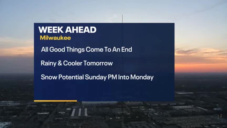
Get ready for a big temperature drop by Monday and even snow chances
Get ready for a big temperature drop by Monday and even snow chances

SE Wisconsin storms, snow possible this weekend
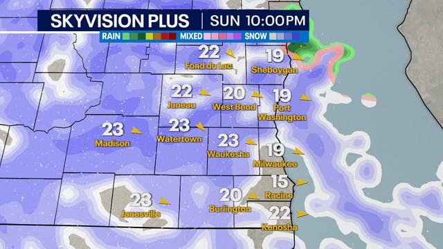
From storms to snow, Wisconsin can see it all within a 48 hour period. Winter-like temperatures and snow will move in behind a low pressure system.
From storms to snow, Wisconsin can see it all within a 48 hour period. Winter-like temperatures and snow will move in behind a low pressure system.

Weather Webcast with Meteorologist Lisa Michaels
Partly cloudy to mostly cloudy today with highs reaching close to 80F. Chances of scattered rain and storms arrive this afternoon and evening. Isolated stronger storms could pose a risk for hail and damaging winds
Partly cloudy to mostly cloudy today with highs reaching close to 80F. Chances of scattered rain and storms arrive this afternoon and evening. Isolated stronger storms could pose a risk for hail and damaging winds


Wisconsin Arcadia wildfire reaches 3K+ acres, Fort McCoy contained
Wisconsin DNR fire crews and local agencies remained on the scene Friday, April 14 of the Arcadia wildfire outside Fort McCoy in western Wisconsin.
Wisconsin DNR fire crews and local agencies remained on the scene Friday, April 14 of the Arcadia wildfire outside Fort McCoy in western Wisconsin.
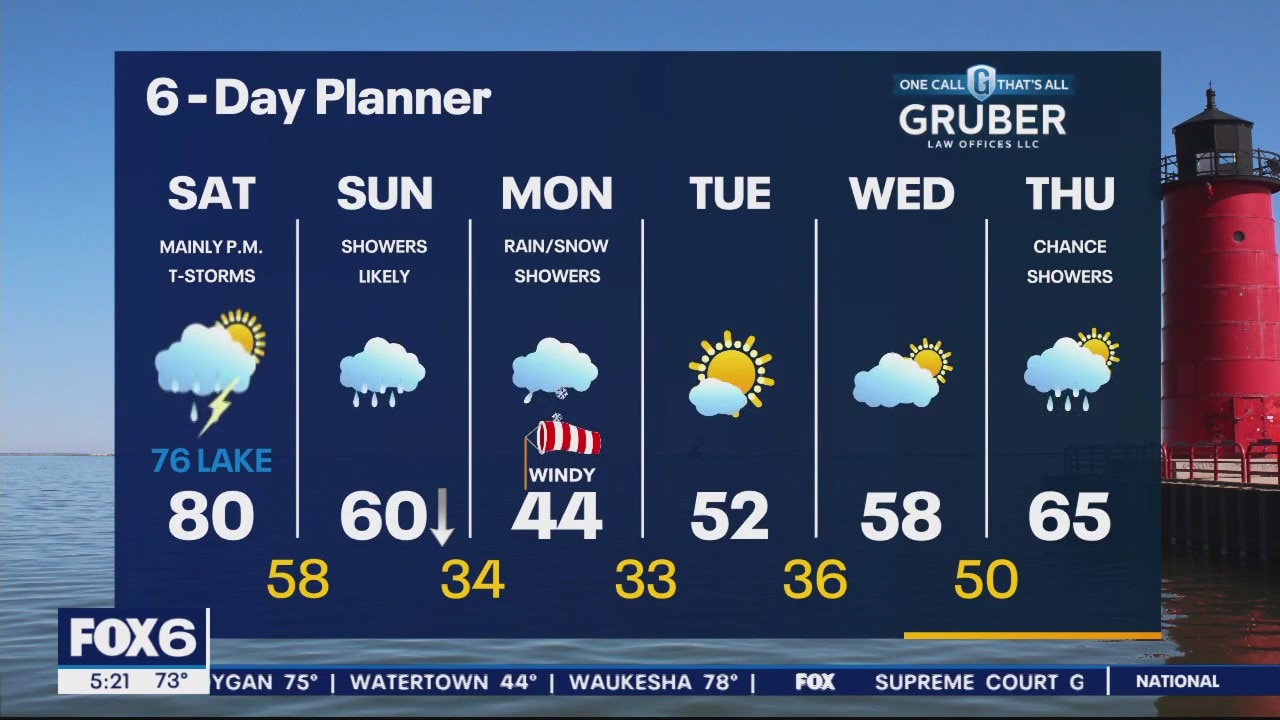
Weather Webcast with Meteorologist Eric Manges
Get ready for a temperature drop Sunday into Monday and even snow chances.
Get ready for a temperature drop Sunday into Monday and even snow chances.
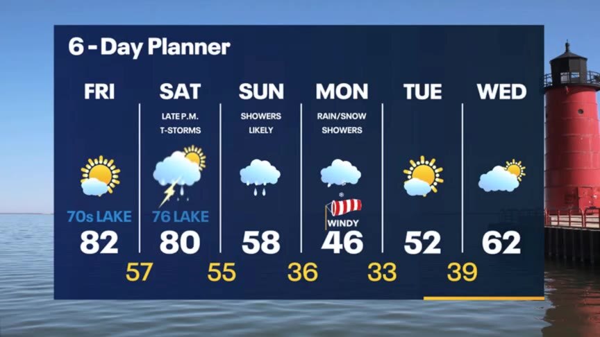
Weather Webcast with Meteorologist Stephanie Barichello
Sunny and pleasant today then a chance for storms Saturday. Rain is more likely on Sunday with slushy snow to start Monday. Warming back into the 60s by the middle of next week.
Sunny and pleasant today then a chance for storms Saturday. Rain is more likely on Sunday with slushy snow to start Monday. Warming back into the 60s by the middle of next week.
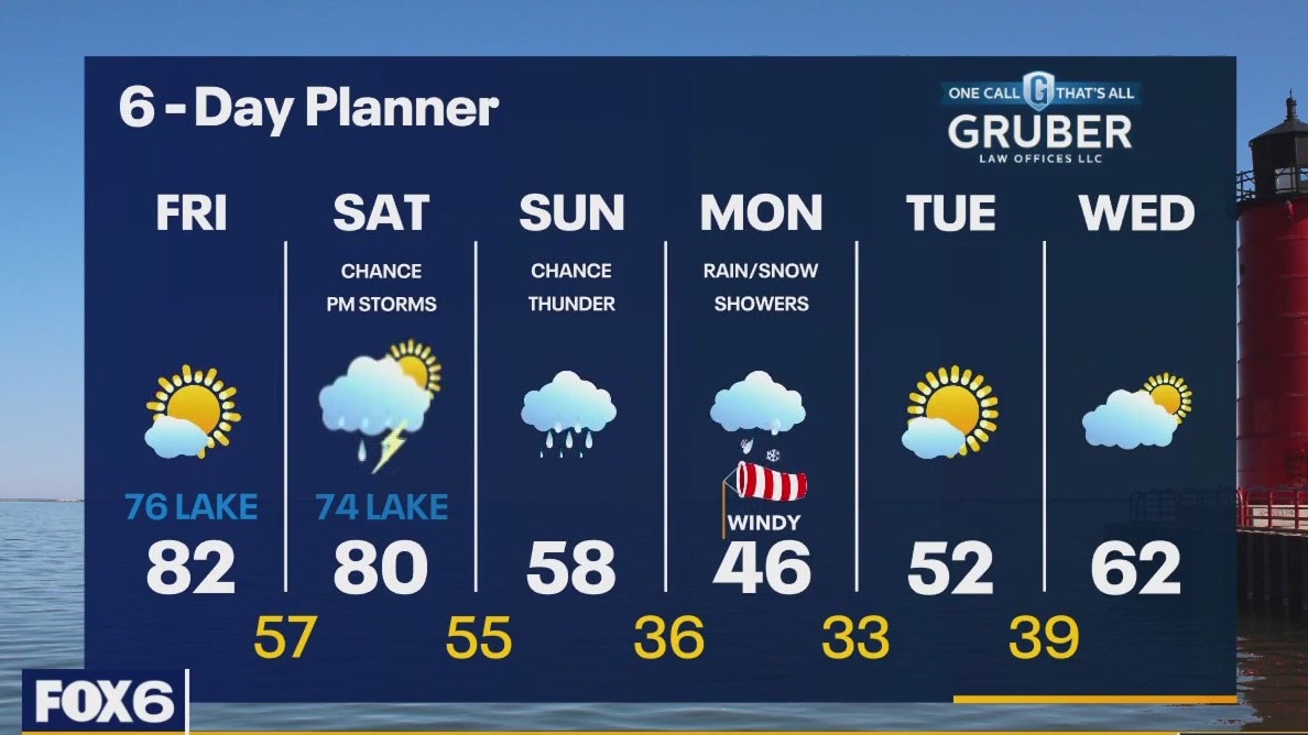
Weather webcast with Rob Haswell
We stay ahead of an advancing cold front today and most of tomorrow keeping temperatures very warm. Highs today will be in the low 80s but with a SE wind, it will be cooler lakeside. Highs on Saturday will reach 80 inland but stay in the low 70s near the lake. By Saturday afternoon we should see some showers with a better chance of rain late Saturday into Sunday. Rain continues Sunday with a chance for thunder. Light rain and snow is possible on Monday as we cool into the 40s. We return to more seasonal weather next week.
We stay ahead of an advancing cold front today and most of tomorrow keeping temperatures very warm. Highs today will be in the low 80s but with a SE wind, it will be cooler lakeside. Highs on Saturday will reach 80 inland but stay in the low 70s near the lake. By Saturday afternoon we should see some showers with a better chance of rain late Saturday into Sunday. Rain continues Sunday with a chance for thunder. Light rain and snow is possible on Monday as we cool into the 40s. We return to more seasonal weather next week.