

Weather Webcast with Chief Meteorologist Tom Wachs
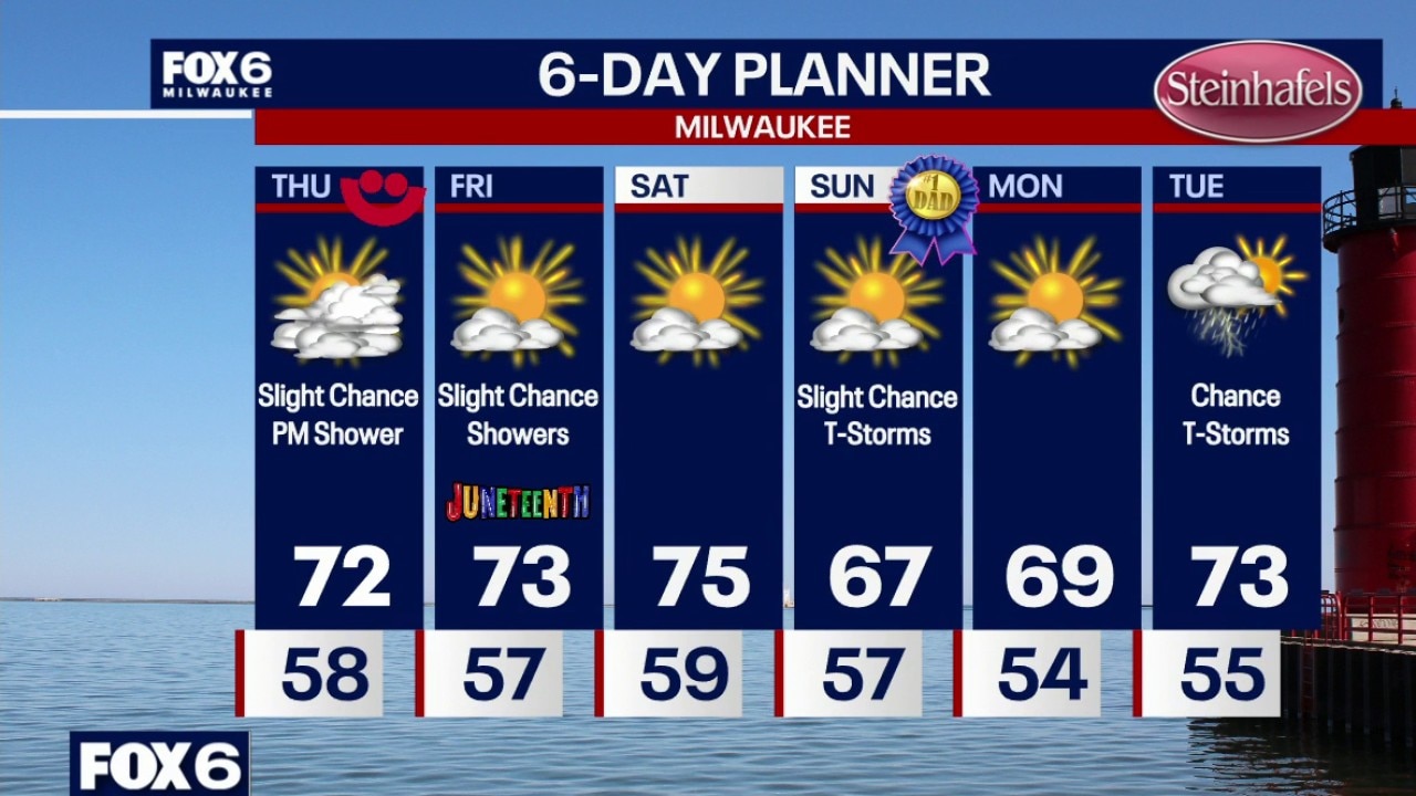
Storms have moved out. An isolated t-storm is possible otherwise partly to mostly cloudy overnight with temperatures in the 50s. Mostly cloudy and breezy on Thursday with a slight chance for a late day or evening rain shower. Highs in the low 70s. Partly sunny on Friday with a slight chance for a rain shower. Highs in the low-to-mid 70s.
Storms have moved out. An isolated t-storm is possible otherwise partly to mostly cloudy overnight with temperatures in the 50s. Mostly cloudy and breezy on Thursday with a slight chance for a late day or evening rain shower. Highs in the low 70s. Partly sunny on Friday with a slight chance for a rain shower. Highs in the low-to-mid 70s.


Milwaukee Weather: Scattered storms tonight, warmer on Thursday
Storms have moved out. An isolated t-storm is possible otherwise partly to mostly cloudy overnight with temperatures in the 50s. Mostly cloudy and breezy on Thursday with a slight chance for a late day or evening rain shower. Highs in the low 70s. Partly sunny on Friday with a slight chance for a rain shower. Highs in the low-to-mid 70s.
Storms have moved out. An isolated t-storm is possible otherwise partly to mostly cloudy overnight with temperatures in the 50s. Mostly cloudy and breezy on Thursday with a slight chance for a late day or evening rain shower. Highs in the low 70s. Partly sunny on Friday with a slight chance for a rain shower. Highs in the low-to-mid 70s.


Wisconsin severe weather warnings, watches issued Wednesday evening
The FOX6 Weather Experts are tracking severe weather, including tornado and thunderstorm warnings, across southeast Wisconsin on Wednesday evening, June 17.
The FOX6 Weather Experts are tracking severe weather, including tornado and thunderstorm warnings, across southeast Wisconsin on Wednesday evening, June 17.
Weather Webcast with Chief Meteorologist Tom Wachs
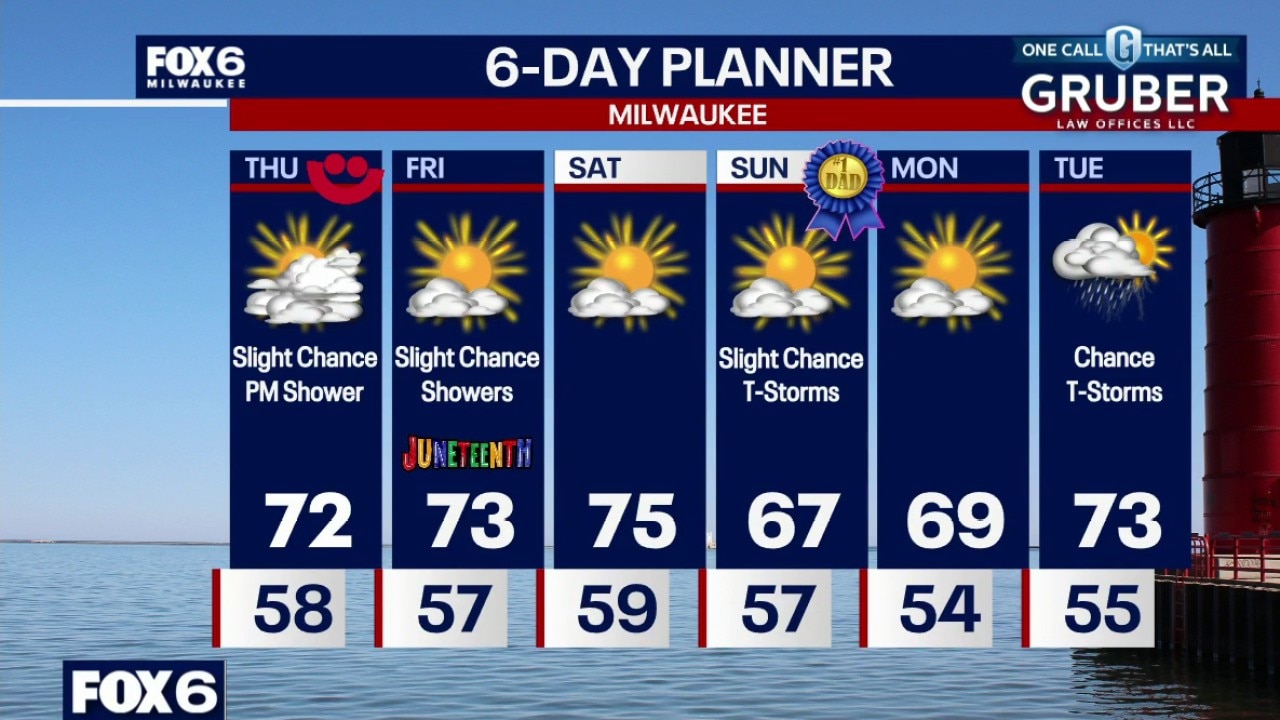
Scattered t-storms this evening, gusty winds, hail and heavy rain possible. Temperatures will remain chilly, in the 50s all night. Mostly cloudy and breezy on Thursday with a slight chance for a late day or evening rain shower. Highs in the low 70s.
Scattered t-storms this evening, gusty winds, hail and heavy rain possible. Temperatures will remain chilly, in the 50s all night. Mostly cloudy and breezy on Thursday with a slight chance for a late day or evening rain shower. Highs in the low 70s.
Weather Webcast with Stephanie Barichello
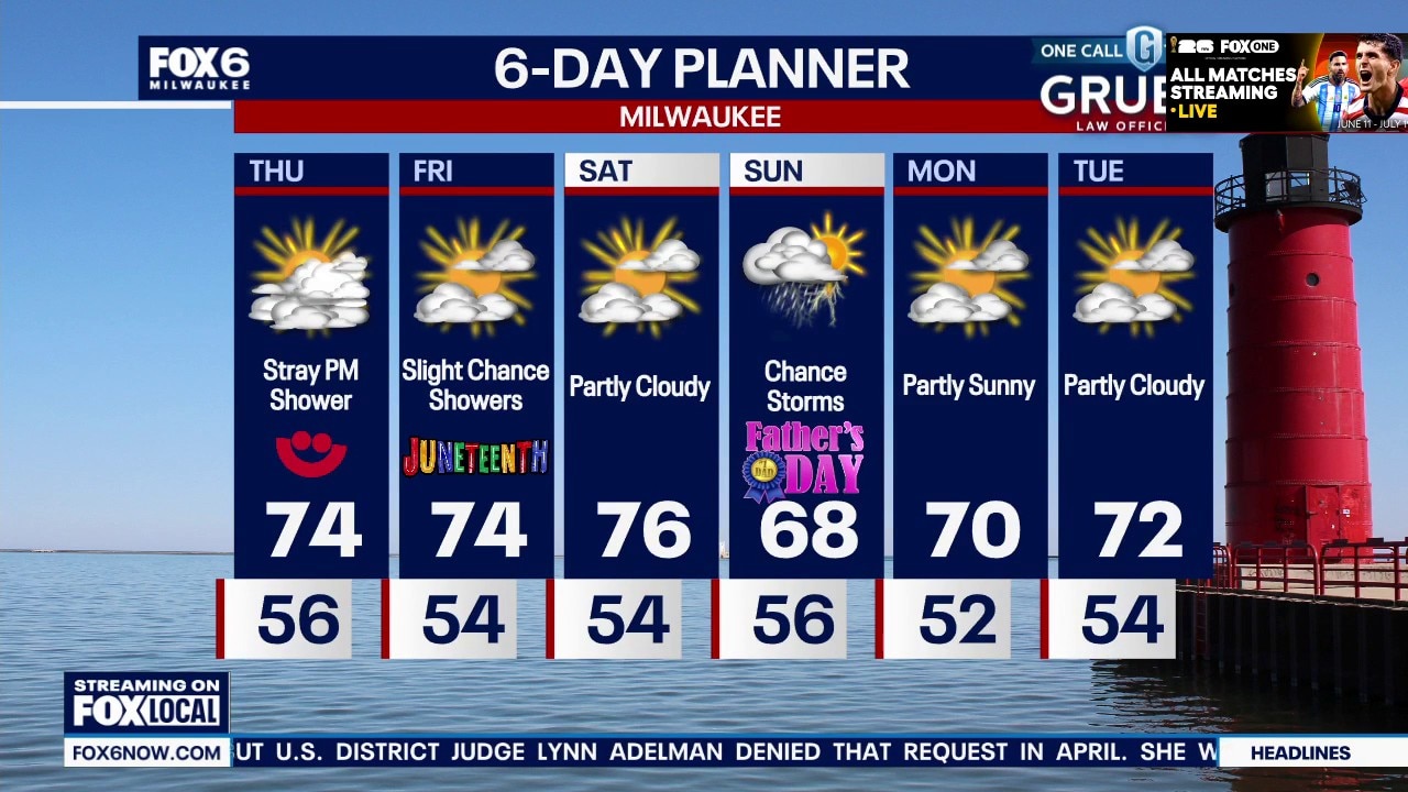
Scattered showers with a few thunderstorms expected this evening, plus cool with temperatures in the 50s. A few sprinkles may linger Thursday morning, then there is a chance of a stray late evening shower. Slight chance of showers Friday, then better chance on Sunday.
Scattered showers with a few thunderstorms expected this evening, plus cool with temperatures in the 50s. A few sprinkles may linger Thursday morning, then there is a chance of a stray late evening shower. Slight chance of showers Friday, then better chance on Sunday.

Tropical Storm Arthur makes landfall on Texas coast
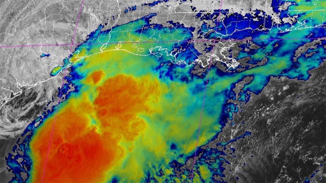
Tropical Storm Arthur has made landfall on the Texas coast just hours after it formed.
Tropical Storm Arthur has made landfall on the Texas coast just hours after it formed.
Great Lakes extremes; storm recaps in the Midwest | The Isobar
Grab a drink and step inside the "hottest bar in town"—the ISOBAR! In this fast-paced episode, host Rob Haswell (Fox Milwaukee) is joined by J.D. Rudd (Fox Chicago) and Derek Kevra (Fox Detroit) to unpack a wildly active stretch of severe weather that shattered a bone-dry May across the Midwest. The team dives headfirst into the chaotic storm setups of June 9th through 11th. J.D. details how a brief afternoon clearing destabilized the atmosphere over Illinois, leading to a relentless outbreak of over 20 tornadoes, including intense EF3s and a fast-moving EF2 that skirted Midway Airport. Meanwhile, Rob recounts a harrowing first-hand experience from the Fox Milwaukee weather truck, which narrowly escaped deep flash flooding in Walworth County right before severe tornado warnings sparked widespread power outages for 40,000 Wisconsin residents. Over in Michigan, Derek shares a dramatic, life-saving rescue story on the Detroit River, where sudden 70-mph winds capsized seven sailboats and threw 20 people into the water. Beyond the immediate storm damage, the meteorologists discuss the seasonal physics of forecasting—explaining how fully leafed-out summer trees act like massive sails to catch the wind, and why baked, dry soil ironically triggers severe flash flooding. Finally, the trio laughs over the struggles of seasonal outlooks, pulling back the curtain on what "equal chances" and "average temperatures" actually mean when you are trapped in a constant loop of historic extremes. #weather #midwest #wisconsin
Grab a drink and step inside the "hottest bar in town"—the ISOBAR! In this fast-paced episode, host Rob Haswell (Fox Milwaukee) is joined by J.D. Rudd (Fox Chicago) and Derek Kevra (Fox Detroit) to unpack a wildly active stretch of severe weather that shattered a bone-dry May across the Midwest. The team dives headfirst into the chaotic storm setups of June 9th through 11th. J.D. details how a brief afternoon clearing destabilized the atmosphere over Illinois, leading to a relentless outbreak of over 20 tornadoes, including intense EF3s and a fast-moving EF2 that skirted Midway Airport. Meanwhile, Rob recounts a harrowing first-hand experience from the Fox Milwaukee weather truck, which narrowly escaped deep flash flooding in Walworth County right before severe tornado warnings sparked widespread power outages for 40,000 Wisconsin residents. Over in Michigan, Derek shares a dramatic, life-saving rescue story on the Detroit River, where sudden 70-mph winds capsized seven sailboats and threw 20 people into the water. Beyond the immediate storm damage, the meteorologists discuss the seasonal physics of forecasting—explaining how fully leafed-out summer trees act like massive sails to catch the wind, and why baked, dry soil ironically triggers severe flash flooding. Finally, the trio laughs over the struggles of seasonal outlooks, pulling back the curtain on what "equal chances" and "average temperatures" actually mean when you are trapped in a constant loop of historic extremes. #weather #midwest #wisconsin
Weather webcast with Stephanie Barichello
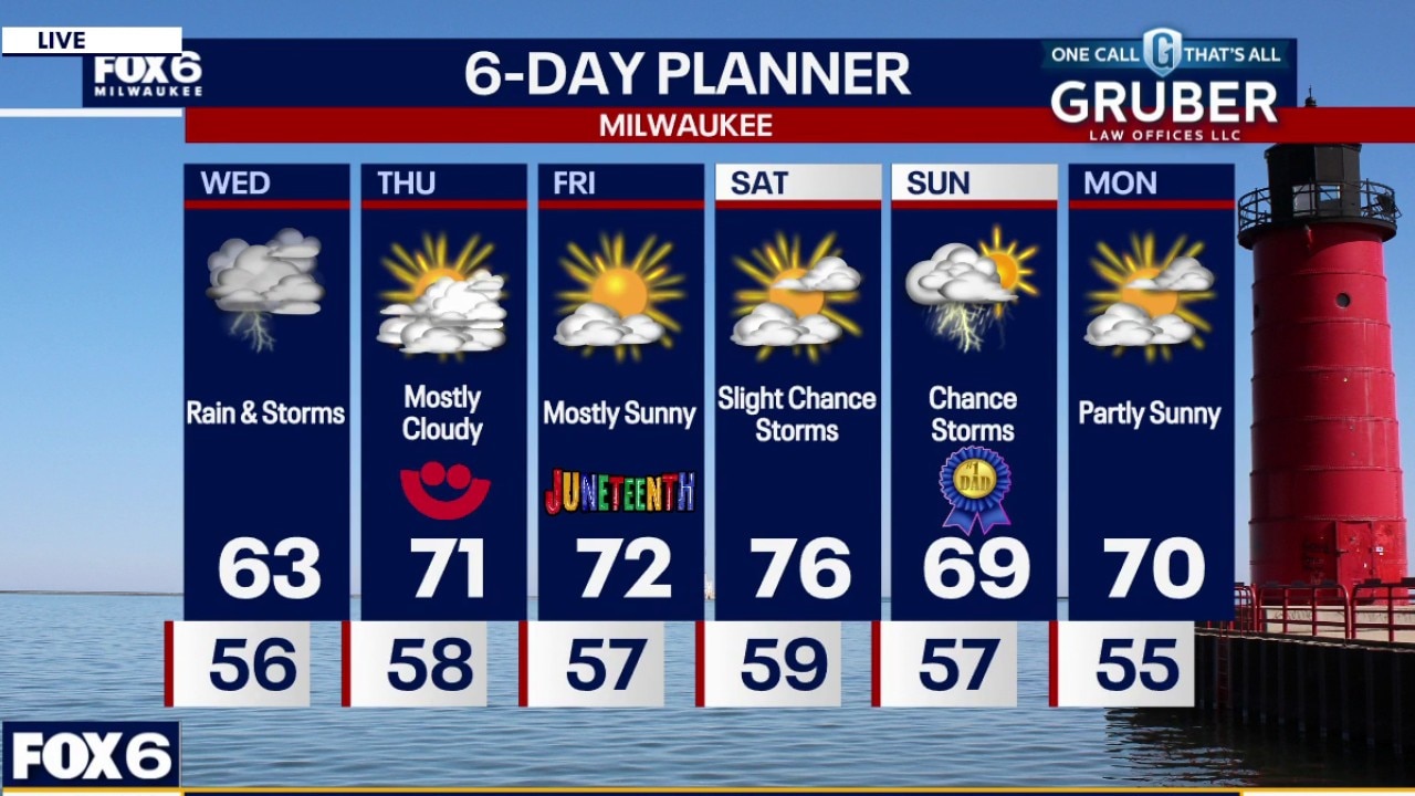
Morning rain likely with pockets of heavy rain. Highs will reach the lower 60s on Wednesday. Showers and t-storms likely on Wednesday with heavy rain. 1-2" possible Milwaukee and south, 0.50"-1.0" north of Milwaukee.
Morning rain likely with pockets of heavy rain. Highs will reach the lower 60s on Wednesday. Showers and t-storms likely on Wednesday with heavy rain. 1-2" possible Milwaukee and south, 0.50"-1.0" north of Milwaukee.
Weather webcast with Lisa Michaels
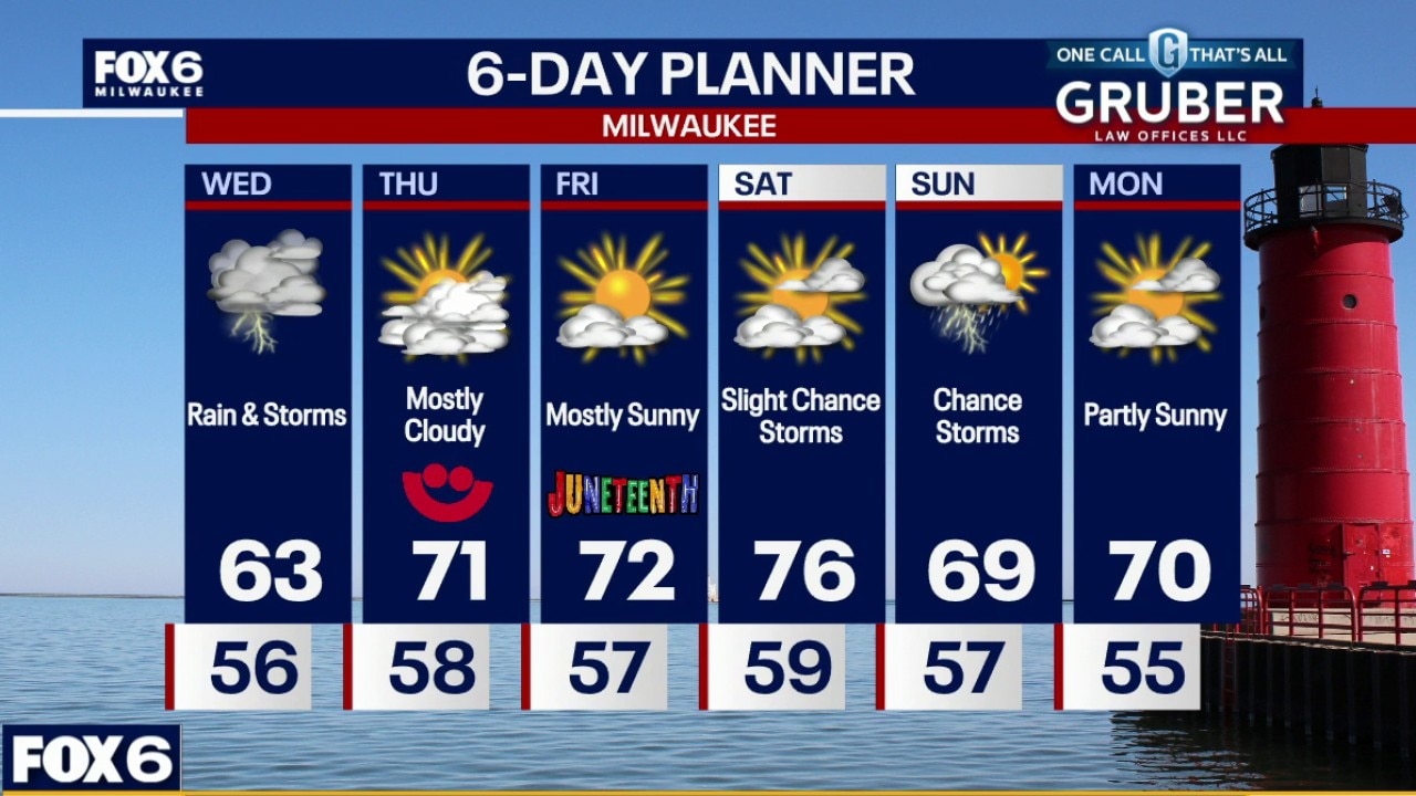
Morning rain likely with pockets of heavy rain. Highs will reach the lower 60s on Wednesday. Showers and t-storms likely on Wednesday with heavy rain. 1-2" possible Milwaukee and south, 0.50"-1.0" north of Milwaukee.
Morning rain likely with pockets of heavy rain. Highs will reach the lower 60s on Wednesday. Showers and t-storms likely on Wednesday with heavy rain. 1-2" possible Milwaukee and south, 0.50"-1.0" north of Milwaukee.
Weather Webcast with Chief Meteorologist Tom Wachs
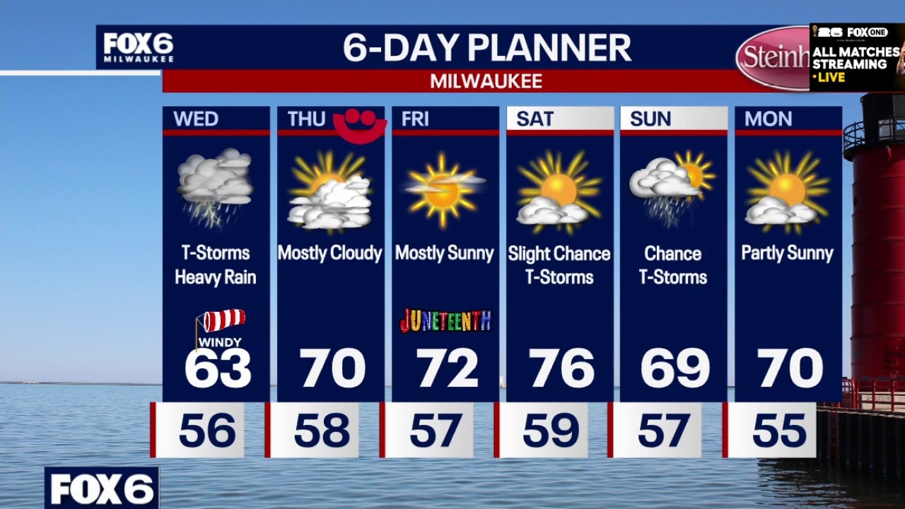
Increasing clouds overnight with temperatures dropping into the 50s. Showers and t-storms likely on Wednesday with heavy rain. 1-2" possible Milwaukee and south, 0.50"-1.0" north of Milwaukee. Cool and windy with highs in the low 60s. Severe weather risk is low, but there is a chance for wind/hail with storms mainly near the IL border. T-Storm chances continue on Wednesday night.
Increasing clouds overnight with temperatures dropping into the 50s. Showers and t-storms likely on Wednesday with heavy rain. 1-2" possible Milwaukee and south, 0.50"-1.0" north of Milwaukee. Cool and windy with highs in the low 60s. Severe weather risk is low, but there is a chance for wind/hail with storms mainly near the IL border. T-Storm chances continue on Wednesday night.
Milwaukee Weather: Cool with heavy rain on Wednesday
Increasing clouds overnight with temperatures dropping into the 50s. Showers and t-storms likely on Wednesday with heavy rain. 1-2" possible Milwaukee and south, 0.50"-1.0" north of Milwaukee. Cool and windy with highs in the low 60s. Severe weather risk is low, but there is a chance for wind/hail with storms mainly near the IL border. T-Storm chances continue on Wednesday night.
Increasing clouds overnight with temperatures dropping into the 50s. Showers and t-storms likely on Wednesday with heavy rain. 1-2" possible Milwaukee and south, 0.50"-1.0" north of Milwaukee. Cool and windy with highs in the low 60s. Severe weather risk is low, but there is a chance for wind/hail with storms mainly near the IL border. T-Storm chances continue on Wednesday night.
Weather Webcast with Chief Meteorologist Tom Wachs
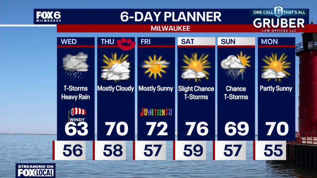
Scattered t-storms ending this evening. Mostly cloudy with temperatures dropping through the 60s. Showers and t-storms likely on Wednesday with heavy rain. 1-2" possible Milwaukee and south, 0.50"-1.0" north of Milwaukee. Cool and windy with highs in the low 60s. Severe weather risk is low, but there is a chance for wind/hail with storms mainly near the IL border. T-Storm chances continue on Wednesday night.
Scattered t-storms ending this evening. Mostly cloudy with temperatures dropping through the 60s. Showers and t-storms likely on Wednesday with heavy rain. 1-2" possible Milwaukee and south, 0.50"-1.0" north of Milwaukee. Cool and windy with highs in the low 60s. Severe weather risk is low, but there is a chance for wind/hail with storms mainly near the IL border. T-Storm chances continue on Wednesday night.
Weather Webcast with Stephanie Barichello
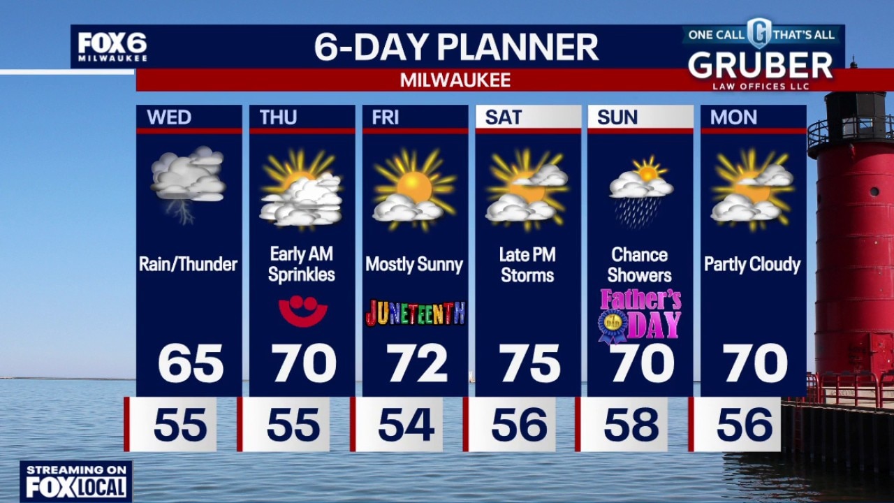
A few spotty showers this evening, then multiple rounds of potentially heavy rain on Wednesday. There is a chance of strong to severe storms late in the afternoon and evening, although the main threat is south in IL. Regardless, some gusty wind and hail cannot be ruled out late in the day. Sunshine returns the rest of the week.
A few spotty showers this evening, then multiple rounds of potentially heavy rain on Wednesday. There is a chance of strong to severe storms late in the afternoon and evening, although the main threat is south in IL. Regardless, some gusty wind and hail cannot be ruled out late in the day. Sunshine returns the rest of the week.
Weather webcast with Stephanie Barichello
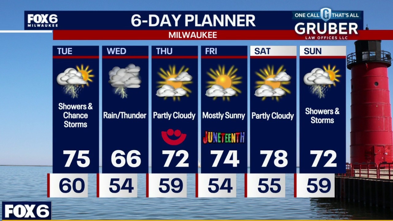
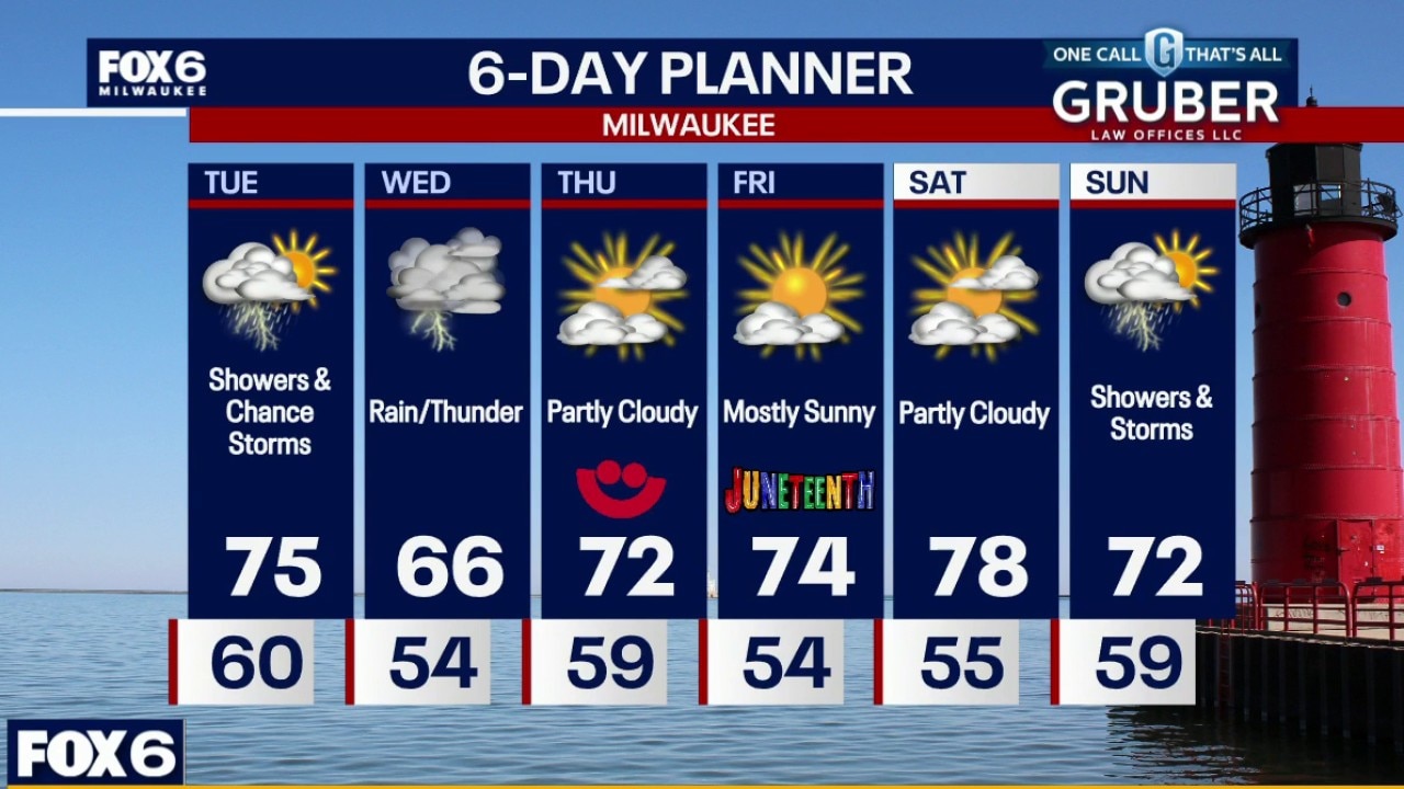
Southern Wisconsin is heading into an active stretch of weather with showers and thunderstorms developing Tuesday afternoon, followed by a more widespread rain event Wednesday and Wednesday night.
Southern Wisconsin is heading into an active stretch of weather with showers and thunderstorms developing Tuesday afternoon, followed by a more widespread rain event Wednesday and Wednesday night.
Weather webcast with Stephanie Barichello
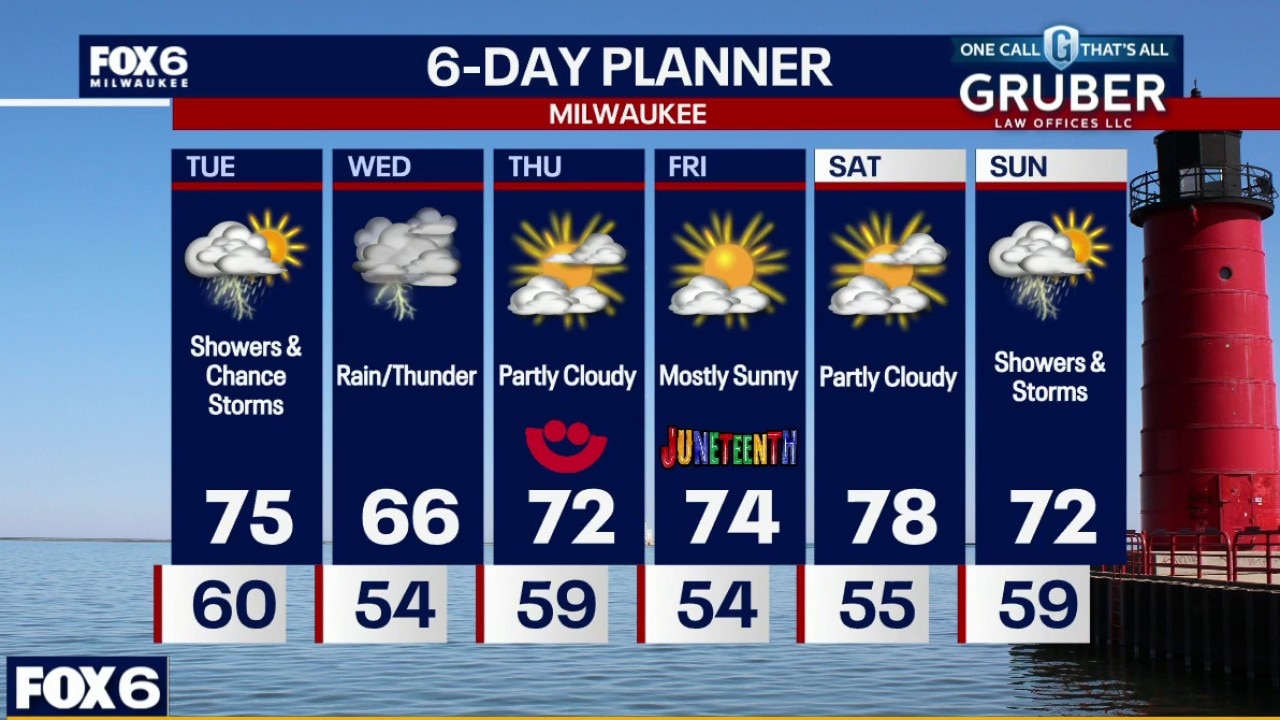
Southern Wisconsin is heading into an active stretch of weather with showers and thunderstorms developing Tuesday afternoon, followed by a more widespread rain event Wednesday and Wednesday night.
Southern Wisconsin is heading into an active stretch of weather with showers and thunderstorms developing Tuesday afternoon, followed by a more widespread rain event Wednesday and Wednesday night.
Weather webcast with Stephanie Barichello
Southern Wisconsin is heading into an active stretch of weather with showers and thunderstorms developing Tuesday afternoon, followed by a more widespread rain event Wednesday and Wednesday night.
Southern Wisconsin is heading into an active stretch of weather with showers and thunderstorms developing Tuesday afternoon, followed by a more widespread rain event Wednesday and Wednesday night.

Americans expected to pay more to cool homes this summer, new research finds
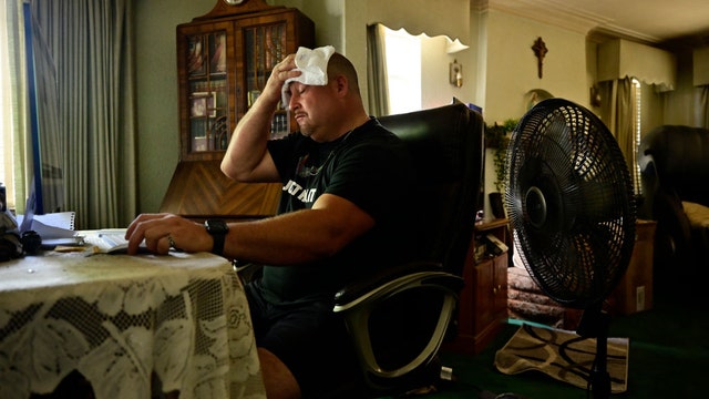
Staying cool this summer is about to become an expensive necessity for Americans with residential cooling expenses soaring for the average family to use their air conditioning units, according to a new report.
Staying cool this summer is about to become an expensive necessity for Americans with residential cooling expenses soaring for the average family to use their air conditioning units, according to a new report.

Southeast Wisconsin: Severe storms possible on Wednesday
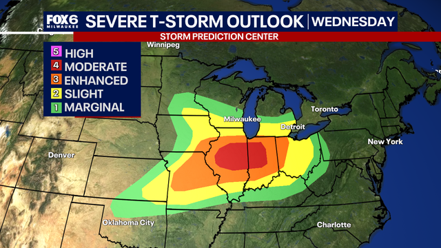
Keep an eye on the sky this Wednesday—we might see some strong to severe storms rolling in during the afternoon and evening.
Keep an eye on the sky this Wednesday—we might see some strong to severe storms rolling in during the afternoon and evening.
Weather webcast with Rob Haswell
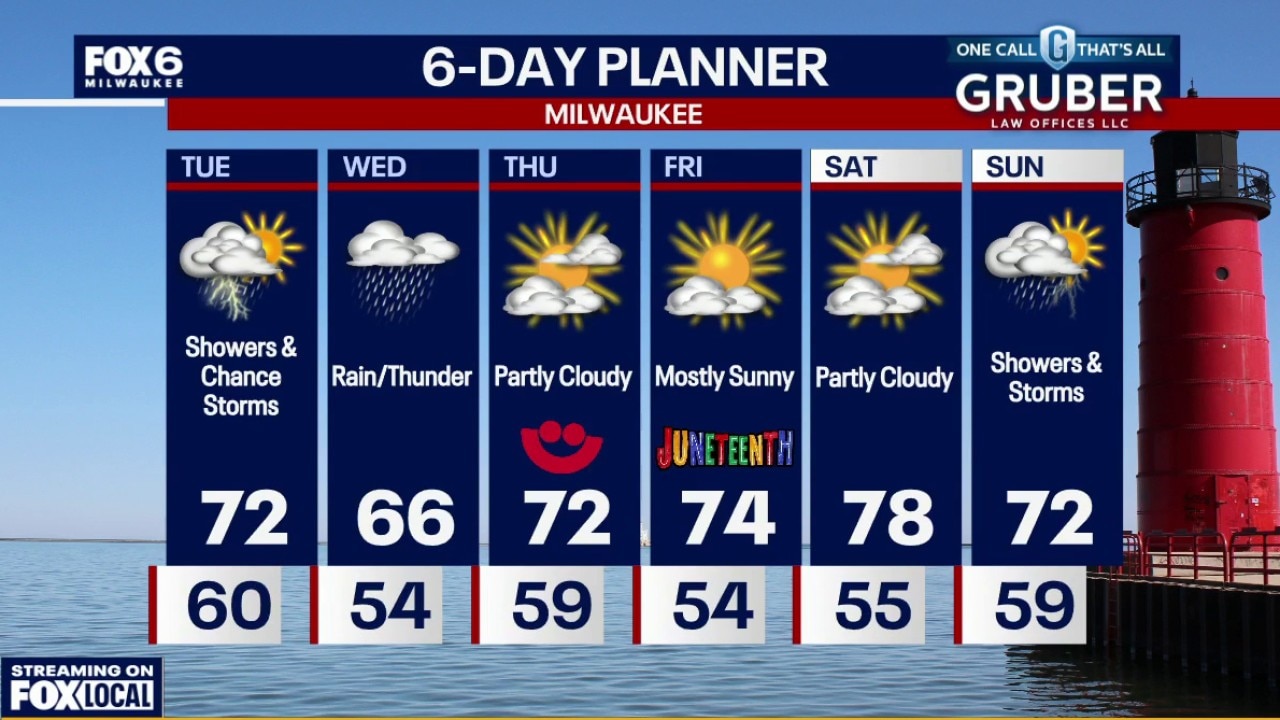
Southern Wisconsin is heading into an active stretch of weather with showers and thunderstorms developing Tuesday afternoon, followed by a more widespread rain event Wednesday and Wednesday night.
Southern Wisconsin is heading into an active stretch of weather with showers and thunderstorms developing Tuesday afternoon, followed by a more widespread rain event Wednesday and Wednesday night.
Weather Webcast with Chief Meteorologist Tom Wachs
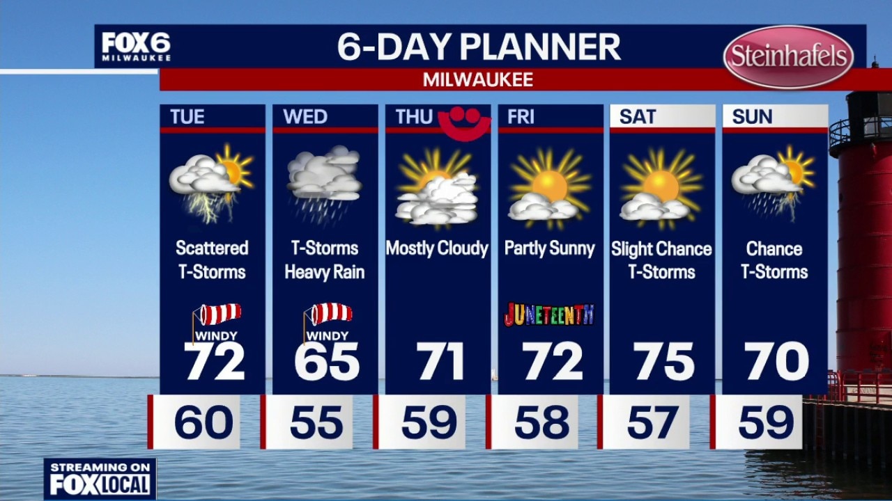
Increasing clouds overnight with temperatures dropping through the 60s. Scattered showers and t-storms on Tuesday starting after 5am and ending after sunset. Don't expect much rain out of this as the storms will be widely scattered throughout the day. Highs in the low 70s with a gusty west wind.
Increasing clouds overnight with temperatures dropping through the 60s. Scattered showers and t-storms on Tuesday starting after 5am and ending after sunset. Don't expect much rain out of this as the storms will be widely scattered throughout the day. Highs in the low 70s with a gusty west wind.