


Weather Webcast with Stephanie Barichello
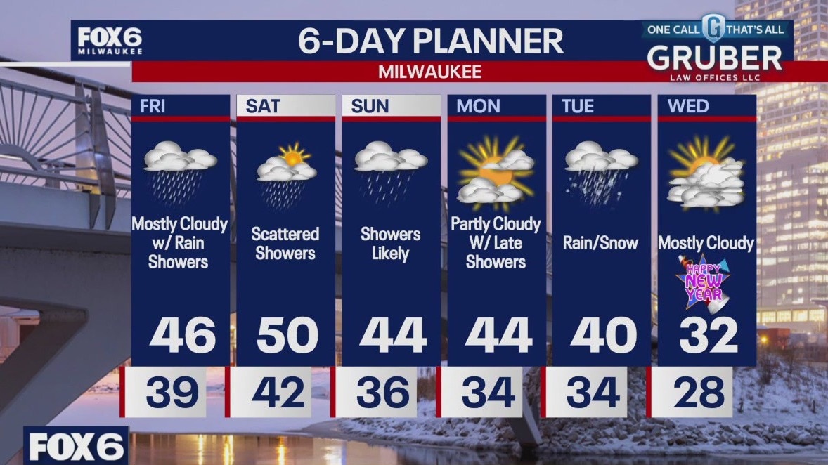
Sunny and mild today with high temperatures in the middle and upper 40s. Clouds increase late in the day, then there is a chance for fog tonight along with rain/snow mix. Rain and some mix will linger into Tuesday, then a final push of moisture as light snow will move through Tuesday evening, something to be prepared for if traveling for New Year's Eve. Much colder air filters in the rest of the week.
Sunny and mild today with high temperatures in the middle and upper 40s. Clouds increase late in the day, then there is a chance for fog tonight along with rain/snow mix. Rain and some mix will linger into Tuesday, then a final push of moisture as light snow will move through Tuesday evening, something to be prepared for if traveling for New Year's Eve. Much colder air filters in the rest of the week.
Weather webcast with Lisa Michaels
Monday will have more sunshine near the lake and slightly more clouds inland. Highs temps will be in the upper 30s to low 40s.
Monday will have more sunshine near the lake and slightly more clouds inland. Highs temps will be in the upper 30s to low 40s.

Weather Webcast with Chief Meteorologist Tom Wachs
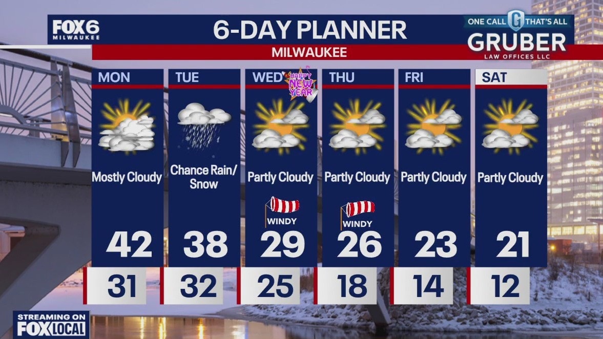
Areas of dense fog overnight with temperatures in the 20s and 30s. AM fog on Monday otherwise partly to mostly cloudy. Highs in the low 40s. Rain and snow showers are possible Monday night and Tuesday.
Areas of dense fog overnight with temperatures in the 20s and 30s. AM fog on Monday otherwise partly to mostly cloudy. Highs in the low 40s. Rain and snow showers are possible Monday night and Tuesday.
Weather Webcast with Chief Meteorologist Tom Wachs
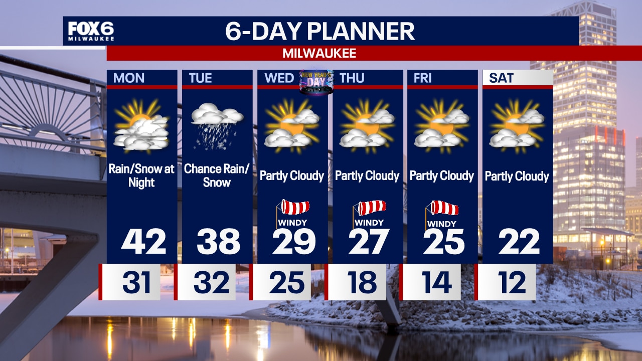
Areas of fog tonight with temperatures dropping into the upper 20s to low 30s by morning. AM fog with some peeks of afternoon sun possible on Monday. Highs in the low 40s. A big cool down starts on New Year's Day.
Areas of fog tonight with temperatures dropping into the upper 20s to low 30s by morning. AM fog with some peeks of afternoon sun possible on Monday. Highs in the low 40s. A big cool down starts on New Year's Day.
Weather webcast with Lisa Michaels
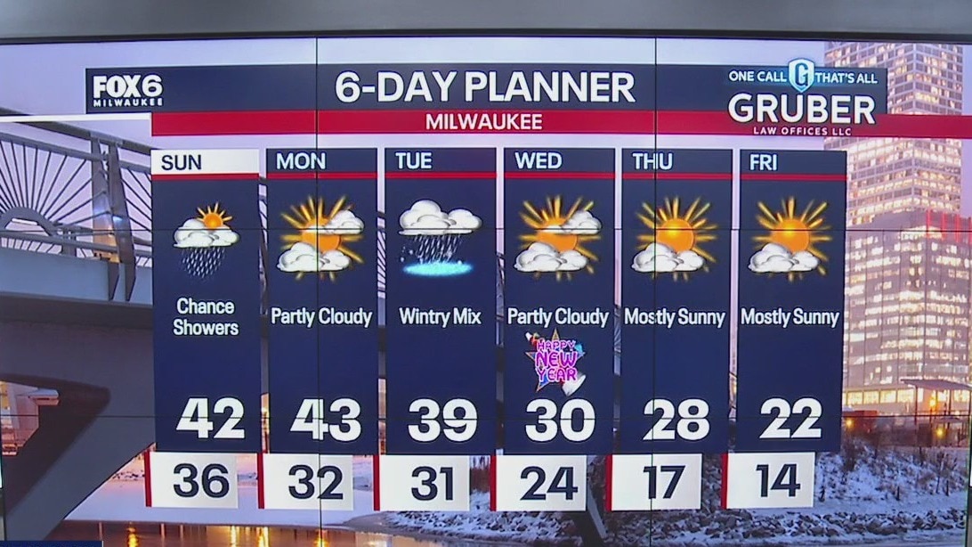
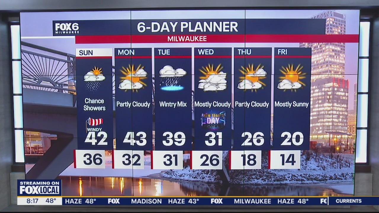
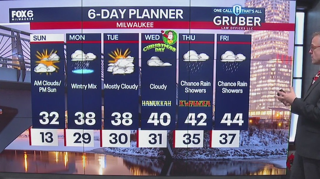
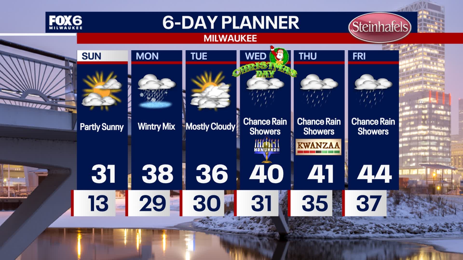
Cloudy skies Sunday with a chance of showers near the lake on the backside of a low pressure system. Highs will be in the upper 30s to low 40s.
Cloudy skies Sunday with a chance of showers near the lake on the backside of a low pressure system. Highs will be in the upper 30s to low 40s.

Weather Webcast with Holly Baker
Fog returns to the forecast tonight and tomorrow morning with cooler temps not to far behind.
Fog returns to the forecast tonight and tomorrow morning with cooler temps not to far behind.
Weather webcast with Lisa Michaels
Mostly cloudy skies in the morning with decreasing clouds through the day. Chance of fog again Saturday night.
Mostly cloudy skies in the morning with decreasing clouds through the day. Chance of fog again Saturday night.

Webcast Weather with Holly Baker
A soggy weekend with mild temperatures are expected over the weekend.
A soggy weekend with mild temperatures are expected over the weekend.
Weather webcast with Rob Haswell
Drizzle and fog will make way for steadier rain later today and tonight. Around 0.5" is expected.
Drizzle and fog will make way for steadier rain later today and tonight. Around 0.5" is expected.

Webcast Weather with Holly Baker
A dense fog advisory continues through tomorrow with more rain on the way.
A dense fog advisory continues through tomorrow with more rain on the way.
Weather webcast with Rob Haswell
Drizzle and fog will persist for much of the day with a steadier rain developing later today and tonight.
Drizzle and fog will persist for much of the day with a steadier rain developing later today and tonight.
Weather webcast with Lisa Michaels
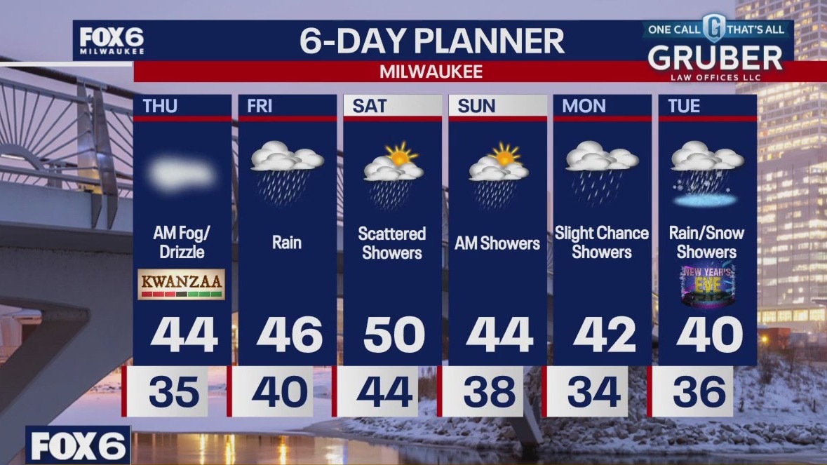
Cloudy tonight with chance of drizzle/freezing drizzle north. With light winds tonight, fog and freezing fog is possible. Temp will begin to warm early Thursday morning. Cloudy skies on Friday with rain increasing Friday night into Saturday. Amounts can range 0.2"-0.5", An extended chance of rain is favorable each day through New Year's Eve. Temperatures warming into the upper 40s by6 the weekend before cooler air returns for the start of the new year.
Cloudy tonight with chance of drizzle/freezing drizzle north. With light winds tonight, fog and freezing fog is possible. Temp will begin to warm early Thursday morning. Cloudy skies on Friday with rain increasing Friday night into Saturday. Amounts can range 0.2"-0.5", An extended chance of rain is favorable each day through New Year's Eve. Temperatures warming into the upper 40s by6 the weekend before cooler air returns for the start of the new year.

Weather webcast with Holly Baker
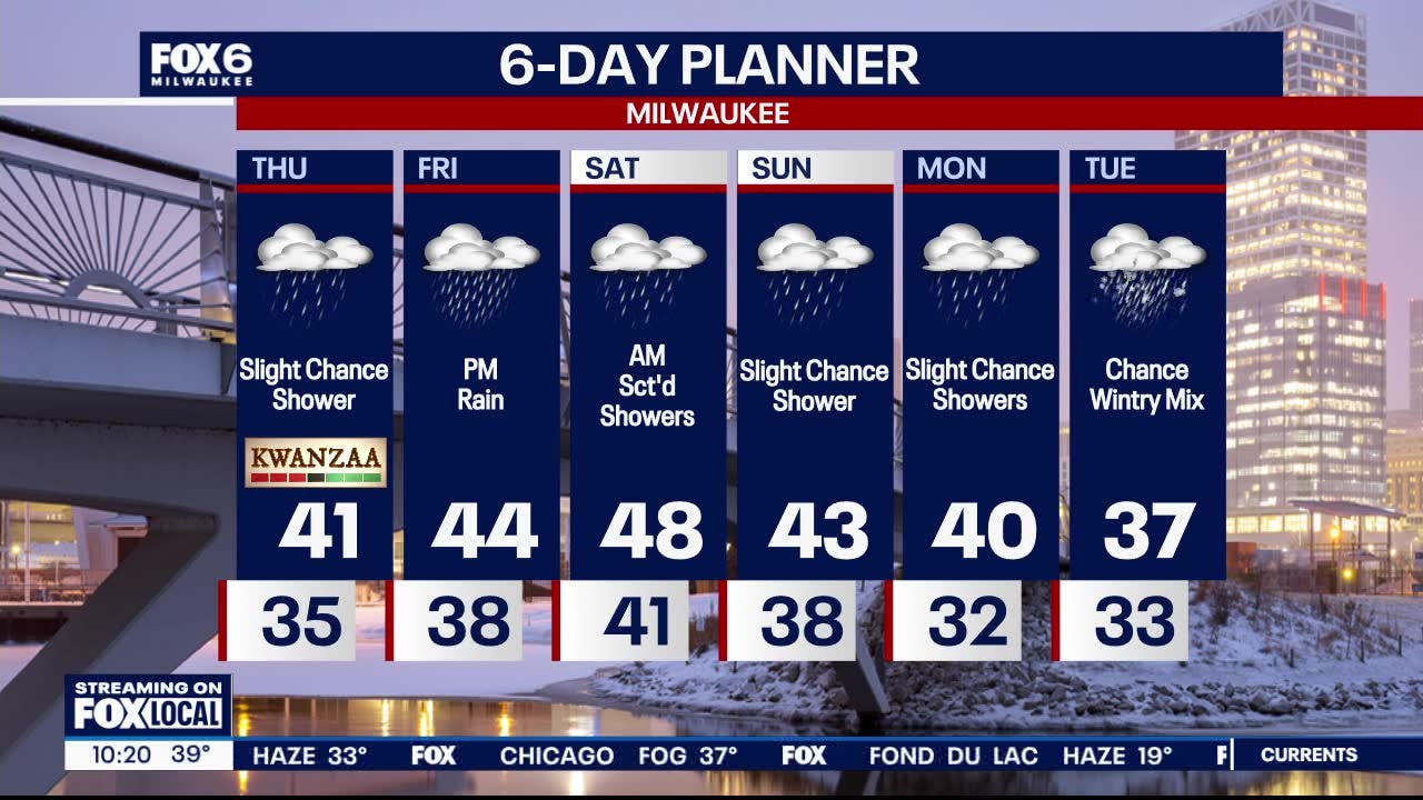
Some communities in SE Wisconsin will get a nice Christmas gift this morning! A WHITE CHRISTMAS!! A chance for slight drizzle is likely during Christmas Day. However, clouds will dominate the forecast. Rain returns in the forecast by Thursday afternoon into the weekend. Drier conditions by the start of next week. Temperatures warm up to the mid to upper 40s and 50 for the end of the week into the weekend.
Some communities in SE Wisconsin will get a nice Christmas gift this morning! A WHITE CHRISTMAS!! A chance for slight drizzle is likely during Christmas Day. However, clouds will dominate the forecast. Rain returns in the forecast by Thursday afternoon into the weekend. Drier conditions by the start of next week. Temperatures warm up to the mid to upper 40s and 50 for the end of the week into the weekend.

Weather Webcast with Holly Baker
A "White Christmas" is on the way with a warm up to follow.
A "White Christmas" is on the way with a warm up to follow.
Weather webcast with Rob Haswell
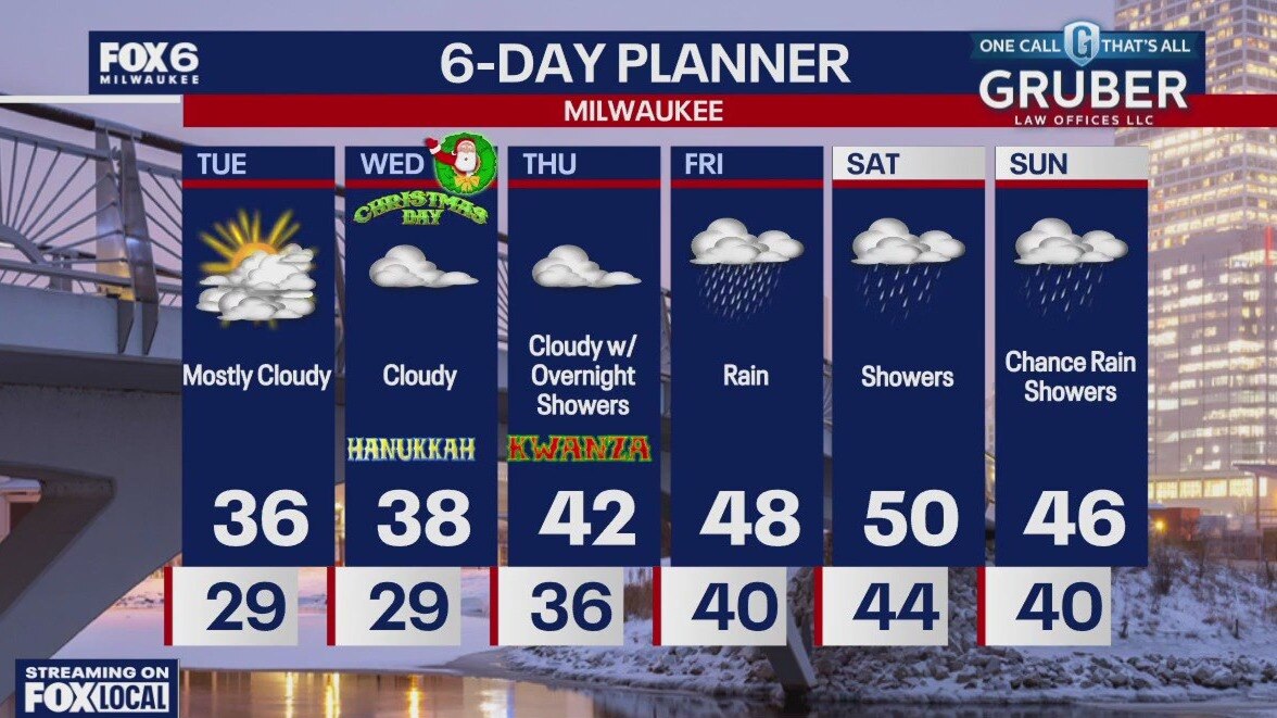
A mild but cloudy last day before Christmas with highs in the mid to upper 30s likely. We stay cloudy overnight with lows in the mid to upper 20s then warm into the upper 30s for Christmas Day but remain cloudy. There is a slight chance for some patchy drizzle or an isolated flurry on Christmas Day but otherwise calm. We warm into the low 40s Thursday and upper 40s Friday with a high near 50 likely Saturday!
A mild but cloudy last day before Christmas with highs in the mid to upper 30s likely. We stay cloudy overnight with lows in the mid to upper 20s then warm into the upper 30s for Christmas Day but remain cloudy. There is a slight chance for some patchy drizzle or an isolated flurry on Christmas Day but otherwise calm. We warm into the low 40s Thursday and upper 40s Friday with a high near 50 likely Saturday!

Webcast Weather with Holly Baker
A warm up in temperatures is on the way.
A warm up in temperatures is on the way.

Weather webcast with Rob Haswell
A winter weather advisory will be in effect start at 9 a.m. today until 6 p.m. Biggest threat is for some icing due to a wintry mix including freezing drizzle through parts of the day. We warm a little again today with highs in the mid to upper 30s. We stay in the mid to upper 30s Tuesday and Wednesday. Snow cover will steadily melt but some areas will retain enough for a "White Christmas". We hit the 40s later this week.
A winter weather advisory will be in effect start at 9 a.m. today until 6 p.m. Biggest threat is for some icing due to a wintry mix including freezing drizzle through parts of the day. We warm a little again today with highs in the mid to upper 30s. We stay in the mid to upper 30s Tuesday and Wednesday. Snow cover will steadily melt but some areas will retain enough for a "White Christmas". We hit the 40s later this week.

Weather Webcast with Holly Baker
A winter weather advisory will be in effect starting at 3AM.
A winter weather advisory will be in effect starting at 3AM.
Weather webcast with Rob Haswell
We should see some sun today but drizzle and freezing drizzle are possible overnight.
We should see some sun today but drizzle and freezing drizzle are possible overnight.
Weather Webcast with Holly Baker
Temperatures are on a rise!
Temperatures are on a rise!