


Weather webcast with Lisa Michaels
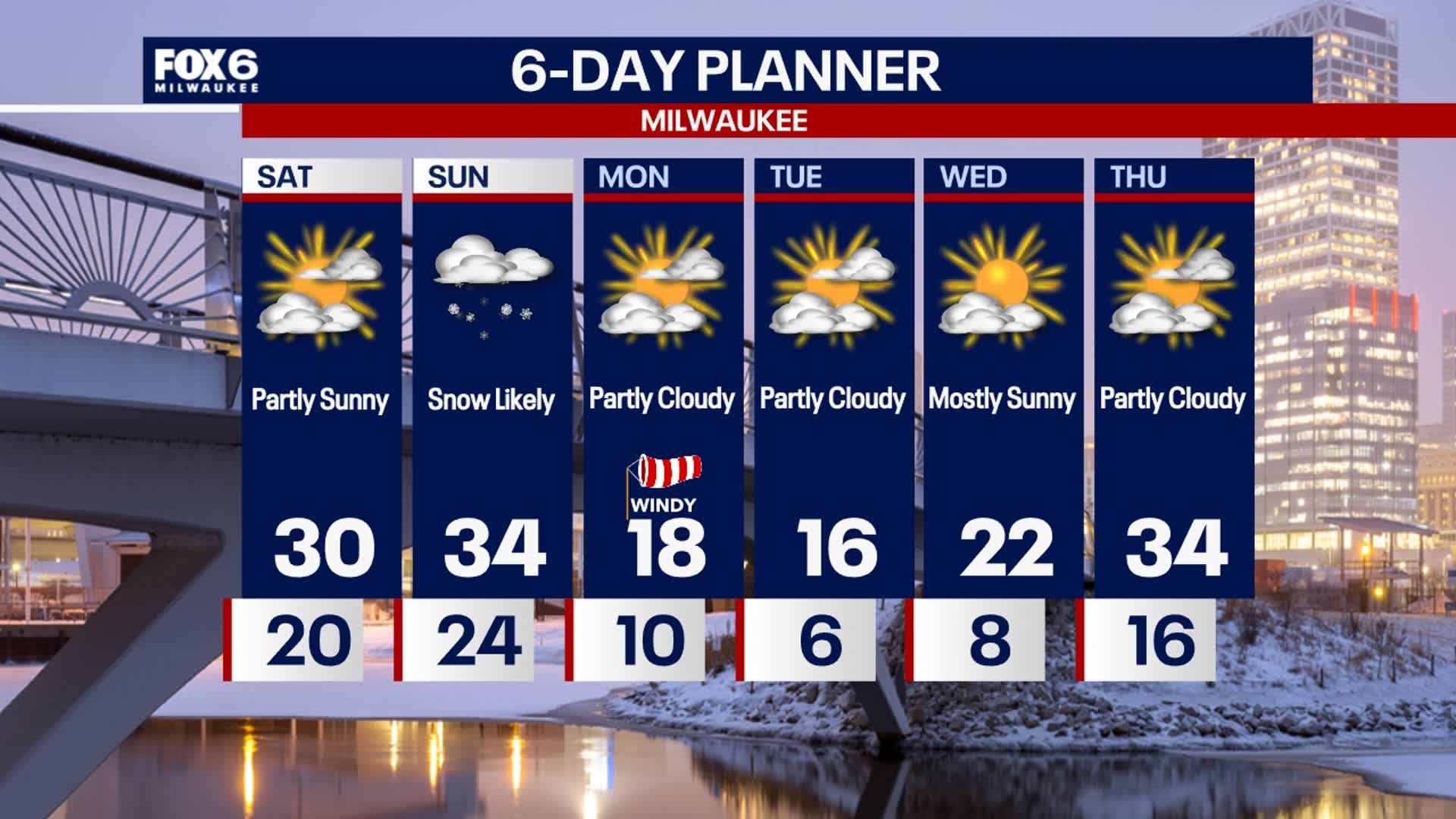
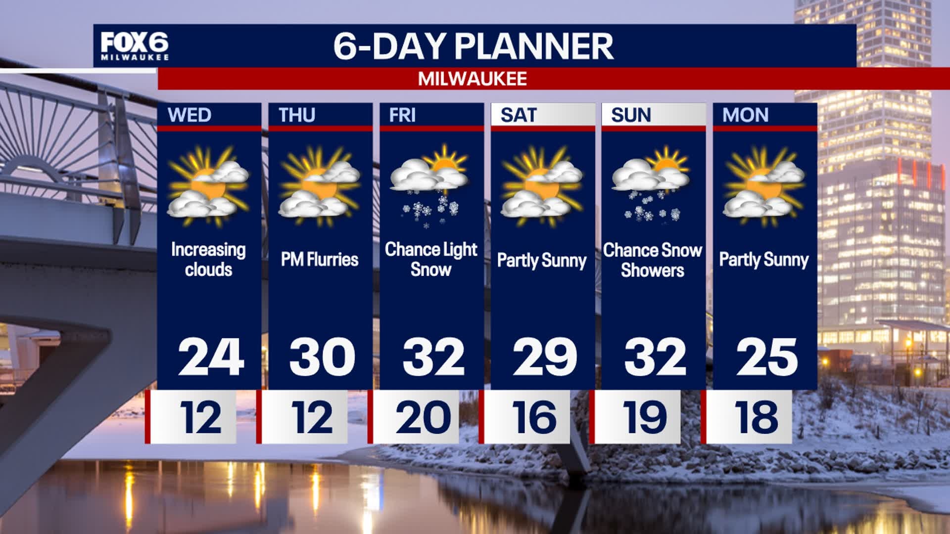
Clouds early Saturday then gradually decreasing for the day. Increasing clouds again late this afternoon into tonight. Highs in the upper 20s to low 30s. Clouds increase tonight with the approach of another low-pressure system. This will bring snow after 10PM through midday Sunday. Snow will begin to accumulate after midnight. 1-2" of snowfall accumulation will be possible with isolated areas inland that can be closer to 3". Colder air returns early next week with highs back in the teens and lows in the single digits. Wind chills back below zero Monday into Tuesday.
Clouds early Saturday then gradually decreasing for the day. Increasing clouds again late this afternoon into tonight. Highs in the upper 20s to low 30s. Clouds increase tonight with the approach of another low-pressure system. This will bring snow after 10PM through midday Sunday. Snow will begin to accumulate after midnight. 1-2" of snowfall accumulation will be possible with isolated areas inland that can be closer to 3". Colder air returns early next week with highs back in the teens and lows in the single digits. Wind chills back below zero Monday into Tuesday.
Weather Webcast with Stephanie Barichello
Some sun to start Saturday then snow returns Saturday night into Sunday morning. 1-3" will be possible, with highest totals across northern counties. Cold early next week, but a quiet week ahead.
Some sun to start Saturday then snow returns Saturday night into Sunday morning. 1-3" will be possible, with highest totals across northern counties. Cold early next week, but a quiet week ahead.

Weather webcast with Lisa Michaels
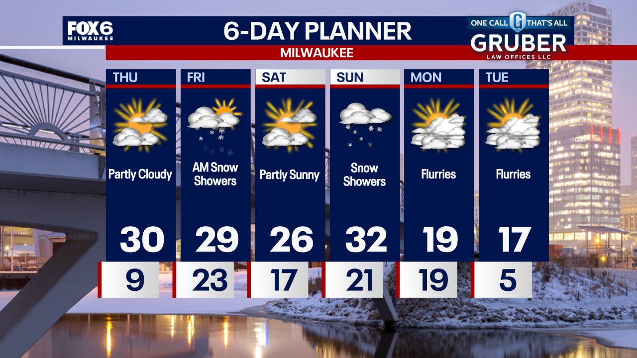
A weak cold front moving through today could generate a few snow showers or some before we clear out this afternoon. A few flurries possible tonight. Highs will once again be near average. Our next chance for snow comes Saturday night into Sunday with a couple of inches possible. Colder air returns early next week with highs back in the teens and lows in the single digits.
A weak cold front moving through today could generate a few snow showers or some before we clear out this afternoon. A few flurries possible tonight. Highs will once again be near average. Our next chance for snow comes Saturday night into Sunday with a couple of inches possible. Colder air returns early next week with highs back in the teens and lows in the single digits.

Weather webcast with Rob Haswell
A weak cold front moving through today could generate a few snow showers or some patchy freezing drizzle early today before we clear out this afternoon. Highs will once again be near average. Our next chance for snow comes Saturday night into Sunday with a couple of inches possible. Colder air returns early next week with highs back in the teens and lows in the single digits.
A weak cold front moving through today could generate a few snow showers or some patchy freezing drizzle early today before we clear out this afternoon. Highs will once again be near average. Our next chance for snow comes Saturday night into Sunday with a couple of inches possible. Colder air returns early next week with highs back in the teens and lows in the single digits.
Weather Webcast with Chief Meteorologist Tom Wachs
Freezing drizzle possible overnight with a few icy patches. Temperatures in the 20s. Light snow on Friday morning, ending by midday. Around 0.50" of snow possible. Highs in the low 30s on Friday. There is another chance for snow on Sunday.
Freezing drizzle possible overnight with a few icy patches. Temperatures in the 20s. Light snow on Friday morning, ending by midday. Around 0.50" of snow possible. Highs in the low 30s on Friday. There is another chance for snow on Sunday.
Weather Webcast with Chief Meteorologist Tom Wachs
The wind will pick up tonight with freezing drizzle possible overnight. Temperatures in the 20s tonight. Light snow on Friday morning with up to. 0.50" of accumulation. Light snow will end by midday. Highs in the low 30s. There is another chance for snow accumulation on Sunday.
The wind will pick up tonight with freezing drizzle possible overnight. Temperatures in the 20s tonight. Light snow on Friday morning with up to. 0.50" of accumulation. Light snow will end by midday. Highs in the low 30s. There is another chance for snow accumulation on Sunday.

Weather webcast with Holly Baker
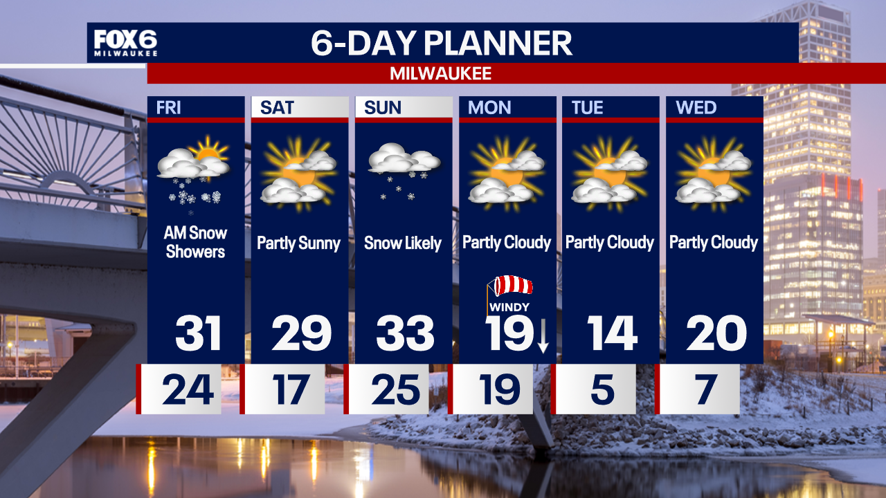
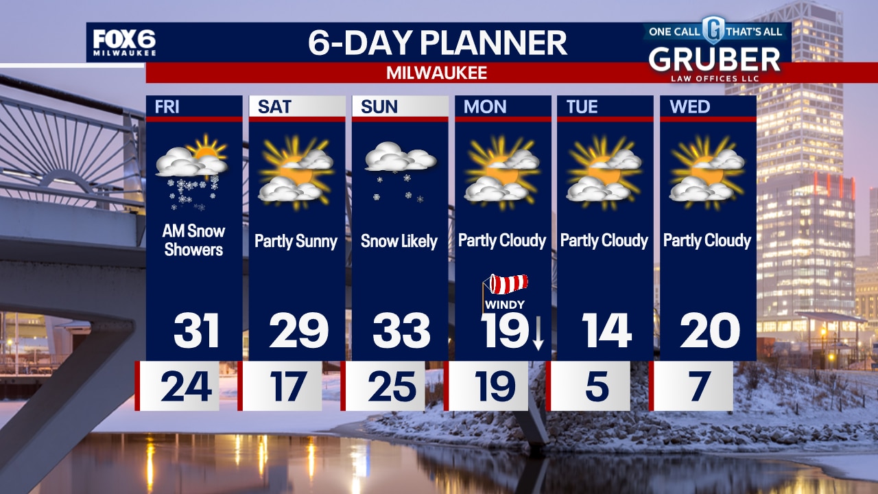
Skies will be mostly sunny today with increasing clouds this evening. Highs will be in the upper 20's. A chance for a light dusting of snow is likely overnight Thursday with more of a chance of snow Friday morning. Closer to normal temperatures are likely over the weekend. More snow arrives Sunday into Sunday night. Another wave of cold air arrives at the start of the week.
Skies will be mostly sunny today with increasing clouds this evening. Highs will be in the upper 20's. A chance for a light dusting of snow is likely overnight Thursday with more of a chance of snow Friday morning. Closer to normal temperatures are likely over the weekend. More snow arrives Sunday into Sunday night. Another wave of cold air arrives at the start of the week.
Weather Webcast with Chief Meteorologist Tom Wachs
Clear and cold overnight with temperatures in the single digits. Partly sunny on Thursday with a high around 30. Light snow showers are possible late Thursday night into Friday morning.
Clear and cold overnight with temperatures in the single digits. Partly sunny on Thursday with a high around 30. Light snow showers are possible late Thursday night into Friday morning.
Weather Webcast with Chief Meteorologist Tom Wachs
Clearing and cold tonight with temperatures dropping into the single digits overnight. Partly sunny on Thursday with a high around 30. Light snow is possible late Thursday night into Friday.
Clearing and cold tonight with temperatures dropping into the single digits overnight. Partly sunny on Thursday with a high around 30. Light snow is possible late Thursday night into Friday.
Weather Webcast with Stephanie Barichello
Mostly cloudy this afternoon and chilly with temperatures in the low 20s. Warming back into the 30s Thursday, then a chance for light snow at times on Friday. There is another chance for light snow on Sunday.
Mostly cloudy this afternoon and chilly with temperatures in the low 20s. Warming back into the 30s Thursday, then a chance for light snow at times on Friday. There is another chance for light snow on Sunday.

Weather webcast with Holly Baker
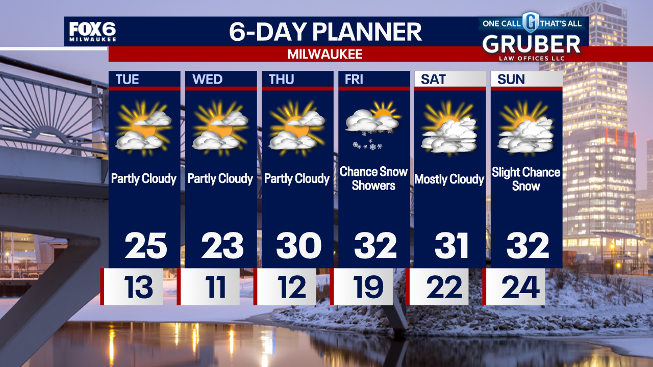
Below normal temperatures today. Mostly sunny skies and frigid temperatures prevail through Thursday with highs in the mid to upper 20's. Warmer temperatures in the 30's are expected late week into the weekend. There is a chance of light snow on Friday and again Sunday. Accumulations are expected to be below an inch. Temperatures will stay between upper 20s and low 30s into early next week.
Below normal temperatures today. Mostly sunny skies and frigid temperatures prevail through Thursday with highs in the mid to upper 20's. Warmer temperatures in the 30's are expected late week into the weekend. There is a chance of light snow on Friday and again Sunday. Accumulations are expected to be below an inch. Temperatures will stay between upper 20s and low 30s into early next week.
Weather Webcast with Chief Meteorologist Tom Wachs
Cold overnight with temperatures in the teens near the lake and single digits inland. Partly sunny on Wednesday with highs in the 20s. Our next chance for snow is on Friday.
Cold overnight with temperatures in the teens near the lake and single digits inland. Partly sunny on Wednesday with highs in the 20s. Our next chance for snow is on Friday.

Weather Webcast with Chief Meteorologist Tom Wachs
Clearing skies tonight with temperatures dropping into the single digits and teens overnight. Partly sunny and chilly on Wednesday with highs in the low-to-mid 20s.
Clearing skies tonight with temperatures dropping into the single digits and teens overnight. Partly sunny and chilly on Wednesday with highs in the low-to-mid 20s.

Weather webcast with Lisa Michaels
Partly cloudy on Tuesday with high temperatures in the low to mid 20s. Clouds increase during the afternoon. Warming up slightly near the end of the week with high temperatures back in the low 30s. Watching for the next chance of light snow to come possibly on Friday. Another chance of snow enters the forecast on Sunday.
Partly cloudy on Tuesday with high temperatures in the low to mid 20s. Clouds increase during the afternoon. Warming up slightly near the end of the week with high temperatures back in the low 30s. Watching for the next chance of light snow to come possibly on Friday. Another chance of snow enters the forecast on Sunday.
Weather Webcast with Chief Meteorologist Tom Wachs
Clear skies overnight with temperatures in the teens. Increasing clouds on Tuesday with a high in the mid-20s.
Clear skies overnight with temperatures in the teens. Increasing clouds on Tuesday with a high in the mid-20s.
Weather Webcast with Chief Meteorologist Tom Wachs
Clearing skies tonight with temperatures dropping into the teens overnight. Increasing clouds on Tuesday with highs in the low-to-mid 20s.
Clearing skies tonight with temperatures dropping into the teens overnight. Increasing clouds on Tuesday with highs in the low-to-mid 20s.
Weather Webcast with Stephanie Barichello
Lake effect snow has come to an end, with 1-5" across parts of Milwaukee, Racine and Kenosha County. There may still be icy spots as temperatures remain below freezing, including inland and north where there was freezing drizzle this morning. Quiet the rest of the week with 30s returning by Thursday and Friday.
Lake effect snow has come to an end, with 1-5" across parts of Milwaukee, Racine and Kenosha County. There may still be icy spots as temperatures remain below freezing, including inland and north where there was freezing drizzle this morning. Quiet the rest of the week with 30s returning by Thursday and Friday.
Weather webcast with Rob Haswell
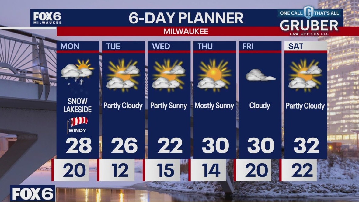
A Winter Weather Advisory is in place for Milwaukee, Racine and Kenosha counties until 4pm. Several inches of snow are possible lakeside in those areas. Areas away from Lake Michigan can expect a windy and cloudy day with highs in the upper 20s.
A Winter Weather Advisory is in place for Milwaukee, Racine and Kenosha counties until 4pm. Several inches of snow are possible lakeside in those areas. Areas away from Lake Michigan can expect a windy and cloudy day with highs in the upper 20s.
Weather Webcast with Chief Meteorologist Tom Wachs
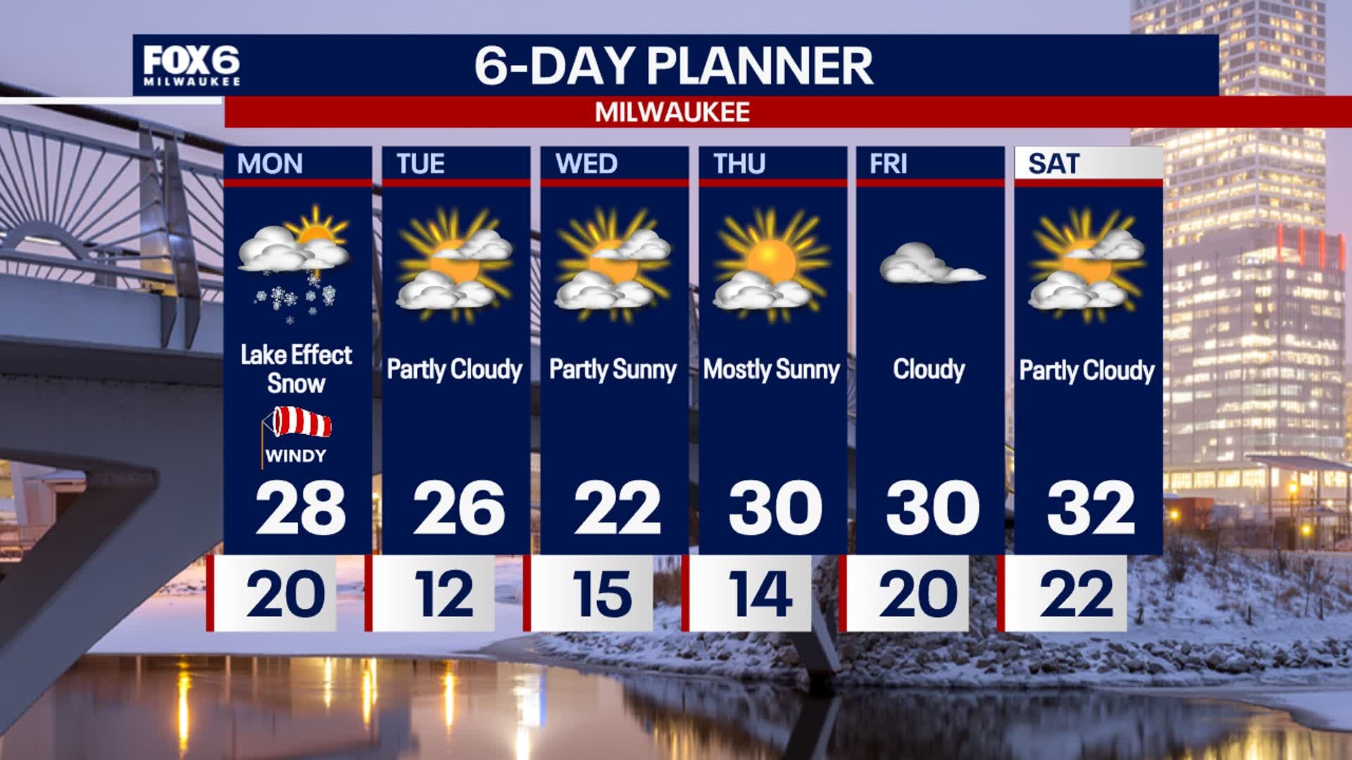
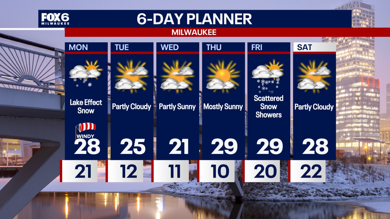
A lake effect snow band will develop overnight and continue until mid-afternoon Monday in Racine and Kenosha counties. There is some question as to whether the heavy snow band will push west into Milwaukee. Please stay up to date with the forecast on Monday.
A lake effect snow band will develop overnight and continue until mid-afternoon Monday in Racine and Kenosha counties. There is some question as to whether the heavy snow band will push west into Milwaukee. Please stay up to date with the forecast on Monday.

Weather Webcast with Chief Meteorologist Tom Wachs
A narrow band of lake effect snow will develop in Racine and Kenosha later this evening and continue through Monday afternoon. Little snow outside of that band. But over 4" is possible in Racine and Kenosha later tonight & Monday.
A narrow band of lake effect snow will develop in Racine and Kenosha later this evening and continue through Monday afternoon. Little snow outside of that band. But over 4" is possible in Racine and Kenosha later tonight & Monday.