

Weather Webcast with Chief Meteorologist Tom Wachs
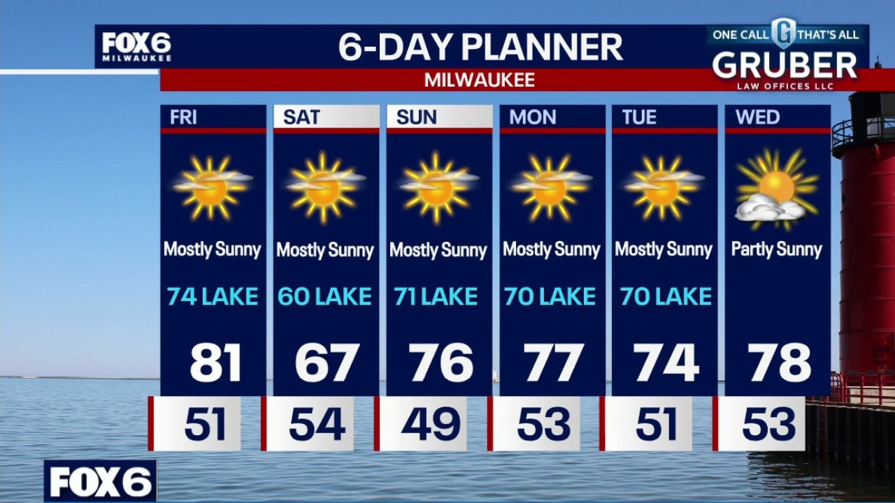
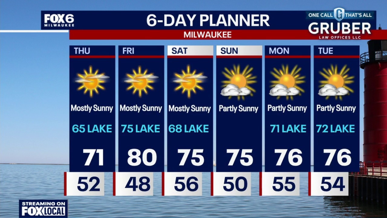
Clear skies tonight with temperatures dropping into the 50s and settling in the 40s overnight. Mostly sunny on Friday with a high around 80 inland, 74 near the lake. Much cooler on Saturday with highs in the 60s.
Clear skies tonight with temperatures dropping into the 50s and settling in the 40s overnight. Mostly sunny on Friday with a high around 80 inland, 74 near the lake. Much cooler on Saturday with highs in the 60s.
Weather webcast with Holly Baker
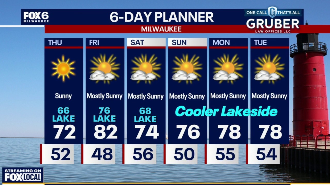
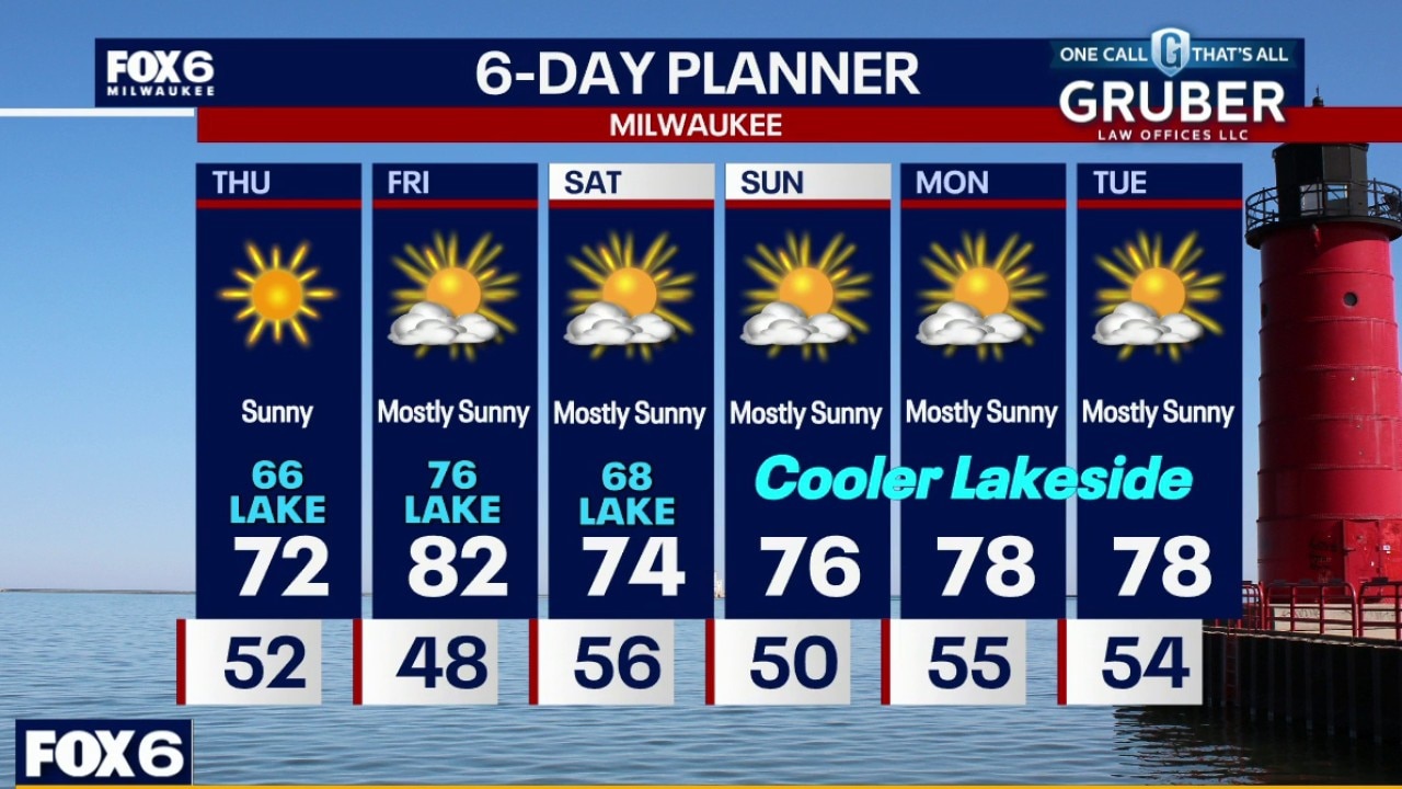
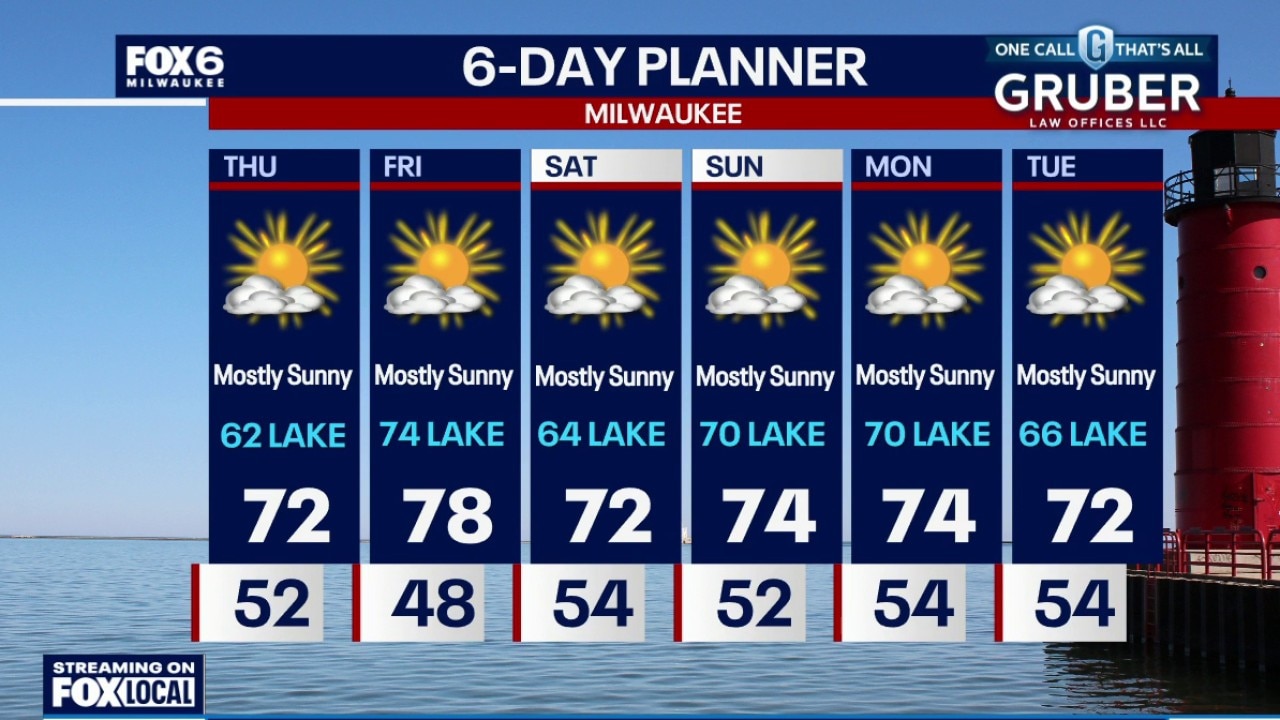
A much cooler setup settles in for Thursday as breezy north-east winds push highs near Lake Michigan into the 60s while inland spots still manage the 70s.
A much cooler setup settles in for Thursday as breezy north-east winds push highs near Lake Michigan into the 60s while inland spots still manage the 70s.
Weather webcast with Rob Haswell
A much cooler setup settles in for Thursday as breezy north-east winds push highs near Lake Michigan into the 60s while inland spots still manage the 70s.
A much cooler setup settles in for Thursday as breezy north-east winds push highs near Lake Michigan into the 60s while inland spots still manage the 70s.
Weather Webcast with Chief Meteorologist Tom Wachs
Mostly clear overnight. Temperatures will drop into the 50s overnight. Mostly sunny and breezy on Thursday with the wind off of the lake. Highs in the low 70s inland, mid-60s near the lake.
Mostly clear overnight. Temperatures will drop into the 50s overnight. Mostly sunny and breezy on Thursday with the wind off of the lake. Highs in the low 70s inland, mid-60s near the lake.
Weather Webcast with Chief Meteorologist Tom Wachs
A few t-storms are possible this evening, moving in from the north. They will weaken after sunset. Temperatures will drop into the 50s overnight. Mostly sunny and breezy on Thursday with the wind off of the lake. Highs in the low 70s inland, mid-60s near the lake.
A few t-storms are possible this evening, moving in from the north. They will weaken after sunset. Temperatures will drop into the 50s overnight. Mostly sunny and breezy on Thursday with the wind off of the lake. Highs in the low 70s inland, mid-60s near the lake.
Weather Webcast with Stephanie Barichello
An isolated shower or thunderstorm will be possible early this evening, otherwise clearing out overnight. Cooler on Thursday, then expect a mix of 60s and 70s through next week. No more rain in sight.
An isolated shower or thunderstorm will be possible early this evening, otherwise clearing out overnight. Cooler on Thursday, then expect a mix of 60s and 70s through next week. No more rain in sight.
Weather webcast with Stephanie Barichello
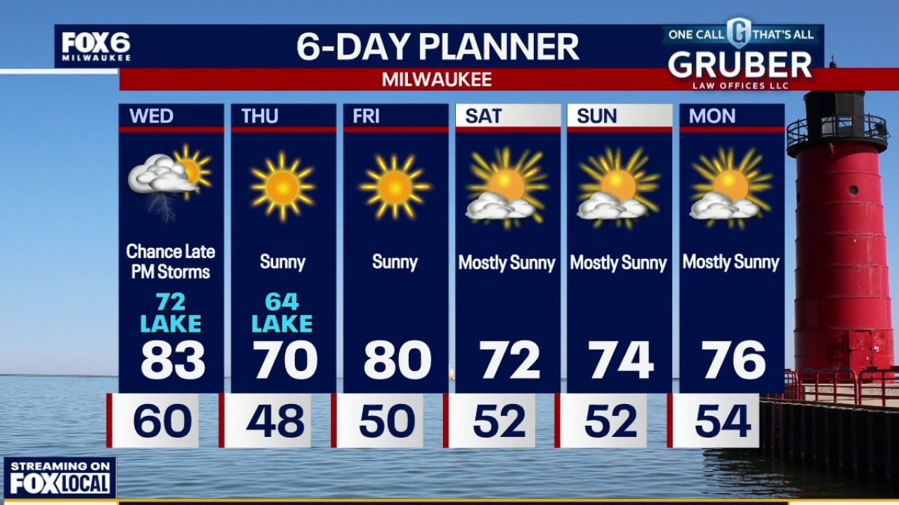
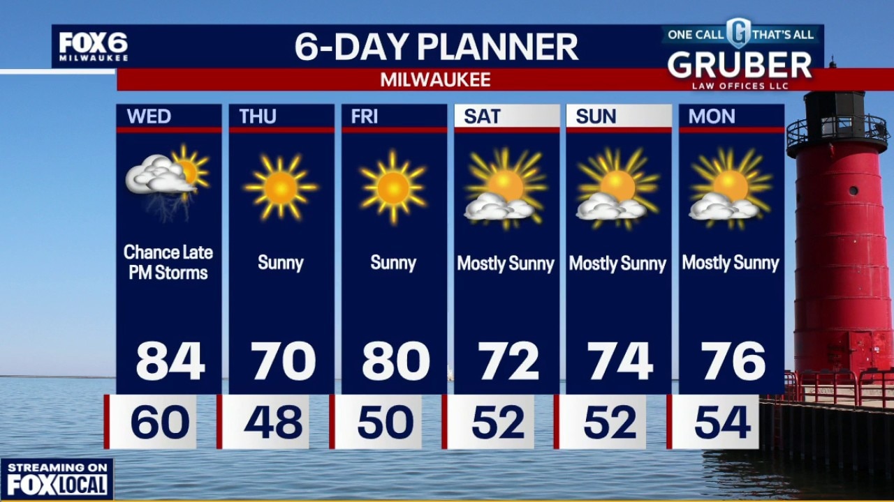
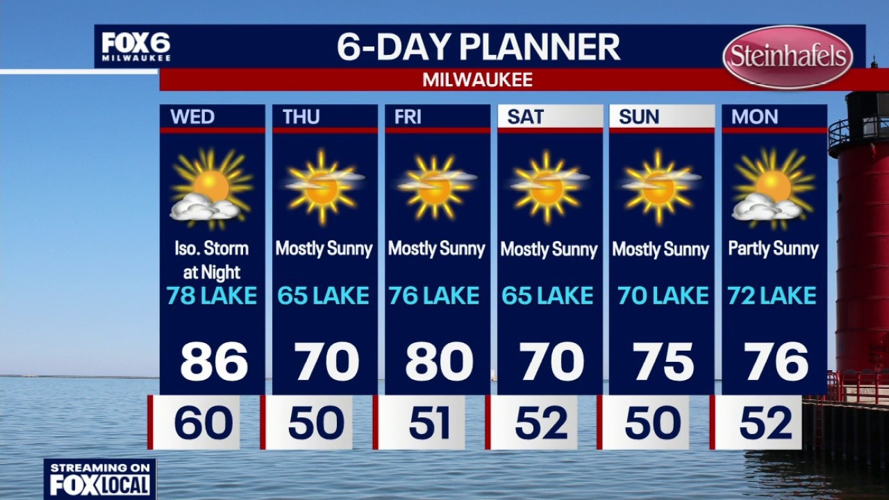
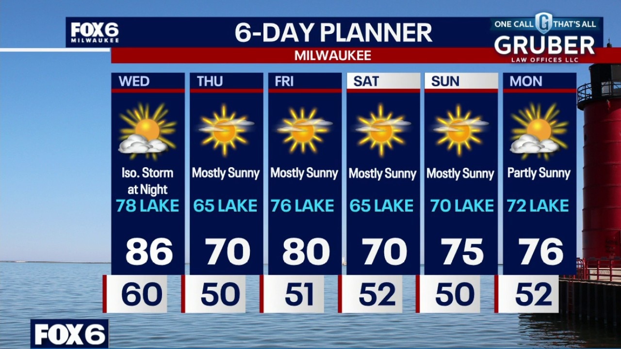
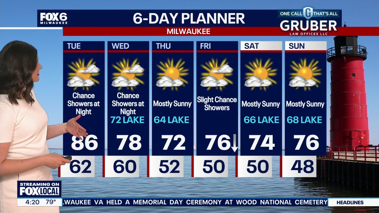
A backdoor cold front is set to shake things up across southern Wisconsin Wednesday, bringing a sharp temperature contrast from the lakeshore to inland areas.
A backdoor cold front is set to shake things up across southern Wisconsin Wednesday, bringing a sharp temperature contrast from the lakeshore to inland areas.
Weather webcast with Rob Haswell
A backdoor cold front is set to shake things up across southern Wisconsin Wednesday, bringing a sharp temperature contrast from the lakeshore to inland areas.
A backdoor cold front is set to shake things up across southern Wisconsin Wednesday, bringing a sharp temperature contrast from the lakeshore to inland areas.
Weather Webcast with Chief Meteorologist Tom Wachs
Partly cloudy and warm overnight. Temperatures dropping into the 60s. Partly sunny on Wednesday with a chance for an isolated t-storm at night. Highs in the mid-to-upper 80s inland, upper 70s near the lake. Cooler with sunshine on Thursday with a high around 70 inland, mid-60s near the lake. Warmer on Friday with sunny skies and highs the mid-70s near the lake, 80 inland.
Partly cloudy and warm overnight. Temperatures dropping into the 60s. Partly sunny on Wednesday with a chance for an isolated t-storm at night. Highs in the mid-to-upper 80s inland, upper 70s near the lake. Cooler with sunshine on Thursday with a high around 70 inland, mid-60s near the lake. Warmer on Friday with sunny skies and highs the mid-70s near the lake, 80 inland.
Weather Webcast with Chief Meteorologist Tom Wachs
Partly cloudy and warm tonight. Temperatures dropping into the 60s. Partly sunny on Wednesday with a chance for an isolated t-storm at night. Highs in the mid-to-upper 80s inland, upper 70s near the lake.
Partly cloudy and warm tonight. Temperatures dropping into the 60s. Partly sunny on Wednesday with a chance for an isolated t-storm at night. Highs in the mid-to-upper 80s inland, upper 70s near the lake.
Weather Webcast with Stephanie Barichello
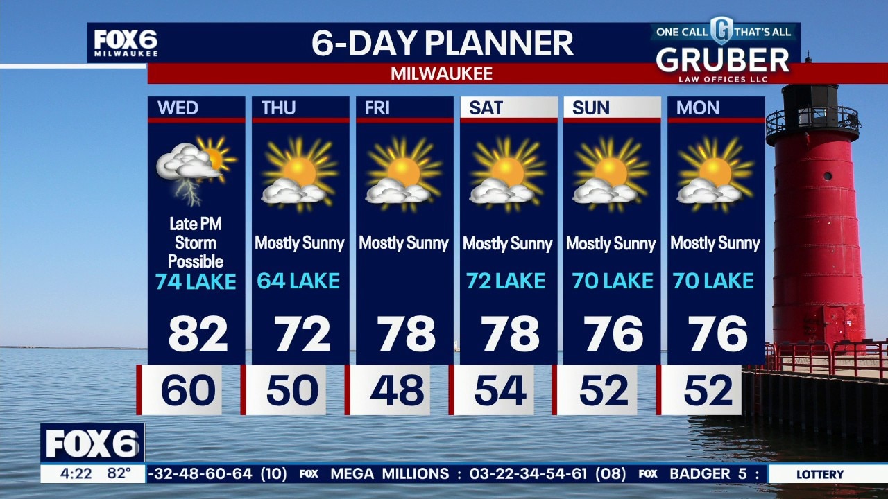
A wide range of temperatures on Wednesday thanks to an incoming cold front and lake breeze. There is a slight chance of showers or storms in the evening, then a long stretch of sunshine. Temperatures will mainly be in the 70s.
A wide range of temperatures on Wednesday thanks to an incoming cold front and lake breeze. There is a slight chance of showers or storms in the evening, then a long stretch of sunshine. Temperatures will mainly be in the 70s.
Weather webcast with Stephanie Barichello
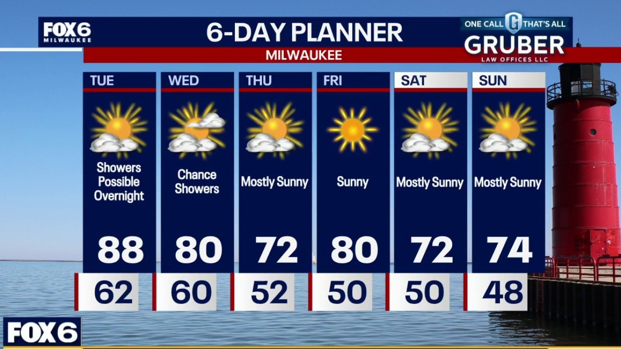
Summer warmth is settling into southern Wisconsin today with many inland spots pushing well into the 80s before a backdoor cold front slides south tonight into Wednesday.
Summer warmth is settling into southern Wisconsin today with many inland spots pushing well into the 80s before a backdoor cold front slides south tonight into Wednesday.
Weather webcast with Rob Haswell
Summer warmth is settling into southern Wisconsin today with many inland spots pushing well into the 80s before a backdoor cold front slides south tonight into Wednesday.
Summer warmth is settling into southern Wisconsin today with many inland spots pushing well into the 80s before a backdoor cold front slides south tonight into Wednesday.
Weather Webcast with Stephanie Barichello
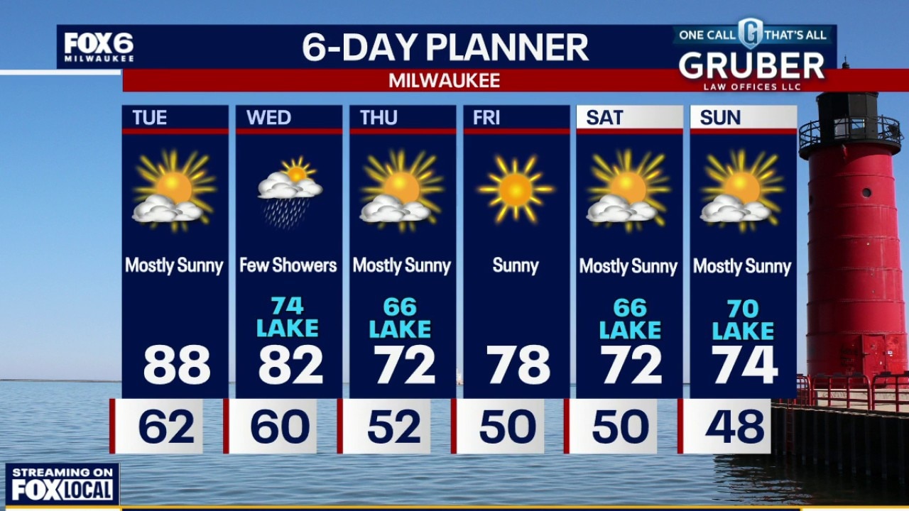
Another warm day ahead Tuesday, then slightly cooler the rest of the week. There is a slight chance of showers Tuesday and Wednesday night thanks to an incoming cold front, then again on Friday. Sadly, no major rain chances.
Another warm day ahead Tuesday, then slightly cooler the rest of the week. There is a slight chance of showers Tuesday and Wednesday night thanks to an incoming cold front, then again on Friday. Sadly, no major rain chances.
Weather webcast with Rob Haswell
Summer is giving us a sneak peek with highs climbing well into the 80s Monday through Wednesday, and a few well inland spots could touch 90 by Tuesday. Lakeshore areas will stay cooler at times thanks to afternoon lake breezes.
Summer is giving us a sneak peek with highs climbing well into the 80s Monday through Wednesday, and a few well inland spots could touch 90 by Tuesday. Lakeshore areas will stay cooler at times thanks to afternoon lake breezes.
Weather webcast with Rob Haswell
Summer is giving us a sneak peek with highs climbing well into the 80s Monday through Wednesday, and a few well inland spots could touch 90 by Tuesday.
Summer is giving us a sneak peek with highs climbing well into the 80s Monday through Wednesday, and a few well inland spots could touch 90 by Tuesday.
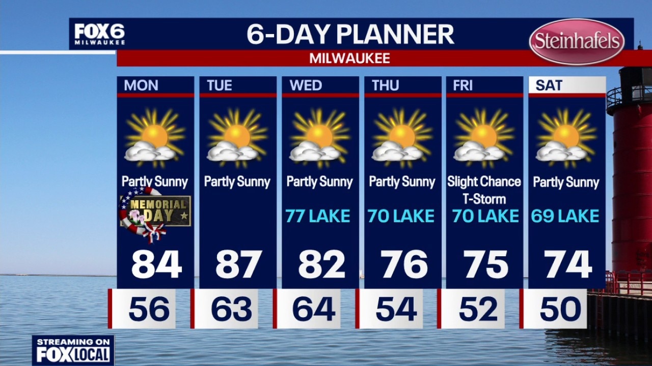
Weather Webcast with Chief Meteorologist Tom Wachs
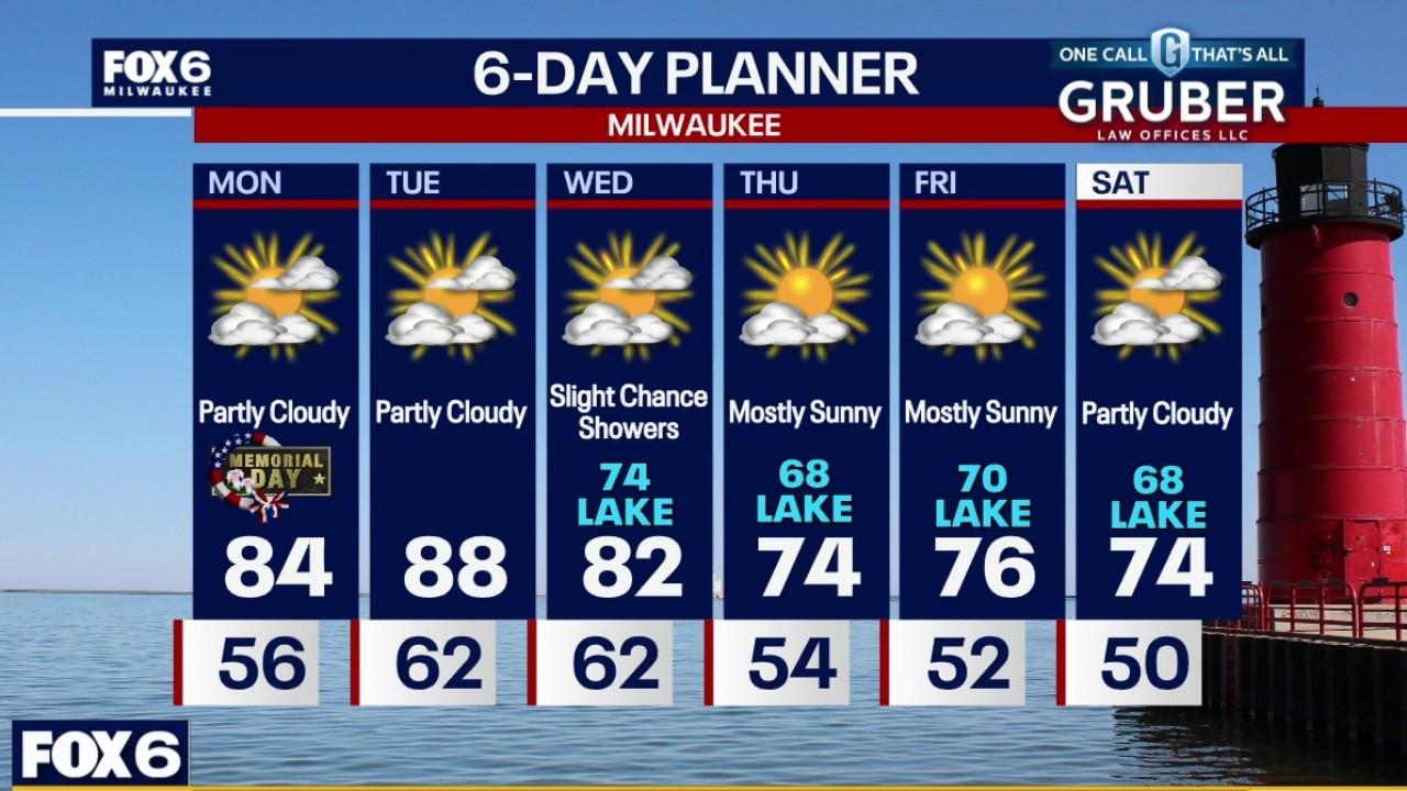
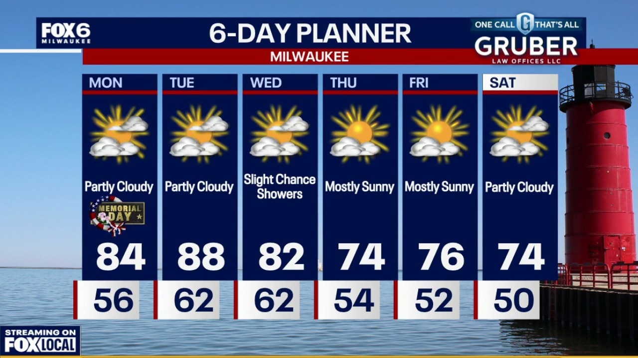
Quiet overnight with temperatures settling in the 50s. Showers and t-storms in Minnesota will fall apart before reaching us on Monday. We will get a few clouds from it. Warm and breezy on Memorial Day with highs in the mid-80s under partly sunny skies. Dew points in the mid-50s.
Quiet overnight with temperatures settling in the 50s. Showers and t-storms in Minnesota will fall apart before reaching us on Monday. We will get a few clouds from it. Warm and breezy on Memorial Day with highs in the mid-80s under partly sunny skies. Dew points in the mid-50s.
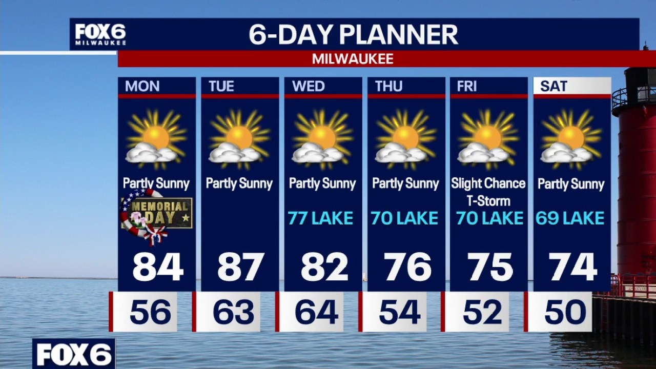
Weather Webcast with Chief Meteorologist Tom Wachs
Mostly clear tonight with temperatures dropping through the 60s and settling in the 50s overnight. T-Storms will develop around the Twin Cities tonight but they will fall apart before reaching us on Monday. We will get a few clouds from it. Warm and breezy on Memorial Day with highs in the mid-80s under partly sunny skies. Dew points in the mid-50s.
Mostly clear tonight with temperatures dropping through the 60s and settling in the 50s overnight. T-Storms will develop around the Twin Cities tonight but they will fall apart before reaching us on Monday. We will get a few clouds from it. Warm and breezy on Memorial Day with highs in the mid-80s under partly sunny skies. Dew points in the mid-50s.
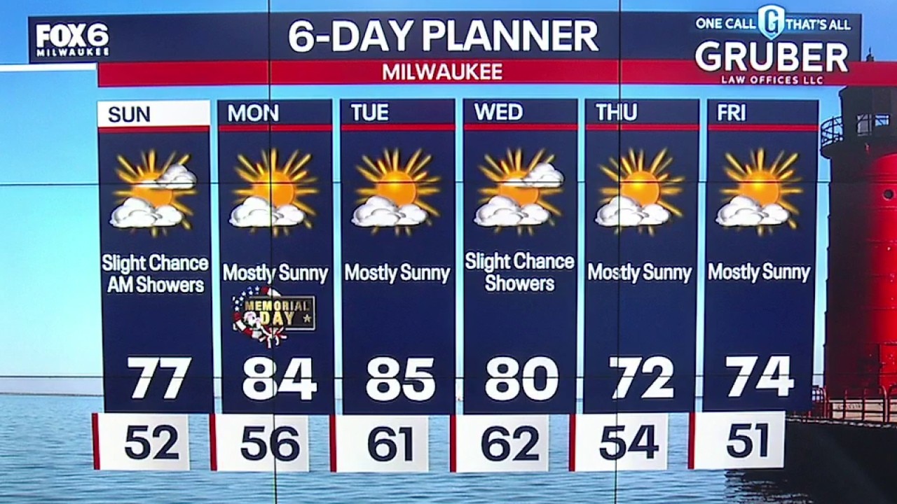
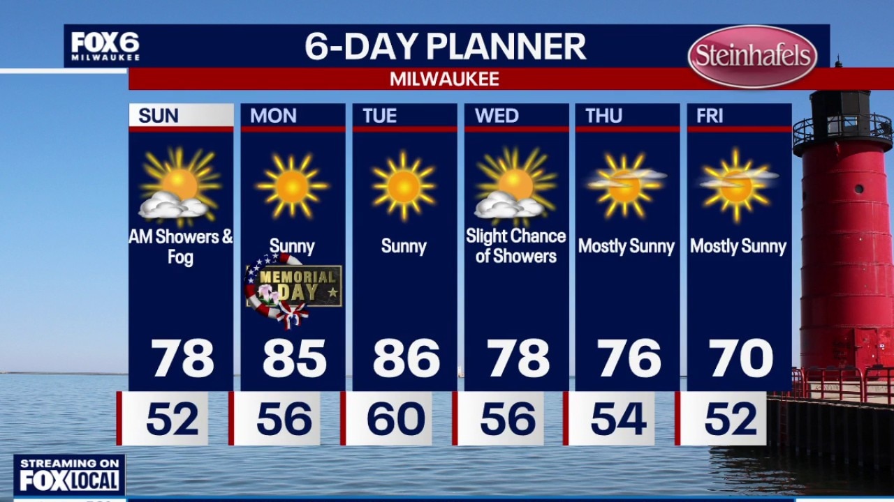
Weather webcast with Meteorologist Lisa Michaels
A chance for early morning showers with an isolated rumble of thunder. This will be clearing out by the afternoon with sunshine expected and temps in the middle 70s. Calm weather Sunday night heading into Memorial Day on Monday. Low temperatures in the middle 50s.
A chance for early morning showers with an isolated rumble of thunder. This will be clearing out by the afternoon with sunshine expected and temps in the middle 70s. Calm weather Sunday night heading into Memorial Day on Monday. Low temperatures in the middle 50s.
Weather Webcast with Holly Baker
Warmer temperatures are expected in the coming days.
Warmer temperatures are expected in the coming days.