


Weather webcast with Rob Haswell
Clear skies and dry air has allowed our area to cool into the teens and even some single digits well inland. Lots of sun today will help us rebound into the mid 30s by this afternoon. A few more clouds for tomorrow but a wind shift helps us warm into the upper 40s to near 50 and stay mild into Thursday. A low arrives late Wednesday into Thursday with rain likely. As we cool down Friday we will see a transition to light now.
Clear skies and dry air has allowed our area to cool into the teens and even some single digits well inland. Lots of sun today will help us rebound into the mid 30s by this afternoon. A few more clouds for tomorrow but a wind shift helps us warm into the upper 40s to near 50 and stay mild into Thursday. A low arrives late Wednesday into Thursday with rain likely. As we cool down Friday we will see a transition to light now.

Weather Webcast with Tom Wachs
Mostly clear and chilly overnight with temperatures falling into the teens. Tuesday morning will be the coldest of the month so far. Lots of sun on Tuesday with highs in the mid-30s.
Mostly clear and chilly overnight with temperatures falling into the teens. Tuesday morning will be the coldest of the month so far. Lots of sun on Tuesday with highs in the mid-30s.

Weather Webcast with Tom Wachs
Light snow showers and flurries will taper off this evening. Skies will clear out overnight with temperatures dropping into the teens overnight. The sun returns on Tuesday.
Light snow showers and flurries will taper off this evening. Skies will clear out overnight with temperatures dropping into the teens overnight. The sun returns on Tuesday.

Weather Webcast with Meteorologist Stephanie Barichello
Periods of sun and clouds today and some flurries at times. Sunshine returns Tuesday but it'll be a chilly day. Warmer with rain Thursday then some snow to start the weekend.
Periods of sun and clouds today and some flurries at times. Sunshine returns Tuesday but it'll be a chilly day. Warmer with rain Thursday then some snow to start the weekend.

Weather webcast with Rob Haswell
Winter Weather Advisory for Fond du Lac and Sheboygan counties until 7am Monday Light snow this morning as a low exits our area. Most areas will see an inch or less but our north counties will see more significant amounts. Highs today will be in the low 30s with overnight lows in the upper teens. Warmer air will slowly return later this week with a high near 50 possible by Thursday. Along with that warm up comes some rain for late week. We cool down again for the weekend.
Winter Weather Advisory for Fond du Lac and Sheboygan counties until 7am Monday Light snow this morning as a low exits our area. Most areas will see an inch or less but our north counties will see more significant amounts. Highs today will be in the low 30s with overnight lows in the upper teens. Warmer air will slowly return later this week with a high near 50 possible by Thursday. Along with that warm up comes some rain for late week. We cool down again for the weekend.

Weather Webcast with Tom Wachs
Snow will move through north to south overnight. A few inches of accumulation possible in Fond du Lac and Sheboygan counties, lesser south. A few slick spots possible in the morning.
Snow will move through north to south overnight. A few inches of accumulation possible in Fond du Lac and Sheboygan counties, lesser south. A few slick spots possible in the morning.

Weather Webcast with Meteorologist Lisa Michaels
Snow will continue through today and into Monday morning. For a majority of southeast Wisconsin this is looking like 1-3" of snow with higher totals for areas north that could see 3-6".
Snow will continue through today and into Monday morning. For a majority of southeast Wisconsin this is looking like 1-3" of snow with higher totals for areas north that could see 3-6".

Weather Webcast with Meteorologist Eric Manges
More snow through Monday morning with many areas having a decent chance at 2-4" and higher totals north
More snow through Monday morning with many areas having a decent chance at 2-4" and higher totals north

Weather Webcast with Meteorologist Eric Manges
1-3" of snow possible for areas South with areas North getting possibly 4-8" when it's all said and done Monday morning
1-3" of snow possible for areas South with areas North getting possibly 4-8" when it's all said and done Monday morning

Weather Webcast with Meteorologist Eric Manges
Snow moves in tonight and continues Sunday, 1-3" possible for most.
Snow moves in tonight and continues Sunday, 1-3" possible for most.
Weather Webcast with Meteorologist Eric Manges
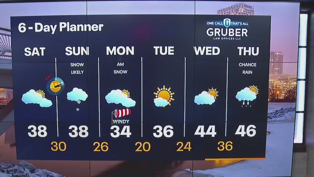
Mostly cloudy throughout the day then snow moves in overnight and continues through Sunday. For a majority of southeast Wisconsin, this is looking like 1-3" of snow with higher totals for areas north. Windy Monday but finally some clearing skies in Tuesday.
Mostly cloudy throughout the day then snow moves in overnight and continues through Sunday. For a majority of southeast Wisconsin, this is looking like 1-3" of snow with higher totals for areas north. Windy Monday but finally some clearing skies in Tuesday.
Weather Webcast with Meteorologist Eric Manges
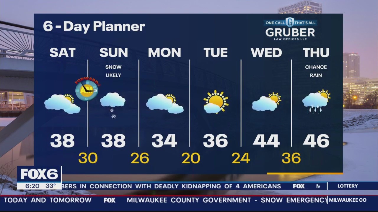
Biggest snow in 5 years for Milwaukee and a little more on the way Sunday
Biggest snow in 5 years for Milwaukee and a little more on the way Sunday
Weather Webcast with Meteorologist Stephanie Barichello
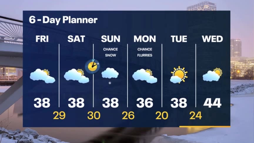
Much better this afternoon with temperatures in the mid to upper 30s, allowing for some melting. Refreeze is possible tonight as temperatures drop into the 20s then there is another round of snow on the way Sunday.
Much better this afternoon with temperatures in the mid to upper 30s, allowing for some melting. Refreeze is possible tonight as temperatures drop into the 20s then there is another round of snow on the way Sunday.

FOX6 WakeUp News at 4 (winter storm coverage)
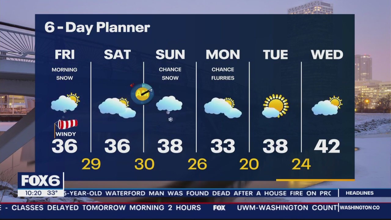
Winter Weather Advisory and Winter Storm Warning end today at 10am. Waking up to several inches of snow and we can expect another 1-3" before the last flake falls. Highs today will be in the mid to upper 30s and we should stay in that range through the weekend. Saturday will be a calmer day but light snow returns to the area on Sunday.
Winter Weather Advisory and Winter Storm Warning end today at 10am. Waking up to several inches of snow and we can expect another 1-3" before the last flake falls. Highs today will be in the mid to upper 30s and we should stay in that range through the weekend. Saturday will be a calmer day but light snow returns to the area on Sunday.
Weather Webcast with Meteorologist Eric Manges
Heavy snow through tonight giving much of the area 5-9"
Heavy snow through tonight giving much of the area 5-9"
Weather Webcast with Meteorologist Stephanie Barichello
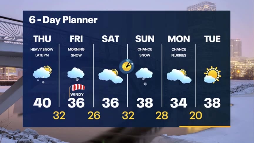
Snow arrives later this afternoon and evening and continues through midday Friday. 4-6" possible inland with 6-8" lakeside, IF there's lake enhancement. Plan on slow Friday morning commute.
Snow arrives later this afternoon and evening and continues through midday Friday. 4-6" possible inland with 6-8" lakeside, IF there's lake enhancement. Plan on slow Friday morning commute.
Weather webcast with Rob Haswell
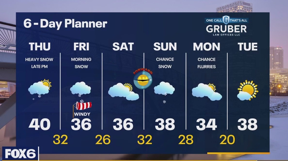
Winter Weather Advisory and Winter Storm Warning from 6pm Thursday to early Friday for all of our viewing area. Snow will start in the afternoon and evening and continue into the midday on Friday. Most areas will see around 4-6" worth of snow with some areas nearest to Lake Michigan in a 5-9" range. We start cloudy and mild buy only warm slightly to a high near 40. We cool into the mid to upper 30s Friday and through the weekend.
Winter Weather Advisory and Winter Storm Warning from 6pm Thursday to early Friday for all of our viewing area. Snow will start in the afternoon and evening and continue into the midday on Friday. Most areas will see around 4-6" worth of snow with some areas nearest to Lake Michigan in a 5-9" range. We start cloudy and mild buy only warm slightly to a high near 40. We cool into the mid to upper 30s Friday and through the weekend.

Weather Webcast with Tom Wachs
Winter Weather Advisory Thursday Night. Snow moves in late Thursday afternoon and really picks up Thursday night into Friday morning. 4-8" expected.
Winter Weather Advisory Thursday Night. Snow moves in late Thursday afternoon and really picks up Thursday night into Friday morning. 4-8" expected.
Weather Webcast with Tom Wachs
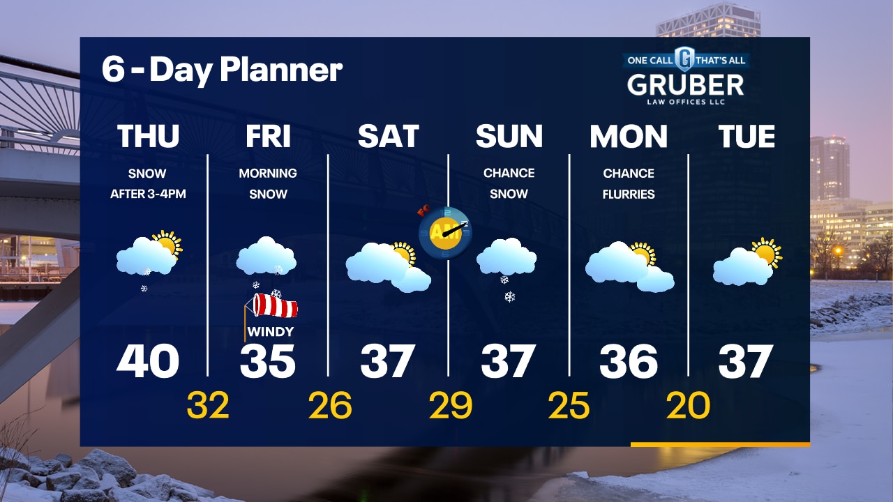
Increasing clouds tonight with temperatures in the 30s. Snow moves in late in the day into the evening Thursday. It will really pick up Thursday night into Friday morning. 4-8" expected.
Increasing clouds tonight with temperatures in the 30s. Snow moves in late in the day into the evening Thursday. It will really pick up Thursday night into Friday morning. 4-8" expected.
Weather Webcast with Meteorologist Stephanie Barichello
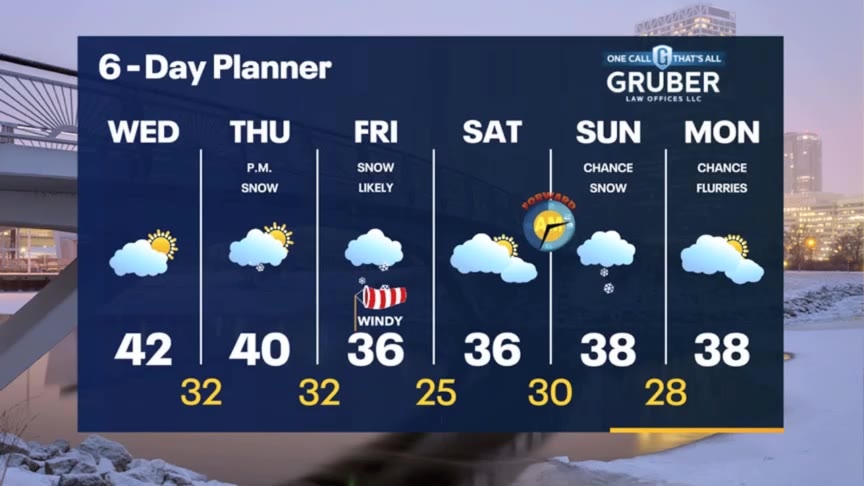
Quiet today then snow arrives Thursday afternoon, lasting through Friday morning. 4-8" of snowfall possible in most spots. Drying out Saturday then more light snow Sunday.
Quiet today then snow arrives Thursday afternoon, lasting through Friday morning. 4-8" of snowfall possible in most spots. Drying out Saturday then more light snow Sunday.