

Weather Webcast with Tom Wachs
Watch out for icy patches overnight. The water from the rain earlier will freeze overnight as temperatures drop.
Watch out for icy patches overnight. The water from the rain earlier will freeze overnight as temperatures drop.
Weather Webcast with Tom Wachs
A powerful cold front will be rolling through tonight. Showers and a few t-storms are possible this evening. It will be windy. Temperatures in the 20s by morning with wind chills in the single digits/teens.
A powerful cold front will be rolling through tonight. Showers and a few t-storms are possible this evening. It will be windy. Temperatures in the 20s by morning with wind chills in the single digits/teens.
Weather Webcast with Meteorologist Stephanie Barichello
Scattered rain showers this afternoon plus windy and mild in the 50s. Rain wraps up around midnight then the wind picks up even more Wednesday. Temperatures will be in the 20s much of the day with wind chills in the teens.
Scattered rain showers this afternoon plus windy and mild in the 50s. Rain wraps up around midnight then the wind picks up even more Wednesday. Temperatures will be in the 20s much of the day with wind chills in the teens.
Weather webcast with Lisa Michaels
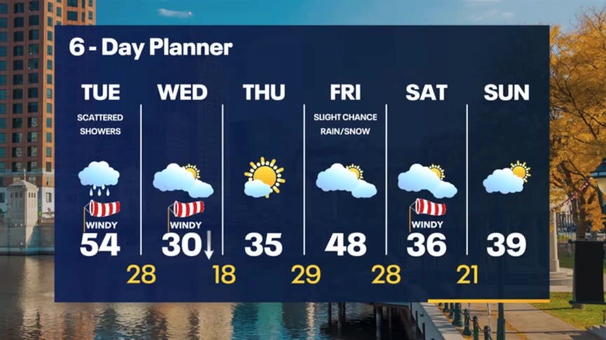
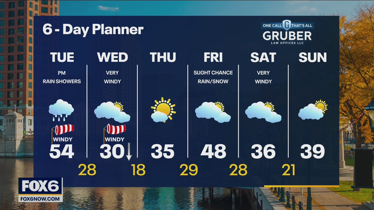
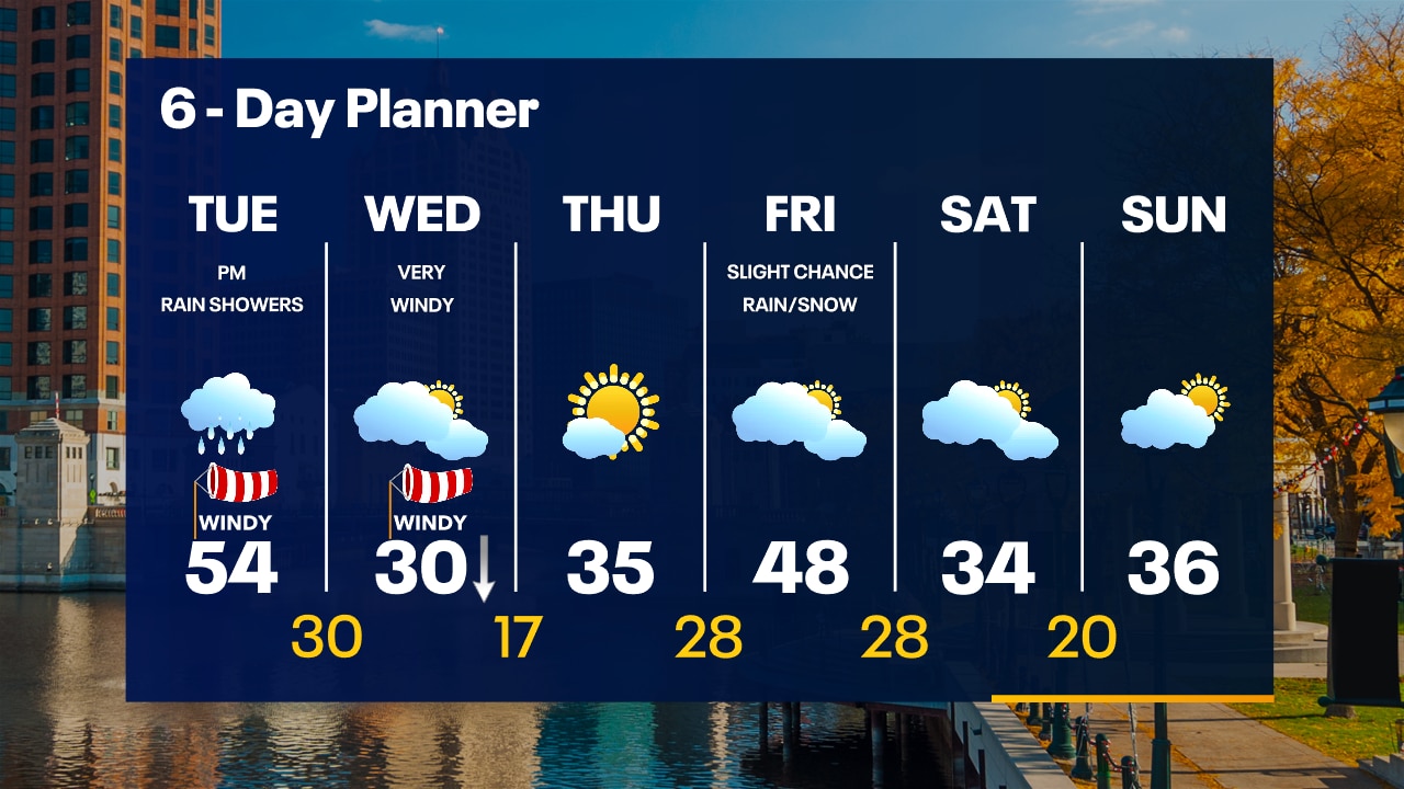
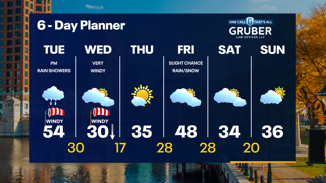
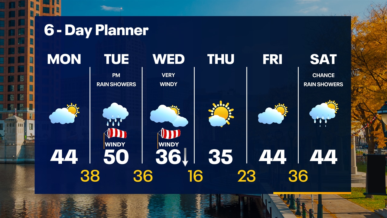
Cloudy Tuesday with dry conditions for most of the day. Rain chances increase this afternoon and tonight with the passing of a cold front. Highs in the upper 40s to lower 50s. Very windy conditions today with gusts up to 40mph. Strong winds will stay through Wednesday. Very windy on Wednesday and cold. Temperatures falling into the 20s later in the day with wind gusts over 40mph.
Cloudy Tuesday with dry conditions for most of the day. Rain chances increase this afternoon and tonight with the passing of a cold front. Highs in the upper 40s to lower 50s. Very windy conditions today with gusts up to 40mph. Strong winds will stay through Wednesday. Very windy on Wednesday and cold. Temperatures falling into the 20s later in the day with wind gusts over 40mph.
Weather Webcast with Tom Wachs
Mostly cloudy overnight with temperatures in the mid-30s to around 40 by sunrise. The wind will pick up on Tuesday with a chance for afternoon/evening rain showers. Highs in the 50s.
Mostly cloudy overnight with temperatures in the mid-30s to around 40 by sunrise. The wind will pick up on Tuesday with a chance for afternoon/evening rain showers. Highs in the 50s.
Weather Webcast with Tom Wachs
Mostly cloudy tonight with steady temperatures in the upper 30s to low 40s. Rain moves in Tuesday afternoon with highs in the 50s. Very windy and chilly on Wednesday.
Mostly cloudy tonight with steady temperatures in the upper 30s to low 40s. Rain moves in Tuesday afternoon with highs in the 50s. Very windy and chilly on Wednesday.
Weather Webcast with Meteorologist Stephanie Barichello
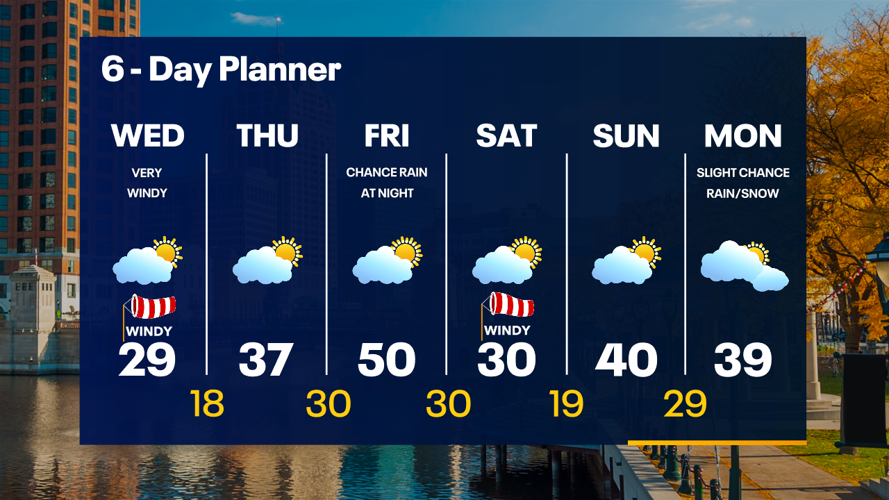
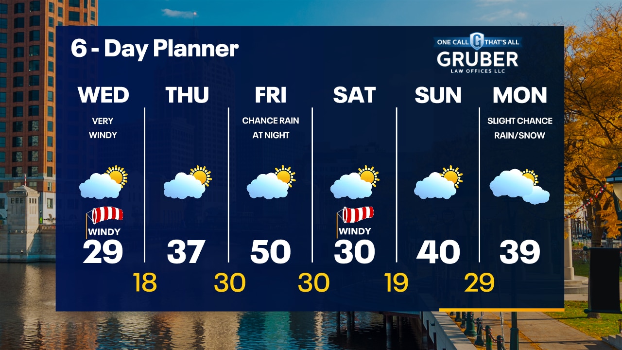
Quiet today then a few rain showers will be possible later Tuesday. It may change to light snow briefly early Wednesday, otherwise expect a very windy and cold day with highs in the 30s and wind chills in the teens.
Quiet today then a few rain showers will be possible later Tuesday. It may change to light snow briefly early Wednesday, otherwise expect a very windy and cold day with highs in the 30s and wind chills in the teens.
Weather webcast with Rob Haswell
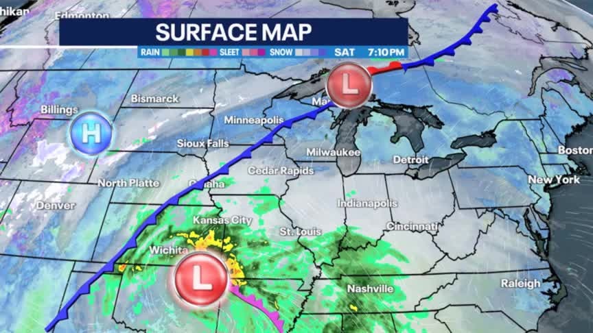
A cold front sits to our west with a developing low farther south along that front. Ahead of all of that today we see a steady southerly wind and increasing amounts of moisture. That increased moisture at the surface level is condensing into fog in some areas and a few spots may be dense. Take care on area roads this morning - particularly in areas that are at or below freezing.
A cold front sits to our west with a developing low farther south along that front. Ahead of all of that today we see a steady southerly wind and increasing amounts of moisture. That increased moisture at the surface level is condensing into fog in some areas and a few spots may be dense. Take care on area roads this morning - particularly in areas that are at or below freezing.

Weather Webcast with Tom Wachs
Watch out for refreeze overnight with water from the rain earlier freezing on sidewalks, driveways and parking lots. Increasing clouds on Monday with highs in the 40s.
Watch out for refreeze overnight with water from the rain earlier freezing on sidewalks, driveways and parking lots. Increasing clouds on Monday with highs in the 40s.
Weather Webcast with Tom Wachs
Clearing skies tonight with temperatures dropping through the 30s and into the 20s overnight. Increasing clouds on Monday with highs in the middle 40s. Rain chances return Tuesday afternoon.
Clearing skies tonight with temperatures dropping through the 30s and into the 20s overnight. Increasing clouds on Monday with highs in the middle 40s. Rain chances return Tuesday afternoon.

Weather webcast with Lisa Michaels
Cloudy with chances of showers especially further southeast. Breezy winds stick around this afternoon with gusts up to 30 mph.
Cloudy with chances of showers especially further southeast. Breezy winds stick around this afternoon with gusts up to 30 mph.
Weather Webcast with Meteorologist Eric Manges
Rain moves in tonight and so does cooler air long term
Rain moves in tonight and so does cooler air long term
Weather Webcast with Meteorologist Lisa Michaels
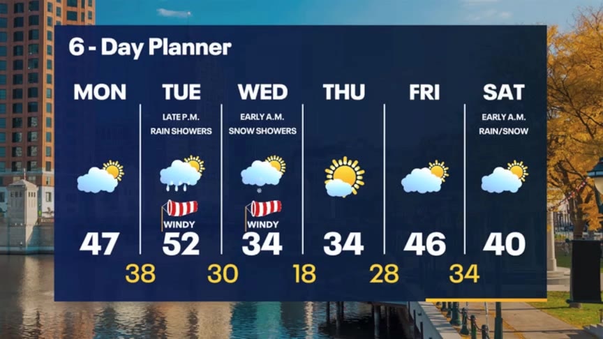
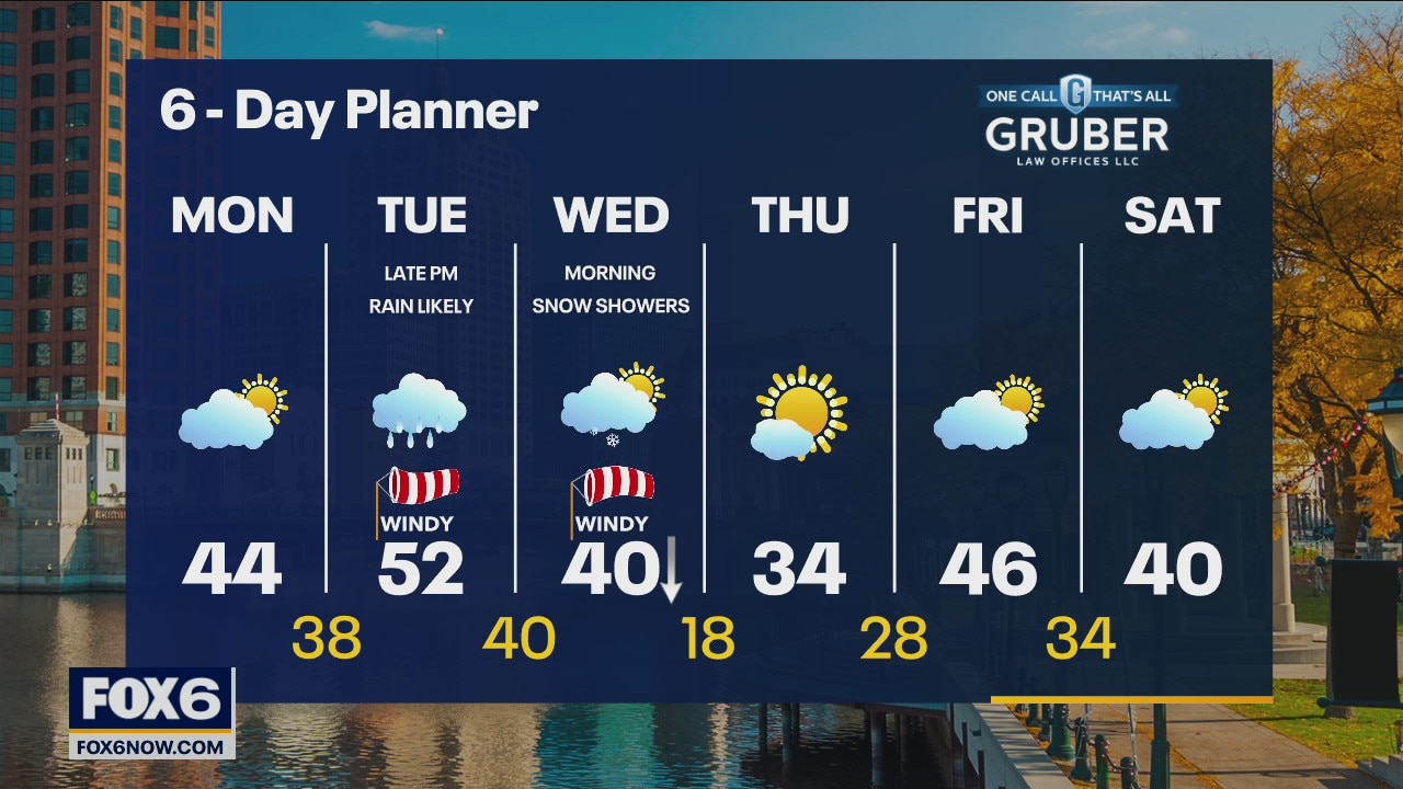
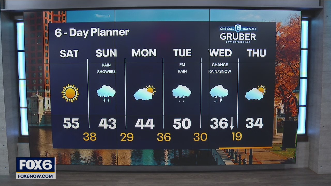
Above average temperatures and sunshine stick around Saturday! Clouds will increase Saturday night with the chance of rain by Sunday. Cooler temperatures begin to move in next week, especially by the end of the week with highs back in the 30s. Rain is likely to move in late Tuesday followed by a mix of rain/snow on Wednesday.
Above average temperatures and sunshine stick around Saturday! Clouds will increase Saturday night with the chance of rain by Sunday. Cooler temperatures begin to move in next week, especially by the end of the week with highs back in the 30s. Rain is likely to move in late Tuesday followed by a mix of rain/snow on Wednesday.
Weather Webcast with Meteorologist Eric Manges
Looking nice for Saturday but rain returns Sunday and we get cooler next week.
Looking nice for Saturday but rain returns Sunday and we get cooler next week.
Weather Webcast with Chief Meteorologist Rob Haswell
A broad ridge of high pressure moves over our area for the next couple of day, keeping us clear and mild. Highs today will be near 50 and warm into the mid to upper 50s tomorrow. Sunday looks wet with rain likely and a chance for snow to mix into some areas at times. More rain arrives later Tuesday.
A broad ridge of high pressure moves over our area for the next couple of day, keeping us clear and mild. Highs today will be near 50 and warm into the mid to upper 50s tomorrow. Sunday looks wet with rain likely and a chance for snow to mix into some areas at times. More rain arrives later Tuesday.
Weather Webcast with Meteorologist Stephanie Barichello
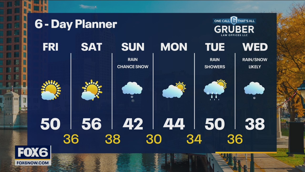
Clearing clouds Friday morning with plenty of sunshine through Saturday, plus warmer! Rain and some snow likely on Sunday then a bigger system will bring rain changing to snow Tuesday into Wednesday.
Clearing clouds Friday morning with plenty of sunshine through Saturday, plus warmer! Rain and some snow likely on Sunday then a bigger system will bring rain changing to snow Tuesday into Wednesday.
Weather webcast with Rob Haswell
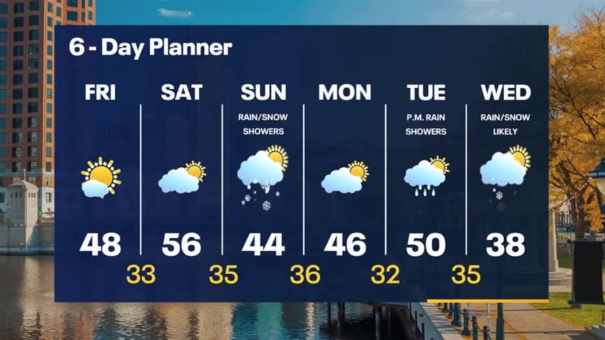
Ahead of cold front today we will be mild with highs well into the 50s again. However, with more moisture comes more clouds, some patchy fog and a few showers. Behind the cold front we cool but remain above average with highs in the upper 40s to near 50 and lots of sunshine for Friday. Saturday will be another very mild day with highs well into the 50s but we drop into the low 40s Sunday with a chance for rain and snow showers.
Ahead of cold front today we will be mild with highs well into the 50s again. However, with more moisture comes more clouds, some patchy fog and a few showers. Behind the cold front we cool but remain above average with highs in the upper 40s to near 50 and lots of sunshine for Friday. Saturday will be another very mild day with highs well into the 50s but we drop into the low 40s Sunday with a chance for rain and snow showers.
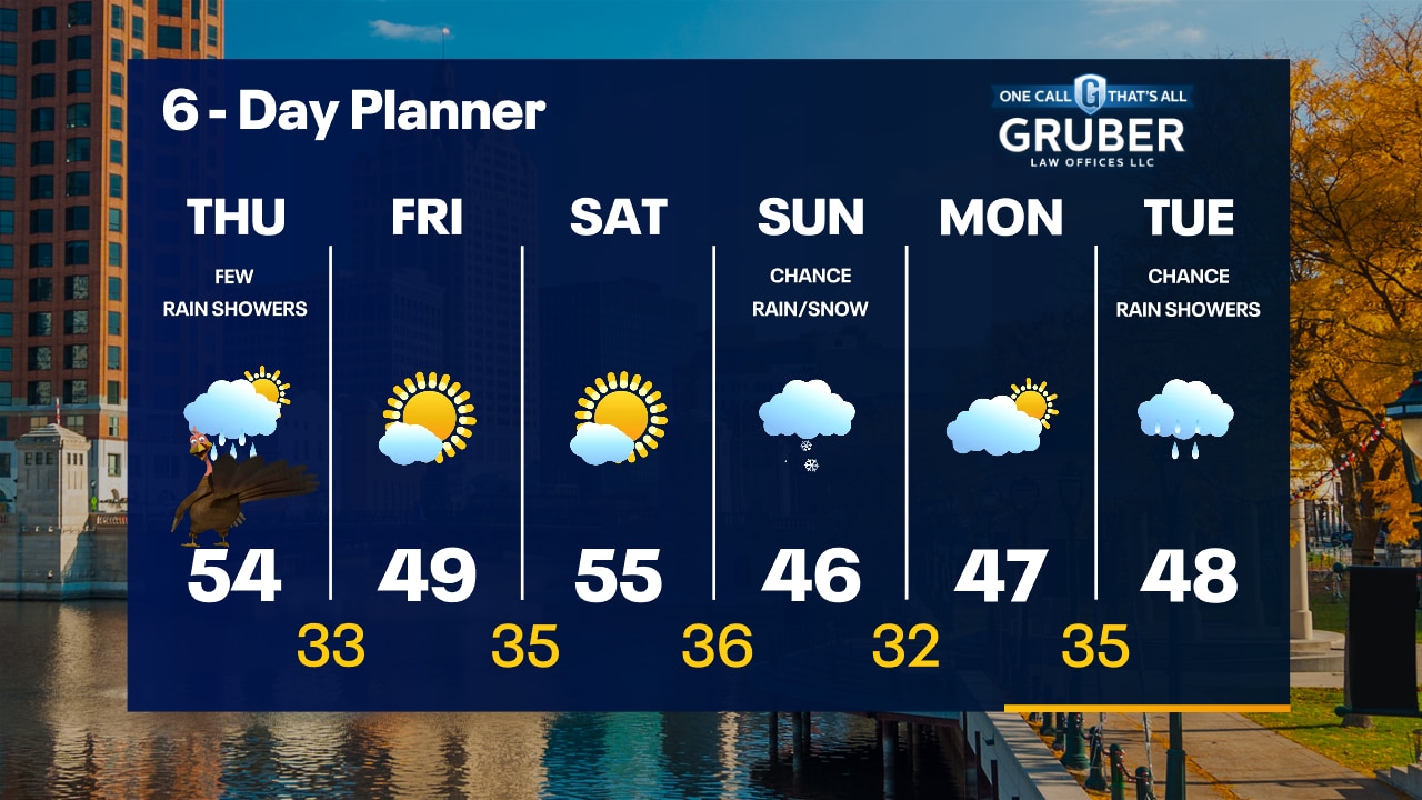
Weather Webcast with Tom Wachs
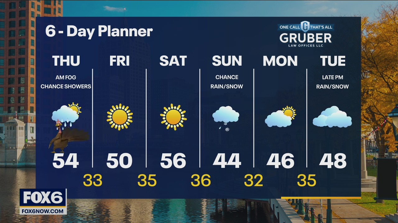
Increasing clouds overnight with temperatures in the 30s to around 40. Mostly cloudy with spotty light rain showers on Thanksgiving and highs in the low-to-mid 50s.
Increasing clouds overnight with temperatures in the 30s to around 40. Mostly cloudy with spotty light rain showers on Thanksgiving and highs in the low-to-mid 50s.
Weather Webcast with Tom Wachs
Increasing clouds tonight with temperatures in the 30s and 40s. Mostly cloudy with spotty light rain showers on Thanksgiving with highs in the low-to-mid 50s.
Increasing clouds tonight with temperatures in the 30s and 40s. Mostly cloudy with spotty light rain showers on Thanksgiving with highs in the low-to-mid 50s.
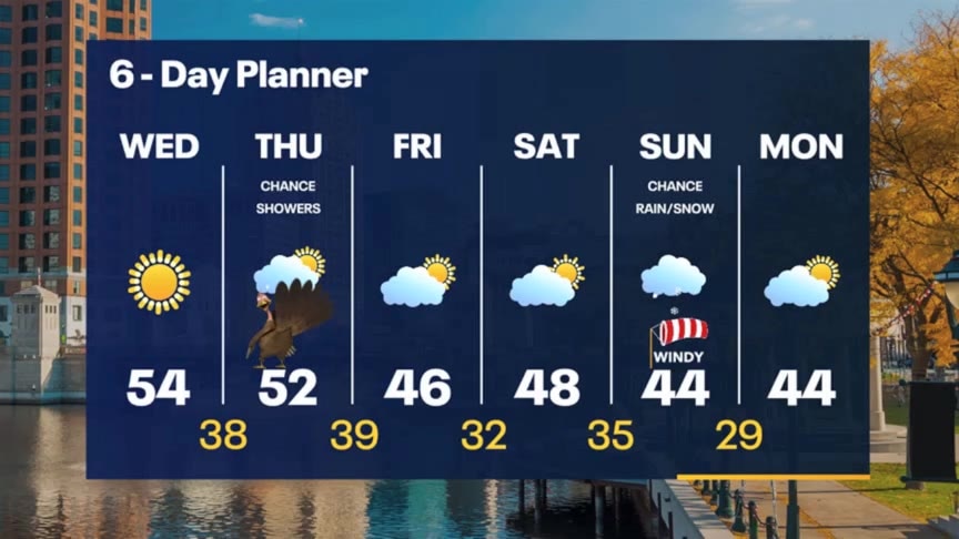
Weather Webcast with Meteorologist Stephanie Barichello
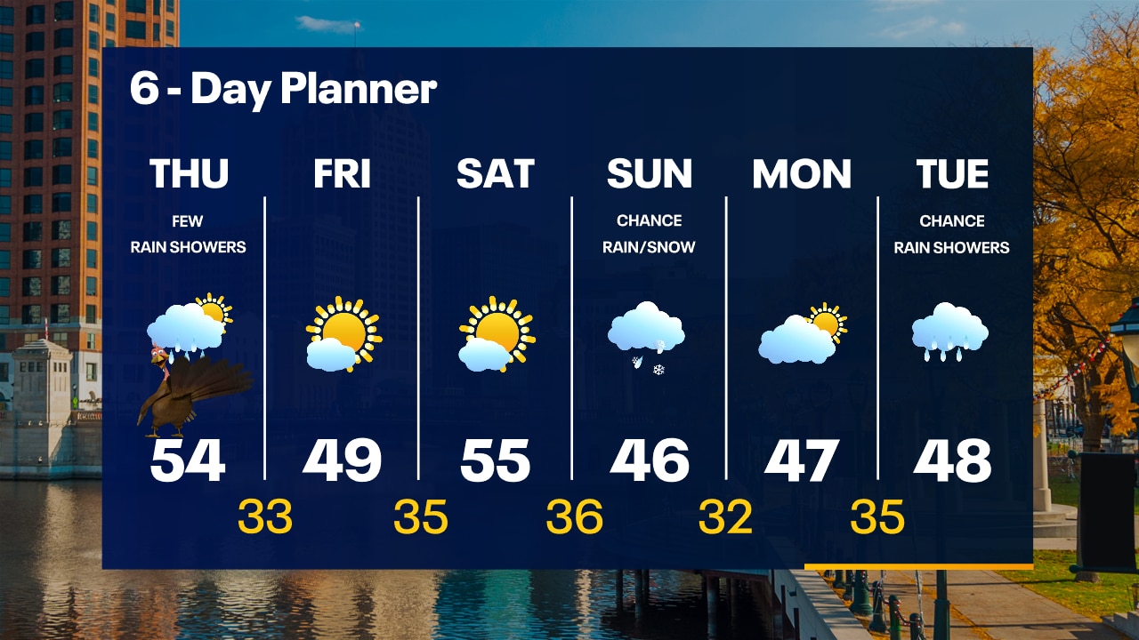
Sunny and beautiful today then a few light rain showers on Thanksgiving. Cooler to end the week and over the weekend. Could have some rain and wintry mix on Sunday.
Sunny and beautiful today then a few light rain showers on Thanksgiving. Cooler to end the week and over the weekend. Could have some rain and wintry mix on Sunday.