


Weather Webcast with Tom Wachs
Mostly clear tonight with temperatures dropping into the 60s later this evening. Partly sunny and warm on Wednesday with highs in the 80s. A few isolated afternoon/evening t-storms are possible.
Mostly clear tonight with temperatures dropping into the 60s later this evening. Partly sunny and warm on Wednesday with highs in the 80s. A few isolated afternoon/evening t-storms are possible.
Weather Webcast with Meteorologist Eric Manges
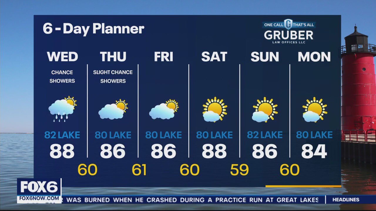
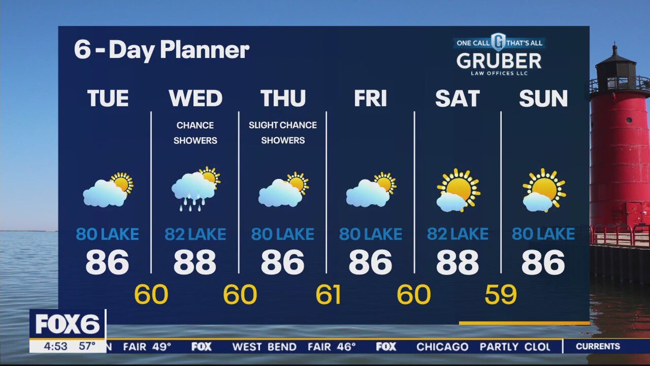
A chance of showers Wednesday afternoon and a slight chance Thursday and we need as much as we can get
A chance of showers Wednesday afternoon and a slight chance Thursday and we need as much as we can get

Weather Webcast with Meteorologist Eric Manges
Very warm through the week with some slight chances of rain finally
Very warm through the week with some slight chances of rain finally
Weather webcast with Rob Haswell
Yet another warm, dry day with highs warming into the mid to upper 80s inland and near 80 even lakeside.
Yet another warm, dry day with highs warming into the mid to upper 80s inland and near 80 even lakeside.
Weather Webcast with Rob Haswell
High pressure is keeping us sunny and helping us warm up again today. Highs will be in the low 80s inland and mid 70s lakeside with a breeze off of Lake Michigan. Due to warm temperatures, low humidity and a build up of pollutants, our inland counties have an Air Quality Alert for today.
High pressure is keeping us sunny and helping us warm up again today. Highs will be in the low 80s inland and mid 70s lakeside with a breeze off of Lake Michigan. Due to warm temperatures, low humidity and a build up of pollutants, our inland counties have an Air Quality Alert for today.
Weather Webcast with Tom Wachs
An Air Quality Alert is in effect for inland counties on Monday. Mostly sunny and beautiful with highs in the 80s inland, 70s near the lake.
An Air Quality Alert is in effect for inland counties on Monday. Mostly sunny and beautiful with highs in the 80s inland, 70s near the lake.

Weather Webcast with Tom Wachs
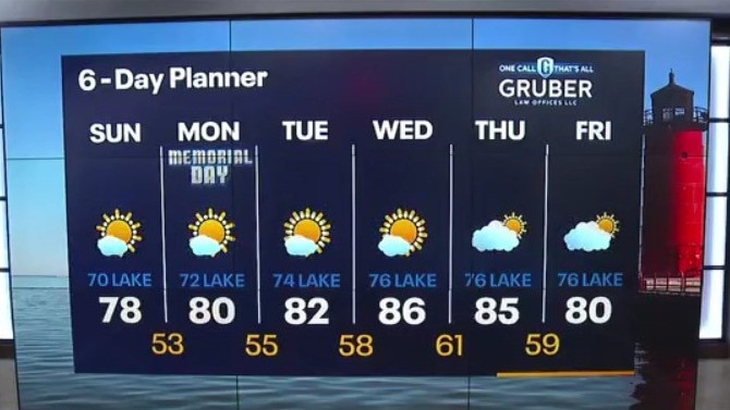
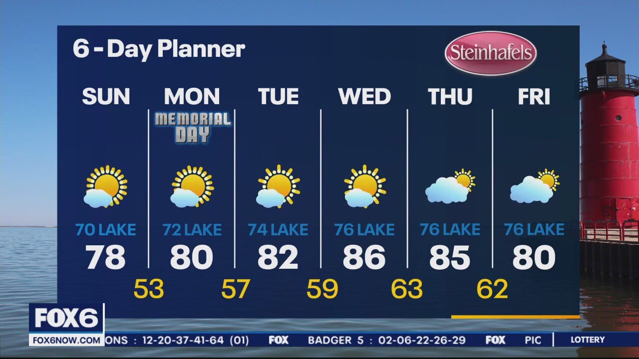
Clear skies tonight with temperatures falling into the 50s. Mostly sunny on Memorial Day with highs in the 80s Waukesha and west, 70s near the lake.
Clear skies tonight with temperatures falling into the 50s. Mostly sunny on Memorial Day with highs in the 80s Waukesha and west, 70s near the lake.
Weather Webcast with Meteorologist Lisa Michaels
Staying fantastic and sunny into Sunday and Monday with highs getting near 80. High temps continue to climb into the mid-80s next week.
Staying fantastic and sunny into Sunday and Monday with highs getting near 80. High temps continue to climb into the mid-80s next week.
Weather Webcast with Meteorologist Eric Manges
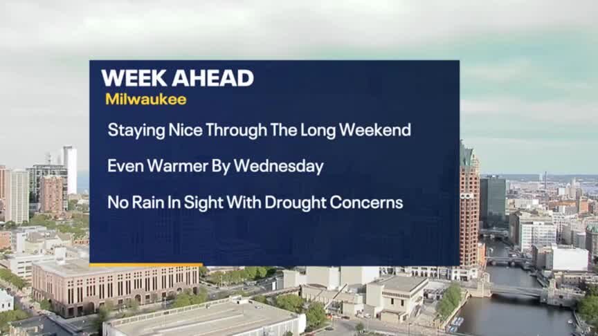
Dry weather continues as drought concerns grow but there are still some positive things going on
Dry weather continues as drought concerns grow but there are still some positive things going on
Weather Webcast with Meteorologist Eric Manges
Still no rain in the forecast but plenty of sunshine and warm temperatures.
Still no rain in the forecast but plenty of sunshine and warm temperatures.
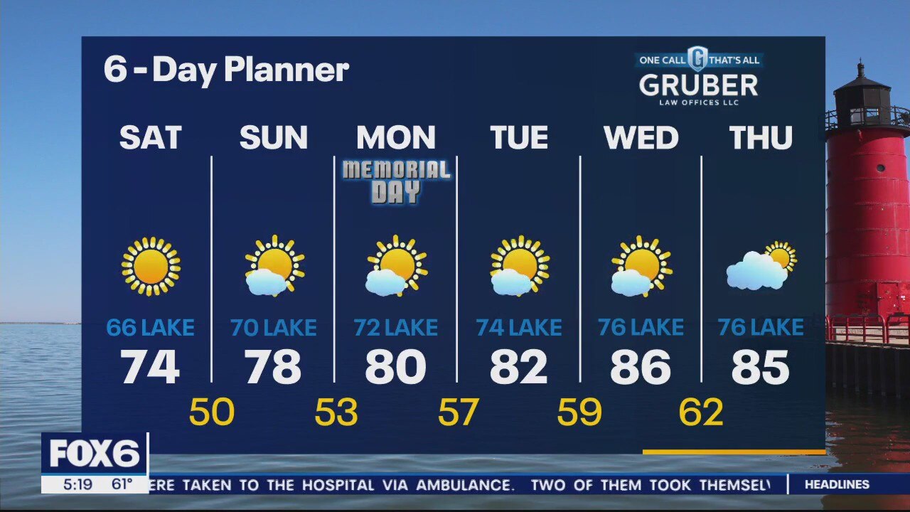
Weather Webcast with Meteorologist Lisa Michaels
Memorial Day Weekend will be mostly sunny and warming up each day. Temperatures will start in the mid 70s and warm into the low 80s by Monday.
Memorial Day Weekend will be mostly sunny and warming up each day. Temperatures will start in the mid 70s and warm into the low 80s by Monday.
Weather Webcast with Meteorologist Eric Manges
Temperatures continue to climb and climb as drought concerns also grow
Temperatures continue to climb and climb as drought concerns also grow

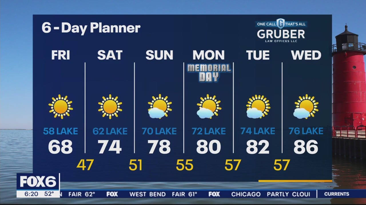
Weather Webcast With Lisa Michaels
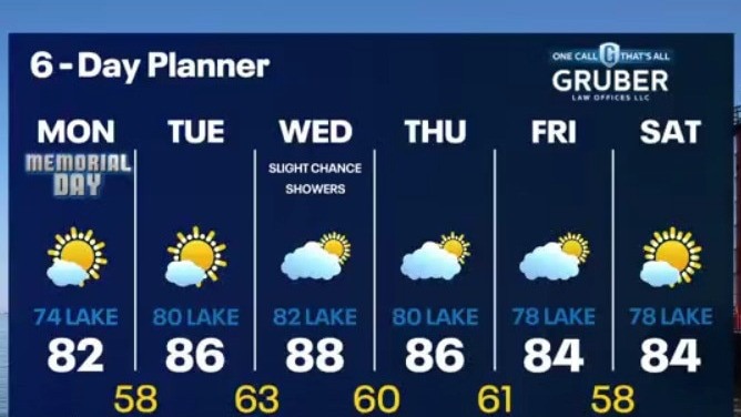
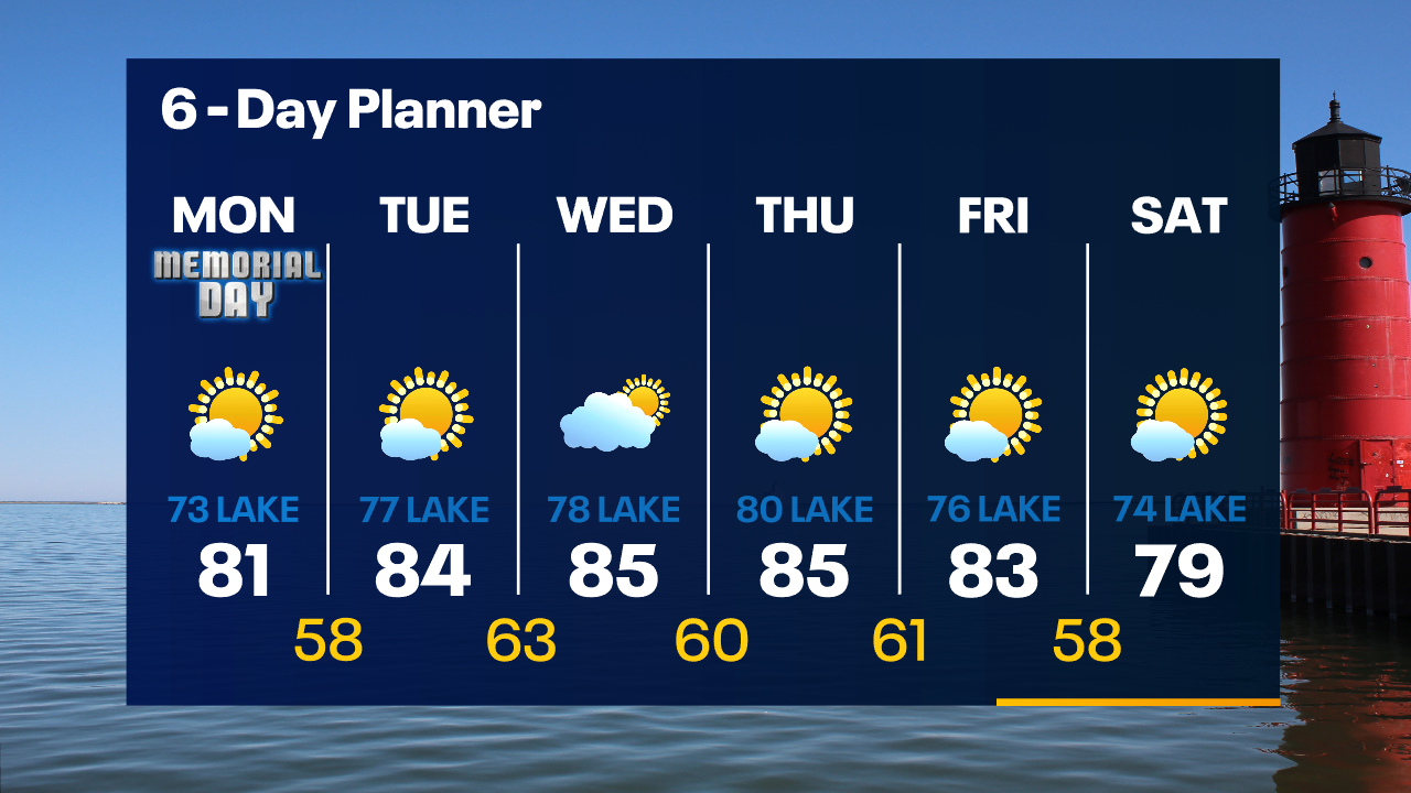
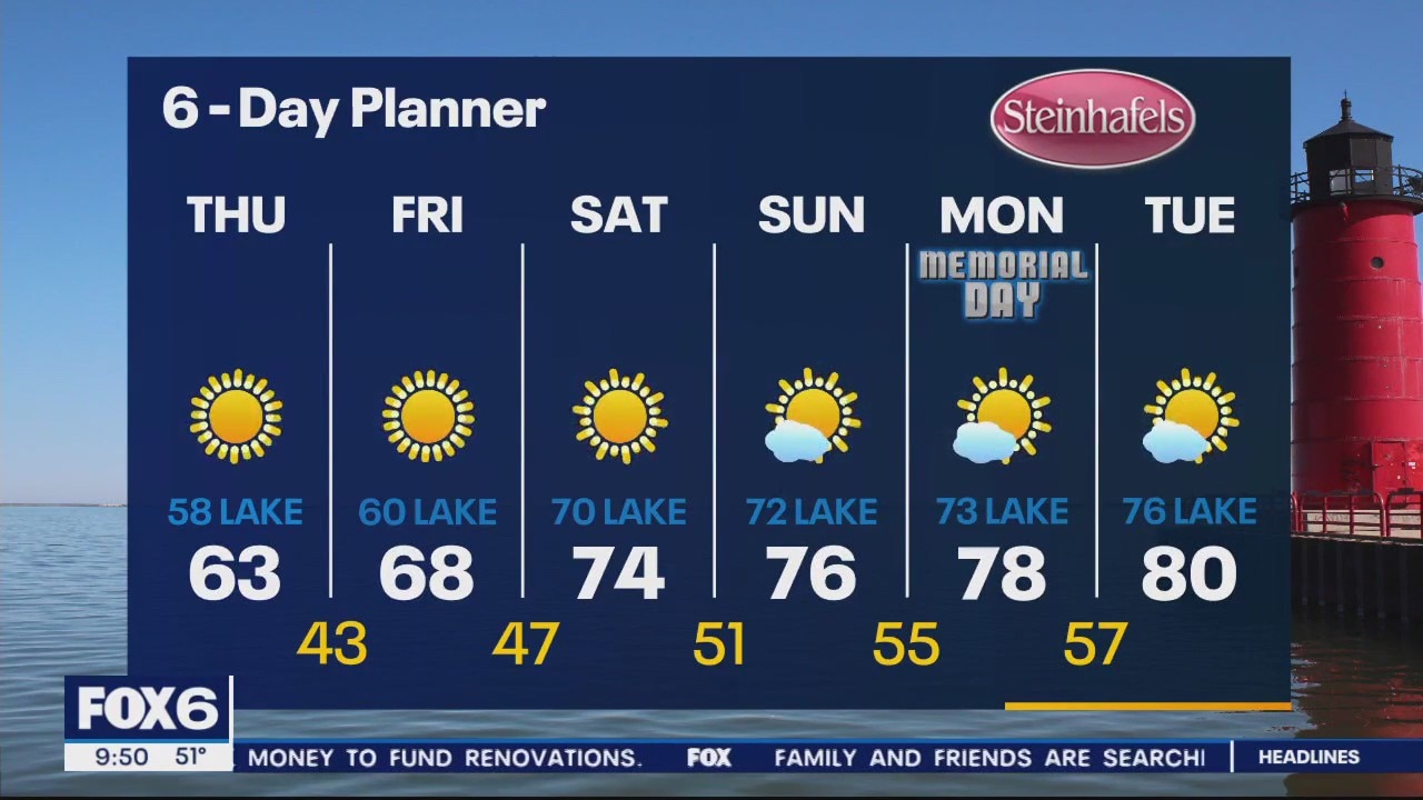
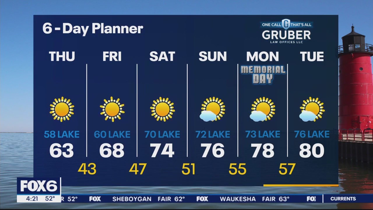
A blocking pattern in the upper atmosphere has us locked into a long stretch of sunny and dry weather. We begin a long warming trend today with highs near 70 inland and 60s lakeside. Warming up each day this weekend. Low to mid 70s Saturday. Mid to upper 70s Sunday. Upper 70s to low 80s Monday. We stay dry for the next several days. Concern for drought will grow in the days ahead.
A blocking pattern in the upper atmosphere has us locked into a long stretch of sunny and dry weather. We begin a long warming trend today with highs near 70 inland and 60s lakeside. Warming up each day this weekend. Low to mid 70s Saturday. Mid to upper 70s Sunday. Upper 70s to low 80s Monday. We stay dry for the next several days. Concern for drought will grow in the days ahead.
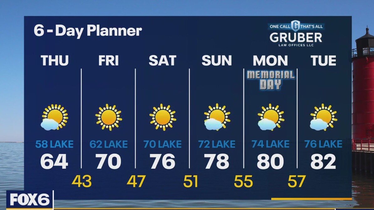
Weather webcast with Rob Haswell
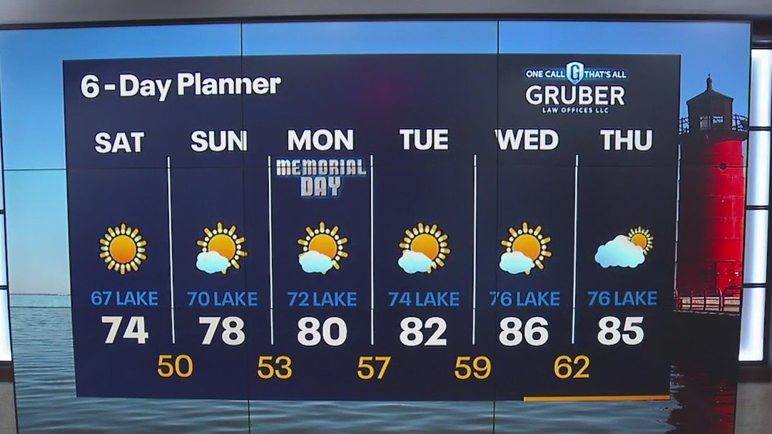
A blocking pattern in the upper atmosphere has us locked into a long stretch of sunny and dry weather. We begin a long warming trend today with highs near 70 inland and 60s lakeside. Highs climb into the mid-80s by Wednesday and look to hold for the long term. We stay dry for the next several days. Concern for drought will grow in the days ahead.
A blocking pattern in the upper atmosphere has us locked into a long stretch of sunny and dry weather. We begin a long warming trend today with highs near 70 inland and 60s lakeside. Highs climb into the mid-80s by Wednesday and look to hold for the long term. We stay dry for the next several days. Concern for drought will grow in the days ahead.
Weather Webcast with Meteorologist Eric Manges
Temps continue to climb into the weekend with sunshine but no rain in sight
Temps continue to climb into the weekend with sunshine but no rain in sight
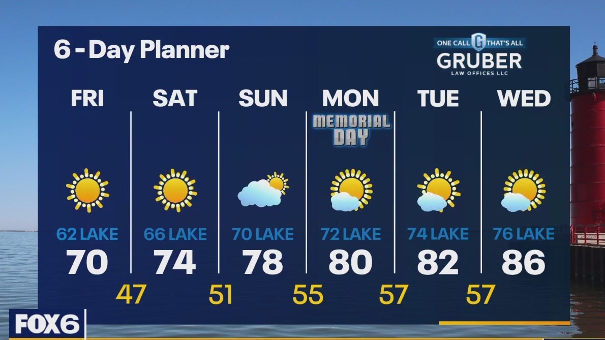
Weather webcast with Rob Haswell
High pressure settles into today delivering more sun but still slightly cooler temperatures. A blocking pattern known as a Rex Block will establish itself in the upper atmosphere resulting in a long sunny dry stretch with steadily warming temperatures. We warm into the mid to upper 70s by the weekend and into the 80s by Memorial Day. Current warming trend will take us into the upper 80s to near 90 by the middle of next week!
High pressure settles into today delivering more sun but still slightly cooler temperatures. A blocking pattern known as a Rex Block will establish itself in the upper atmosphere resulting in a long sunny dry stretch with steadily warming temperatures. We warm into the mid to upper 70s by the weekend and into the 80s by Memorial Day. Current warming trend will take us into the upper 80s to near 90 by the middle of next week!
Weather Webcast with Meteorologist Eric Manges
Chilly Thursday but also bone dry and warmer long term
Chilly Thursday but also bone dry and warmer long term
Weather Webcast with Meteorologist Eric Manges
Staying cooler tomorrow but temperatures rebound quickly into the weekend
Staying cooler tomorrow but temperatures rebound quickly into the weekend

Weather Webcast With Lisa Michaels
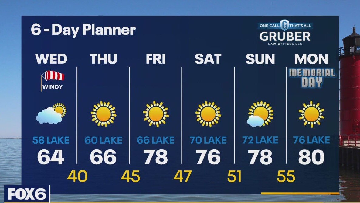
A "backdoor cold front" moved through this morning dropping our temperatures and creating a gusty NE wind today . Temperatures will be in the 50s and 60s today and feel cooler with a NE wind gusting into the 30mph range at times. We will get back to sun by later today and stay sunny and cooler tomorrow. We warm back up later this week and into the long weekend. Highs will be in the mid to upper70s and low 80s for the Memorial Day weekend.
A "backdoor cold front" moved through this morning dropping our temperatures and creating a gusty NE wind today . Temperatures will be in the 50s and 60s today and feel cooler with a NE wind gusting into the 30mph range at times. We will get back to sun by later today and stay sunny and cooler tomorrow. We warm back up later this week and into the long weekend. Highs will be in the mid to upper70s and low 80s for the Memorial Day weekend.
Weather webcast with Rob Haswell
A "backdoor cold front" completes its push through our area this morning dropping our temperatures and creating a gusty NE wind. Temperatures will be in the 50s and 60s today and feel cooler with a NE wind gusting into the 30mph range at times. We will get back to sun by later today and stay sunny and cooler tomorrow. We warm back up later this week and into the long weekend. Highs will be in the mid to upper70s and low 80s for the Memorial Day weekend.
A "backdoor cold front" completes its push through our area this morning dropping our temperatures and creating a gusty NE wind. Temperatures will be in the 50s and 60s today and feel cooler with a NE wind gusting into the 30mph range at times. We will get back to sun by later today and stay sunny and cooler tomorrow. We warm back up later this week and into the long weekend. Highs will be in the mid to upper70s and low 80s for the Memorial Day weekend.