

Weather Webcast with Meteorologist Eric Manges
Finally some rain today and another chance heading into the weekend
Finally some rain today and another chance heading into the weekend
Weather webcast with Lisa Michaels
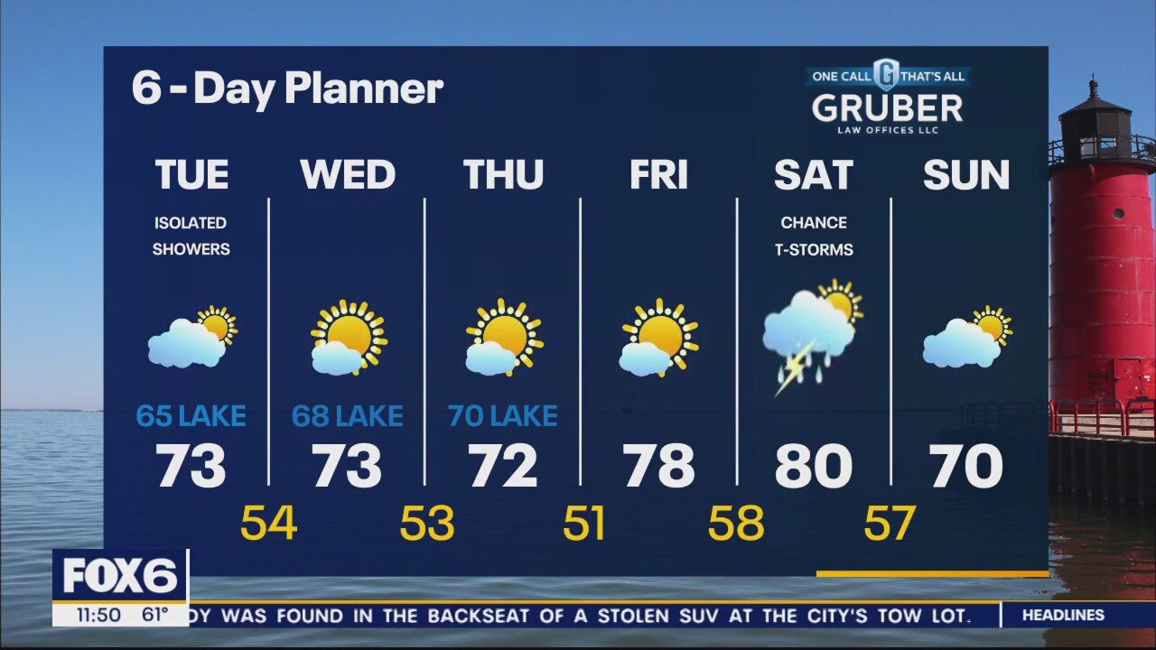
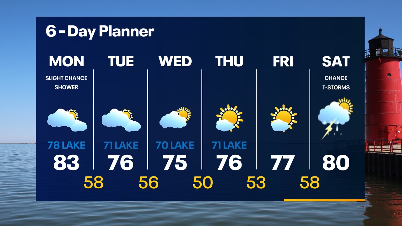
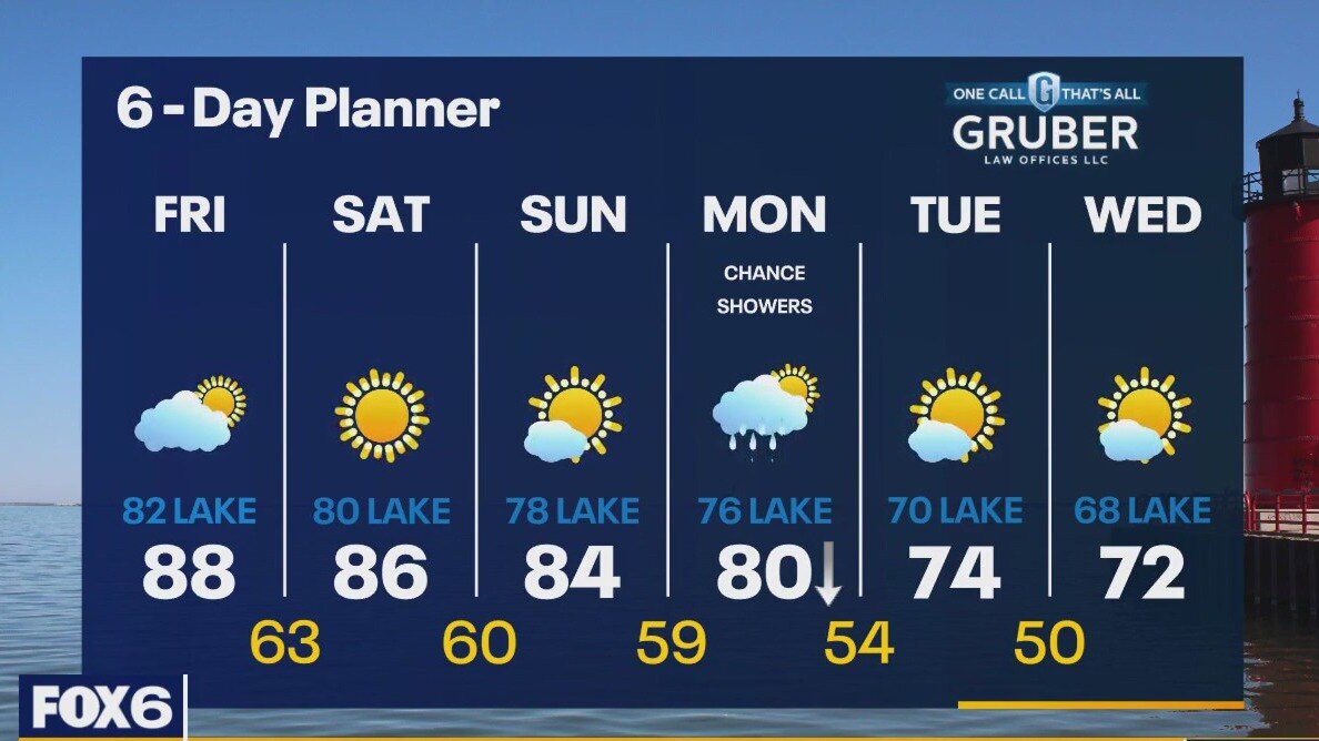
A slow moving cold front will bring increased cloud cover today and the chance of a few showers. Morning temps in the 60s. Lingering smoke from wildfires persists. Mostly cloudy skies with highs in the low 70s. Mid to upper 60s near the lake. Behind this front will be more seasonal temps in the mid 70s. Still remaining dry this week. A gradual warm up by Friday. There is a chance for thunderstorms on Saturday with a cold front.
A slow moving cold front will bring increased cloud cover today and the chance of a few showers. Morning temps in the 60s. Lingering smoke from wildfires persists. Mostly cloudy skies with highs in the low 70s. Mid to upper 60s near the lake. Behind this front will be more seasonal temps in the mid 70s. Still remaining dry this week. A gradual warm up by Friday. There is a chance for thunderstorms on Saturday with a cold front.
Weather Webcast with Tom Wachs
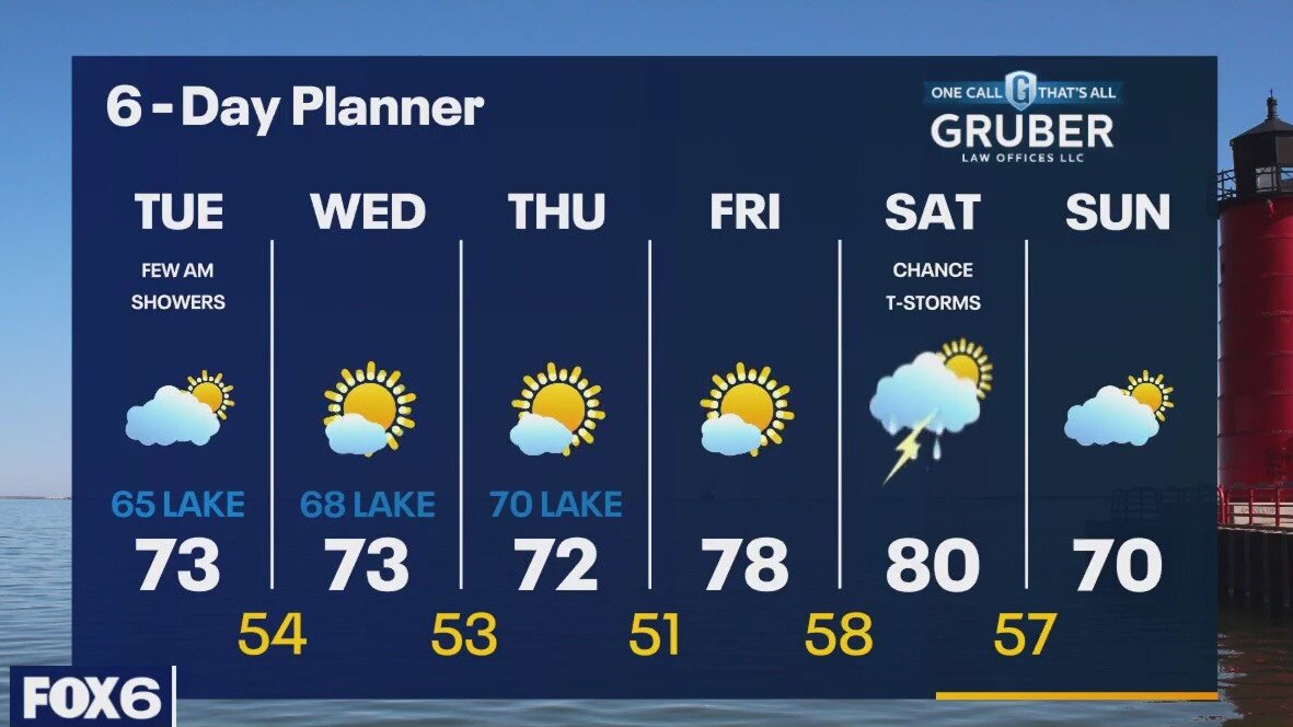
A few spotty rain showers possible overnight into Tuesday morning. Temperatures in the upper 50s by sunrise. After a few scattered morning showers, expect a cooler Tuesday with highs in the 70s inland, upper 60s near the lake.
A few spotty rain showers possible overnight into Tuesday morning. Temperatures in the upper 50s by sunrise. After a few scattered morning showers, expect a cooler Tuesday with highs in the 70s inland, upper 60s near the lake.
Weather Webcast with Tom Wachs
Smoky skies tonight with a chance for a few rain showers overnight into Tuesday morning. Temperatures dropping into the upper 50s. Much cooler on Tuesday with highs in the upper 60s to low 70s.
Smoky skies tonight with a chance for a few rain showers overnight into Tuesday morning. Temperatures dropping into the upper 50s. Much cooler on Tuesday with highs in the upper 60s to low 70s.
Weather webcast with Rob Haswell
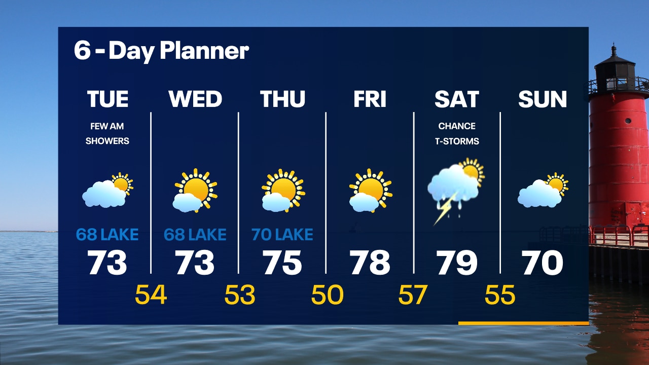
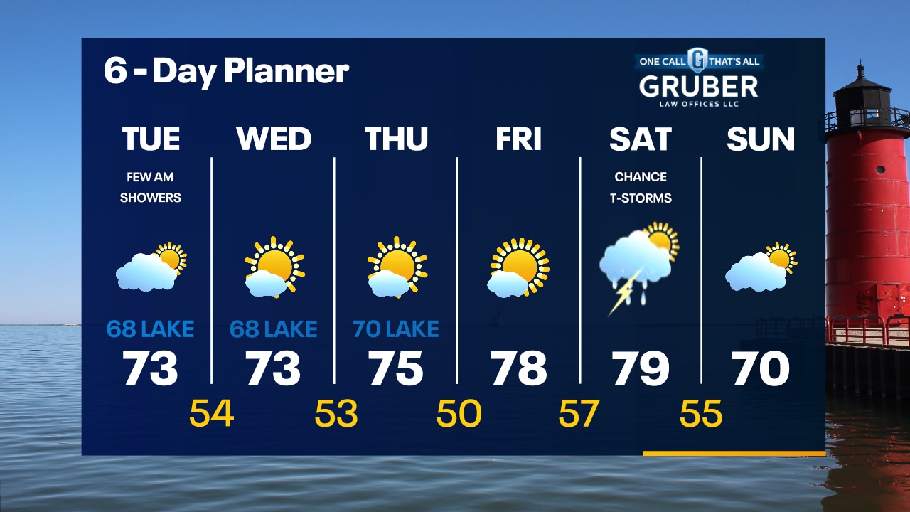
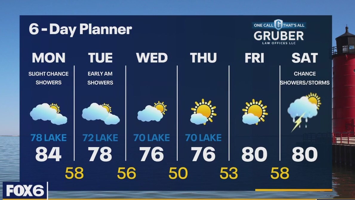
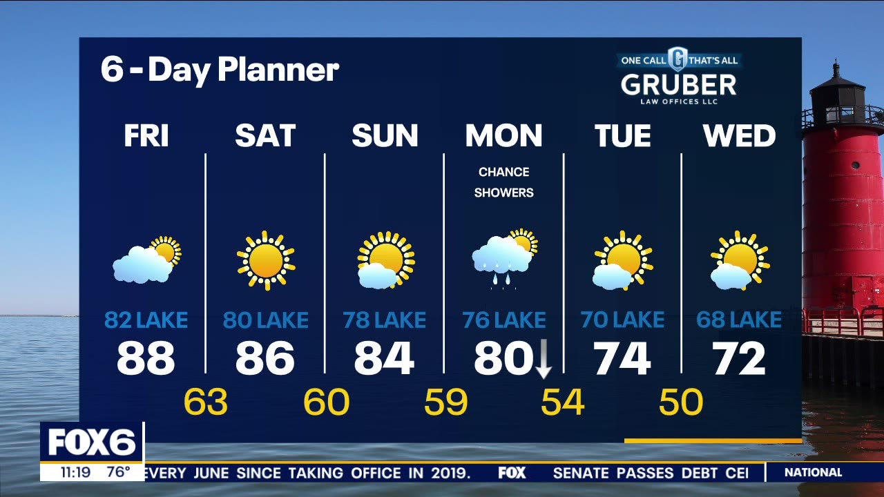
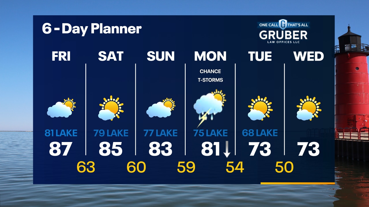
Wildfire smoke is still an issue four our areas with an Air Quality Alert in place. Highs today will get to the low 80s with 70s near the lake. There is a slight chance for a few showers. A passing cold front will help to clear some of the smoke in our air. After a few morning showers Tuesday we clear up and dry up. Highs will fall to the 70s. We stay sunny and seasonal Wednesday through Friday with a chance for showers this weekend.
Wildfire smoke is still an issue four our areas with an Air Quality Alert in place. Highs today will get to the low 80s with 70s near the lake. There is a slight chance for a few showers. A passing cold front will help to clear some of the smoke in our air. After a few morning showers Tuesday we clear up and dry up. Highs will fall to the 70s. We stay sunny and seasonal Wednesday through Friday with a chance for showers this weekend.

Weather Webcast with Tom Wachs
Smoky skies at times on Monday with highs in the mid-80s inland, upper 70s near the lake. A few rain showers are possible Monday morning and again later in the evening.
Smoky skies at times on Monday with highs in the mid-80s inland, upper 70s near the lake. A few rain showers are possible Monday morning and again later in the evening.
Weather Webcast with Tom Wachs
Smoky skies tonight with temperatures dropping through the 60s this evening and into the 50s overnight. There is a slight chance for a shower on Monday with highs in the 80s inland, 70s near the lake. Smoky skies continue through Tuesday morning.
Smoky skies tonight with temperatures dropping through the 60s this evening and into the 50s overnight. There is a slight chance for a shower on Monday with highs in the 80s inland, 70s near the lake. Smoky skies continue through Tuesday morning.
Weather webcast with Rob Haswell
A hazy morning with wildfire smoke in the air from fires in Ontario and Northern Michigan. Slightly cooler today with highs near 80 inland and low to mid 70 lakeside. We stay dry again today.
A hazy morning with wildfire smoke in the air from fires in Ontario and Northern Michigan. Slightly cooler today with highs near 80 inland and low to mid 70 lakeside. We stay dry again today.

Weather Webcast with Meteorologist Lisa Michaels
Mostly sunny and warm on Saturday. Highs in the upper 80s inland, around 80 near the lake. Still warm on Sunday in the low 80s but slightly cooler. Mid 70s near the lake.
Mostly sunny and warm on Saturday. Highs in the upper 80s inland, around 80 near the lake. Still warm on Sunday in the low 80s but slightly cooler. Mid 70s near the lake.
Weather Webcast with Tom Wachs
Mostly clear overnight with temperatures falling to around 60 by sunrise. Mostly sunny and warm on Saturday with highs in the upper 80s Waukesha and west, around 80 near the lake.
Mostly clear overnight with temperatures falling to around 60 by sunrise. Mostly sunny and warm on Saturday with highs in the upper 80s Waukesha and west, around 80 near the lake.

Weather Webcast with Tom Wachs
Mostly clear tonight with temperatures falling through the 70s this evening before settling around 60 by sunrise. Mostly sunny and warm on Saturday. Highs in the 80s.
Mostly clear tonight with temperatures falling through the 70s this evening before settling around 60 by sunrise. Mostly sunny and warm on Saturday. Highs in the 80s.
Weather Webcast With Lisa Michaels
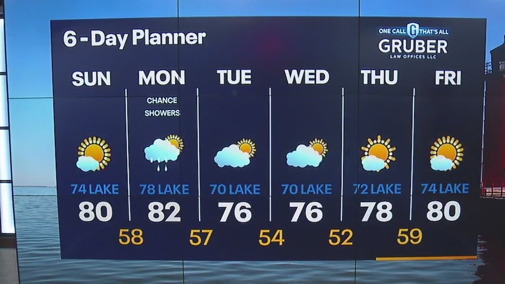
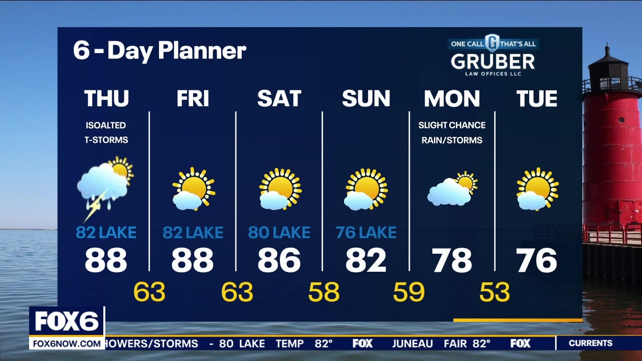
Another hot and humid day with highs in the upper 80s inland and low 80s lakeside. Dew points will be in the 60s. There is a very slight chance of a few showers this afternoon but most of this will be west of our viewing area. We have a warm and quiet weekend with highs in the low to mid 80s Saturday and low 80s Sunday. A fairly weak cold front slides through by Monday and temperatures return to the seasonal range for a few days.
Another hot and humid day with highs in the upper 80s inland and low 80s lakeside. Dew points will be in the 60s. There is a very slight chance of a few showers this afternoon but most of this will be west of our viewing area. We have a warm and quiet weekend with highs in the low to mid 80s Saturday and low 80s Sunday. A fairly weak cold front slides through by Monday and temperatures return to the seasonal range for a few days.
Weather webcast with Rob Haswell
Another hot and humid day with highs in the upper 80s inland and low 80s lakeside. Dewpoints will be in the 60s. There is a very slight chance of a few showers this afternoon but most of this will be west of our viewing area. We have a warm and quiet weekend with highs in the low to mid 80s Saturday and low 80s Sunday. A fairly weak cold front slides through by Monday and temperatures return to the seasonal range for a few days.
Another hot and humid day with highs in the upper 80s inland and low 80s lakeside. Dewpoints will be in the 60s. There is a very slight chance of a few showers this afternoon but most of this will be west of our viewing area. We have a warm and quiet weekend with highs in the low to mid 80s Saturday and low 80s Sunday. A fairly weak cold front slides through by Monday and temperatures return to the seasonal range for a few days.

Weather Webcast with Tom Wachs
Mostly clear overnight with temperatures in the 60s. Partly to mostly sunny and warm on Friday with highs in the 80s.
Mostly clear overnight with temperatures in the 60s. Partly to mostly sunny and warm on Friday with highs in the 80s.
Weather Webcast with Tom Wachs
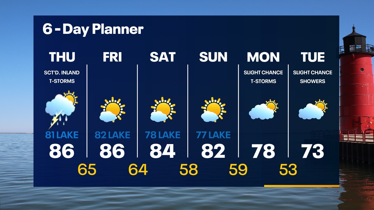
Inland t-storms coming to an end tonight, otherwise mostly clear. Temperatures dropping into the 60s overnight. Sunny and warm again on Friday with highs in the 80s.
Inland t-storms coming to an end tonight, otherwise mostly clear. Temperatures dropping into the 60s overnight. Sunny and warm again on Friday with highs in the 80s.
Weather Webcast With Lisa Michaels
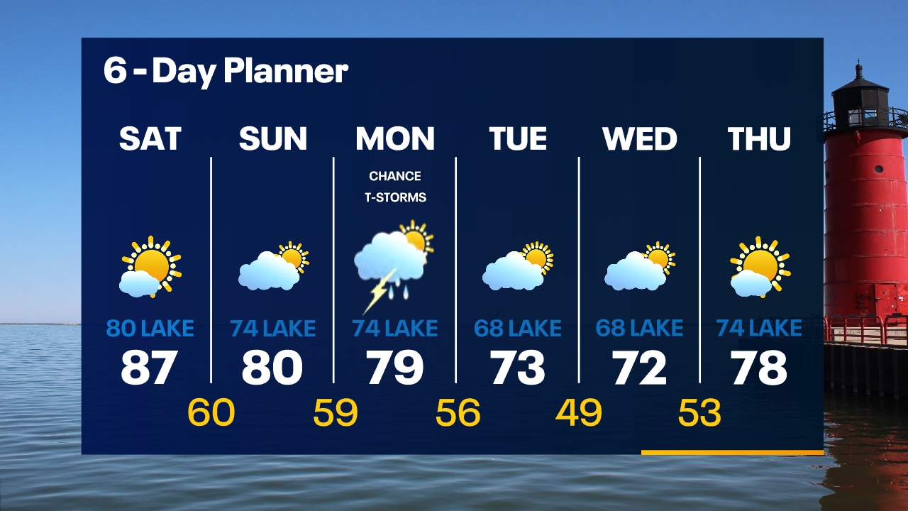
Another hot and increasingly humid day with a slight chance for isolated showers and thunderstorms this afternoon. Highs will be in the upper 80s inland and low 80s lakeside. We stay warm and humid on Friday but should stay dry. 80s continue on Saturday but a weak cold front will bring a bit of relief for Sunday as highs fall to the low 80s and 70s lakeside.
Another hot and increasingly humid day with a slight chance for isolated showers and thunderstorms this afternoon. Highs will be in the upper 80s inland and low 80s lakeside. We stay warm and humid on Friday but should stay dry. 80s continue on Saturday but a weak cold front will bring a bit of relief for Sunday as highs fall to the low 80s and 70s lakeside.

Weather webcast with Rob Haswell
Another hot and increasingly humid day with a slight chance for isolated showers and thunderstorms this afternoon. Highs will be in the upper 80s inland and low 80s lakeside. We stay warm and humid on Friday but should stay dry. We'll be well into the 80s on Saturday but a weak cold front will bring a bit of relief for Sunday as highs fall to the low 80s and 70s lakeside.
Another hot and increasingly humid day with a slight chance for isolated showers and thunderstorms this afternoon. Highs will be in the upper 80s inland and low 80s lakeside. We stay warm and humid on Friday but should stay dry. We'll be well into the 80s on Saturday but a weak cold front will bring a bit of relief for Sunday as highs fall to the low 80s and 70s lakeside.
Weather Webcast with Tom Wachs
Scattered inland t-storms will end by sunset. Temperatures dropping into the 60s tonight. Partly sunny, warm and humid again on Thursday. Scattered afternoon t-storms inland.
Scattered inland t-storms will end by sunset. Temperatures dropping into the 60s tonight. Partly sunny, warm and humid again on Thursday. Scattered afternoon t-storms inland.

FOX6 Weather webcast with Rob Haswell
More heat and humidity today with highs in the upper 80s and dewpoints in the upper 50s to near 60. Increased instability will lead to isolated showers and thunderstorms this afternoon and early evening.
More heat and humidity today with highs in the upper 80s and dewpoints in the upper 50s to near 60. Increased instability will lead to isolated showers and thunderstorms this afternoon and early evening.

Weather Webcast with Tom Wachs
Mostly clear overnight with temperatures in the 60s. Partly sunny, warm and humid on Wednesday. Highs in the 80s. Isolated afternoon/early evening t-storm possible.
Mostly clear overnight with temperatures in the 60s. Partly sunny, warm and humid on Wednesday. Highs in the 80s. Isolated afternoon/early evening t-storm possible.