

Weather webcast with Rob Haswell
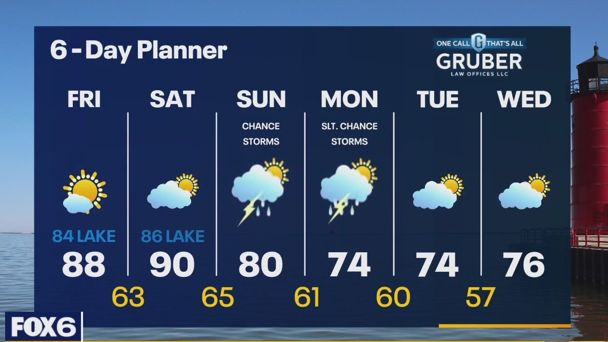
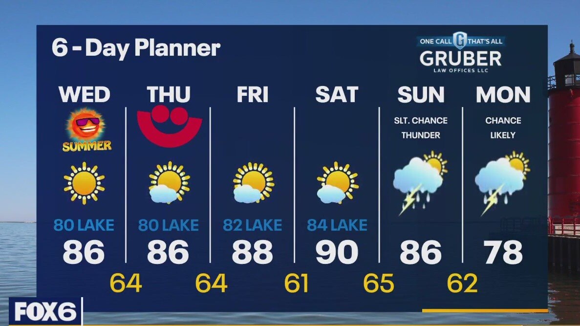
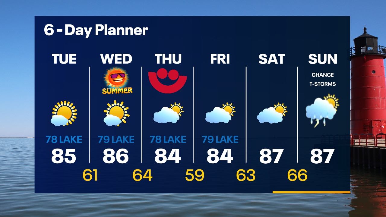
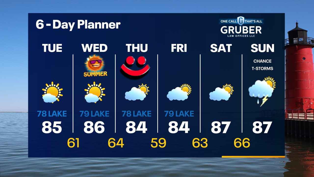
Air Quality Alert for All of SE WI until 11p.m. High pressure continues to be the big player for our forecast, keeping us sunny and dry with very warm temperatures. Highs will hit the upper 80s and near 90 today and tomorrow and then fall as a low finally arrives on Sunday. We have a chance for rain and thunderstorms Sunday and into Monday. Cooler air arrives for early next week.
Air Quality Alert for All of SE WI until 11p.m. High pressure continues to be the big player for our forecast, keeping us sunny and dry with very warm temperatures. Highs will hit the upper 80s and near 90 today and tomorrow and then fall as a low finally arrives on Sunday. We have a chance for rain and thunderstorms Sunday and into Monday. Cooler air arrives for early next week.

Weather Webcast with Tom Wachs
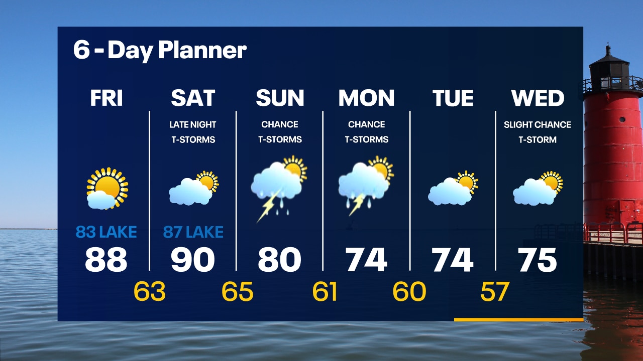
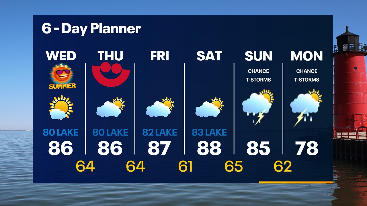
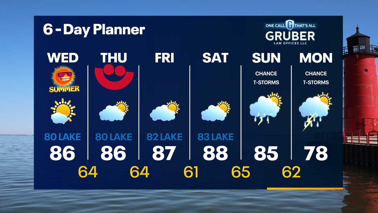
Smoky skies overnight and into Friday otherwise warm and sunny. Highs in the 80s on Friday. Warm again on Saturday. T-Storm chances return late Saturday night and Sunday.
Smoky skies overnight and into Friday otherwise warm and sunny. Highs in the 80s on Friday. Warm again on Saturday. T-Storm chances return late Saturday night and Sunday.
Weather Webcast with Tom Wachs
Clear skies tonight with temperatures falling through the 70s and into the 60s. Mostly sunny and warm again on Friday with highs in the 80s.
Clear skies tonight with temperatures falling through the 70s and into the 60s. Mostly sunny and warm again on Friday with highs in the 80s.

Weather Webcast with Meteorologist Eric Manges
Summer temps and sunshine into the weekend with rain potential Sunday
Summer temps and sunshine into the weekend with rain potential Sunday

Weather webcast with Eric Manges
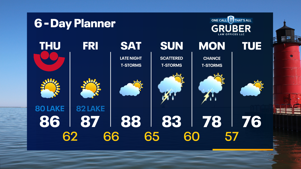
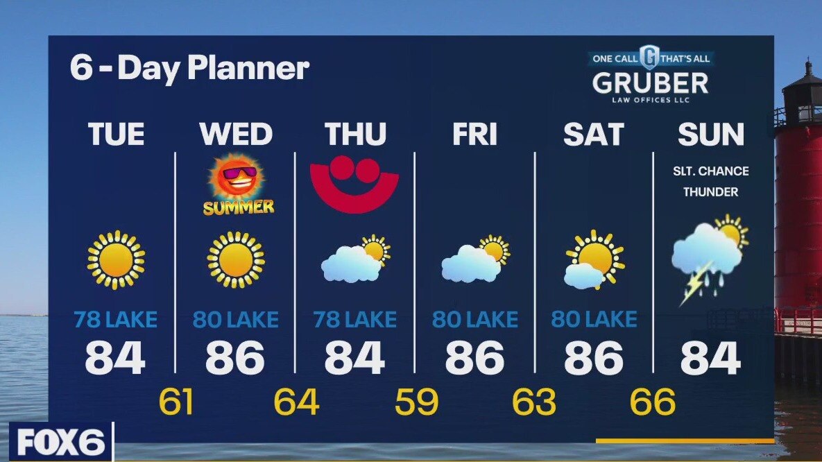
Air Quality Alert for All of SE WI until 11p.m. Friday. Plenty of sunshine to end the week and a great start to Summerfest. Highs in the mid-80s. Saturday stays nice too but finally rain potential returns Sunday and Monday. Scattered showers and storms move through to start the week but getting cooler by Tuesday
Air Quality Alert for All of SE WI until 11p.m. Friday. Plenty of sunshine to end the week and a great start to Summerfest. Highs in the mid-80s. Saturday stays nice too but finally rain potential returns Sunday and Monday. Scattered showers and storms move through to start the week but getting cooler by Tuesday

Weather Webcast with Tom Wachs
Clear skies overnight with temperatures in the 60s. Lots of sun for the start of Summerfest on Thursday. Highs in the 80s. Upper 70s to low 80s on the Summerfest grounds.
Clear skies overnight with temperatures in the 60s. Lots of sun for the start of Summerfest on Thursday. Highs in the 80s. Upper 70s to low 80s on the Summerfest grounds.
Weather Webcast with Tom Wachs
Clear skies tonight with temperatures falling into the 60s. Beautiful for the first day of Summerfest on Thursday with highs in the 80s. Lots of sun on the way once again.
Clear skies tonight with temperatures falling into the 60s. Beautiful for the first day of Summerfest on Thursday with highs in the 80s. Lots of sun on the way once again.
Weather Webcast with Meteorologist Eric Manges
Warm and sunny end of the week then rain potential Sunday and Monday
Warm and sunny end of the week then rain potential Sunday and Monday
Weather webcast with Rob Haswell
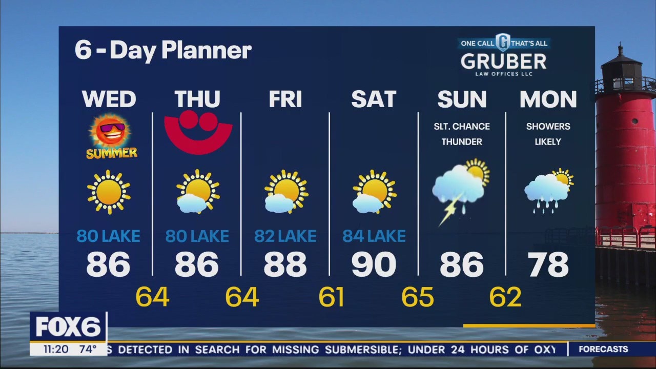
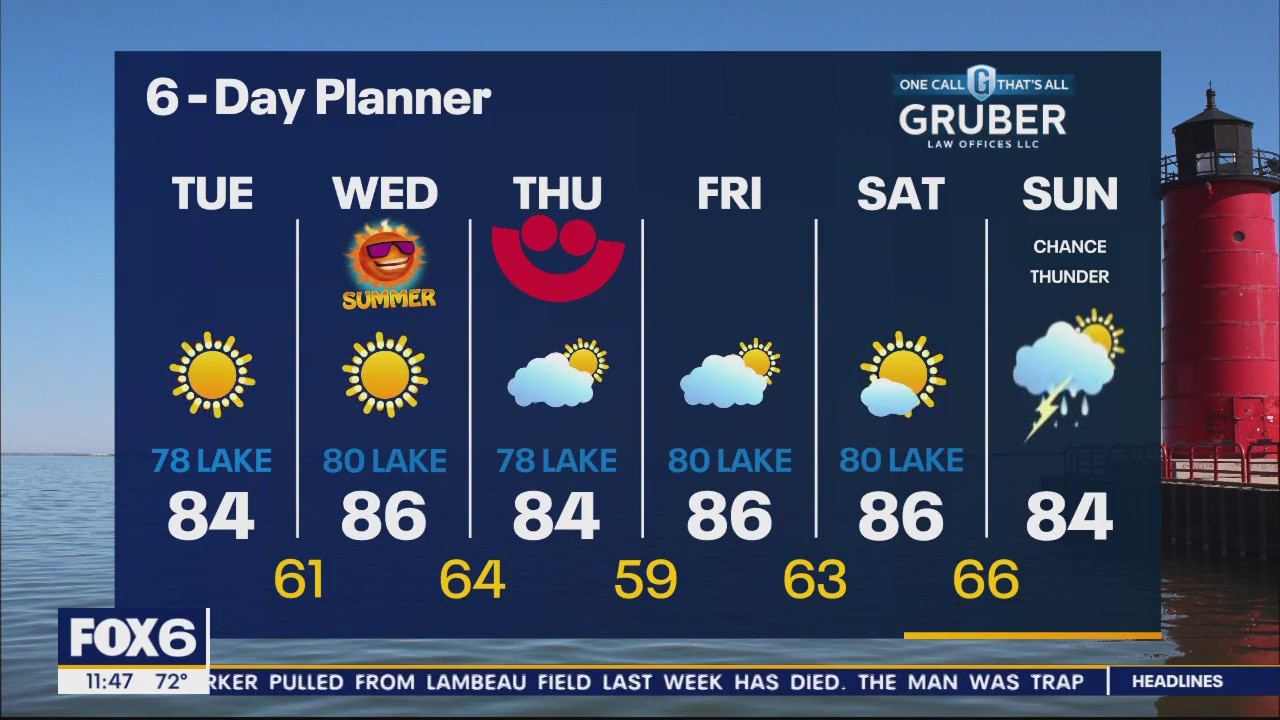
High pressure centered to our east holds tight for the next few days keeping us sunny, warm and dry. Highs will be well into the 80s and near 90 from today through Saturday with ample sunshine. A breeze off the lake will keep things in the low 80s lakeside. A low finally breaks through by Sunday with rain likely and a chance for thunderstorms. Rain showers linger into Monday before drying up on Tuesday. This much needed rain will do little to turn back the on-going drought.
High pressure centered to our east holds tight for the next few days keeping us sunny, warm and dry. Highs will be well into the 80s and near 90 from today through Saturday with ample sunshine. A breeze off the lake will keep things in the low 80s lakeside. A low finally breaks through by Sunday with rain likely and a chance for thunderstorms. Rain showers linger into Monday before drying up on Tuesday. This much needed rain will do little to turn back the on-going drought.
Weather Webcast with Tom Wachs
Clear skies overnight with temperatures in the 60s. Sunny and warm again on Wednesday. Highs in the 80s. Summer officially begins just before 10am.
Clear skies overnight with temperatures in the 60s. Sunny and warm again on Wednesday. Highs in the 80s. Summer officially begins just before 10am.
Weather Webcast with Tom Wachs
Clear skies tonight with the wind settling down. Temperatures will drop into the 60s. Mostly sunny and warm again on Wednesday. Highs in the 80s.
Clear skies tonight with the wind settling down. Temperatures will drop into the 60s. Mostly sunny and warm again on Wednesday. Highs in the 80s.
Weather Webcast with Meteorologist Eric Manges
Summer-like end to Spring just keeps going through the start of Summer with warm temps and plenty of sunshine
Summer-like end to Spring just keeps going through the start of Summer with warm temps and plenty of sunshine
Weather webcast with Rob Haswell
High pressure centered to our east dominates our forecast for the next several days. This high will keep us dry and steadily warming. Highs will get to the low to mid 80s inland from today through the weekend. Areas lakeside will be in the upper 70s and low 80s. Sunday brings our next best chance for rain and thunderstorms.
High pressure centered to our east dominates our forecast for the next several days. This high will keep us dry and steadily warming. Highs will get to the low to mid 80s inland from today through the weekend. Areas lakeside will be in the upper 70s and low 80s. Sunday brings our next best chance for rain and thunderstorms.
Weather Webcast with Tom Wachs
Clear skies overnight with temperatures in the upper 50s to low 60s by sunrise. Mostly sunny and warm again on Tuesday, but becoming breezy. Highs in the 80s inland, upper 70s near the lake.
Clear skies overnight with temperatures in the upper 50s to low 60s by sunrise. Mostly sunny and warm again on Tuesday, but becoming breezy. Highs in the 80s inland, upper 70s near the lake.
Weather Webcast with Tom Wachs
Clear skies tonight with temperatures dropping into the 60s. Another warm and sunny day on Tuesday with highs in the 80s inland, 70s near the lake.
Clear skies tonight with temperatures dropping into the 60s. Another warm and sunny day on Tuesday with highs in the 80s inland, 70s near the lake.

Weather Webcast with Meteorologist Lisa Michaels
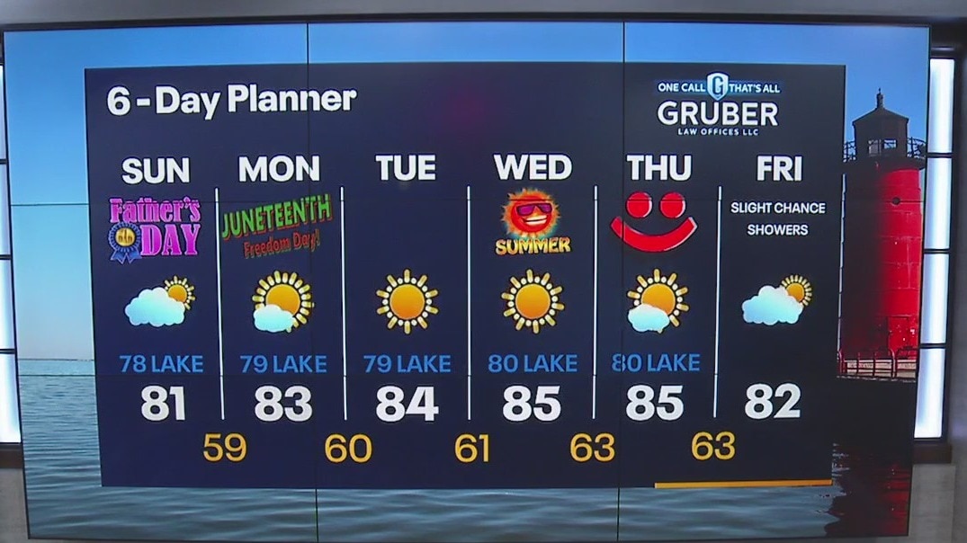
Light fog Monday morning with mild temps in the low 60s. Mostly sunny on Juneteenth Day with highs in the low to middle 80s inland, around 80 near the lake.
Light fog Monday morning with mild temps in the low 60s. Mostly sunny on Juneteenth Day with highs in the low to middle 80s inland, around 80 near the lake.

Weather Webcast with Tom Wachs
Partly to mostly cloudy overnight with temperatures falling through the 60s. Morning clouds and afternoon sun on Monday with highs in the 80s.
Partly to mostly cloudy overnight with temperatures falling through the 60s. Morning clouds and afternoon sun on Monday with highs in the 80s.

Weather Webcast with Tom Wachs
Partly to mostly cloudy tonight with temperatures in the 60s. A few morning clouds on Monday with afternoon sun. Highs in the 80s.
Partly to mostly cloudy tonight with temperatures in the 60s. A few morning clouds on Monday with afternoon sun. Highs in the 80s.
Weather Webcast with Meteorologist Lisa Michaels
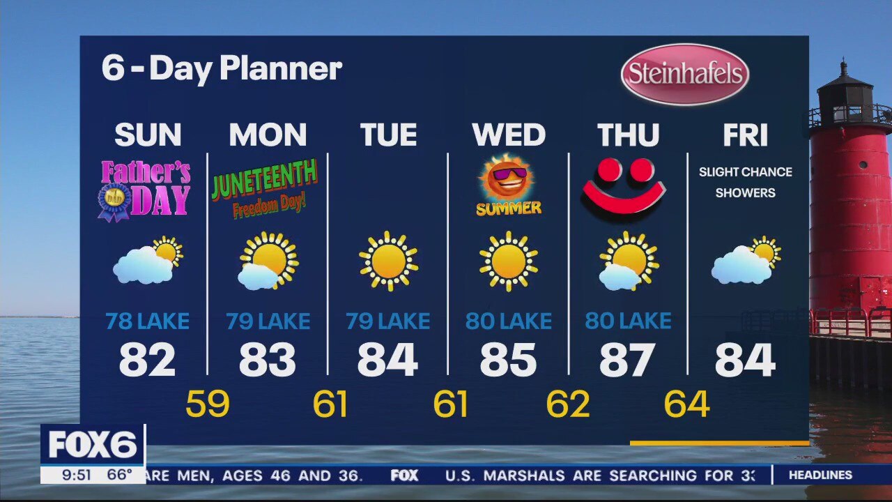
Increasing cloud cover through today. Highs will range in the mid 70s near the lake to the low 80s inland. Small chance for an isolated shower inland. Most location will stay dry today. No chances of rain through the week other than Friday with a slight chance of showers.
Increasing cloud cover through today. Highs will range in the mid 70s near the lake to the low 80s inland. Small chance for an isolated shower inland. Most location will stay dry today. No chances of rain through the week other than Friday with a slight chance of showers.
Weather Webcast with Meteorologist Eric Manges
Warm and dry this week but finally some rain chances heading into next weekend
Warm and dry this week but finally some rain chances heading into next weekend