

Weather webcast with Rob Haswell
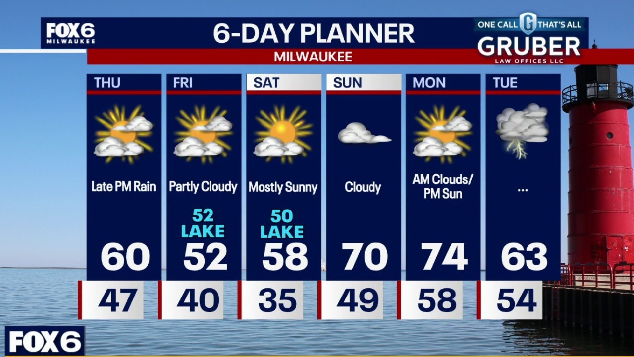
A pair of rain chances bookend the short-term forecast, with showers exiting early Thursday before another widespread round develops Thursday night, supported by strong mid-level forcing and a returning low-level jet.
A pair of rain chances bookend the short-term forecast, with showers exiting early Thursday before another widespread round develops Thursday night, supported by strong mid-level forcing and a returning low-level jet.
Weather Webcast with Chief Meteorologist Tom Wachs
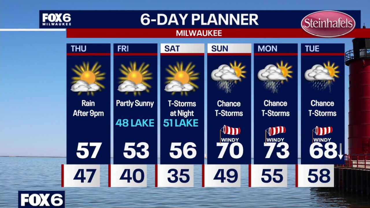
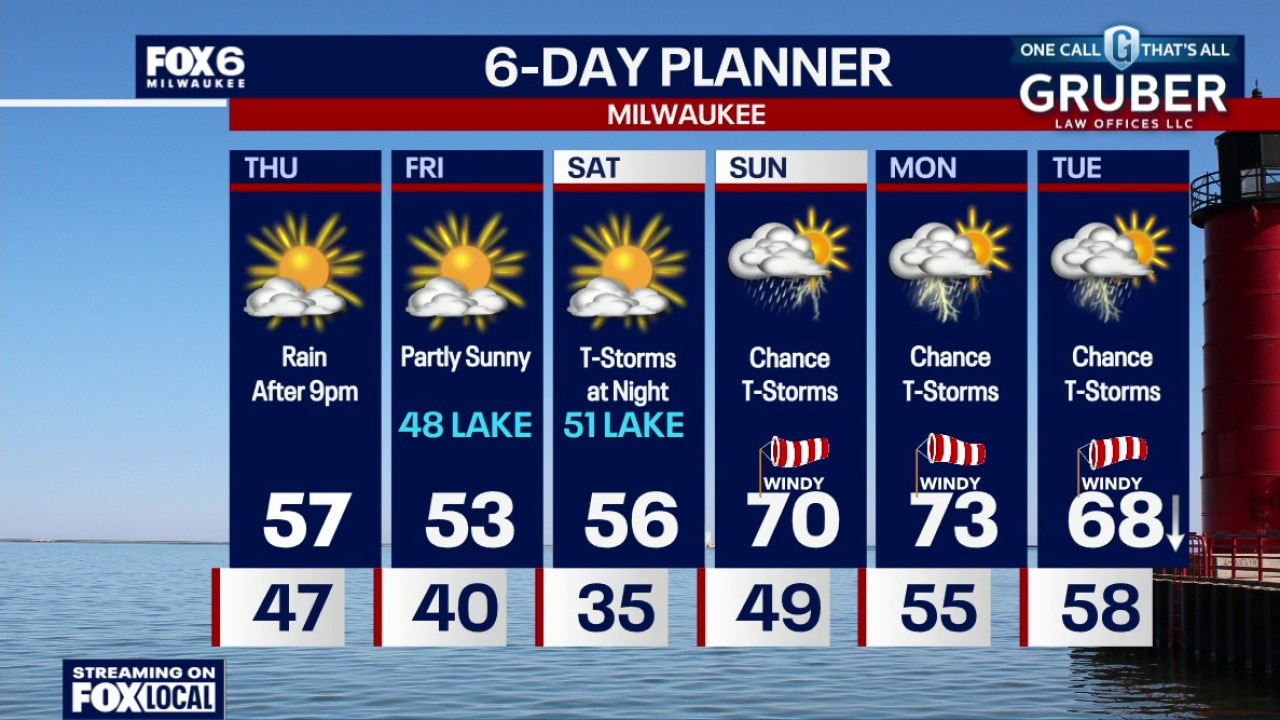
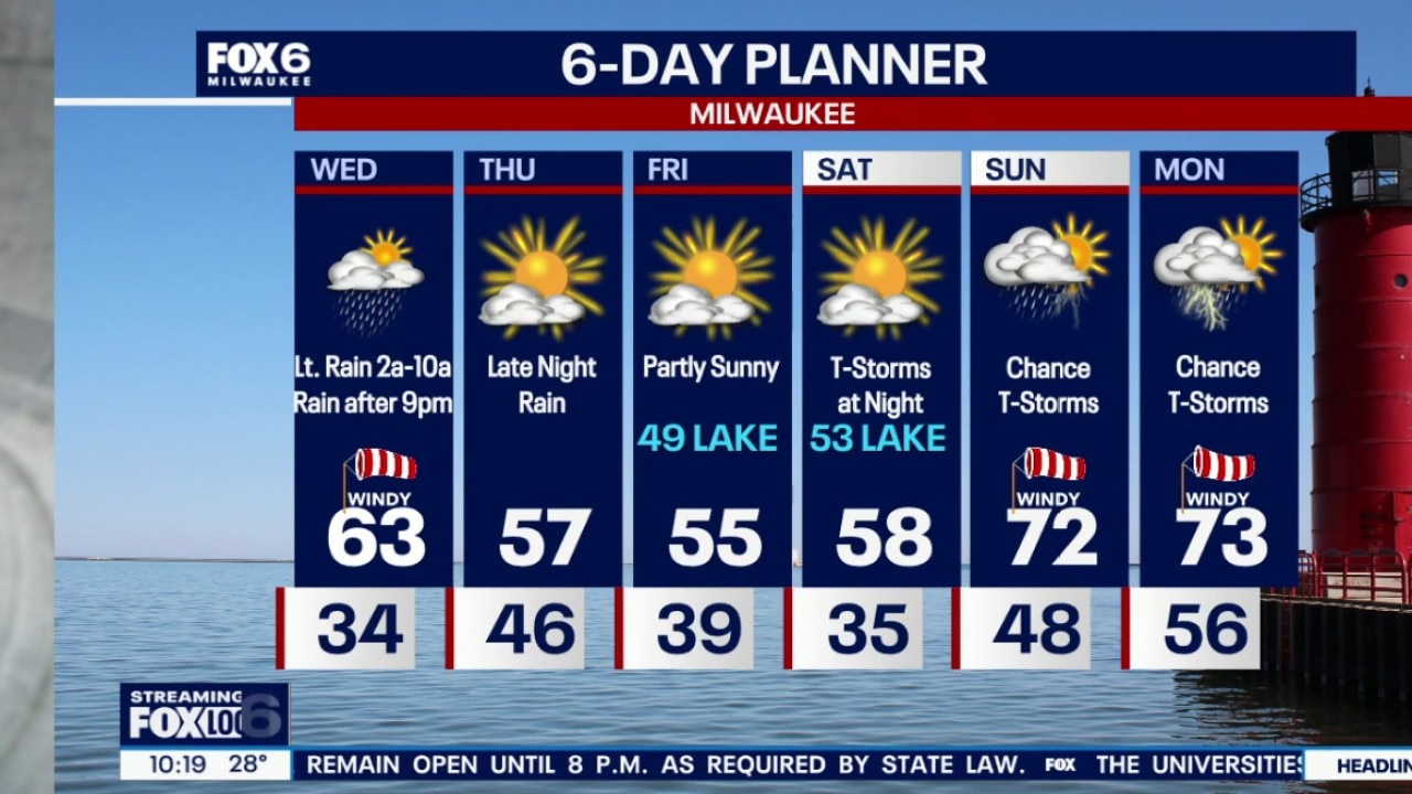
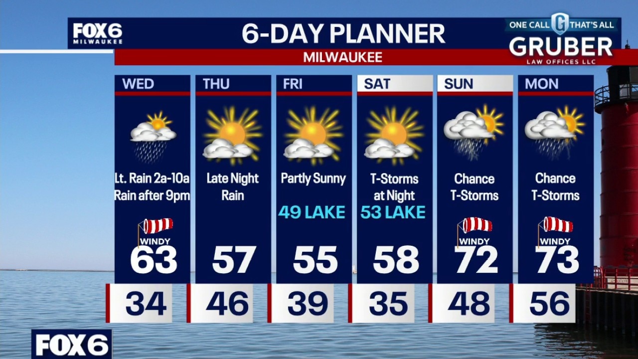
Light rain showers overnight. The wind will gradually settle down. Temperatures will drop into the 40s overnight with rain showers ending by 5am. Less than 0.10" in most areas. Partly sunny and cooler on Thursday with highs in the upper 50s. Another batch of rain moves in after 9pm and ends overnight. This could produce some heavier rain, 0.50"-1.00" possible in spots.
Light rain showers overnight. The wind will gradually settle down. Temperatures will drop into the 40s overnight with rain showers ending by 5am. Less than 0.10" in most areas. Partly sunny and cooler on Thursday with highs in the upper 50s. Another batch of rain moves in after 9pm and ends overnight. This could produce some heavier rain, 0.50"-1.00" possible in spots.
Weather Webcast with Chief Meteorologist Tom Wachs
Light rain showers tonight, especially overnight. Windy this evening with temperatures in the 50s. We will drop into the 40s overnight with rain showers ending by 5am. Less than 0.10" in most areas. Partly sunny and cooler on Thursday with highs in the upper 50s. Another batch of rain moves in after 9pm and ends overnight. This could produce some heavier rain, 0.50"-1.00" possible in spots.
Light rain showers tonight, especially overnight. Windy this evening with temperatures in the 50s. We will drop into the 40s overnight with rain showers ending by 5am. Less than 0.10" in most areas. Partly sunny and cooler on Thursday with highs in the upper 50s. Another batch of rain moves in after 9pm and ends overnight. This could produce some heavier rain, 0.50"-1.00" possible in spots.
Weather Webcast with Stephanie Barichello
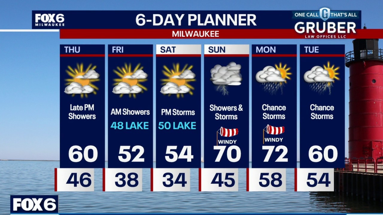
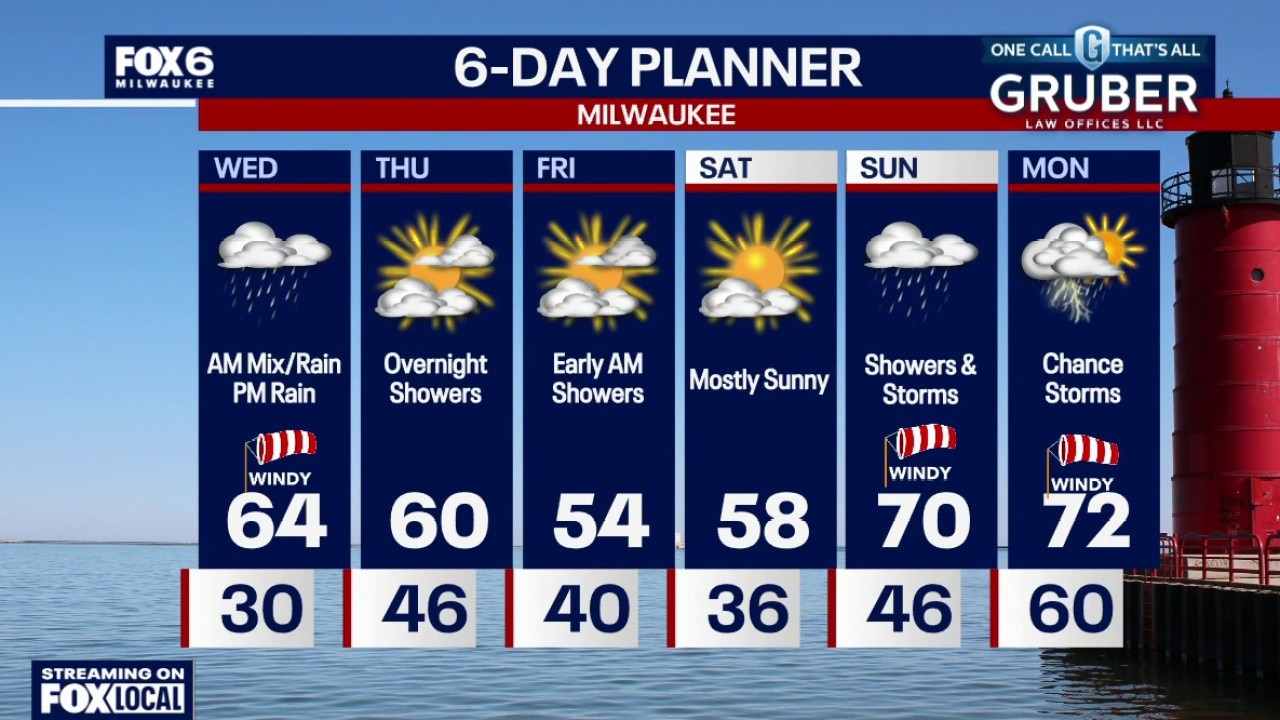
Rain showers return tonight, cooling temperatures a bit on Thursday, then another round of somewhat heavier rain Thursday night into Friday morning. Cooler Friday and Saturday then warming into the 70s. Thunderstorms chances continue into early next week.
Rain showers return tonight, cooling temperatures a bit on Thursday, then another round of somewhat heavier rain Thursday night into Friday morning. Cooler Friday and Saturday then warming into the 70s. Thunderstorms chances continue into early next week.
Weather webcast with Stephanie Barichello
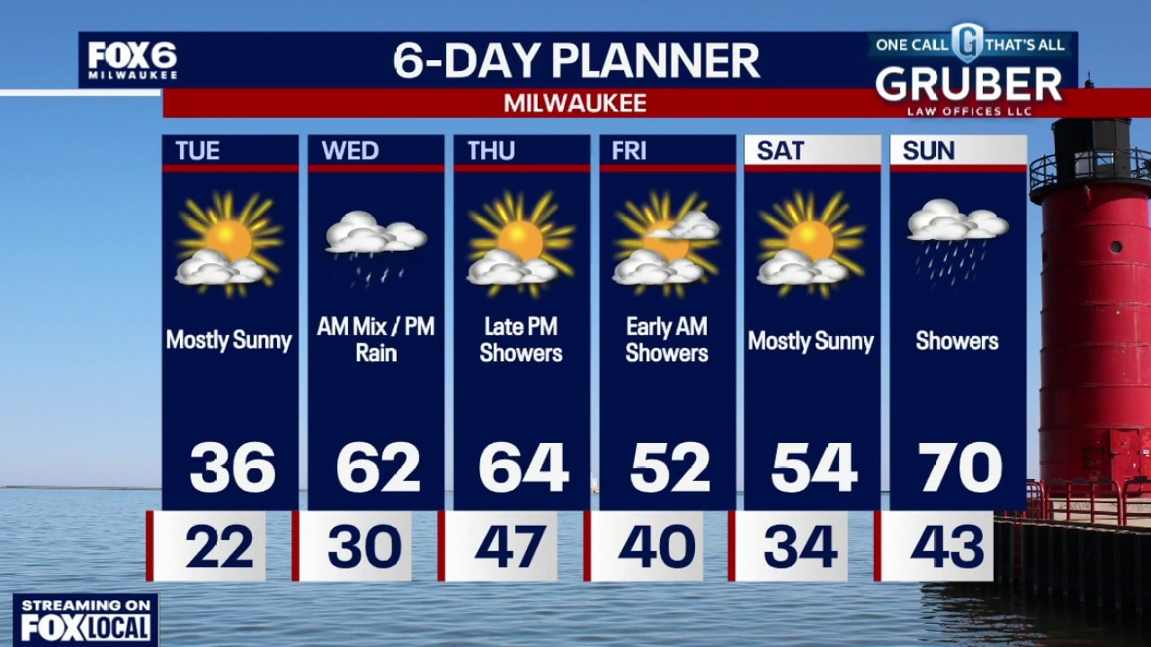
A brief wintry mix overnight gives way to a sharp warm-up Wednesday as strong southerly flow pushes temperatures well into the 60s with gusty winds.
A brief wintry mix overnight gives way to a sharp warm-up Wednesday as strong southerly flow pushes temperatures well into the 60s with gusty winds.
Weather webcast with Rob Haswell
A brief wintry mix overnight gives way to a sharp warm-up Wednesday as strong southerly flow pushes temperatures well into the 60s with gusty winds.
A brief wintry mix overnight gives way to a sharp warm-up Wednesday as strong southerly flow pushes temperatures well into the 60s with gusty winds.
Weather Webcast with Chief Meteorologist Tom Wachs
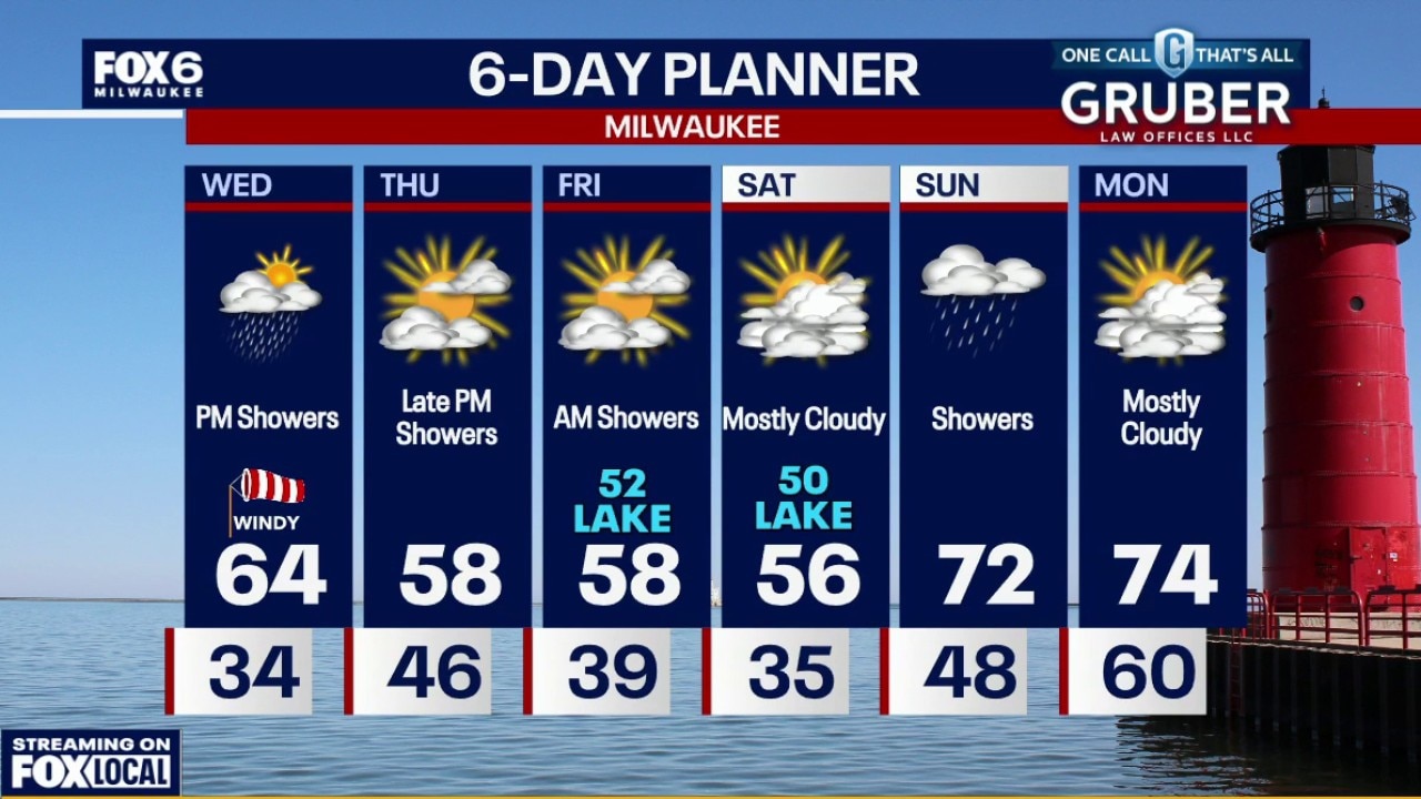
Freezing rain/rain showers possible after 2am. Temperatures in the low 30s overnight. Temperatures will warm above freezing by sunrise, so no icing concerns for the AM commute. Rain showers possible through 10am, otherwise mostly cloudy and windy. Highs in the low-to-mid 60s.
Freezing rain/rain showers possible after 2am. Temperatures in the low 30s overnight. Temperatures will warm above freezing by sunrise, so no icing concerns for the AM commute. Rain showers possible through 10am, otherwise mostly cloudy and windy. Highs in the low-to-mid 60s.
Weather Webcast with Chief Meteorologist Tom Wachs
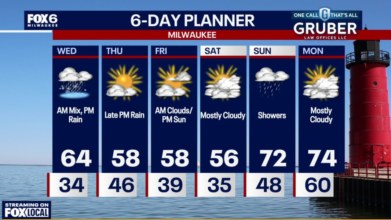
Increasing clouds tonight with temperatures around 30. Freezing rain/rain showers possible after 2am. Temperatures will warm above freezing by sunrise, so no icing concerns for the AM commute. Rain showers possible through 10am, otherwise mostly cloudy and windy. Highs in the low-to-mid 60s.
Increasing clouds tonight with temperatures around 30. Freezing rain/rain showers possible after 2am. Temperatures will warm above freezing by sunrise, so no icing concerns for the AM commute. Rain showers possible through 10am, otherwise mostly cloudy and windy. Highs in the low-to-mid 60s.
Weather Webcast with Stephanie Barichello
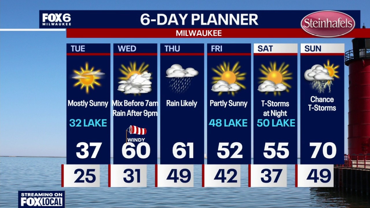
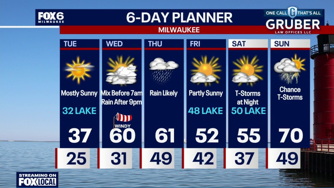
Rain and some brief wintry mix overnight, then warm and windy Wednesday afternoon. More rain Wednesday night into Thursday morning and Thursday night into Friday morning. A bit stormy but warmer to end the weekend.
Rain and some brief wintry mix overnight, then warm and windy Wednesday afternoon. More rain Wednesday night into Thursday morning and Thursday night into Friday morning. A bit stormy but warmer to end the weekend.
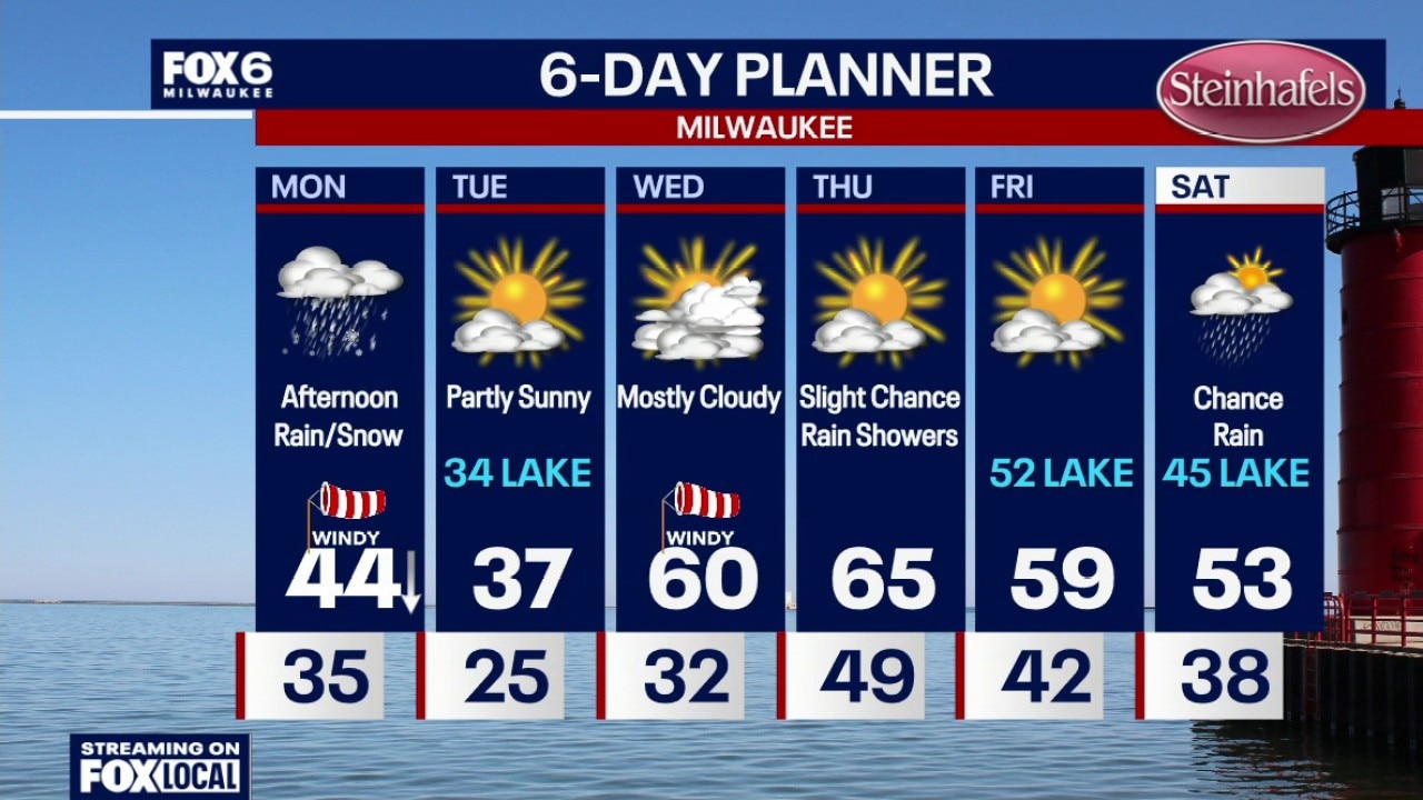
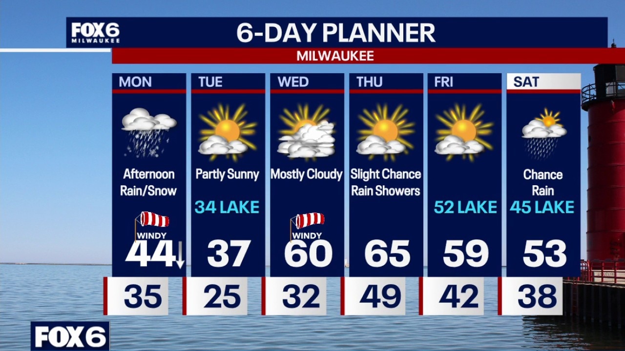
Weather webcast with Chief Meteorologist Rob Haswell
A transition period is underway across southern Wisconsin, beginning with a cold Tuesday morning and light wintry mix Tuesday night.
A transition period is underway across southern Wisconsin, beginning with a cold Tuesday morning and light wintry mix Tuesday night.
Weather Webcast with Chief Meteorologist Tom Wachs
Spotty snow showers will end overnight. It will be brisk with temperatures settling in the 20s by sunrise. Mostly sunny and chilly on Tuesday. Highs in the 30s, coolest near the lake. A blustery ESE wind will keep wind chills in the 20s all day.
Spotty snow showers will end overnight. It will be brisk with temperatures settling in the 20s by sunrise. Mostly sunny and chilly on Tuesday. Highs in the 30s, coolest near the lake. A blustery ESE wind will keep wind chills in the 20s all day.
Weather Webcast with Chief Meteorologist Tom Wachs
Spotty snow showers will end overnight. It will be brisk with temperatures dropping through the 30s and settling in the 20s overnight. Mostly sunny and chilly on Tuesday. Highs in the 30s, coolest near the lake. A blustery ESE wind will keep wind chills in the 20s all day.
Spotty snow showers will end overnight. It will be brisk with temperatures dropping through the 30s and settling in the 20s overnight. Mostly sunny and chilly on Tuesday. Highs in the 30s, coolest near the lake. A blustery ESE wind will keep wind chills in the 20s all day.
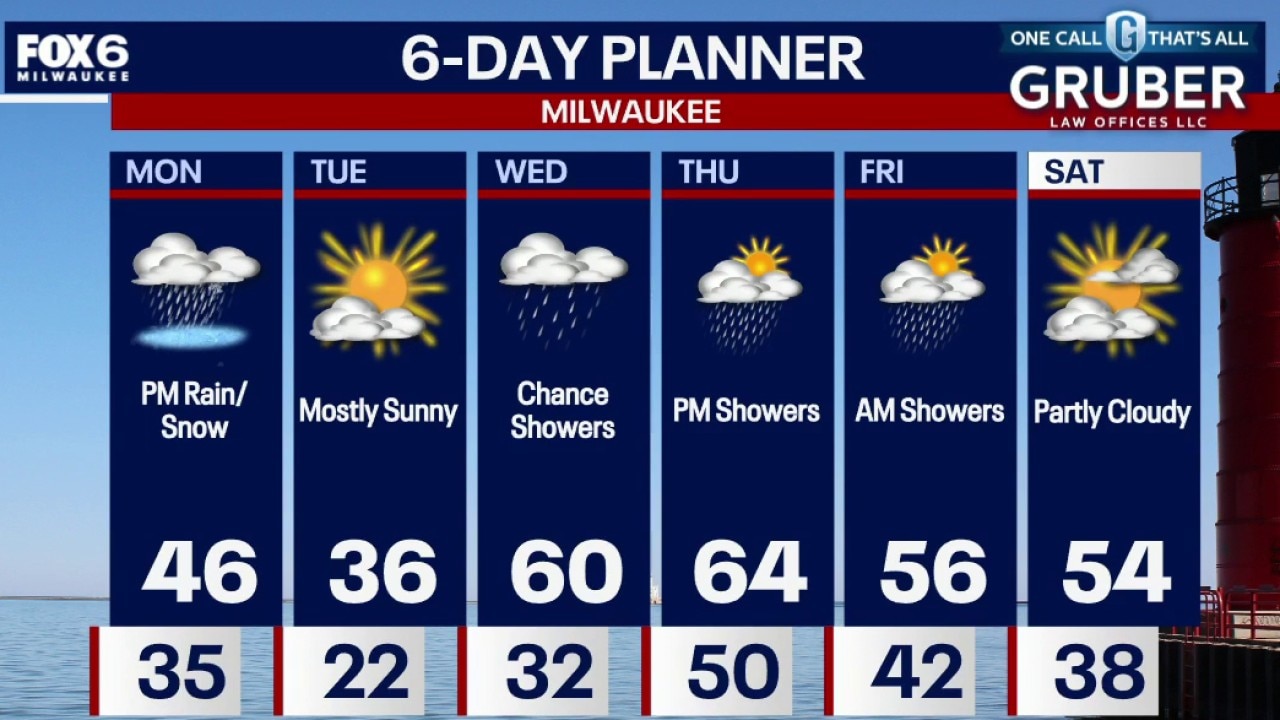
Weather webcast with Chief Meteorologist Rob Haswell
A brief but impactful round of convective rain/snow showers will develop Monday afternoon into the evening, bringing minor travel impacts. Any wet surfaces may refreeze Monday night as temperatures fall, creating localized slick spots.
A brief but impactful round of convective rain/snow showers will develop Monday afternoon into the evening, bringing minor travel impacts. Any wet surfaces may refreeze Monday night as temperatures fall, creating localized slick spots.
Weather Webcast with Chief Meteorologist Tom Wachs
A cold front will move in from the northwest tonight, bringing with it a few showers and t-storms until 1am. Generally less than 0.10" of rain. Partly sunny on Monday morning, but becoming windy. A midday high in the mid-40s. Another cold front moves in on Monday afternoon with rain/snow showers and falling temperatures.
A cold front will move in from the northwest tonight, bringing with it a few showers and t-storms until 1am. Generally less than 0.10" of rain. Partly sunny on Monday morning, but becoming windy. A midday high in the mid-40s. Another cold front moves in on Monday afternoon with rain/snow showers and falling temperatures.
Weather Webcast with Chief Meteorologist Tom Wachs
A cold front will move in from the northwest tonight bringing with it a few showers and t-storms until 1am. Generally less than 0.10" of rain.
A cold front will move in from the northwest tonight bringing with it a few showers and t-storms until 1am. Generally less than 0.10" of rain.
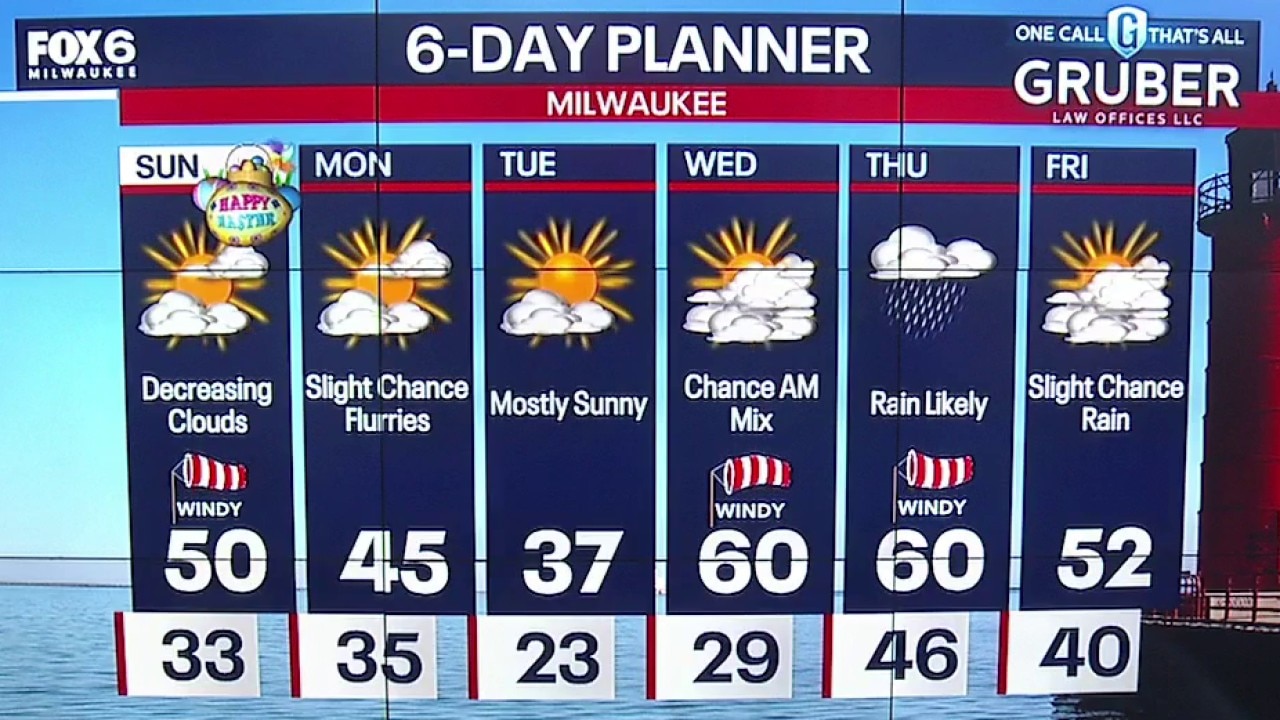
Weather webcast with Meteorologist Lisa Michaels
Gradual cloud clearing Sunday with highs near 50F. Windy all day with wind chills in the 30s and 40s.
Gradual cloud clearing Sunday with highs near 50F. Windy all day with wind chills in the 30s and 40s.
Weather Webcast with Holly Baker
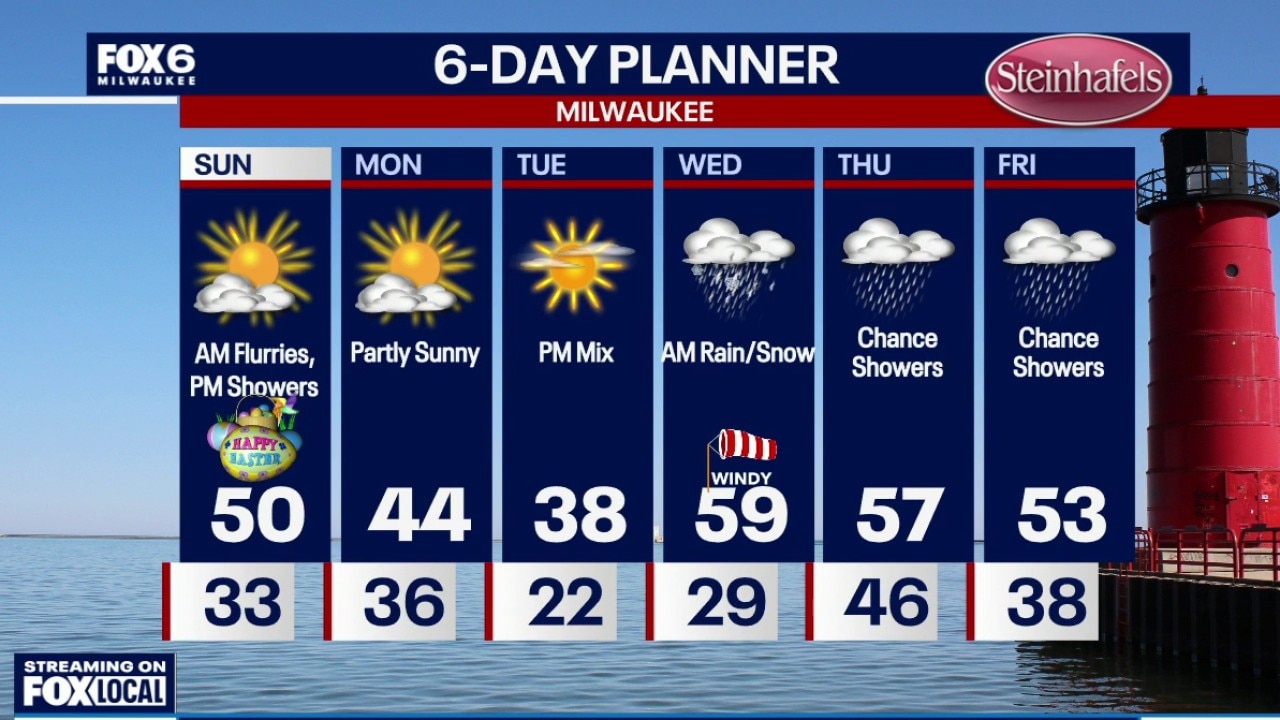
Much cooler for Easter Sunday with AM Flurries.
Much cooler for Easter Sunday with AM Flurries.
Weather webcast with meteorologist Lisa Michaels
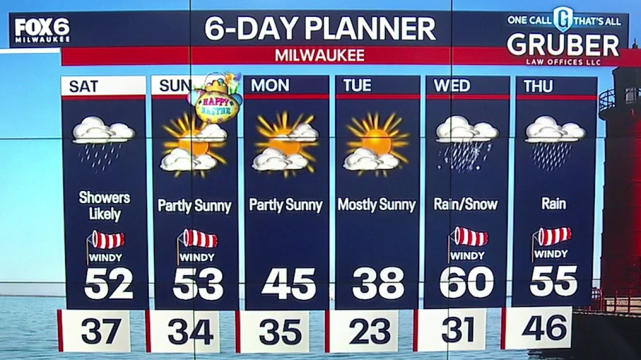
Rain showers continue into Saturday. Otherwise, cloudy and breezy with highs in the low 50s. Additional rain will increase the risk for localized low-level flooding and river flooding in areas. Be cautious when traveling this weekend.
Rain showers continue into Saturday. Otherwise, cloudy and breezy with highs in the low 50s. Additional rain will increase the risk for localized low-level flooding and river flooding in areas. Be cautious when traveling this weekend.
Weather Webcast with Holly Baker
We are tracking overnight showers and thunderstorms.
We are tracking overnight showers and thunderstorms.
Weather webcast with Holly Baker
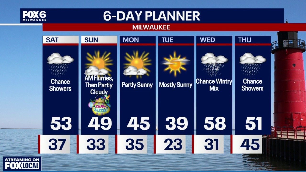
A progressive spring pattern remains in place across southern Wisconsin as another system brings strong storms our way late Friday into Saturday morning.
A progressive spring pattern remains in place across southern Wisconsin as another system brings strong storms our way late Friday into Saturday morning.